Alfington

Settlement in Devon East Devon

England

Alfington

Traffic passing Westleigh Willows Farm
Traffic passing Westleigh Willows Farm Credit: Rob Purvis

Alfington is a small village situated in the county of Devon in southwestern England. It is located about 10 miles east of the city of Exeter and falls within the East Devon district. Nestled in the picturesque Otter Valley, Alfington enjoys a tranquil rural setting, surrounded by rolling hills and verdant farmland.

The village itself is characterized by its charming thatched cottages, many of which date back several centuries, giving it a quintessentially English feel. The local community is close-knit and friendly, with a population of around 500 residents.

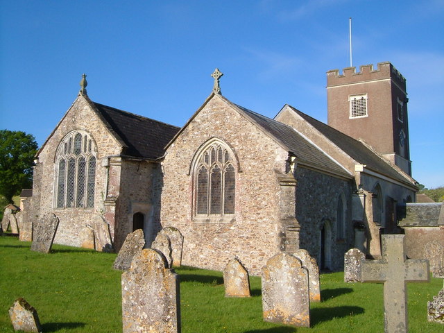
Alfington is well-served by local amenities, including a community hall, a primary school, and a popular pub, providing a central hub for social gatherings. The village is also home to St. Michael and All Angels Church, a beautiful historic building that dates back to the 13th century.

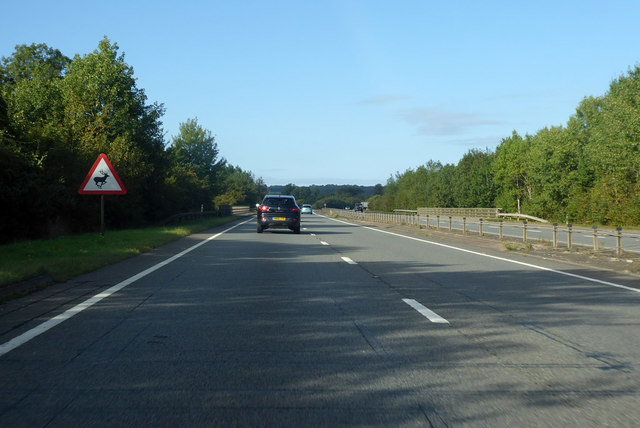
The surrounding countryside offers ample opportunities for outdoor activities, with numerous footpaths and bridleways crisscrossing the area. One such path leads to the nearby Alfington Beacon, a prominent hill that offers breathtaking panoramic views of the surrounding landscape.

Alfington benefits from its proximity to the bustling city of Exeter, which provides residents with access to a wide range of amenities, including shopping centers, restaurants, and cultural attractions. The village also benefits from good transport links, with regular bus services connecting it to neighboring towns and villages.

Overall, Alfington is a tranquil and picturesque village that offers a peaceful countryside lifestyle while still being within easy reach of larger urban centers.

If you have any feedback on the listing, please let us know in the comments section below.

Alfington Images

Images are sourced within 2km of 50.773363/-3.259358 or Grid Reference SY1197. Thanks to Geograph Open Source API. All images are credited.

Traffic passing Westleigh Willows Farm
Lay by near Patteson's Cross
Green Lane
Green Lane
Thatched cottages on Green Lane
Flyover bridge at Patteson's Cross
Old Other Stone - Patteson's Cross near the B3177, Ottery St Mary Parish Commemorative Marker by the UC road, just off the B3177, in parish of Ottery St Mary (East Devon District), Fairmile, at the junction of the old Exeter London Road and Ottery to Sidmouth Road, on a grass area, behind iron railings, below the new A30 junction.

Grade II listed. List Entry Number: 1213206
<span class="nowrap"><a title="https://historicengland.org.uk/listing/the-list/list-entry/1213206" rel="nofollow ugc noopener" href="https://historicengland.org.uk/listing/the-list/list-entry/1213206">Link</a><img style="margin-left:2px;" alt="External link" title="External link - shift click to open in new window" src="https://s1.geograph.org.uk/img/external.png" width="10" height="10"/></span>

Surveyed

Milestone Society National ID: DV_OTTcm
Old Other Stone - Patteson's Cross near the B3177, Ottery St Mary Parish
Commemorative Marker by the UC road, just off the B3177, in parish of Ottery St Mary (East Devon District), Fairmile, at the junction of the old Exeter London Road and Ottery to Sidmouth Road, on a grass area, behind iron railings, below the new A30 junction. Grade II listed. List Entry Number: 1213206 LinkExternal link Surveyed Milestone Society National ID: DV_OTTcm
A30 heading west Towards Exeter.
A30 heading west
Towards Exeter.
Ottery St Mary : Otter Nurseries Elephants on display with Christmas hats on.
Ottery St Mary : Otter Nurseries
Elephants on display with Christmas hats on.
Access to Colhayes farm Off the old Exeter road. Formerly the A30.
Access to Colhayes farm
Off the old Exeter road. Formerly the A30.
Approaching Fenny Bridges from the East The bridge crosses the River Otter at this point.
This at one point was the main route into Exeter from Honiton. The A30.
It is now much quieter due to the nearby by-pass.
Approaching Fenny Bridges from the East
The bridge crosses the River Otter at this point. This at one point was the main route into Exeter from Honiton. The A30. It is now much quieter due to the nearby by-pass.
 River Otter at Fenny Bridges Looking North. The main London to Exeter railway bridge can be seen in the background. Just out of sight is the new A30 Honiton by-pass.
River Otter at Fenny Bridges
Looking North. The main London to Exeter railway bridge can be seen in the background. Just out of sight is the new A30 Honiton by-pass.
You'll need a head for heights A Vodaphone team perform maintenance on their mast at Fenny Bridges.
You'll need a head for heights
A Vodaphone team perform maintenance on their mast at Fenny Bridges.
Lych gate to St James and St Anne's Church,  Alphington The gate was built in 1897 to commemorate the 60th year of Queen Victoria's reign.
Lych gate to St James and St Anne's Church, Alphington
The gate was built in 1897 to commemorate the 60th year of Queen Victoria's reign.
An OS Bench Mark Situated on the wall of Rock Farm.
An OS Bench Mark
Situated on the wall of Rock Farm.
Trackway from Alfington to Woodford Barton Rich with winter mud.
Trackway from Alfington to Woodford Barton
Rich with winter mud.
You'll get your boots dirty Recent rain has ponded next to a poorly drained footpath alongside the River Otter.
You'll get your boots dirty
Recent rain has ponded next to a poorly drained footpath alongside the River Otter.
Xmas Displays A variety of Xmas displays at the entrance to Ottery Garden Centre in Devon.
Xmas Displays
A variety of Xmas displays at the entrance to Ottery Garden Centre in Devon.
Lane heading west toward Feniton
Show me another place!

Alfington is located at Grid Ref: SY1197 (Lat: 50.773363, Lng: -3.259358)

Administrative County: Devon

District: East Devon

Police Authority: Devon and Cornwall

What 3 Words

///tips.smothered.passport. Near Ottery St Mary, Devon

Nearby Locations

Alfington

Related Wikis

St James and St Anne's Church, Alfington

St James' and St Anne's Church is a Church of England church in Alfington, Devon, England. It was built in 1849 at the expense of Sir John Taylor Coleridge...

Alfington

Alfington is a small village in East Devon, on the River Otter. It is 2 miles (3 km) north-east of Ottery St Mary. The church of St James (Church of England...

Ottery St Mary A.F.C.

Ottery St. Mary A.F.C., nicknamed "The Otters", is a football club based in Ottery St Mary, Devon, England. The club is affiliated to the Devon County...

Feniton

Feniton is a village and civil parish in East Devon in the English county of Devon. The village lies about 4 miles (6.4 km) west of Honiton, 3 miles (4...

Gittisham

Gittisham is a village and civil parish in East Devon, Devon, England, near Honiton. The village is 3 miles (5 km) from Ottery St Mary and it has a church...

Feniton railway station

Feniton railway station serves the village of Feniton in Devon, England. It was opened by the London and South Western Railway (LSWR) in 1860 but is now...

Pomeroy Wood

Pomeroy Wood is the site near Honiton in Devon of a Roman military site of unknown type, probably either a fort or marching camp, though archaeological...

St Mary's Church, Ottery St Mary

St Mary's Church is a Grade I listed building, a parish church in the Church of England in Ottery St Mary, Devon. The church is part of "Churches Together...

Nearby Amenities

Located within 500m of 50.773363,-3.259358
Alfington
Place: village
Wikidata: Q4721938
Lat/Long: 50.7726654/-3.2575093
Disused Amenity: post_box
Operator: Royal Mail
Operator Wikidata: Q638098
Post Box Mounting: brick_wall
Post Box Type: wall
Lat/Long: 50.7727548/-3.2579694
Post Box
Mapillary: 543027463991913
Operator: Royal Mail
Operator Wikidata: Q638098
Post Box Mounting: pier
Post Box Type: lamp
Lat/Long: 50.7718624/-3.2584457
Advertising: board
Lat/Long: 50.7718516/-3.2584612
The data included in this document is from www.openstreetmap.org. The data is made available under ODbL.

Have you been to Alfington?

Leave your review of Alfington below (or comments, questions and feedback).