Mappowder
Civil Parish in Dorset North Dorset
England
Mappowder

Mappowder is a picturesque civil parish located in the county of Dorset, England. It is situated in the Blackmore Vale, about 10 miles west of the town of Blandford Forum. The parish covers an area of approximately 7 square miles and is home to a small population of around 200 residents.
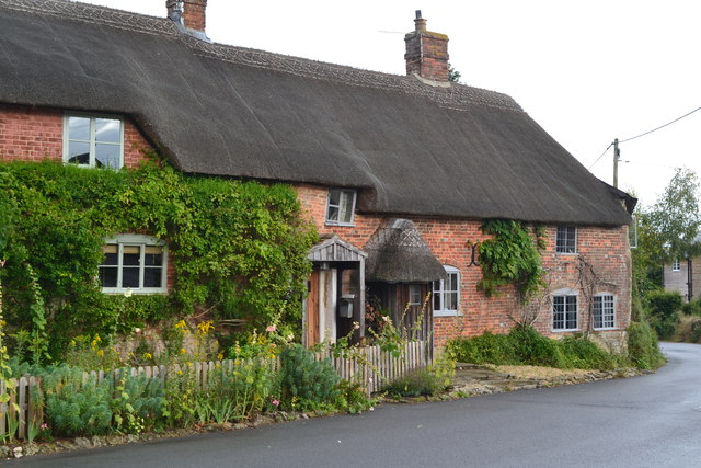
The village of Mappowder is known for its idyllic rural setting, with rolling hills, meadows, and charming cottages dotting the landscape. The centerpiece of the village is the St. Peter and St. Paul Church, a Grade II listed building that dates back to the 13th century. The church's stunning architecture and historical significance make it a popular attraction for visitors.
Despite its small size, Mappowder has a strong sense of community, with various social and cultural events organized throughout the year. The village also has a primary school, ensuring that local children have access to quality education.
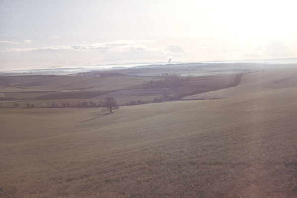
The surrounding countryside offers ample opportunities for outdoor activities such as walking, cycling, and horse riding. The nearby Blackmore Vale is renowned for its scenic beauty and is a haven for nature lovers and wildlife enthusiasts.
In terms of amenities, Mappowder has limited facilities, with no shops or pubs within the immediate vicinity. However, the village is within easy reach of larger towns and cities, such as Blandford Forum and Dorchester, where residents can access a wider range of services and amenities.
Overall, Mappowder is a charming and tranquil village that offers a peaceful retreat from the hustle and bustle of city life. Its natural beauty, sense of community, and historical landmarks make it an attractive place to live or visit.
If you have any feedback on the listing, please let us know in the comments section below.
Mappowder Images
Images are sourced within 2km of 50.857804/-2.381005 or Grid Reference ST7306. Thanks to Geograph Open Source API. All images are credited.


Mappowder is located at Grid Ref: ST7306 (Lat: 50.857804, Lng: -2.381005)
Administrative County: Dorset
District: North Dorset
Police Authority: Dorset
What 3 Words
///compiled.convinces.windy. Near Sturminster Newton, Dorset
Related Wikis
Dorset Downs
The Dorset Downs are an area of chalk downland in the centre of the county Dorset in south west England. The downs are the most western part of a larger...

Mappowder
Mappowder is a village and civil parish in the county of Dorset in southern England. The parish lies approximately 9 miles (14 kilometres) southeast of...

Hazelbury Bryan
Hazelbury Bryan is a village and civil parish in the county of Dorset in southern England. It is situated in the Blackmore Vale, approximately five miles...

Stoke Wake
Stoke Wake is a hamlet and civil parish, formerly part of the Whiteway hundred in north Dorset, England. It is situated under Bulbarrow Hill on the edge...

Ball Hill, Dorset
At 251 metres, Ball Hill is one of the highest hills in the county of Dorset, England, and is on the Wessex Ridgeway. == Location == The summit of Ball...

Pulham
Pulham is a village and civil parish in the county of Dorset in south-west England. It is situated in the Blackmore Vale, 7 miles (11 kilometres) southeast...

Bulbarrow Hill
Bulbarrow Hill is a 274 metres (899 ft) hill near Woolland, five miles west of Blandford Forum and ten miles (16 km) north of Dorchester in Dorset, England...

Bookham Knoll
Bookham Knoll is a rounded hill, 211 metres (692 ft) high, about 1 kilometre southeast of the village of Buckland Newton in the county of Dorset in southern...
Nearby Amenities
Located within 500m of 50.857804,-2.381005Have you been to Mappowder?
Leave your review of Mappowder below (or comments, questions and feedback).