Knill

Civil Parish in Herefordshire

England

Knill

On the Mortimer Trail - eastern shoulder of Rushoak Hill
On the Mortimer Trail - eastern shoulder of Rushoak Hill Credit: Colin Park

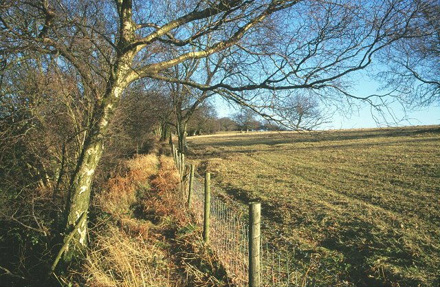
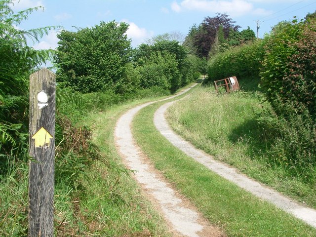
Knill is a small civil parish located in the county of Herefordshire, England. Situated approximately 9 miles northwest of the city of Hereford, Knill covers an area of around 3.5 square miles. It is a rural parish characterized by picturesque countryside, rolling hills, and scattered farms.

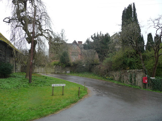
The parish is home to a small population of around 260 residents, according to the latest available census data. The village of Knill itself is the primary settlement within the parish, with a handful of residential properties, a local pub, and a village hall. The village hall serves as a hub for community events and gatherings, such as meetings, social activities, and occasional celebrations.

One of the notable landmarks in Knill is Knill Court, a historic country house surrounded by beautiful gardens. The house dates back to the 17th century and has been well-preserved over the years. It serves as a private residence and is not open to the public.

The surrounding countryside offers ample opportunities for outdoor activities, including hiking, cycling, and wildlife spotting. The parish is also known for its agricultural activities, with a number of farms and agricultural businesses operating in the area.

Overall, Knill, Herefordshire is a peaceful and idyllic rural parish, offering a close-knit community, stunning natural scenery, and a tranquil way of life.

If you have any feedback on the listing, please let us know in the comments section below.

Knill Images

Images are sourced within 2km of 52.243439/-3.037767 or Grid Reference SO2961. Thanks to Geograph Open Source API. All images are credited.

On the Mortimer Trail - eastern shoulder of Rushoak Hill
Track to Herrock Hill
Knill Garraway Wood Viewed from a track to Herrock Hill.
Knill Garraway Wood
Viewed from a track to Herrock Hill.
Bench on Herrock Hill This bench is on the peak of the 1,217ft (371m) high Herrock Hill, with a quote from Muhammad Ali that reads "Don't count the days, make the days count".
Bench on Herrock Hill
This bench is on the peak of the 1,217ft (371m) high Herrock Hill, with a quote from Muhammad Ali that reads "Don't count the days, make the days count".
Trees by Herrock Hill The two trees in view are situated east from Herrock Hill.
Trees by Herrock Hill
The two trees in view are situated east from Herrock Hill.
Little Brampton Scar Above the scarp slopes on the long Silurian limestone ridge running from the Severn to the Wye. The plateau and dip slopes are agricultural, the scarp, north facing is wooded. Sometimes there were common grazings on the scarp slopes, but these have often reverted to woodland, a process visible at Byton SO3763 and Yatton Commons. SO4366. A footpath is squeezed between the fence and the wood.
Little Brampton Scar
Above the scarp slopes on the long Silurian limestone ridge running from the Severn to the Wye. The plateau and dip slopes are agricultural, the scarp, north facing is wooded. Sometimes there were common grazings on the scarp slopes, but these have often reverted to woodland, a process visible at Byton SO3763 and Yatton Commons. SO4366. A footpath is squeezed between the fence and the wood.
On the Mortimer Trail near Stocking Wood
Quarry Pool at Nash Quarry View westwards over the ice-covered pool to the steep hillside of Knill Wood. The quarry is disused and the pool looks deep and dangerous.
Quarry Pool at Nash Quarry
View westwards over the ice-covered pool to the steep hillside of Knill Wood. The quarry is disused and the pool looks deep and dangerous.
Overgrown track junction near Nash Completely overgrown and partly blocked by fallen trees further back, this is supposed to be a maintained footpath.
Overgrown track junction near Nash
Completely overgrown and partly blocked by fallen trees further back, this is supposed to be a maintained footpath.
Blocked footpath near Nash 2008 This is supposed to be a cycleway as well as a footpath between Nash and Little Brampton.  Someone's playing silly whatsits...
Blocked footpath near Nash 2008
This is supposed to be a cycleway as well as a footpath between Nash and Little Brampton. Someone's playing silly whatsits...
Footpath toward Nash Scar 2008
Footpath off Nash road 2008
Upper Nash Farm 2008
Broadhurst Bridge, near Nash - 2008 Junction to Little Brampton in the foreground.
Broadhurst Bridge, near Nash - 2008
Junction to Little Brampton in the foreground.
Towards Little Brampton 2008
Shed on the edge of Knill Wood View south-east across the Hindwell valley to Wapley Hill.
Shed on the edge of Knill Wood
View south-east across the Hindwell valley to Wapley Hill.
Quarry spoil tip at Nash Quarry The footpath heads eastwards below large quarry spoil tips.
Quarry spoil tip at Nash Quarry
The footpath heads eastwards below large quarry spoil tips.
Nash Scar - 1 The old quarry track heading north-east is dwarfed by the size of this slice off the side of the hill. The Nash Scar is formed of Woolhope limestone which was subsequently fused into one crystalline mass of igneous rock, perhaps the best example of such rock in the UK. This quarry was a major source of crushed rock, but for the time being it seems to be resting.
Nash Scar - 1
The old quarry track heading north-east is dwarfed by the size of this slice off the side of the hill. The Nash Scar is formed of Woolhope limestone which was subsequently fused into one crystalline mass of igneous rock, perhaps the best example of such rock in the UK. This quarry was a major source of crushed rock, but for the time being it seems to be resting.
Show me another place!

Knill is located at Grid Ref: SO2961 (Lat: 52.243439, Lng: -3.037767)

Unitary Authority: County of Herefordshire

Police Authority: West Mercia

What 3 Words

///scarcely.views.overheard. Near Presteigne, Powys

Nearby Locations

Knill

Related Wikis

Knill

Knill is a village and civil parish in Herefordshire, England. == History == Recorded in the Domesday Book of 1086 as Chenille (from the Old English meaning...

Burfa Castle

Burfa Castle (also known as Burfa Hillfort, Burfa Bank Hillfort, or Burfa Camp) is an Iron Age hillfort near the tiny town of Old Radnor, Radnorshire in...

Lower Harpton

Lower Harpton is a settlement and civil parish about 2.5 miles of Knighton, in the county of Herefordshire, England. In 2001, the parish had a population...

Rodd, Nash and Little Brampton

Rodd, Nash and Little Brampton is a civil parish in the county of Herefordshire, England, and is 18 miles (29 km) north-west from the city and county town...

Rushock, Herefordshire

Rushock is a small village in Herefordshire, England. It lies about 1 mile north-east of Kington. The population of the civil parish was 131 at the 2011...

Titley Pool

Titley Pool is a lake in Herefordshire, England. It is situated at Titley, 3 kilometres (1.9 mi) north west of the town of Kington. It is a naturally...

Stanner Rocks

Stanner Rocks is a rounded hill, steep in parts, which lies close to the Wales border with England between Walton and Kington. A superb collection of wild...

Presteign railway station

Presteign Railway Station was a railway station serving the town of Presteigne, Radnorshire, Wales. It was a terminus on the Leominster and Kington Railway...

Nearby Amenities

Located within 500m of 52.243439,-3.037767
Knill
Place: hamlet
Source: NLS - OS 1:25k 1st Series 1937-61
Wikidata: Q3785313
Lat/Long: 52.2395167/-3.0397717
Barrier: cattle_grid
Lat/Long: 52.2389426/-3.0380182
Information: guidepost
Tourism: information
Lat/Long: 52.2392566/-3.0386527
The data included in this document is from www.openstreetmap.org. The data is made available under ODbL.

Have you been to Knill?

Leave your review of Knill below (or comments, questions and feedback).