Kirby Bedon

Civil Parish in Norfolk South Norfolk

England

Kirby Bedon

Thorpe Marshes Nature Reserve
Thorpe Marshes Nature Reserve Credit: Jeremy Halls

Kirby Bedon is a civil parish located in the county of Norfolk, England. It is situated approximately 5 miles south-east of the city of Norwich, the county's administrative center. The parish covers an area of around 2.5 square miles and is home to a small population.

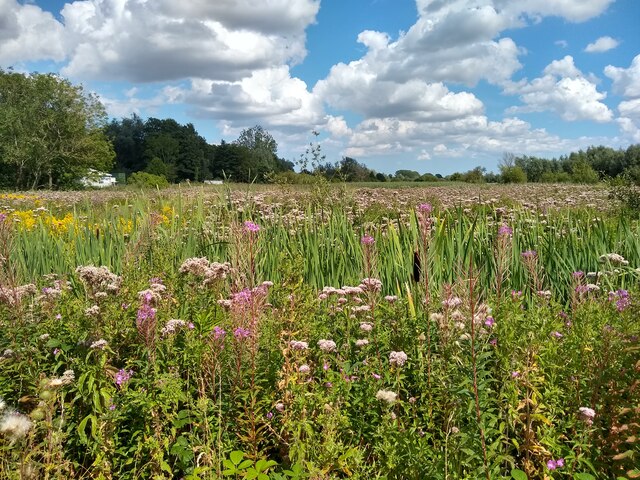
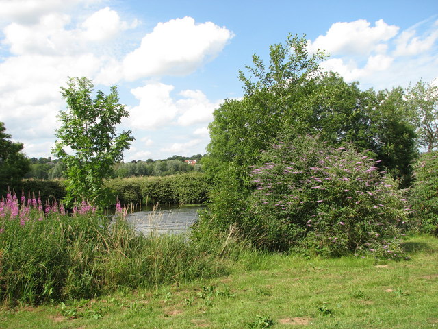
Kirby Bedon is a rural village characterized by its picturesque countryside and peaceful atmosphere. The village is surrounded by open fields, farmland, and woodlands, offering residents and visitors ample opportunities for outdoor activities and scenic walks. The River Yare, which flows nearby, adds to the natural beauty of the area.

In terms of amenities, Kirby Bedon has limited facilities. The village does not have its own shop or post office, so residents typically rely on neighboring villages for their daily needs. However, the village does have a local pub, providing a place for socializing and community gatherings.

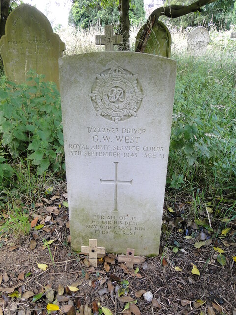
Historically, Kirby Bedon was mentioned in the Domesday Book of 1086, and some of its buildings date back to the medieval period. The village's parish church, St. Andrew's, is a notable landmark and features beautiful architecture.

Overall, Kirby Bedon offers a tranquil and idyllic setting for those seeking a rural lifestyle. Its close proximity to Norwich also provides easy access to a wider range of amenities and services.

If you have any feedback on the listing, please let us know in the comments section below.

Kirby Bedon Images

Images are sourced within 2km of 52.620757/1.357085 or Grid Reference TG2707. Thanks to Geograph Open Source API. All images are credited.

Thorpe Marshes Nature Reserve
Yellow Iris, Thorpe Marshes Nature Reserve
War Grave of George William West RASC Driver George William West was the son of Edmund and Gertrude West, of Lakenham. He married Amy Elizabeth Newitt in 1939 and lived at Hill Cottages in Whitlingham. He served as a driver in the RASC, 593 Transport Coy, and in the Ammunition Column for 33rd Brigade. He was injured and returned home where he died 13th September 1943. He is buried in Thorpe (St Andrew) Church Cemetery extension. His memorial can be seen here <a title="https://www.geograph.org.uk/photo/6590004" href="https://www.geograph.org.uk/photo/6590004">Link</a>
War Grave of George William West RASC Driver
George William West was the son of Edmund and Gertrude West, of Lakenham. He married Amy Elizabeth Newitt in 1939 and lived at Hill Cottages in Whitlingham. He served as a driver in the RASC, 593 Transport Coy, and in the Ammunition Column for 33rd Brigade. He was injured and returned home where he died 13th September 1943. He is buried in Thorpe (St Andrew) Church Cemetery extension. His memorial can be seen here Link
Old Milepost by the A1042, Yarmouth Road, Thorpe St Andrew Cast iron post by the A1042, in parish of Thorpe St Andrew (Broadland District), 50yds East of bridge, against flint wall at rear of pavement, on North side of road. Erected by the Norwich & Yarmouth turnpike trust in the 19th century. An earlier photograph can be found here <a title="https://www.geograph.org.uk/photo/6096355" href="https://www.geograph.org.uk/photo/6096355">Link</a>.

Inscription reads:-
: YARMOUTH / 19 : : THORPE : : NORWICH / 3 :

Norfolk HER.
NHER Number: 56574 <span class="nowrap"><a title="https://www.heritagegateway.org.uk/Gateway/Results_Single.aspx?uid=MNF62993&resourceID=1002" rel="nofollow ugc noopener" href="https://www.heritagegateway.org.uk/Gateway/Results_Single.aspx?uid=MNF62993&resourceID=1002">Link</a><img style="margin-left:2px;" alt="External link" title="External link - shift click to open in new window" src="https://s1.geograph.org.uk/img/external.png" width="10" height="10"/></span>

Milestone Society National ID: NO_NGY03
Old Milepost by the A1042, Yarmouth Road, Thorpe St Andrew
Cast iron post by the A1042, in parish of Thorpe St Andrew (Broadland District), 50yds East of bridge, against flint wall at rear of pavement, on North side of road. Erected by the Norwich & Yarmouth turnpike trust in the 19th century. An earlier photograph can be found here Link. Inscription reads:- : YARMOUTH / 19 : : THORPE : : NORWICH / 3 : Norfolk HER. NHER Number: 56574 LinkExternal link Milestone Society National ID: NO_NGY03
The River Yare by Hall Farm, Postwick
Derelict boat moored on the River Yare by Hall Farm, Postwick
Derelict boat by Hall Farm, Postwick
Ditch by Hall Farm, Postwick
Gate on footpath along the River Yare, Postwick
Here ends the water ski area Taken from the footpath along the River Yare, south-west of Postwick.
Here ends the water ski area
Taken from the footpath along the River Yare, south-west of Postwick.
Grazing by the River Yare A public footpath runs along here, leading to Thorpe St Andrew's on the eastern fringe of Norwich.
Grazing by the River Yare
A public footpath runs along here, leading to Thorpe St Andrew's on the eastern fringe of Norwich.
Derelict 'dolphin' east of the Postwick aqueduct This wooden structure, now derelict, served for mooring cargo vessels that were travelling up or down the River Yare.
Derelict 'dolphin' east of the Postwick aqueduct
This wooden structure, now derelict, served for mooring cargo vessels that were travelling up or down the River Yare.
Footpath from Thorpe St Andrew's  to Postwick Marshes It leads along the River Yare.
Footpath from Thorpe St Andrew's to Postwick Marshes
It leads along the River Yare.
Trees growing in the River Yare This view was taken from the public footpath leading from Thorpe St Andrew's to the Postwick Marshes.
Trees growing in the River Yare
This view was taken from the public footpath leading from Thorpe St Andrew's to the Postwick Marshes.
Reflections in the River Yare Looking across the river from the public footpath leading from Thorpe St Andrew's to the Postwick Marshes. Whitlingham Marsh is on the other side of the river.
Reflections in the River Yare
Looking across the river from the public footpath leading from Thorpe St Andrew's to the Postwick Marshes. Whitlingham Marsh is on the other side of the river.
Daffodils on the bank of the River Yare South-west of the Postwick aqueduct.
Daffodils on the bank of the River Yare
South-west of the Postwick aqueduct.
Daffodils on the bank of the River Yare This view was taken from the public footpath that leads from Thorpe St Andrew's  to the Postwick Marshes.
Daffodils on the bank of the River Yare
This view was taken from the public footpath that leads from Thorpe St Andrew's to the Postwick Marshes.
Footpath from Thorpe St Andrew's  to Postwick Marshes It leads along the River Yare.
Footpath from Thorpe St Andrew's to Postwick Marshes
It leads along the River Yare.
Show me another place!

Kirby Bedon is located at Grid Ref: TG2707 (Lat: 52.620757, Lng: 1.357085)

Administrative County: Norfolk

District: South Norfolk

Police Authority: Norfolk

What 3 Words

///brands.gladiators.nurses. Near Thorpe Hamlet, Norfolk

Related Wikis

Whitlingham

Whitlingham is a small hamlet and former parish at the mouth of the River Wensum in Norfolk, England. It is located 3 miles (5 km) east of Norwich, on...

Whitlingham Marsh

Whitlingham Marsh is a 15.5-hectare (38-acre) Local Nature Reserve in Norwich in Norfolk. It is owned by South Norfolk District Council and managed by...

Thorpe Marshes

Thorpe Marshes is a 25-hectare (62-acre) nature reserve east of Norwich in Norfolk. It is managed by the Norfolk Wildlife Trust.This site has a lake called...

Whitlingham railway station

Whitlingham was a station in Whitlingham, Norfolk. The simple station has been demolished leaving no trace of its existence. However the footbridge is...

St Andrew's Hospital, Norwich

St Andrew's Hospital was a mental health facility in Thorpe St Andrew, Norwich, Norfolk, England. The main building survives and it is a Grade II listed...

Thorpe rail accident

The Thorpe rail accident occurred on 10 September 1874 when two trains were involved in a head-on collision at Thorpe St Andrew, Norfolk, England.The accident...

Broadland

Broadland is a local government district in Norfolk, England, named after the Norfolk Broads. Its council is based at the Broadland Business Park on the...

Thorpe St Andrew School

Thorpe St. Andrew School is an 11 to 18 mixed secondary school in Thorpe St. Andrew on the outskirts of the city of Norwich in the English county of Norfolk...

Nearby Amenities

Located within 500m of 52.620757,1.357085
Source: Landsat photo - shifted
Lat/Long: 52.6211624/1.3506115
Source: Landsat photo - shifted
Lat/Long: 52.6213325/1.3519006
Source: Landsat photo - shifted
Lat/Long: 52.6217068/1.3533018
Source: Landsat photo - shifted
Lat/Long: 52.6220044/1.3548711
Source: Landsat photo - shifted
Lat/Long: 52.6222929/1.3561602
Source: Landsat photo - shifted
Lat/Long: 52.6224213/1.357113
Source: Landsat photo - shifted
Lat/Long: 52.6225914/1.3581219
Source: Landsat photo - shifted
Lat/Long: 52.6227691/1.3591967
Source: Landsat photo - shifted
Lat/Long: 52.6229103/1.36001
Source: Landsat photo - shifted
Lat/Long: 52.6234782/1.3619331
Parking
Access: yes
Fee: no
Parking: layby
Lat/Long: 52.6194232/1.3531623
Bench
Backrest: no
Material: wood
Seats: 2
Lat/Long: 52.621398/1.3504273
Bench
Backrest: no
Material: wood
Seats: 2
Lat/Long: 52.6216414/1.3520985
Whitlingham Barns
Place: locality
Source: survey
Lat/Long: 52.619713/1.3593856
Barrier: stile
Foot: yes
Material: wood
Stile: stepover
Lat/Long: 52.6193302/1.3608776
Barrier: stile
Foot: yes
Material: wood
Stile: stepover
Lat/Long: 52.6201409/1.3596935
Access: private
Communication Mobile Phone: yes
Man Made: mast
Material: metal
Operator: O2-UK;Vodafone UK
Source: survey
Tower Construction: freestanding
Tower Type: communication
Lat/Long: 52.6194972/1.3611062
Leisure: picnic_table
Lat/Long: 52.6207793/1.3530415
Barrier: kissing_gate
Foot: yes
Lat/Long: 52.6228031/1.3550078
Phone
Emergency: phone
Ref: 244A
Lat/Long: 52.6195376/1.353509
Hill Cottages
Place: locality
Lat/Long: 52.6181731/1.355404
Holmemead
Place: locality
Lat/Long: 52.6188999/1.3555686
Lime Kiln
Description: Now protected for a bat colony roost.
Historic: ruins
Lat/Long: 52.6206517/1.3545088
Saint Andrew's Church
Abandoned Amenity: place_of_worship
Denomination: anglican
Historic: ruins
Listed Status: Grade II
Material: stone
Religion: christian
Ruins: church
Short Name: Saint Andrew
Tower: round
Website: http://www.heritage.norfolk.gov.uk/record-details?MNF9692
Lat/Long: 52.6208633/1.3579723
Whitlingham Marsh Local Nature Reserve
Board Type: nature
Information: board
Tourism: information
Lat/Long: 52.6209259/1.3593505
Bench
Backrest: no
Material: wood
Lat/Long: 52.6205042/1.3544337
Leisure: picnic_table
Material: wood
Lat/Long: 52.6205166/1.3541414
Bench
Backrest: no
Material: wood
Lat/Long: 52.6205298/1.3544712
Bicycle Parking
Bicycle Parking: stands
Capacity: 4
Covered: no
Lat/Long: 52.6207853/1.3512722
Leisure: playground
Material: wood
Lat/Long: 52.6207974/1.3527774
Vending Machine
Vending: parking_tickets
Lat/Long: 52.6208265/1.3516634
Waste Basket
Waste: dog_excrement
Lat/Long: 52.6208183/1.3516835
Traffic Calming: hump
Lat/Long: 52.6208713/1.3498253
Waste Basket
Lat/Long: 52.6207973/1.3516533
Bicycle Parking
Bicycle Parking: stands
Capacity: 4
Covered: no
Lat/Long: 52.6208846/1.3517385
Board Type: nature
Information: board
Tourism: information
Lat/Long: 52.6208887/1.3516565
Leisure: picnic_table
Lat/Long: 52.6209064/1.3525366
Waste Basket
Lat/Long: 52.6209788/1.3595561
Traffic Calming: hump
Lat/Long: 52.6213423/1.3572152
Life Ring
Emergency: life_ring
Lat/Long: 52.6217084/1.3554086
FIXME: Follow path to find where it connects/ends
Lat/Long: 52.6222072/1.3590787
Barrier: kissing_gate
Foot: yes
Lat/Long: 52.6241119/1.3539308
Board Type: nature
Description: Pictures/description of birds and habitat.
Information: board
Tourism: information
Lat/Long: 52.6219687/1.3531027
Bench
Backrest: yes
Material: wood
Seats: 3
Lat/Long: 52.6219626/1.3531523
Bench
Backrest: yes
Material: wood
Seats: 3
Lat/Long: 52.6219455/1.3530752
Barrier: stile
Lat/Long: 52.624374/1.3576739
Barrier: bollard
Bollard: fixed
Lat/Long: 52.6205952/1.3509807
Barrier: bollard
Bollard: fixed
Lat/Long: 52.6205844/1.3509052
Bench
Backrest: yes
Material: wood
Seats: 2
Lat/Long: 52.621135/1.351826
Barrier: bollard
Bollard: fixed
Lat/Long: 52.6205898/1.3509494
Bicycle Parking
Bicycle Parking: stands
Capacity: 4
Capacity Cargo Bike: 1
Lat/Long: 52.6211831/1.3532662
Tree: yes
Lat/Long: 52.6206063/1.3510293
Barrier: bollard
Bollard: fixed
Lat/Long: 52.6205707/1.3508241
Barrier: bollard
Bollard: fixed
Lat/Long: 52.6205749/1.3508675
The data included in this document is from www.openstreetmap.org. The data is made available under ODbL.

Have you been to Kirby Bedon?

Leave your review of Kirby Bedon below (or comments, questions and feedback).