Kingstone

Civil Parish in Somerset South Somerset

England

Kingstone

St. Mary's, Seavington St. Mary, Somerset Originally built in the 13th Century, the church was extensively rebuilt in the 15th with some restoration in the late 19th.
St. Mary's, Seavington St. Mary, Somerset Credit: Ray Jennings

Kingstone is a civil parish located in the county of Somerset, in the southwestern part of England. It is situated approximately 10 miles west of the city of Taunton, and covers an area of around 4 square miles. The parish is mainly rural, with a small population of around 250 residents.

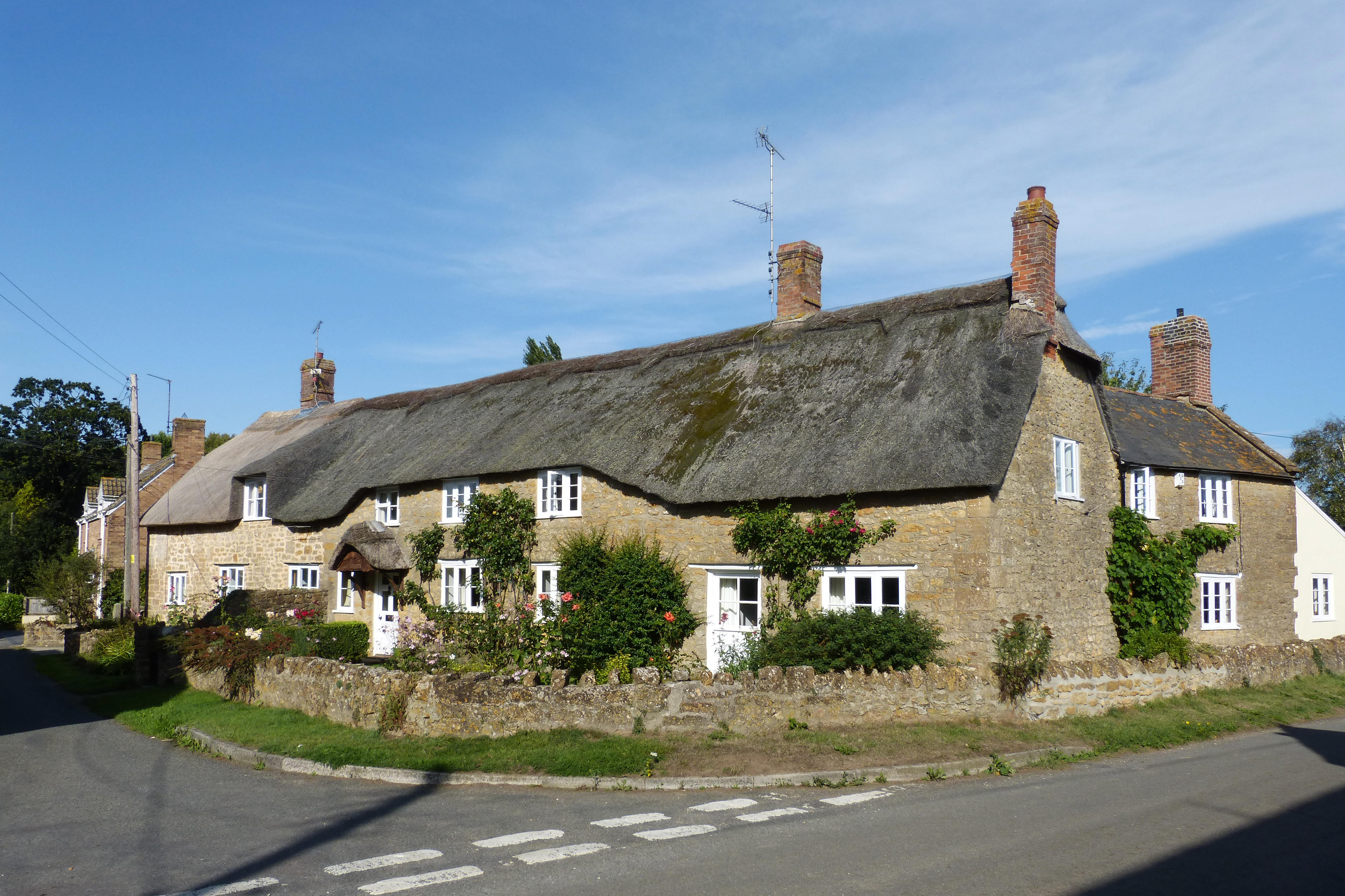
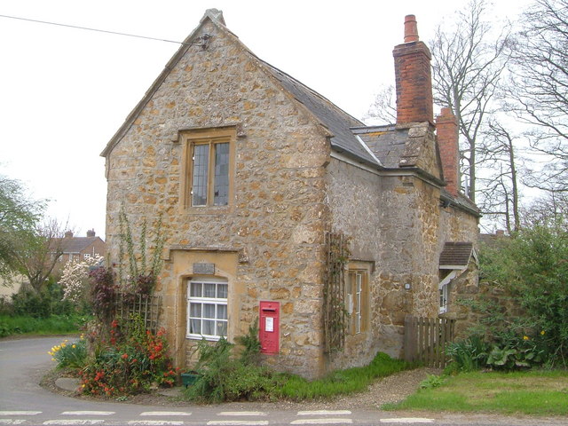
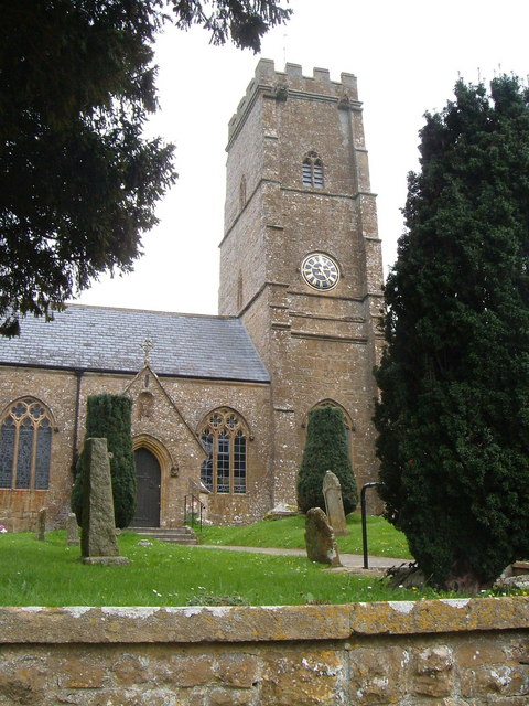
The village of Kingstone is the main settlement within the parish, and it is characterized by its picturesque countryside surroundings and charming traditional houses. The village is centered around the All Saints Church, a historic building that dates back to the 14th century. The church is known for its beautiful stained glass windows and intricate stone carvings.

Agriculture plays a significant role in the local economy, with farming being the main occupation of many residents. The fertile land in and around Kingstone is used for the cultivation of crops such as wheat, barley, and potatoes. Livestock farming, particularly sheep and cattle rearing, is also prevalent.

The parish is well-connected to surrounding areas by a network of roads, making it easily accessible for visitors. The nearby Quantock Hills, designated as an Area of Outstanding Natural Beauty, offer opportunities for outdoor activities such as hiking and cycling. The coast is also within a short drive, providing access to stunning beaches and coastal walks.

Overall, Kingstone, Somerset is a tranquil and idyllic parish, known for its rural beauty and agricultural heritage. It offers a peaceful retreat for residents and visitors alike, with its charming village, fertile farmland, and proximity to natural attractions.

If you have any feedback on the listing, please let us know in the comments section below.

Kingstone Images

Images are sourced within 2km of 50.916866/-2.867371 or Grid Reference ST3913. Thanks to Geograph Open Source API. All images are credited.

St. Mary's, Seavington St. Mary, Somerset Originally built in the 13th Century, the church was extensively rebuilt in the 15th with some restoration in the late 19th.
St. Mary's, Seavington St. Mary, Somerset
Originally built in the 13th Century, the church was extensively rebuilt in the 15th with some restoration in the late 19th.
St. Mary's, Seavington St. Mary, Somerset The Tower and North wall.
St. Mary's, Seavington St. Mary, Somerset
The Tower and North wall.
St. Mary's, Seavington St. Mary, Somerset North-East corner.
St. Mary's, Seavington St. Mary, Somerset
North-East corner.
St. Mary's, Seavington St. Mary, Somerset The Nave.
St. Mary's, Seavington St. Mary, Somerset
The Nave.
St. Mary's, Seavington St. Mary, Somerset The Chancel and Apse.
St. Mary's, Seavington St. Mary, Somerset
The Chancel and Apse.
St John and All Saints church, Kingstone The medieval church <span class="nowrap"><a title="http://webapp1.somerset.gov.uk/her/details.asp?prn=56710" rel="nofollow ugc noopener" href="http://webapp1.somerset.gov.uk/her/details.asp?prn=56710">Link</a><img style="margin-left:2px;" alt="External link" title="External link - shift click to open in new window" src="https://s1.geograph.org.uk/img/external.png" width="10" height="10"/></span> from the south.
St John and All Saints church, Kingstone
The medieval church LinkExternal link from the south.
Dowlish Wake from the churchyard Looking SSW from the churchyard down the village street. A reverse view of <a href="https://www.geograph.org.uk/photo/3715773">ST3712 : Entrance to churchyard, Dowlish Wake</a>; on the right is the scene in <a href="https://www.geograph.org.uk/photo/3715820">ST3712 : Lane at Dowlish Wake</a>.
Dowlish Wake from the churchyard
Looking SSW from the churchyard down the village street. A reverse view of ST3712 : Entrance to churchyard, Dowlish Wake; on the right is the scene in ST3712 : Lane at Dowlish Wake.
Wake Hill, Kingstone Early C19 house - "in a later form of 'cottage ornee' (<span class="nowrap"><a title="http://webapp1.somerset.gov.uk/her/details.asp?prn=57246" rel="nofollow ugc noopener" href="http://webapp1.somerset.gov.uk/her/details.asp?prn=57246">Link</a><img style="margin-left:2px;" alt="External link" title="External link - shift click to open in new window" src="https://s1.geograph.org.uk/img/external.png" width="10" height="10"/></span> )
Wake Hill, Kingstone
Early C19 house - "in a later form of 'cottage ornee' (LinkExternal link )
Old Toll House, Kingstone <span class="nowrap"><a title="http://webapp1.somerset.gov.uk/her/details.asp?prn=57243" rel="nofollow ugc noopener" href="http://webapp1.somerset.gov.uk/her/details.asp?prn=57243">Link</a><img style="margin-left:2px;" alt="External link" title="External link - shift click to open in new window" src="https://s1.geograph.org.uk/img/external.png" width="10" height="10"/></span> . George V postbox TA19 19 is on the wall. See also <a href="https://www.geograph.org.uk/photo/3715963">ST3713 : Old Toll House, Kingstone</a>.
Old Toll House, Kingstone
LinkExternal link . George V postbox TA19 19 is on the wall. See also ST3713 : Old Toll House, Kingstone.
Barn conversion, Kingstone Farmhouse The pre-conversion photo, taken in 1986, at <span class="nowrap"><a title="http://webapp1.somerset.gov.uk/her/details.asp?prn=56718" rel="nofollow ugc noopener" href="http://webapp1.somerset.gov.uk/her/details.asp?prn=56718">Link</a><img style="margin-left:2px;" alt="External link" title="External link - shift click to open in new window" src="https://s1.geograph.org.uk/img/external.png" width="10" height="10"/></span> makes an interesting comparison. Listed and described at <span class="nowrap"><a title="https://historicengland.org.uk/listing/the-list/list-entry/1056989" rel="nofollow ugc noopener" href="https://historicengland.org.uk/listing/the-list/list-entry/1056989">Link</a><img style="margin-left:2px;" alt="External link" title="External link - shift click to open in new window" src="https://s1.geograph.org.uk/img/external.png" width="10" height="10"/></span>  .
Barn conversion, Kingstone Farmhouse
The pre-conversion photo, taken in 1986, at LinkExternal link makes an interesting comparison. Listed and described at LinkExternal link .
Kingstone church from the south Looking across a field of brassica, past a little stand of trees in its midst, from the footpath to Dowlish Wake.
Kingstone church from the south
Looking across a field of brassica, past a little stand of trees in its midst, from the footpath to Dowlish Wake.
St Andrew's church, Dowlish Wake <span class="nowrap"><a title="http://webapp1.somerset.gov.uk/her/details.asp?prn=57228" rel="nofollow ugc noopener" href="http://webapp1.somerset.gov.uk/her/details.asp?prn=57228">Link</a><img style="margin-left:2px;" alt="External link" title="External link - shift click to open in new window" src="https://s1.geograph.org.uk/img/external.png" width="10" height="10"/></span>
St Andrew's church, Dowlish Wake
Dower House , Dowlish Wake Fine 1664 house in Ham stone, with a five-light mullioned window, at the centre of the charming village. Details at <span class="nowrap"><a title="http://webapp1.somerset.gov.uk/her/details.asp?prn=57233" rel="nofollow ugc noopener" href="http://webapp1.somerset.gov.uk/her/details.asp?prn=57233">Link</a><img style="margin-left:2px;" alt="External link" title="External link - shift click to open in new window" src="https://s1.geograph.org.uk/img/external.png" width="10" height="10"/></span> .
Dower House , Dowlish Wake
Fine 1664 house in Ham stone, with a five-light mullioned window, at the centre of the charming village. Details at LinkExternal link .
Packhorse Bridge, Dowlish Wake The 2-arch bridge was widened in the 1990s as part of flood relief work - quite cleverly (can you see the joins?). <span class="nowrap"><a title="http://webapp1.somerset.gov.uk/her/details.asp?prn=17080" rel="nofollow ugc noopener" href="http://webapp1.somerset.gov.uk/her/details.asp?prn=17080">Link</a><img style="margin-left:2px;" alt="External link" title="External link - shift click to open in new window" src="https://s1.geograph.org.uk/img/external.png" width="10" height="10"/></span>
Packhorse Bridge, Dowlish Wake
The 2-arch bridge was widened in the 1990s as part of flood relief work - quite cleverly (can you see the joins?). LinkExternal link
Not St George's Day In Dowlish Wake village on St George's Eve. Hope it won whatever competition it was in for.
Not St George's Day
In Dowlish Wake village on St George's Eve. Hope it won whatever competition it was in for.
Perry's Cider Mill, Dowlish Wake Offering a tea room and shop as well as producing cider. <span class="nowrap"><a title="http://webapp1.somerset.gov.uk/her/details.asp?prn=57240" rel="nofollow ugc noopener" href="http://webapp1.somerset.gov.uk/her/details.asp?prn=57240">Link</a><img style="margin-left:2px;" alt="External link" title="External link - shift click to open in new window" src="https://s1.geograph.org.uk/img/external.png" width="10" height="10"/></span>
Perry's Cider Mill, Dowlish Wake
Offering a tea room and shop as well as producing cider. LinkExternal link
Lane to Allowenshay Trees line one side of the lane as it leaves Boyton Hill.
Lane to Allowenshay
Trees line one side of the lane as it leaves Boyton Hill.
Lane junction near Kingstone Longforward Lane, to the right, leads from Kingstone to Seavington St Mary. Park Lane, to the left, runs along the edge of the landscape park centred on Dillington House, which extends across much of Whitelackington parish.
Lane junction near Kingstone
Longforward Lane, to the right, leads from Kingstone to Seavington St Mary. Park Lane, to the left, runs along the edge of the landscape park centred on Dillington House, which extends across much of Whitelackington parish.
Show me another place!

Kingstone is located at Grid Ref: ST3913 (Lat: 50.916866, Lng: -2.867371)

Administrative County: Somerset

District: South Somerset

Police Authority: Avon and Somerset

What 3 Words

///nerve.armful.commuted. Near Ilminster, Somerset

Nearby Locations

Allowenshay Kingstone

Related Wikis

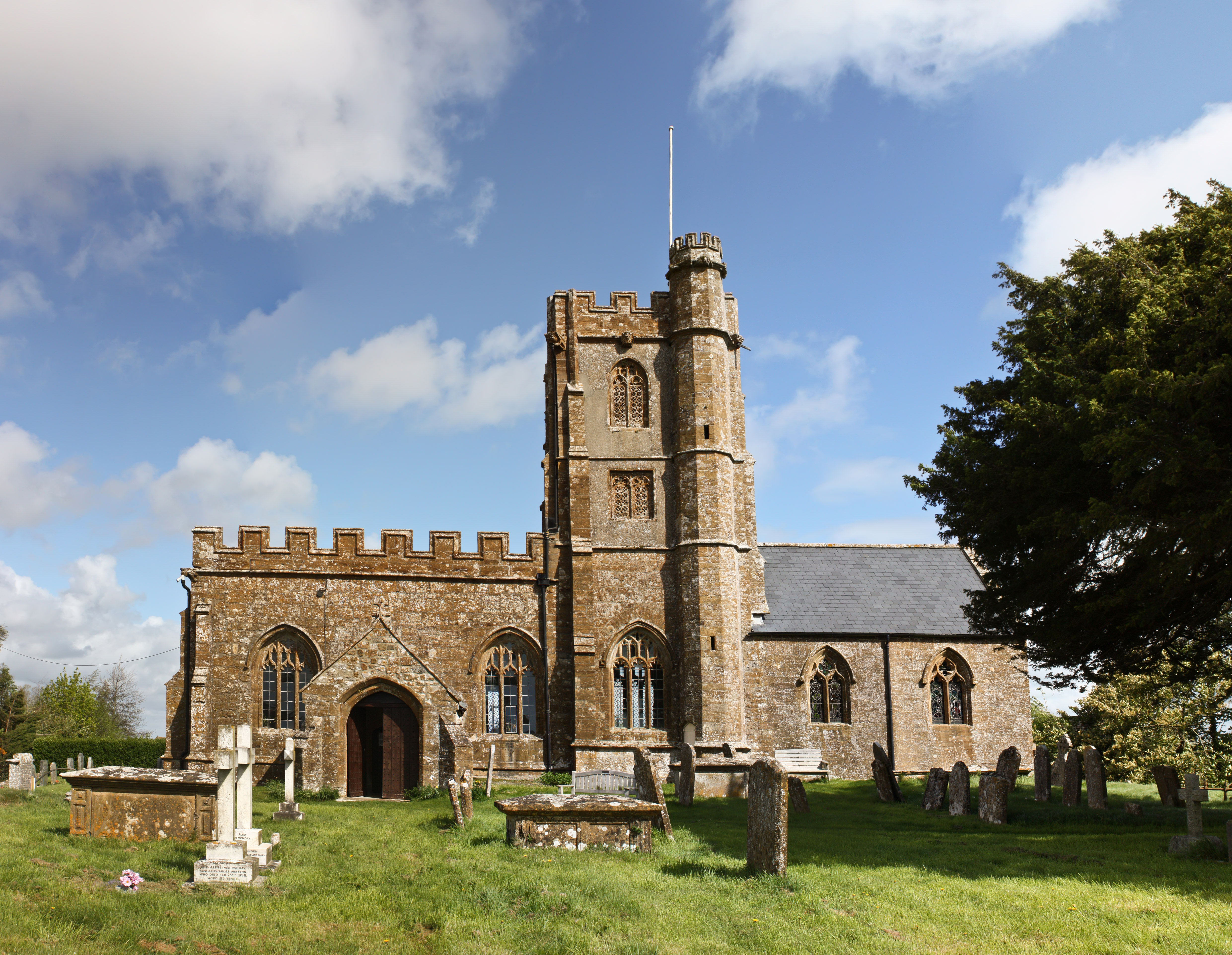
Church of St John the Evangelist and All Saints, Kingstone

The Anglican Church of St John the Evangelist and All Saints in Kingstone, Somerset, England was built in the 14th century. It is a Grade II* listed building...

Seavington St. Mary SSSI, Somerset

Seavington St. Mary (grid reference ST400144) is a 0.3 hectare geological Site of Special Scientific Interest near the village of Seavington St Mary in...

Church of St Nicholas, Dinnington

The Anglican Church of St Nicholas in Dinnington, Somerset, England was built in the 15th century. It is a Grade II* listed building. == History == A church...

Seavington St Mary

Seavington St Mary is a village and civil parish in Somerset, England. It is situated next to the village of Seavington St Michael, about 3 miles (4.8...

Kingstone, Somerset

Kingstone is a village and civil parish in Somerset, England, situated near Ilminster, 5 miles (8.0 km) north east of Chard in the South Somerset district...

Dinnington, Somerset

Dinnington is a village and civil parish in the English county of Somerset, situated 4 miles (6.4 km) north of Crewkerne in the South Somerset district...

Church of St Andrew, Dowlish Wake

The Anglican Church of St Andrew in Dowlish Wake, Somerset, England, was built in the 14th century. It is a Grade II* listed building. == History == The...

Dowlish Wake

Dowlish Wake is a small village and civil parish in Somerset, England, 2 miles (3 km) south of Ilminster and 5 miles (8 km) northeast of Chard in the South...

Nearby Amenities

Located within 500m of 50.916866,-2.867371
Allowenshay
Place: hamlet
Lat/Long: 50.9161609/-2.865179
Power: pole
Lat/Long: 50.9170955/-2.8607503
Power: pole
Lat/Long: 50.9168401/-2.8616917
Telephone
Defibrillator
Access: yes
Booth: K6
Covered: booth
Defibrillator Location: inside old red phone box, Castles Hill, Allowenshay
Emergency: defibrillator
Listed Status: Grade II
Ref GB The Circuit: 9816FFB7-C45A-477D-91FE-AE3100C15702
Lat/Long: 50.9157251/-2.8656883
Post Box
Post Box Type: wall
Lat/Long: 50.9160131/-2.8654687
The data included in this document is from www.openstreetmap.org. The data is made available under ODbL.

Have you been to Kingstone?

Leave your review of Kingstone below (or comments, questions and feedback).