Hoar Cross

Civil Parish in Staffordshire East Staffordshire

England

Hoar Cross

A healthy looking crop Looking across a field of wheat.
A healthy looking crop Credit: Malcolm Neal

Hoar Cross is a civil parish located in Staffordshire, England. It is situated in the East Staffordshire district, approximately 8 miles northeast of Burton upon Trent. This rural parish covers an area of approximately 4 square miles.

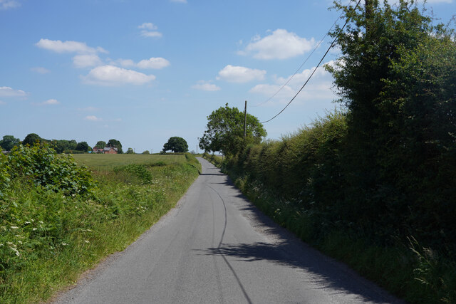
The village of Hoar Cross is the main settlement within the parish. It has a small population of around 200 residents. The village is known for its picturesque surroundings, with rolling countryside, woodlands, and the River Trent nearby.

One of the notable landmarks in Hoar Cross is the Hoar Cross Hall, a Grade II listed country house. Originally built in the 19th century, it has been converted into a luxury spa hotel and is a popular destination for relaxation and wellness retreats.

The parish also contains several farms and agricultural land, contributing to the rural character of the area. The agricultural activities primarily revolve around dairy farming and arable farming.

Hoar Cross is well-connected with neighboring areas via road networks, with the A515 running through the parish, providing easy access to Burton upon Trent and Lichfield. The nearest railway station is in Burton upon Trent, offering connections to major cities like Birmingham and Derby.

Overall, Hoar Cross is a tranquil and scenic civil parish in Staffordshire, offering a peaceful countryside retreat for residents and visitors alike.

If you have any feedback on the listing, please let us know in the comments section below.

Hoar Cross Images

Images are sourced within 2km of 52.805546/-1.814734 or Grid Reference SK1223. Thanks to Geograph Open Source API. All images are credited.

A healthy looking crop Looking across a field of wheat.
A healthy looking crop
Looking across a field of wheat.
Thorney Lanes Standing on a small triangle of grass looking along Thorney Lanes.
Thorney Lanes
Standing on a small triangle of grass looking along Thorney Lanes.
Thorney Lanes This is just before the junction with Abbots Bromley Road.
Thorney Lanes
This is just before the junction with Abbots Bromley Road.
Maker Lane The road surface on Maker Lane is very variable and in some places there are very deep potholes.
Maker Lane
The road surface on Maker Lane is very variable and in some places there are very deep potholes.
By Nicholls Covert The sign says "The Deer Park" but I think it is just a cafe and farm shop.
By Nicholls Covert
The sign says "The Deer Park" but I think it is just a cafe and farm shop.
Maker Lane Looking along Maker Lane.
Maker Lane
Looking along Maker Lane.
Yoxall Road This road has recently been tar sprayed and covered in limestone chippings and has a 10 MPH speed limit to prevent damage to the paintwork.
Yoxall Road
This road has recently been tar sprayed and covered in limestone chippings and has a 10 MPH speed limit to prevent damage to the paintwork.
Approaching Hoar Cross Further along Yoxall Road near the cross roads with Hoar Cross just visible, not that it is a very big place.
Approaching Hoar Cross
Further along Yoxall Road near the cross roads with Hoar Cross just visible, not that it is a very big place.
Brakenhurst Road With deep shadow on one side and bright sunlight on the other, the camera has coped with the difference quite well.
Brakenhurst Road
With deep shadow on one side and bright sunlight on the other, the camera has coped with the difference quite well.
Direction Sign - Signpost in Hoar Cross Located on the southwest side of the crossroads of Newborough Road, Abbots Bromley Road and Hoar Cross Road in Hoar Cross parish. 3 arms and perforated disc finial. See also <a title="https://www.geograph.org.uk/photo/3555123" href="https://www.geograph.org.uk/photo/3555123">Link</a>.

Milestone Society National ID: ST_SK1323
Direction Sign - Signpost in Hoar Cross
Located on the southwest side of the crossroads of Newborough Road, Abbots Bromley Road and Hoar Cross Road in Hoar Cross parish. 3 arms and perforated disc finial. See also Link. Milestone Society National ID: ST_SK1323
Woodland at Roost Hill It is interesting to contrast the attitude of private forestry operators (as here, no public access) with that of the Forestry Commission who regard public access and recreation as part of their responsibilities.
Woodland at Roost Hill
It is interesting to contrast the attitude of private forestry operators (as here, no public access) with that of the Forestry Commission who regard public access and recreation as part of their responsibilities.
The "Noon Column" Jackson's Bank This is one of six noon columns created by the sculptor David Nash, one being located in each of the six main areas of the National Forest. The column is so positioned that a thin pencil of light will pass through the slot at true noon. <span class="nowrap"><a title="http://www.landshapes.org/newsandevents/news/Physicalprojects.php" rel="nofollow ugc noopener" href="http://www.landshapes.org/newsandevents/news/Physicalprojects.php">Link</a><img style="margin-left:2px;" alt="External link" title="External link - shift click to open in new window" src="https://s1.geograph.org.uk/img/external.png" width="10" height="10"/></span>
The "Noon Column" Jackson's Bank
This is one of six noon columns created by the sculptor David Nash, one being located in each of the six main areas of the National Forest. The column is so positioned that a thin pencil of light will pass through the slot at true noon. LinkExternal link
Hoar Cross A traditional signpost, topped with the Staffordshire knot, stands at this cross-roads. The Menell Ingram Arms public house is partially hidden behind the tree.
Hoar Cross
A traditional signpost, topped with the Staffordshire knot, stands at this cross-roads. The Menell Ingram Arms public house is partially hidden behind the tree.
Hay meadow and hay bales Seen from the road between Hoar Cross and Newborough
Hay meadow and hay bales
Seen from the road between Hoar Cross and Newborough
Fields of maize near Newborough, Staffordshire. Fields of maize look remarkably healthy in the early evening sunshine, despite a heatwave and lack of rain over the previous few weeks! The view is from the B5234 looking south-west. The edge of Birch Wood is on the left and Barn Farm can be clearly seen on the ridge in the middle distance. The cooling towers of Rugeley Power Station can just be picked out in the far distance, with Cannock Chase beyond.
Fields of maize near Newborough, Staffordshire.
Fields of maize look remarkably healthy in the early evening sunshine, despite a heatwave and lack of rain over the previous few weeks! The view is from the B5234 looking south-west. The edge of Birch Wood is on the left and Barn Farm can be clearly seen on the ridge in the middle distance. The cooling towers of Rugeley Power Station can just be picked out in the far distance, with Cannock Chase beyond.
The drive to Bentilee Park farm
The end of the road, Rowley Farms From both 1:50000 and 1:25000, Rowley Farms appears to be a hamlet name.
The end of the road, Rowley Farms
From both 1:50000 and 1:25000, Rowley Farms appears to be a hamlet name.
Ladysmith Farm This farm stands in splendid isolation in the middle of its grid square at the end of a mile-long drive.
Ladysmith Farm
This farm stands in splendid isolation in the middle of its grid square at the end of a mile-long drive.
Show me another place!

Hoar Cross is located at Grid Ref: SK1223 (Lat: 52.805546, Lng: -1.814734)

Administrative County: Staffordshire

District: East Staffordshire

Police Authority: Staffordshire

What 3 Words

///speaking.hiker.line. Near Abbots Bromley, Staffordshire

Related Wikis

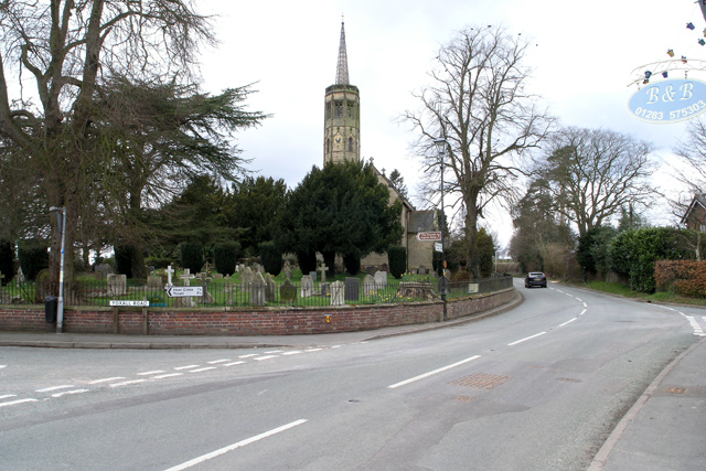
Church of the Holy Angels, Hoar Cross

The Church of the Holy Angels is an Anglican church in Hoar Cross, Staffordshire, England. It is a Grade I listed building. == History == It was built...
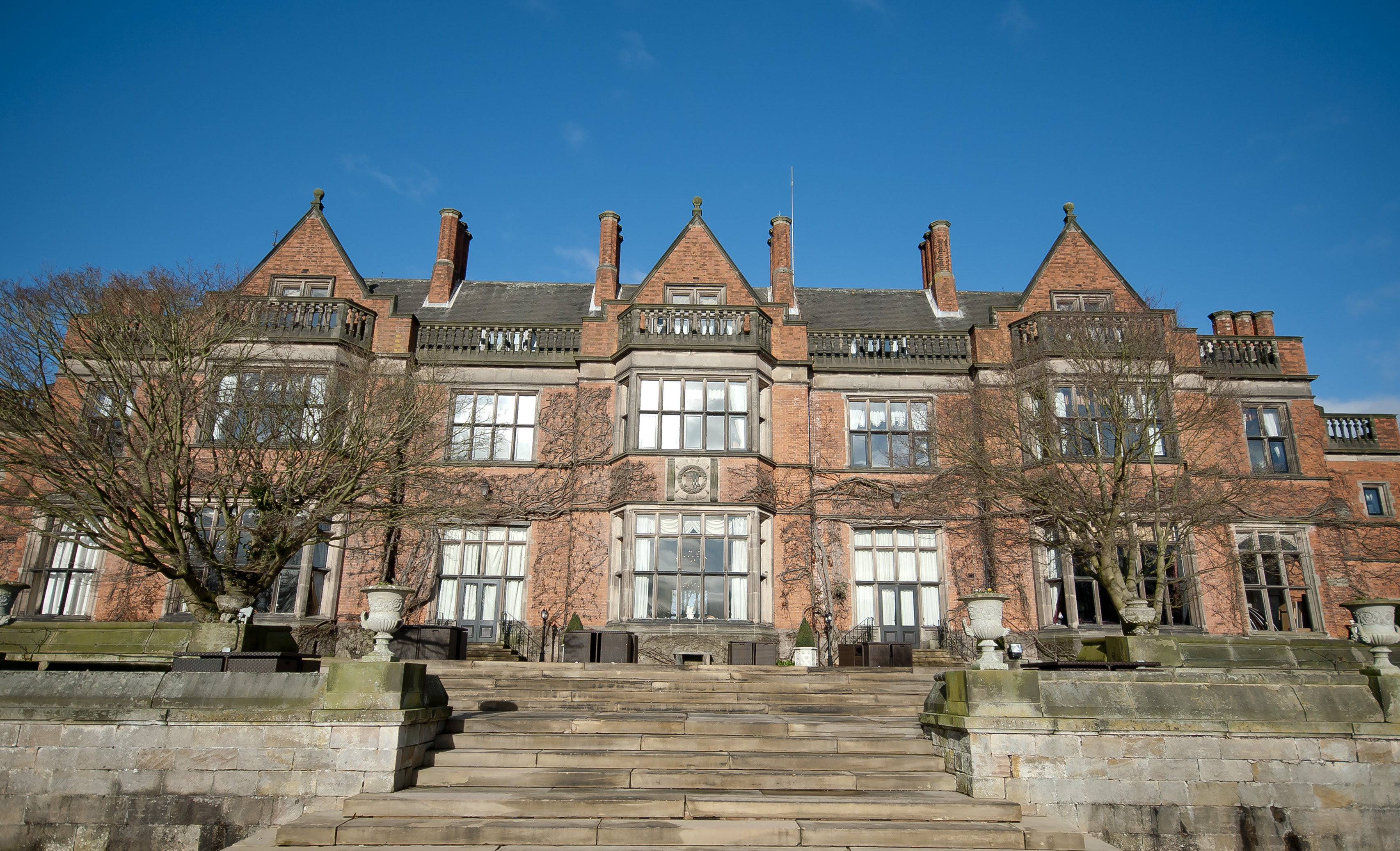
Hoar Cross Hall

Hoar Cross Hall is a 19th-century country mansion near the villages of Hoar Cross and Hamstall Ridware, Staffordshire. England. The Grade II listed building...

Hoar Cross

Hoar Cross is a small village and civil parish in the Borough of East Staffordshire, situated approximately 7 miles (11 km) west of Burton upon Trent....

Newborough, Staffordshire

Newborough is a village and civil parish in the county of Staffordshire, England. It is located 3 miles (5 km) south west of Hanbury and 8 miles (13 km...

Tatenhill Airfield

Tatenhill Airfield (ICAO: EGBM) is a licensed airfield operated by Tatenhill Aviation Ltd. Its CAA Ordinary Licence (Number P813) allows flights for the...

RAF Tatenhill

RAF Tatenhill is a former Royal Air Force satellite airfield in Tatenhill, Staffordshire, England, 4 NM (7.4 km; 4.6 mi) west of Burton on Trent. It was...

St George's Park National Football Centre

St George's Park (SGP) is the English Football Association's national football centre (NFC) built on a 330-acre (130 ha) site at Burton upon Trent, Staffordshire...

Byrkley Lodge

Byrkley Lodge was a country house and later racing horse stud farm, located close to Burton on Trent, Staffordshire. Demolished in 1953, its former grounds...

Nearby Amenities

Located within 500m of 52.805546,-1.814734
Post Box
Brand: Royal Mail
Brand Wikidata: Q638098
Brand Wikipedia: en:Royal Mail
Operator: Royal Mail
Operator Wikidata: Q638098
Ref: DE13 1220
Lat/Long: 52.8042937/-1.8162691
Hoar Cross Hall
Addr City: Burton-on-Trent
Addr Postcode: DE13 8QS
Addr Street: Maker Lane
Addr Village: Hoar Cross
Fhrs Id: 1248512
Tourism: hotel
Lat/Long: 52.8059201/-1.818873
The data included in this document is from www.openstreetmap.org. The data is made available under ODbL.

Have you been to Hoar Cross?

Leave your review of Hoar Cross below (or comments, questions and feedback).