Bronaber

Settlement in Merionethshire

Wales

Bronaber

Ordnance Survey Cut Mark This OS cut mark can be found on Jerusalem Cottage. It marks a point 185.002m above mean sea level.
Ordnance Survey Cut Mark Credit: Adrian Dust

Bronaber is a small village located in the county of Merionethshire, Wales. Situated in the southern part of Snowdonia National Park, it is surrounded by stunning natural beauty and offers a peaceful and idyllic setting. The village is nestled within the Gwynant Valley, at the foothills of the Rhinog Mountains.

Known for its picturesque landscape, Bronaber attracts nature lovers and outdoor enthusiasts alike. Hikers and walkers can explore the nearby trails and enjoy breathtaking views of the surrounding hills and valleys. The village is also close to Llyn Trawsfynydd, a large reservoir popular for fishing and boating activities.

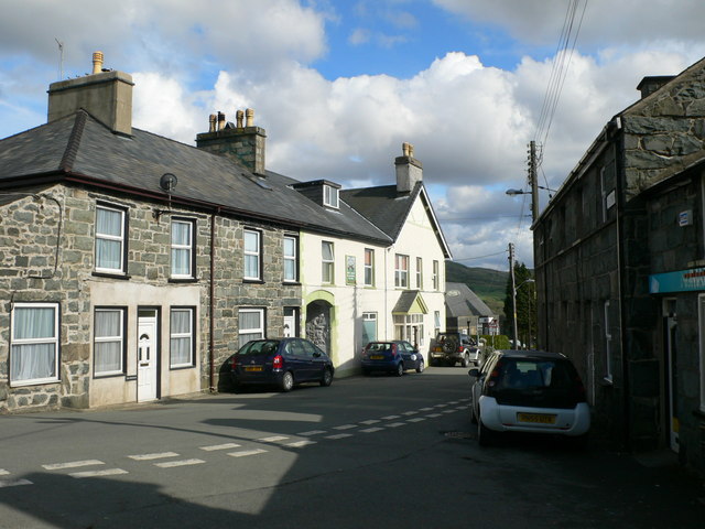
Bronaber itself is a small and quiet community, with a close-knit population. The village is predominantly residential, and the houses are mostly traditional stone cottages, adding to its charm and character. Amenities in Bronaber are limited, but nearby villages and towns provide essential services and facilities.

The area has a rich history, with evidence of human settlement dating back centuries. There are several ancient sites and landmarks in the vicinity, including standing stones and burial mounds. Visitors can also learn about the local history and culture by visiting the nearby heritage sites and museums.

Overall, Bronaber offers a tranquil and rural escape, providing an opportunity to immerse oneself in nature and experience the beauty of the Welsh countryside.

If you have any feedback on the listing, please let us know in the comments section below.

Bronaber Images

Images are sourced within 2km of 52.869037/-3.913191 or Grid Reference SH7131. Thanks to Geograph Open Source API. All images are credited.

Ordnance Survey Cut Mark This OS cut mark can be found on Jerusalem Cottage. It marks a point 185.002m above mean sea level.
Ordnance Survey Cut Mark
This OS cut mark can be found on Jerusalem Cottage. It marks a point 185.002m above mean sea level.
Ordnance Survey Cut Mark This OS cut mark can be found on the east face of St Tomas. It marks a point 212.395m above mean sea level.
Ordnance Survey Cut Mark
This OS cut mark can be found on the east face of St Tomas. It marks a point 212.395m above mean sea level.
Ordnance Survey Rivet This OS rivet can be found on the stone at the road junction. It marks a point 290.252m above mean sea level.
Ordnance Survey Rivet
This OS rivet can be found on the stone at the road junction. It marks a point 290.252m above mean sea level.
Ordnance Survey Rivet This OS rivet can be found on the culvert NE side of the road. It marks a point 325.828m above mean sea level.
Ordnance Survey Rivet
This OS rivet can be found on the culvert NE side of the road. It marks a point 325.828m above mean sea level.
Milestone - Dolgellau 11 <a title="https://www.geograph.org.uk/photo/7314123" href="https://www.geograph.org.uk/photo/7314123">Link</a>
Milestone - Dolgellau 11
Ordnance Survey Cut Mark This OS cut mark can be found on the milestone east side of the road. It marks a point 242.286m above mean sea level. <a title="https://www.geograph.org.uk/photo/7314122" href="https://www.geograph.org.uk/photo/7314122">Link</a>
Ordnance Survey Cut Mark
This OS cut mark can be found on the milestone east side of the road. It marks a point 242.286m above mean sea level. Link
The Nant Bryn-llefrith at Pont Faen This rather minor stream turns right (NNW) ahead, and drains into Llyn Trawsfynydd.

The northern end of the Rhinogs are seen, rather hazily, in the distance.
The Nant Bryn-llefrith at Pont Faen
This rather minor stream turns right (NNW) ahead, and drains into Llyn Trawsfynydd. The northern end of the Rhinogs are seen, rather hazily, in the distance.
The lane to Moel Gwynfynydd Like many lanes in this part of Wales, this is a cul-de-sac, at least for vehicles. The building in the middle distance is a chapel, though I do not know whether it is still in use as such.
The lane to Moel Gwynfynydd
Like many lanes in this part of Wales, this is a cul-de-sac, at least for vehicles. The building in the middle distance is a chapel, though I do not know whether it is still in use as such.
The lane to Trawsfynydd From here to the A470 at Trawsfynydd is just over 3 km (2 miles). You are advised not to use this lane unless you need access to somewhere along it, as it is very narrow, usually enclosed by hedges, and with very few passing places. Otherwise, the roads to the south and east of here can be much more easily reached from Bronaber through the Trawsfynydd Holiday Village.
The lane to Trawsfynydd
From here to the A470 at Trawsfynydd is just over 3 km (2 miles). You are advised not to use this lane unless you need access to somewhere along it, as it is very narrow, usually enclosed by hedges, and with very few passing places. Otherwise, the roads to the south and east of here can be much more easily reached from Bronaber through the Trawsfynydd Holiday Village.
Country near Trawsfynydd Holiday Village There is a convenient pub here (left of photo), but you need good navigation to find it!
Country near Trawsfynydd Holiday Village
There is a convenient pub here (left of photo), but you need good navigation to find it!
A minor road near Trawsfynydd Holiday Village
The A470 heading north Between Ganllwyd <a href="https://www.geograph.org.uk/gridref/SH7224">SH7224</a> and Trawsfynydd <a href="https://www.geograph.org.uk/photo/7135">NG8963 : On Drochaid a'Ghorm Locha</a> is one of the very few long, straight stretches of the A470. Although high speed is not recommended, this is one of the more tempting sections. Here the road is nearing the end of its long (200m+) but gentle climb from Dolgellau: over the brow ahead it remains almost level until the rather more messy descent to Ffestiniog.

The A470 is the main road running (roughly) north/south through mid-Wales, connecting Cardiff and Llandudno. In recent years the Welsh Assembly have clearly recognised its importance, as many of the worst sections have been significantly improved.
The A470 heading north
Between Ganllwyd SH7224 and Trawsfynydd NG8963 : On Drochaid a'Ghorm Locha is one of the very few long, straight stretches of the A470. Although high speed is not recommended, this is one of the more tempting sections. Here the road is nearing the end of its long (200m+) but gentle climb from Dolgellau: over the brow ahead it remains almost level until the rather more messy descent to Ffestiniog. The A470 is the main road running (roughly) north/south through mid-Wales, connecting Cardiff and Llandudno. In recent years the Welsh Assembly have clearly recognised its importance, as many of the worst sections have been significantly improved.
Capel Penystryd
Capel Penystryd
Ordnance Survey Cut Mark This OS cut mark can be found on the SE parapet of Pont-y-Grible. Under the date 1841.
Ordnance Survey Cut Mark
This OS cut mark can be found on the SE parapet of Pont-y-Grible. Under the date 1841.
The view from Pig Idris Looking towards Craiglaseithin [Crag of green gorse]. "Pig Idris" means "Idris's Point".
The view from Pig Idris
Looking towards Craiglaseithin [Crag of green gorse]. "Pig Idris" means "Idris's Point".
Looking down on the crossroads at Penystryd
Afon Eden
Afon Eden
Brick structure by Penystryd At first I thought an old bus shelter but that seemed unlikely on this remote road. However, it transpires that it is an old MOD police post to guard the ranges that existed hereabouts. Now has the mundane use of storing the rubbish bins!
Brick structure by Penystryd
At first I thought an old bus shelter but that seemed unlikely on this remote road. However, it transpires that it is an old MOD police post to guard the ranges that existed hereabouts. Now has the mundane use of storing the rubbish bins!
Show me another place!

Bronaber is located at Grid Ref: SH7131 (Lat: 52.869037, Lng: -3.913191)

Unitary Authority: Gwynedd

Police Authority: North Wales

What 3 Words

///refrain.stance.grinning. Near Bronaber, Gwynedd

Nearby Locations

Bronaber

Related Wikis

Bronaber

Bronaber is a village in Gwynedd, Wales, adjacent to the A470 north of Dolgellau and in Trawsfynydd community. == General information == During the Second...

Harlech Dome

The Harlech Dome is a geological dome in southern Snowdonia in north Wales. It extends approximately from Blaenau Ffestiniog in the north to Tywyn in the...

Moel Oernant

Moel Oernant is a 503-metre (1,650 ft) high hill in the community of Trawsfynydd in the county of Gwynedd in North Wales. It has a number of western tops...

Trawsfynydd

Trawsfynydd (Welsh pronunciation: [trausˈvənɨ̞ð]; Welsh for "across [the] mountain") is a linear village in Gwynedd, Wales, near Llyn Trawsfynydd reservoir...

Nearby Amenities

Located within 500m of 52.869037,-3.913191
Recycling
Recycling Cans: yes
Recycling Glass: yes
Recycling Paper: yes
Lat/Long: 52.8690909/-3.9112612
Addr Postcode: LL41 4YB
Fhrs Id: 330927
Operator: Trawsfynydd Holidays Limited
Shop: convenience
Lat/Long: 52.8694965/-3.9090159
Recycling
Recycling Type: container
Lat/Long: 52.8688716/-3.9078357
Hendre Fawr
Landuse: farm
Note Retag: CS #48756035
Lat/Long: 52.8727151/-3.9166457
Power: pole
Lat/Long: 52.8721893/-3.9184211
Power: pole
Lat/Long: 52.8714537/-3.917953
Material: wood
Power: pole
Lat/Long: 52.8707015/-3.9174504
Material: wood
Power: pole
Lat/Long: 52.8700158/-3.9169684
Power: pole
Lat/Long: 52.8692345/-3.9165071
Power: pole
Lat/Long: 52.8684532/-3.9159977
Power: pole
Lat/Long: 52.8668822/-3.9162937
Power: pole
Lat/Long: 52.8660343/-3.9164521
Material: wood
Power: pole
Lat/Long: 52.8653776/-3.916576
Power: pole
Lat/Long: 52.86509/-3.9156228
Bronaber
Place: village
Wikidata: Q15205023
Lat/Long: 52.869015/-3.9138677
Direction: 165
Generator Method: photovoltaic
Generator Output Electricity: yes
Generator Solar Modules: 10
Generator Source: solar
Generator Type: solar_photovoltaic_panel
Location: roof
Power: generator
Lat/Long: 52.8673916/-3.9071484
The data included in this document is from www.openstreetmap.org. The data is made available under ODbL.

Have you been to Bronaber?

Leave your review of Bronaber below (or comments, questions and feedback).