Heathylee

Civil Parish in Staffordshire Staffordshire Moorlands

England

Heathylee

Gritstone outcrop on the Roaches
Gritstone outcrop on the Roaches Credit: John H Darch

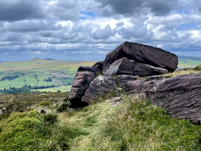
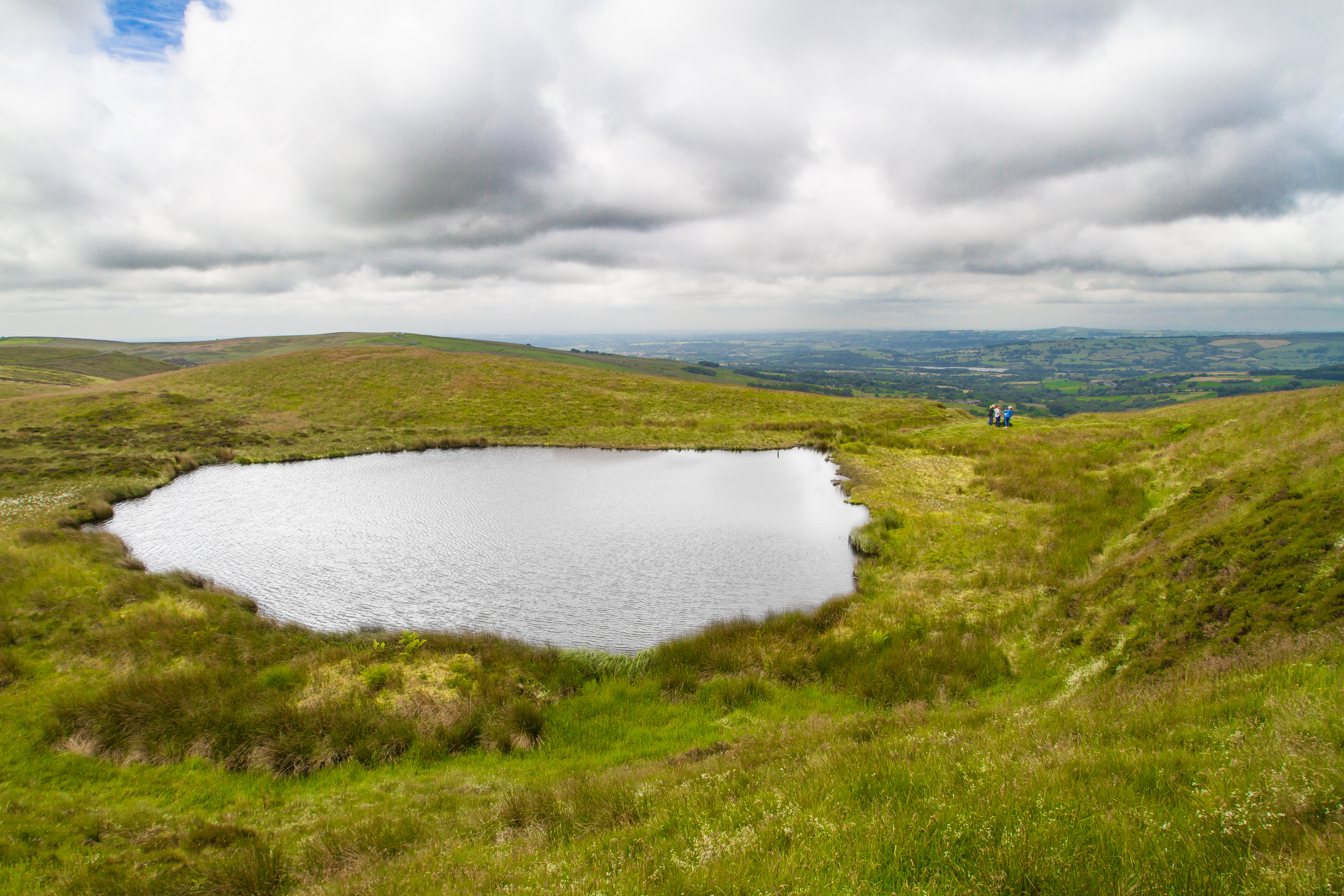
Heathylee is a civil parish located in the Staffordshire Moorlands district of Staffordshire, England. It is situated in the Peak District National Park, approximately 7 miles southeast of the town of Leek. The parish covers an area of around 4 square miles and is characterized by its picturesque rural landscapes and rolling hills.

The village of Heathylee itself is small and consists mainly of traditional stone-built houses and cottages. It is surrounded by open fields, woodlands, and moorlands, offering stunning views and opportunities for outdoor activities such as hiking, cycling, and birdwatching. The nearby Roaches, a prominent gritstone escarpment, attracts climbers from all over the country.

Despite its small size, Heathylee has a strong sense of community, with a close-knit population that actively participates in local events and initiatives. The parish has a local church, St. Bartholomew's, which holds regular services and community gatherings.

The area is known for its rich history, with evidence of ancient settlements and archaeological finds dating back to the Neolithic and Bronze Age periods. The Staffordshire Moorlands is also famous for its connections to the pottery industry, with several old kilns and remains of pottery factories scattered throughout the area.

Overall, Heathylee offers a tranquil and idyllic countryside setting, making it an attractive destination for those seeking a peaceful retreat or a base for exploring the beauty of the Peak District National Park.

If you have any feedback on the listing, please let us know in the comments section below.

Heathylee Images

Images are sourced within 2km of 53.168706/-1.973983 or Grid Reference SK0163. Thanks to Geograph Open Source API. All images are credited.

Gritstone outcrop on the Roaches
Blue Hills View from minor road towards a dwelling noted as Blue Hills on the map. Not to be confused with Bluehills Farm which is located on the other side of the road (not in picture). The sky matched the colour of the house on this sunny day,
Blue Hills
View from minor road towards a dwelling noted as Blue Hills on the map. Not to be confused with Bluehills Farm which is located on the other side of the road (not in picture). The sky matched the colour of the house on this sunny day,
View along track towards Hencow
View north from junction of tracks near Shawtop
Peak & Northern Footpaths Society, Sign No 582 Strrategically placed at junction of footpaths, Hen Cloud is visible beyond the sign.
Peak & Northern Footpaths Society, Sign No 582
Strrategically placed at junction of footpaths, Hen Cloud is visible beyond the sign.
Ramshaw Rocks The Churnet Way is visible passing below these unusual rock formations
Ramshaw Rocks
The Churnet Way is visible passing below these unusual rock formations
View south from footpath that ascends from Shawside to The Roaches
Footpath on The Roaches approaching Doxey Pool
Doxey Pool
Doxey Pool
Anvil Shaped Rock
Anvil Shaped Rock
Footpath approaching ruined barn near Naychurch
View from footpath, North of Naychurch
Ramshaw Rocks The southern end of the rocky ridge, overlooking the A53. Beloved by rock climbers
Ramshaw Rocks
The southern end of the rocky ridge, overlooking the A53. Beloved by rock climbers
Ramshaw Rocks Gritstone edge just west of the A53 near Upper Hulme. The Churnet Way, a 30 mile route, passes alongside the ridge on its way to Leek.
Ramshaw Rocks
Gritstone edge just west of the A53 near Upper Hulme. The Churnet Way, a 30 mile route, passes alongside the ridge on its way to Leek.
Churnet Way beside Ramshaw Rocks The Churnet Way, a 30 mile route, passes alongside the ridge on its way to Leek.
Churnet Way beside Ramshaw Rocks
The Churnet Way, a 30 mile route, passes alongside the ridge on its way to Leek.
Footpath sign near Ramshaw Rocks
Old barn near Naychurch
Rocky outcrop near Hen Cloud Cottage
Show me another place!

Heathylee is located at Grid Ref: SK0163 (Lat: 53.168706, Lng: -1.973983)

Administrative County: Staffordshire

District: Staffordshire Moorlands

Police Authority: Staffordshire

What 3 Words

///shackles.unpainted.geese. Near Leek, Staffordshire

Nearby Locations

Heathylee

Related Wikis

Black Brook Nature Reserve

Black Brook is a nature reserve of the Staffordshire Wildlife Trust, about 7 miles (11 km) north-east of Leek, in Staffordshire, England. It is moorland...

Heathylee

Heathylee is a civil parish in the district of Staffordshire Moorlands in north-east Staffordshire, England. There is no village centre. The parish has...

The Roaches

The Roaches (from the French les roches – the rocks) is a prominent rocky ridge above Leek and Tittesworth Reservoir in the Staffordshire Peak District...

Blakemere Pond

Blakemere Pond, also known as Black Mere Pool or Mermaid's Pond, is a small, natural lake in Staffordshire, England, six miles north-west of Leek. The...

Merryton Low

Merryton Low is a hill in Staffordshire, England, a few miles east of Leek. It is in the civil parish of Fawfieldhead in the local government district...

Leekfrith

Leekfrith is a civil parish in the Staffordshire Moorlands, in Staffordshire, England, north of the town of Leek. The population of the civil parish at...

Flash, Staffordshire

Flash is a village in the Staffordshire Moorlands, England, and Peak District National Park. At 1,519 feet (463 m) above sea level, it is the highest village...

Lud's Church

Lud's Church (sometimes written as Ludchurch) is a deep chasm penetrating the Millstone Grit bedrock created by a massive landslip on the hillside above...

Nearby Amenities

Located within 500m of 53.168706,-1.973983
Barrier: stile
Material: wood
Source: survey;gps
Stile: stepover
Lat/Long: 53.1682976/-1.9732312
Barrier: stile
Material: wood
Source: survey;gps
Stile: stepover
Lat/Long: 53.167269/-1.9730332
Barrier: stile
Lat/Long: 53.1670032/-1.9775972
Barrier: stile
Material: stone
Source: survey;gps
Stile: squeezer
Lat/Long: 53.1670862/-1.9776636
Barrier: stile
Material: wood
Source: survey;gps
Stile: stepover
Lat/Long: 53.1713563/-1.9763244
Barrier: stile
Material: wood
Source: survey;gps
Stile: stepover
Lat/Long: 53.169173/-1.9739456
Barrier: stile
Material: wood
Source: survey;gps
Stile: stepover
Lat/Long: 53.1665255/-1.9788808
Barrier: stile
Lat/Long: 53.1681526/-1.978827
Fixme: stile of gate?
Lat/Long: 53.1696969/-1.9766062
Barrier: stile
Material: wood
Source: survey;gps
Stile: stepover
Lat/Long: 53.1698645/-1.9760759
Fixme: Nov 2014. Obstructed by a new barbed wire fence.
Lat/Long: 53.1702163/-1.9807715
Barrier: stile
Material: stone
Source: survey;gps
Stile: stepover
Lat/Long: 53.1707222/-1.9759147
Barrier: stile
Lat/Long: 53.1662073/-1.9769751
The data included in this document is from www.openstreetmap.org. The data is made available under ODbL.

Have you been to Heathylee?

Leave your review of Heathylee below (or comments, questions and feedback).