Broadwas
Settlement in Worcestershire Malvern Hills
England
Broadwas

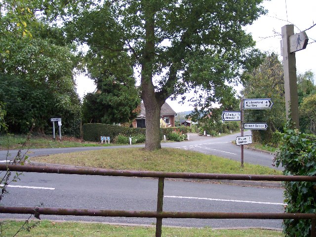
Broadwas is a small village located in the county of Worcestershire, England. Situated in the west of the county, it lies approximately 10 miles northwest of Worcester, the county town. The village is nestled in the beautiful countryside of the Malvern Hills Area of Outstanding Natural Beauty, providing residents and visitors with stunning views and a peaceful atmosphere.
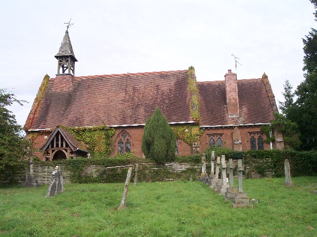
With a population of around 500 people, Broadwas boasts a close-knit community that takes pride in its rich history. The village is home to several historical landmarks, including St. Mary Magdalene Church, which dates back to the 12th century and features impressive Norman architecture.
Despite its small size, Broadwas offers a range of amenities to cater to its residents' needs. These include a primary school, a village hall, a pub, and a post office. The village also benefits from its proximity to the nearby city of Worcester, where residents can access a wider range of services and facilities.
The surrounding countryside provides ample opportunities for outdoor activities, with many scenic walking and cycling routes in the area. The nearby River Teme is also popular for fishing and boating enthusiasts. Additionally, the Malvern Hills, a short distance away, offer opportunities for hiking, picnicking, and enjoying panoramic views of the surrounding landscape.
Overall, Broadwas is a charming village that combines natural beauty, historical significance, and a strong sense of community, making it an appealing place to live or visit for those seeking a peaceful countryside retreat.
If you have any feedback on the listing, please let us know in the comments section below.
Broadwas Images
Images are sourced within 2km of 52.19822/-2.341561 or Grid Reference SO7655. Thanks to Geograph Open Source API. All images are credited.


Broadwas is located at Grid Ref: SO7655 (Lat: 52.19822, Lng: -2.341561)
Administrative County: Worcestershire
District: Malvern Hills
Police Authority: West Mercia
What 3 Words
///showdown.beaten.sunflower. Near Lower Broadheath, Worcestershire
Related Wikis
Broadwas
Broadwas, or Broadwas-on-Teme, is a village and civil parish (with Cotheridge) in the Malvern Hills district of Worcestershire, England. According to...

Cotheridge
Cotheridge is a village and civil parish in the district of Malvern Hills in the county of Worcestershire, England. It is 4 miles (6 km) west of the...

Cotheridge Court
Cotheridge Court is a Grade II* listed ancient manor house situated in the south-western part of Cotheridge, in the county of Worcestershire, England,...

Doddenham
Doddenham is a hamlet and civil parish (with Knightwick) in the Malvern Hills district in the county of Worcestershire, England. Doddenham was in the...

Stanford with Orleton
Stanford with Orleton is a civil parish in the Malvern Hills district, in the county of Worcestershire, England. The parish comprises the villages of Stanford...

Malvern Hills District
Malvern Hills is a local government district in Worcestershire, England. Its council is based in the town of Malvern, and its area covers most of the western...
St Leonard's Church, Cotheridge
St. Leonard's Church is a small, 12th-century church located in the scattered village of Cotheridge in Worcestershire. It stands not far from the manor...
Lulsley
Lulsley is a village and civil parish in the Malvern Hills District of the county of Worcestershire, England, UK. == History == Lulsley was in the upper...
Nearby Amenities
Located within 500m of 52.19822,-2.341561Have you been to Broadwas?
Leave your review of Broadwas below (or comments, questions and feedback).