Donington

Civil Parish in Lincolnshire South Holland

England

Donington

Donington South Ing
Donington South Ing Credit: Jonathan Thacker

Donington is a civil parish located in the county of Lincolnshire, in the East Midlands region of England. It is situated approximately 10 miles north of the town of Spalding and 14 miles east of the city of Peterborough. The village is nestled in the South Holland district and covers an area of around 5.5 square miles.

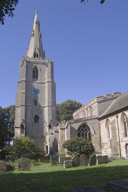
Donington is a predominantly agricultural community with a population of approximately 2,500 people. The village is known for its charming rural setting, characterized by picturesque farmlands, open fields, and quaint cottages. The historic St. Mary and the Holy Rood Church, dating back to the 13th century, stands as a prominent landmark in the area.

The village offers a range of amenities to its residents, including a primary school, a medical center, a post office, and several local shops and businesses. Donington also boasts a number of recreational facilities, such as a sports field, a community center, and a park.

Transportation in Donington is predominantly reliant on road networks, with the A152 road passing through the village, connecting it to neighboring towns and cities. Public bus services provide transportation links to nearby areas.

The community in Donington is vibrant and close-knit, with various social and cultural events taking place throughout the year. The village also has several community organizations and clubs, offering opportunities for residents to engage in various activities and interests.

In conclusion, Donington, Lincolnshire is a rural civil parish with a strong agricultural heritage, offering a peaceful and picturesque setting for its residents.

If you have any feedback on the listing, please let us know in the comments section below.

Donington Images

Images are sourced within 2km of 52.904641/-0.211466 or Grid Reference TF2035. Thanks to Geograph Open Source API. All images are credited.

Donington South Ing
Donington South Ing
Malting Lane level crossing Viewed looking towards Donington village on a bright late-August afternoon.
Malting Lane level crossing
Viewed looking towards Donington village on a bright late-August afternoon.
A blacksmith's grave at Donington Some old gravestones at Donington were made from a smooth, hard stone that has largely resisted weathering and so are still legible. The inscription reads:
SACRED
To the Memory of
JAMES NUNNERY.
Who departed this Life
April 22 1820
AGED 78 YEARS
Carved across the top are the symbols of the blacksmith’s trade – the forge, bellows, anvil and hammers.
A blacksmith's grave at Donington
Some old gravestones at Donington were made from a smooth, hard stone that has largely resisted weathering and so are still legible. The inscription reads: SACRED To the Memory of JAMES NUNNERY. Who departed this Life April 22 1820 AGED 78 YEARS Carved across the top are the symbols of the blacksmith’s trade – the forge, bellows, anvil and hammers.
Approaching Donington Church The bright flowers make a lovely approach to St. Mary and the Holy Rood Church in Donington village.
Approaching Donington Church
The bright flowers make a lovely approach to St. Mary and the Holy Rood Church in Donington village.
The A52 near Donington The main road passes by the village.
The A52 near Donington
The main road passes by the village.
Badgate Road Viewed at the junction with Quadring Road.
Badgate Road
Viewed at the junction with Quadring Road.
Mill Lane Housing on the outskirts of Donington village.
Mill Lane
Housing on the outskirts of Donington village.
High Street, Donington 'Duninctune' in the Doomsday Book. Possibly referring to a person (i.e. 'Dunna's settlement'), or a topographic term (i.e.' hill settlement' from OE 'dun' = 'hill') <span class="nowrap"><a title="http://kepn.nottingham.ac.uk/map/place/Lincolnshire/Donington%20on%20Bain" rel="nofollow ugc noopener" href="http://kepn.nottingham.ac.uk/map/place/Lincolnshire/Donington%20on%20Bain">Link</a><img style="margin-left:2px;" alt="External link" title="External link - shift click to open in new window" src="https://s1.geograph.org.uk/img/external.png" width="10" height="10"/></span> 
The Cross britain Way briefly visits this part of town
High Street, Donington
'Duninctune' in the Doomsday Book. Possibly referring to a person (i.e. 'Dunna's settlement'), or a topographic term (i.e.' hill settlement' from OE 'dun' = 'hill') LinkExternal link The Cross britain Way briefly visits this part of town
Church of St Mary and the Holy Rood, Donington Listed Grade I. For details <span class="nowrap"><a title="https://www.heritagesouthholland.co.uk/article/the-church-of-st-mary-and-the-holy-rood-donington/" rel="nofollow ugc noopener" href="https://www.heritagesouthholland.co.uk/article/the-church-of-st-mary-and-the-holy-rood-donington/">Link</a><img style="margin-left:2px;" alt="External link" title="External link - shift click to open in new window" src="https://s1.geograph.org.uk/img/external.png" width="10" height="10"/></span>
The church contains a small museum section, and a memorial window <a href="https://www.geograph.org.uk/photo/7260453">TF2035 : Flinders Memorial Window, Church of St Mary and the Holy Rood, Donington</a>, dedicated to Donington's famous son, Captain Matthew Flinders.
Church of St Mary and the Holy Rood, Donington
Listed Grade I. For details LinkExternal link The church contains a small museum section, and a memorial window TF2035 : Flinders Memorial Window, Church of St Mary and the Holy Rood, Donington, dedicated to Donington's famous son, Captain Matthew Flinders.
Flinders Memorial Window, Church of St Mary and the Holy Rood, Donington "The Flinders memorial window shows a full length figure of Matthew Flinders holding a telescope in the central window. Portrait medallion images of Joseph Banks and George Bass are to the left and right windows respectively. The lower part of the window shows a map of the south coast of Australia with HMS Investigator, the ship that Flinders captained on his circumnavigation." <span class="nowrap"><a title="https://heritage-explorer.lincolnshire.gov.uk/Monument/MLI22493" rel="nofollow ugc noopener" href="https://heritage-explorer.lincolnshire.gov.uk/Monument/MLI22493">Link</a><img style="margin-left:2px;" alt="External link" title="External link - shift click to open in new window" src="https://s1.geograph.org.uk/img/external.png" width="10" height="10"/></span> 
Flinders's remains, discovered by archaeologists during digging of the HS2 line near Euston Station, are due to be re-interred at this church in 2024, to commemorate the 250th anniversary year of his birth.
Flinders Memorial Window, Church of St Mary and the Holy Rood, Donington
"The Flinders memorial window shows a full length figure of Matthew Flinders holding a telescope in the central window. Portrait medallion images of Joseph Banks and George Bass are to the left and right windows respectively. The lower part of the window shows a map of the south coast of Australia with HMS Investigator, the ship that Flinders captained on his circumnavigation." LinkExternal link Flinders's remains, discovered by archaeologists during digging of the HS2 line near Euston Station, are due to be re-interred at this church in 2024, to commemorate the 250th anniversary year of his birth.
Bull's Bank, Donington South Ing
Station Street, Donington The original main road to the east before the bypass was built in 1990. The railway still operates, but the station closed in the 1960s.
Station Street, Donington
The original main road to the east before the bypass was built in 1990. The railway still operates, but the station closed in the 1960s.
Road junction at Donington Church Street veers off left from the A52. St Nary and the Holy Rood Church beyond the houses
Road junction at Donington
Church Street veers off left from the A52. St Nary and the Holy Rood Church beyond the houses
Donington: Crosslands
Donington: Crop
Donington: Crop
Donington: Crop
Donington: Crop
Donington Church Spire St Mary and the Holy Rood Church.
Donington Church Spire
St Mary and the Holy Rood Church.
Donington church The church, seldom open, contains an exhibition dedicated to Matthew Flinders, the first person to circumnavigate Australia. Some of his family are marked in the graves right foreground. His brother Sam, who survived him and accompanied him on the remarkable voyage, is buried on the north side.
Donington church
The church, seldom open, contains an exhibition dedicated to Matthew Flinders, the first person to circumnavigate Australia. Some of his family are marked in the graves right foreground. His brother Sam, who survived him and accompanied him on the remarkable voyage, is buried on the north side.
Show me another place!

Donington is located at Grid Ref: TF2035 (Lat: 52.904641, Lng: -0.211466)

Administrative County: Lincolnshire

District: South Holland

Police Authority: Lincolnshire

What 3 Words

///saying.encourage.recur. Near Donington, Lincolnshire

Related Wikis

Donington Road railway station

Donington Road railway station was a station in Lincolnshire on the line between Spalding and Sleaford. == References == == External links == Donington...

Cowley Academy

Cowley Academy (formally The Thomas Cowley High School) is a mixed secondary school with Academy status, in Donington, Lincolnshire, England. As of 1 September...

Donington, Lincolnshire

Donington is a large village and civil parish in the South Holland district of Lincolnshire, England. It is 8 miles (13 km) north from the market town...

Bicker Gauntlet

Bicker Gauntlet is a village in Lincolnshire, England. It is in the civil parish of Bicker. == External links == Media related to Bicker Gauntlet at Wikimedia...

Bicker, Lincolnshire

Bicker is a village in the Borough of Boston, Lincolnshire, England. The population of the village was 941 at the 2011 census. It is situated approximately...

Bicker Bar

Bicker Bar is a village in Lincolnshire, England. It is in the civil parish of Bicker == External links == Media related to Bicker Bar at Wikimedia Commons

Quadring

Quadring is a small village and civil parish in the South Holland district of Lincolnshire. It lies on the A152, 2 miles (3.2 km) north-east of Gosberton...

Quadring Fen

Quadring Fen is a hamlet in the South Holland district of Lincolnshire, England. It is situated 2 miles (3.2 km) south from the A52 road, 5 miles (8.0...

Nearby Amenities

Located within 500m of 52.904641,-0.211466
Donington
Is In: Lincolnshire, England, UK
Place: village
Wikidata: Q1241544
Wikipedia: en:Donington, Lincolnshire
Lat/Long: 52.9046401/-0.206098
Pub
The Black Bull
Addr City: Spalding
Addr Country: GB
Addr Housenumber: 7
Addr Postcode: PE11 4ST
Addr Street: Market Place
Addr Suburb: Donington
Fhrs Authority: South Holland
Fhrs Id: 243608
Fhrs Local Authority Id: 12374
Lat/Long: 52.9048158/-0.2051086
Bus Stop
Barnes Road
Bus: yes
Naptan AtcoCode: 270000008887
Naptan Bearing: NE
Naptan CommonName: Barnes Road
Naptan Indicator: NE - bound
Naptan Landmark: Barnes Road
Naptan NaptanCode: lingwgaw
Naptan Street: Station Road
Naptan Verified: no
Public Transport: platform
Source: naptan_import
Lat/Long: 52.9030601/-0.2140339
Bus Stop
Barnes Road
Bus: yes
Naptan AtcoCode: 270000008888
Naptan Bearing: SW
Naptan CommonName: Barnes Road
Naptan Indicator: SW - bound
Naptan Landmark: Barnes Road
Naptan NaptanCode: lingwgda
Naptan Street: Station Road
Naptan Verified: no
Public Transport: platform
Source: naptan_import
Lat/Long: 52.9028364/-0.2141025
Bus Stop
The Queen PH
Bus: yes
Naptan AtcoCode: 270000008889
Naptan Bearing: NE
Naptan CommonName: The Queen PH
Naptan Indicator: adj
Naptan Landmark: The Queen PH
Naptan NaptanCode: lingwgdg
Naptan Street: Station Street
Naptan Verified: no
Public Transport: platform
Source: naptan_import
Lat/Long: 52.9045198/-0.2088734
Bus Stop
The Queen PH
Bus: yes
Naptan AtcoCode: 270000008890
Naptan Bearing: SW
Naptan CommonName: The Queen PH
Naptan Indicator: opp
Naptan Landmark: The Queen PH
Naptan NaptanCode: lingwgdj
Naptan Street: Station Street
Naptan Verified: no
Public Transport: platform
Source: naptan_import
Lat/Long: 52.9043662/-0.2088203
Bus Stop
Market Place
Bus: yes
Naptan AtcoCode: 270000008891
Naptan Bearing: SW
Naptan CommonName: Market Place
Naptan Indicator: opp
Naptan Landmark: Market Place
Naptan NaptanCode: lingwgdm
Naptan Street: High Street
Naptan Verified: no
Public Transport: platform
Source: naptan_import
Lat/Long: 52.9050134/-0.2046448
Bus Stop
Market Place
Bus: yes
Naptan AtcoCode: 2700LDMP2881
Naptan Bearing: E
Naptan CommonName: Market Place
Naptan Indicator: adj
Naptan Landmark: Market Place
Naptan Street: High Street
Naptan Verified: no
Public Transport: platform
Source: naptan_import
Lat/Long: 52.9052147/-0.2042796
The Queen Inn
Disused Amenity: pub
Source: Bing
Lat/Long: 52.9046315/-0.2089577
Fast Food
Flinders
Addr City: Spalding
Addr Country: GB
Addr Housenumber: 4
Addr Postcode: PE11 4ST
Addr Street: Market Place
Addr Suburb: Donington
Cuisine: bavarian
Fhrs Authority: South Holland
Fhrs Id: 1392310
Fhrs Local Authority Id: 37135
Source: Bing
Lat/Long: 52.9049869/-0.2045094
Fen End
Place: locality
Source: Bing
Lat/Long: 52.902194/-0.2110663
Park Farm
Place: farm
Source: Bing
Lat/Long: 52.9029812/-0.2169263
Fast Food
Sunlight Chinese Takeaway
Addr City: Spalding
Addr Country: GB
Addr Housenumber: 1
Addr Postcode: PE11 4ST
Addr Street: Market Place
Addr Suburb: Donington
Cuisine: chinese
Delivery: no
Drive Through: no
Fhrs Authority: South Holland
Fhrs Id: 243035
Fhrs Local Authority Id: 27829
Outdoor Seating: no
Phone: +44 1775 822700
Lat/Long: 52.9050779/-0.2042408
Artwork Type: statue
Tourism: artwork
Lat/Long: 52.9050087/-0.2051253
Social Facility
Genesis Residential Home
Addr City: Spalding
Addr Country: GB
Addr Housenumber: 2
Addr Postcode: PE11 4UQ
Addr Street: Station Street
Addr Suburb: Donington
Fhrs Authority: South Holland
Fhrs Id: 243188
Fhrs Local Authority Id: 14407
Social Facility: assisted_living
Social Facility For: senior
Lat/Long: 52.9046945/-0.2056503
Fast Food
Seng House Chinese
Addr City: Spalding
Addr Country: GB
Addr Housenumber: 25
Addr Postcode: PE11 4ST
Addr Street: Market Place
Addr Suburb: Donington
Fhrs Authority: South Holland
Fhrs Id: 704539
Fhrs Local Authority Id: 36787
Lat/Long: 52.9052672/-0.2048001
Pharmacy
Lincolnshire Co-op Pharmacy
Addr City: Spalding
Addr Country: GB
Addr Housenumber: 27
Addr Postcode: PE11 4ST
Addr Street: Market Place
Addr Suburb: Donington
Dispensing: yes
Healthcare: pharmacy
Operator: Lincolnshire Co-op
Lat/Long: 52.9052494/-0.2049288
Jessops Bakers
Addr City: Spalding
Addr Country: GB
Addr Housenumber: 16
Addr Postcode: PE11 4ST
Addr Street: Market Place
Addr Suburb: Donington
Fhrs Authority: South Holland
Fhrs Id: 243261
Fhrs Local Authority Id: 431
Shop: bakery
Lat/Long: 52.9054289/-0.2050468
Get A Head
Shop: hairdresser
Lat/Long: 52.9053594/-0.2052292
Toilets
Access: yes
Changing Table: yes
Description: no toilet paper and no soap in male toilet on 2023-05-01
Fee: no
Female: yes
Male: yes
Lat/Long: 52.9053125/-0.2059534
Tulipland Foods
Addr City: Spalding
Addr Country: GB
Addr Housenumber: 11
Addr Postcode: PE11 4ST
Addr Street: Market Place
Addr Suburb: Donington
Fhrs Authority: South Holland
Fhrs Id: 242966
Fhrs Local Authority Id: 18455
Shop: butcher
Lat/Long: 52.9051361/-0.205653
Coversure Insurance
Office: insurance
Lat/Long: 52.9052348/-0.2042583
Pets and Produce
Addr City: Spalding
Addr Country: GB
Addr Housenumber: 4
Addr Postcode: PE11 4TA
Addr Street: High Street
Addr Suburb: Donington
Fhrs Authority: South Holland
Fhrs Id: 595993
Fhrs Local Authority Id: 36373
Shop: pet
Lat/Long: 52.9052267/-0.204092
Generator Method: photovoltaic
Generator Output Electricity: yes
Generator Source: solar
Generator Type: solar_photovoltaic_panel
Location: roof
Power: generator
Lat/Long: 52.901326/-0.2157125
Generator Method: photovoltaic
Generator Output Electricity: yes
Generator Source: solar
Generator Type: solar_photovoltaic_panel
Location: roof
Power: generator
Lat/Long: 52.9013519/-0.2156106
Generator Method: photovoltaic
Generator Output Electricity: yes
Generator Source: solar
Generator Type: solar_photovoltaic_panel
Location: roof
Power: generator
Lat/Long: 52.901394/-0.2154872
Generator Method: photovoltaic
Generator Output Electricity: yes
Generator Source: solar
Generator Type: solar_photovoltaic_panel
Location: roof
Power: generator
Lat/Long: 52.9014134/-0.2153799
Generator Method: photovoltaic
Generator Output Electricity: yes
Generator Source: solar
Generator Type: solar_photovoltaic_panel
Location: roof
Power: generator
Lat/Long: 52.9015606/-0.2152351
Generator Method: photovoltaic
Generator Output Electricity: yes
Generator Source: solar
Generator Type: solar_photovoltaic_panel
Location: roof
Power: generator
Lat/Long: 52.9015703/-0.2151493
Generator Method: photovoltaic
Generator Output Electricity: yes
Generator Source: solar
Generator Type: solar_photovoltaic_panel
Location: roof
Power: generator
Lat/Long: 52.9015121/-0.2152217
Generator Method: photovoltaic
Generator Output Electricity: yes
Generator Source: solar
Generator Type: solar_photovoltaic_panel
Location: roof
Power: generator
Lat/Long: 52.9015169/-0.2151546
Generator Method: photovoltaic
Generator Output Electricity: yes
Generator Source: solar
Generator Type: solar_photovoltaic_panel
Location: roof
Power: generator
Lat/Long: 52.9013649/-0.2146879
Generator Method: photovoltaic
Generator Output Electricity: yes
Generator Source: solar
Generator Type: solar_photovoltaic_panel
Location: roof
Power: generator
Lat/Long: 52.9013681/-0.2146075
Generator Method: photovoltaic
Generator Output Electricity: yes
Generator Source: solar
Generator Type: solar_photovoltaic_panel
Location: roof
Power: generator
Lat/Long: 52.9016027/-0.2148113
Generator Method: photovoltaic
Generator Output Electricity: yes
Generator Source: solar
Generator Type: solar_photovoltaic_panel
Location: roof
Power: generator
Lat/Long: 52.9017434/-0.214578
Generator Method: photovoltaic
Generator Output Electricity: yes
Generator Source: solar
Generator Type: solar_photovoltaic_panel
Location: roof
Power: generator
Lat/Long: 52.9009119/-0.2117134
Generator Method: photovoltaic
Generator Output Electricity: yes
Generator Source: solar
Generator Type: solar_photovoltaic_panel
Location: roof
Power: generator
Lat/Long: 52.9008924/-0.211413
Generator Method: photovoltaic
Generator Output Electricity: yes
Generator Source: solar
Generator Type: solar_photovoltaic_panel
Location: roof
Power: generator
Lat/Long: 52.9011141/-0.2097205
Generator Method: photovoltaic
Generator Output Electricity: yes
Generator Source: solar
Generator Type: solar_photovoltaic_panel
Location: roof
Power: generator
Lat/Long: 52.9016609/-0.2079073
Generator Method: photovoltaic
Generator Output Electricity: yes
Generator Source: solar
Generator Type: solar_photovoltaic_panel
Location: roof
Power: generator
Lat/Long: 52.9019513/-0.2075948
Generator Method: photovoltaic
Generator Output Electricity: yes
Generator Source: solar
Generator Type: solar_photovoltaic_panel
Location: roof
Power: generator
Lat/Long: 52.9036412/-0.2042381
Generator Method: photovoltaic
Generator Output Electricity: yes
Generator Source: solar
Generator Type: solar_photovoltaic_panel
Location: roof
Power: generator
Lat/Long: 52.9039211/-0.207151
Generator Method: photovoltaic
Generator Output Electricity: yes
Generator Source: solar
Generator Type: solar_photovoltaic_panel
Location: roof
Power: generator
Lat/Long: 52.9039825/-0.2073977
Generator Method: photovoltaic
Generator Output Electricity: yes
Generator Source: solar
Generator Type: solar_photovoltaic_panel
Location: roof
Power: generator
Lat/Long: 52.9039712/-0.2074943
Generator Method: photovoltaic
Generator Output Electricity: yes
Generator Source: solar
Generator Type: solar_photovoltaic_panel
Location: roof
Power: generator
Lat/Long: 52.9033387/-0.2081756
Generator Method: photovoltaic
Generator Output Electricity: yes
Generator Source: solar
Generator Type: solar_photovoltaic_panel
Location: roof
Power: generator
Lat/Long: 52.903735/-0.2104554
Generator Method: photovoltaic
Generator Output Electricity: yes
Generator Source: solar
Generator Type: solar_photovoltaic_panel
Location: roof
Power: generator
Lat/Long: 52.9046685/-0.2079637
Generator Method: photovoltaic
Generator Output Electricity: yes
Generator Source: solar
Generator Type: solar_photovoltaic_panel
Location: roof
Power: generator
Lat/Long: 52.9046717/-0.2078805
Generator Method: photovoltaic
Generator Output Electricity: yes
Generator Source: solar
Generator Type: solar_photovoltaic_panel
Location: roof
Power: generator
Lat/Long: 52.904717/-0.2075855
Generator Method: photovoltaic
Generator Output Electricity: yes
Generator Source: solar
Generator Type: solar_photovoltaic_panel
Location: roof
Power: generator
Lat/Long: 52.9059788/-0.2085511
Generator Method: photovoltaic
Generator Output Electricity: yes
Generator Source: solar
Generator Type: solar_photovoltaic_panel
Location: roof
Power: generator
Lat/Long: 52.9059885/-0.2084894
Generator Method: photovoltaic
Generator Output Electricity: yes
Generator Source: solar
Generator Type: solar_photovoltaic_panel
Location: roof
Power: generator
Lat/Long: 52.9062409/-0.2068398
Generator Method: photovoltaic
Generator Output Electricity: yes
Generator Source: solar
Generator Type: solar_photovoltaic_panel
Location: roof
Power: generator
Lat/Long: 52.9057356/-0.205094
Generator Method: photovoltaic
Generator Output Electricity: yes
Generator Source: solar
Generator Type: solar_photovoltaic_panel
Location: roof
Power: generator
Lat/Long: 52.9057439/-0.2050551
Give Way
Direction: forward
Lat/Long: 52.9049451/-0.2053173
The data included in this document is from www.openstreetmap.org. The data is made available under ODbL.

Have you been to Donington?

Leave your review of Donington below (or comments, questions and feedback).