Chaceley

Civil Parish in Worcestershire Tewkesbury

England

Chaceley

Wigwood Farm, Tirley I was passing this farmhouse on the 17th anniversary of first photographing it for Geograph in 2005 <a href="https://www.geograph.org.uk/photo/49227">SO8429 : Wigwood Farm, Tirley</a>, it has changed a little in the intervening years and the pond in the foreground is showing the effects of this year's dry summer.  The farmhouse is Grade II listed, see: <span class="nowrap"><a title="https://historicengland.org.uk/listing/the-list/list-entry/1091381" rel="nofollow ugc noopener" href="https://historicengland.org.uk/listing/the-list/list-entry/1091381">Link</a><img style="margin-left:2px;" alt="External link" title="External link - shift click to open in new window" src="https://s1.geograph.org.uk/img/external.png" width="10" height="10"/></span>  I previously photographed this farmhouse just under two years ago <a href="https://www.geograph.org.uk/photo/6682714">SO8429 : Wigwood Farm, Tirley</a>.
Wigwood Farm, Tirley Credit: Philip Halling

Chaceley is a small civil parish located in Worcestershire, England. Situated about 5 miles northwest of the city of Gloucester, it is nestled within the beautiful countryside of the Severn Vale. The parish covers an area of approximately 2 square miles and is home to a population of around 150 people.

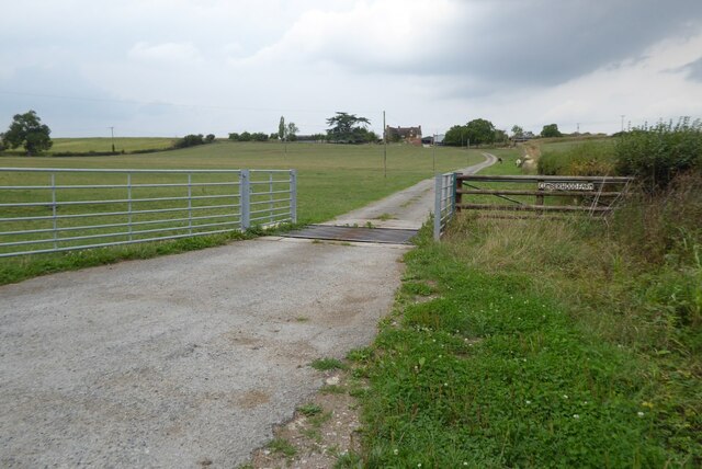
Chaceley is known for its idyllic rural setting, with rolling hills, lush green fields, and picturesque views. The River Severn flows nearby, offering a scenic backdrop and recreational opportunities such as fishing and boating. The parish is largely agricultural, with farming being the main industry.

The village itself is small and charming, with a handful of traditional stone cottages and a historic church, St. John the Baptist, dating back to the 12th century. The church is a Grade II* listed building and is known for its Norman architecture and beautiful stained glass windows.

Chaceley is a close-knit community, with residents enjoying a peaceful and tranquil lifestyle. There are no shops or amenities within the parish, but the nearby towns of Tewkesbury and Worcester offer a range of services and facilities.

The area is also rich in wildlife, with numerous nature reserves and bird sanctuaries in the surrounding countryside. Chaceley is a popular destination for nature lovers and birdwatchers, providing opportunities to spot a variety of species in their natural habitat.

Overall, Chaceley is a charming and serene parish, offering a slice of rural paradise in Worcestershire.

If you have any feedback on the listing, please let us know in the comments section below.

Chaceley Images

Images are sourced within 2km of 51.977092/-2.221163 or Grid Reference SO8430. Thanks to Geograph Open Source API. All images are credited.

Wigwood Farm, Tirley I was passing this farmhouse on the 17th anniversary of first photographing it for Geograph in 2005 <a href="https://www.geograph.org.uk/photo/49227">SO8429 : Wigwood Farm, Tirley</a>, it has changed a little in the intervening years and the pond in the foreground is showing the effects of this year's dry summer.  The farmhouse is Grade II listed, see: <span class="nowrap"><a title="https://historicengland.org.uk/listing/the-list/list-entry/1091381" rel="nofollow ugc noopener" href="https://historicengland.org.uk/listing/the-list/list-entry/1091381">Link</a><img style="margin-left:2px;" alt="External link" title="External link - shift click to open in new window" src="https://s1.geograph.org.uk/img/external.png" width="10" height="10"/></span>  I previously photographed this farmhouse just under two years ago <a href="https://www.geograph.org.uk/photo/6682714">SO8429 : Wigwood Farm, Tirley</a>.
Wigwood Farm, Tirley
I was passing this farmhouse on the 17th anniversary of first photographing it for Geograph in 2005 SO8429 : Wigwood Farm, Tirley, it has changed a little in the intervening years and the pond in the foreground is showing the effects of this year's dry summer. The farmhouse is Grade II listed, see: LinkExternal link I previously photographed this farmhouse just under two years ago SO8429 : Wigwood Farm, Tirley.
Town Street, Tirley A country road passing through Town Street in Tirley.  Chippings has been spread on the road recently and there is currently a 20MPH speed limit in place. A similar view to that captured by Jonathan in 2010 <a href="https://www.geograph.org.uk/photo/1959514">SO8429 : Town Street, Tirley</a>.
Town Street, Tirley
A country road passing through Town Street in Tirley. Chippings has been spread on the road recently and there is currently a 20MPH speed limit in place. A similar view to that captured by Jonathan in 2010 SO8429 : Town Street, Tirley.
Great Cumberwood Farm Entrance to Great Cumberwood Farm in Tirley.
Great Cumberwood Farm
Entrance to Great Cumberwood Farm in Tirley.
Country road near Chaceley (1) Heading north east towards Chaceley.
Country road near Chaceley (1)
Heading north east towards Chaceley.
The Yew Tree Inn, Chaceley Stock Played skittles here in the opening game of the Tewkesbury Skittles League season last Wednesday night (we won by 19, I scored 53 in eight hands) and thought I would have a walk here this afternoon.  Since photographing the pub from across the river in December 2007 <a href="https://www.geograph.org.uk/photo/642986">SO8629 : The Yew Tree, Chaceley Stock</a> it has been repainted.
The Yew Tree Inn, Chaceley Stock
Played skittles here in the opening game of the Tewkesbury Skittles League season last Wednesday night (we won by 19, I scored 53 in eight hands) and thought I would have a walk here this afternoon. Since photographing the pub from across the river in December 2007 SO8629 : The Yew Tree, Chaceley Stock it has been repainted.
The Yew Tree Inn, Chaceley Stock The car park to the Yew Tree Inn at Chaceley Stock.
The Yew Tree Inn, Chaceley Stock
The car park to the Yew Tree Inn at Chaceley Stock.
Flood depth marker, Chaceley Stock Being on the banks of the River Severn Chaceley Stock is often flooded and sometimes featured on the regional news as being accessible only by boat.
Flood depth marker, Chaceley Stock
Being on the banks of the River Severn Chaceley Stock is often flooded and sometimes featured on the regional news as being accessible only by boat.
Road to Chaceley Stock Road to Chaceley Stock from Chaceley.  This road is in the middle of the broad Severn floodplain and is often flooded to a considerable depth.
Road to Chaceley Stock
Road to Chaceley Stock from Chaceley. This road is in the middle of the broad Severn floodplain and is often flooded to a considerable depth.
Tirley Street to Town Street This lane descends to the Severn flood plain here.
Tirley Street to Town Street
This lane descends to the Severn flood plain here.
Wigwood & Town Street Farms, Tirley
Path towards Little Sandpits Farm
Sheep and Great Cumberwood Farm
Grass field and willow trees near Tirley
Grass field near Great Cumberwood Farm Corse Grove in the distance.
Grass field near Great Cumberwood Farm
Corse Grove in the distance.
Great Cumberwood Entrance to Great Cumberwood Farm viewed from the passing country road.
Great Cumberwood
Entrance to Great Cumberwood Farm viewed from the passing country road.
Wigwood Farm, Tirley I first photographed this farmhouse for Geograph fifteen years ago in 2005 <a href="https://www.geograph.org.uk/photo/49227">SO8429 : Wigwood Farm, Tirley</a>, it's changed since then with the pond cleared of growth and some trees and creeper cut down.  The farmhouse is Grade II listed, see: <span class="nowrap"><a title="https://historicengland.org.uk/listing/the-list/list-entry/1091381" rel="nofollow ugc noopener" href="https://historicengland.org.uk/listing/the-list/list-entry/1091381">Link</a><img style="margin-left:2px;" alt="External link" title="External link - shift click to open in new window" src="https://s1.geograph.org.uk/img/external.png" width="10" height="10"/></span>
Wigwood Farm, Tirley
I first photographed this farmhouse for Geograph fifteen years ago in 2005 SO8429 : Wigwood Farm, Tirley, it's changed since then with the pond cleared of growth and some trees and creeper cut down. The farmhouse is Grade II listed, see: LinkExternal link
Cider press Cider press at Wigwood Farm.
Cider press
Cider press at Wigwood Farm.
Cumberwood Farm Cumberwood Farm near Tirley.
Cumberwood Farm
Cumberwood Farm near Tirley.
Show me another place!

Chaceley is located at Grid Ref: SO8430 (Lat: 51.977092, Lng: -2.221163)

Administrative County: Gloucestershire

District: Tewkesbury

Police Authority: Gloucestershire

What 3 Words

///handbag.sprouting.beeline. Near Tewkesbury, Gloucestershire

Related Wikis

Chaceley Meadow SSSI

Chaceley Meadow (grid reference SO857306) is a 1.8-hectare (4.4-acre) biological Site of Special Scientific Interest in Gloucestershire, notified in 1954...

Chaceley

Chaceley or Chaseley is a village and civil parish 8 miles (13 km) north of Gloucester, in the Tewkesbury district, in the county of Gloucestershire, England...

Forthampton

Forthampton is a village in Gloucestershire, England. The village is located three miles from the market town of Tewkesbury and features "a great number...
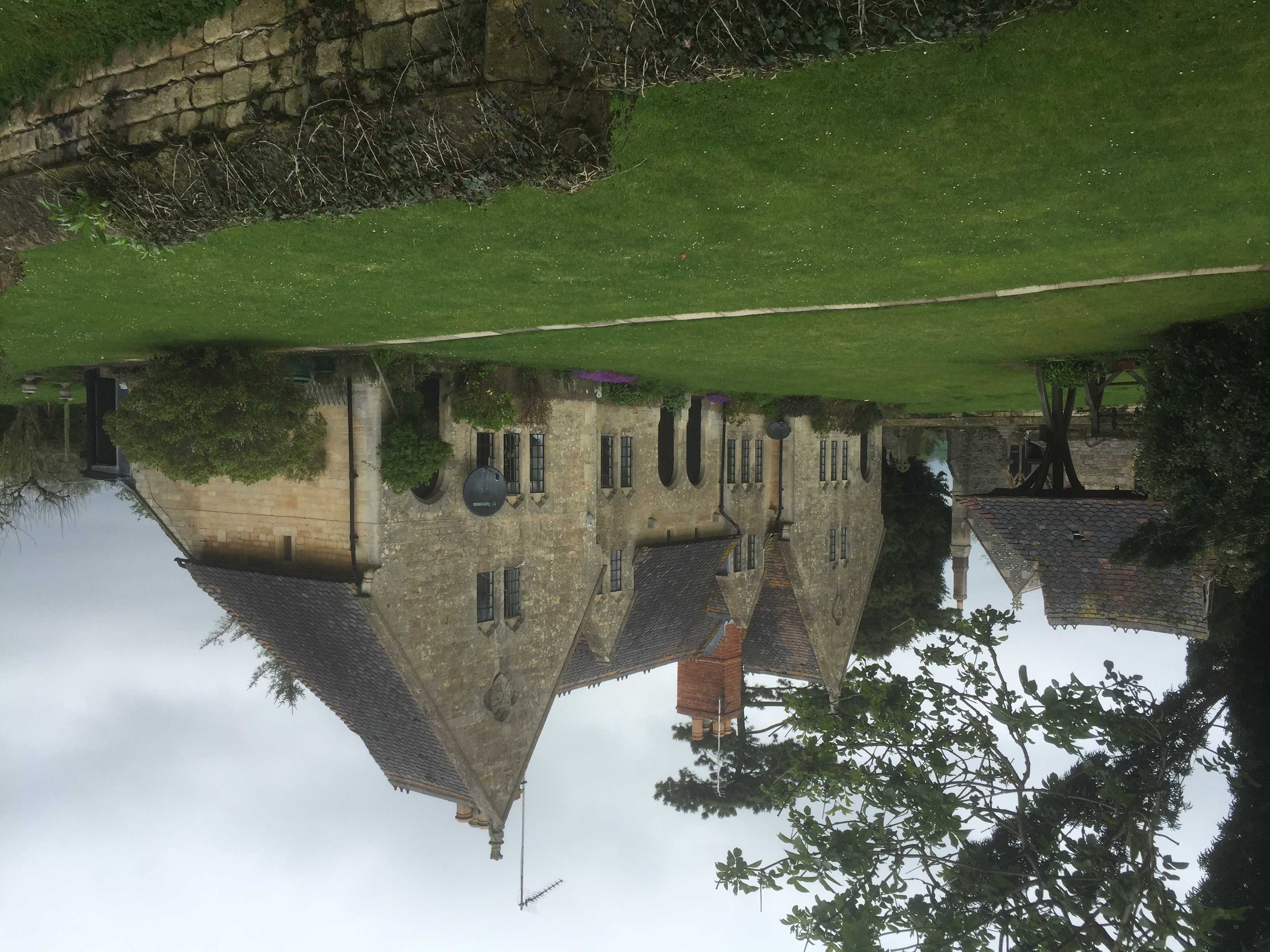
Yorke Almshouses

The Yorke Almshouses, Nos. 14–17 Church Row, Forthampton, Gloucestershire, England, are a range of four almshouses designed by the architect William Burges...

Nearby Amenities

Located within 500m of 51.977092,-2.221163
Hill End
Is In: Gloucestershire, England, UK
Place: hamlet
Source: NPE
Lat/Long: 51.9757781/-2.2206395
Round Hill
Power: pole
Transformer: distribution
Voltage Primary: 11000
Lat/Long: 51.973598/-2.2237645
The data included in this document is from www.openstreetmap.org. The data is made available under ODbL.

Have you been to Chaceley?

Leave your review of Chaceley below (or comments, questions and feedback).