Burrington

Civil Parish in Herefordshire

England

Burrington

Monstay Farm
Monstay Farm Credit: N Chadwick

Burrington is a civil parish located in the county of Herefordshire, England. Situated in the western part of the county, Burrington covers an area of approximately 8 square kilometers and is home to a population of around 300 residents.

The parish is characterized by its picturesque rural landscape, featuring rolling hills, lush green fields, and charming country lanes. It is surrounded by other small villages and hamlets, contributing to its tranquil and secluded atmosphere.

Burrington primarily consists of residential properties, with a mix of traditional cottages and more modern houses. The community is tight-knit and friendly, with a strong sense of community spirit. The parish has a small primary school, providing education for local children.

The local economy in Burrington is mainly agricultural, with farming playing a significant role in the community. The fertile land is used for grazing livestock and cultivating crops, contributing to the region's agricultural heritage.

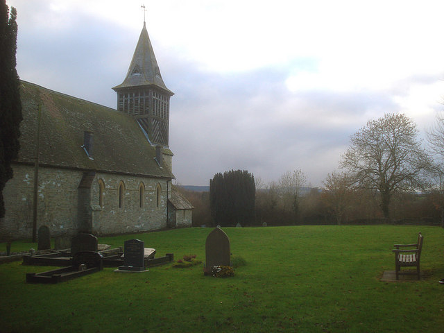
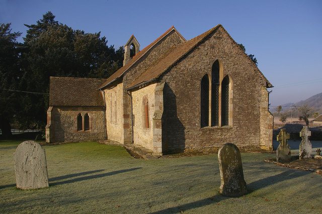
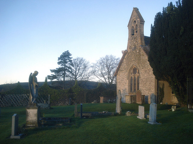
Despite its small size, Burrington offers a range of amenities to its residents. These include a village hall, a church, and a pub, which serves as a social hub for locals and visitors alike.

The parish is well-connected to the surrounding areas, with good road links to nearby towns and cities. It also benefits from its proximity to the stunning Herefordshire countryside, offering residents and visitors ample opportunities for outdoor activities such as walking, hiking, and exploring the natural beauty of the region.

In summary, Burrington is a peaceful and picturesque civil parish in Herefordshire, characterized by its rural charm, strong sense of community, and beautiful countryside.

If you have any feedback on the listing, please let us know in the comments section below.

Burrington Images

Images are sourced within 2km of 52.351897/-2.811144 or Grid Reference SO4472. Thanks to Geograph Open Source API. All images are credited.

Monstay Farm
Monstay Farm
Forestry plantation, Mortimer Forest An ancient hunting forest on the Ludlow Anticlyne. Traditionally an oak forest, coppiced for charcoal it is now a commercial conifer wood. It is managed, but not entirely owned by the Forestry Commission.
The charcoal used to supply the iron smelters at Bringewood Forge.
Since the late 1970s the forest has been opened up to recreational use and is now quite busy, with a dense path network. 
The forest carries a large herd of fallow deer including the long haired variety supposedly unique to Haye Park.
Forestry plantation, Mortimer Forest
An ancient hunting forest on the Ludlow Anticlyne. Traditionally an oak forest, coppiced for charcoal it is now a commercial conifer wood. It is managed, but not entirely owned by the Forestry Commission. The charcoal used to supply the iron smelters at Bringewood Forge. Since the late 1970s the forest has been opened up to recreational use and is now quite busy, with a dense path network. The forest carries a large herd of fallow deer including the long haired variety supposedly unique to Haye Park.
Monstay Farm
Monstay Farm
Track in Mortimer (Bringewood) Forest An ancient hunting forest on the Ludlow Anticlyne. Traditionally an oak forest, coppiced for charcoal it is now a commercial conifer wood. It is managed, but not entirely owned by the Forestry Commission.
The charcoal used to supply the iron smelters at Bringewood Forge.
Since the late 1970s the forest has been opened up to recreational use and is now quite busy, with a dense path network. 
The forest carries a large herd of fallow deer including the long haired variety supposedly unique to Haye Park.
Track in Mortimer (Bringewood) Forest
An ancient hunting forest on the Ludlow Anticlyne. Traditionally an oak forest, coppiced for charcoal it is now a commercial conifer wood. It is managed, but not entirely owned by the Forestry Commission. The charcoal used to supply the iron smelters at Bringewood Forge. Since the late 1970s the forest has been opened up to recreational use and is now quite busy, with a dense path network. The forest carries a large herd of fallow deer including the long haired variety supposedly unique to Haye Park.
Plantation, Bringewood (Mortimer) Forest An ancient hunting forest on the Ludlow Anticlyne. Traditionally an oak forest, coppiced for charcoal it is now a commercial conifer wood. It is managed, but not entirely owned by the Forestry Commission.
The charcoal used to supply the iron smelters at Bringewood Forge.
Since the late 1970s the forest has been opened up to recreational use and is now quite busy, with a dense path network. 
The forest carries a large herd of fallow deer including the long haired variety supposedly unique to Haye Park.
Plantation, Bringewood (Mortimer) Forest
An ancient hunting forest on the Ludlow Anticlyne. Traditionally an oak forest, coppiced for charcoal it is now a commercial conifer wood. It is managed, but not entirely owned by the Forestry Commission. The charcoal used to supply the iron smelters at Bringewood Forge. Since the late 1970s the forest has been opened up to recreational use and is now quite busy, with a dense path network. The forest carries a large herd of fallow deer including the long haired variety supposedly unique to Haye Park.
Track through Bringewood (Mortimer) Forest An ancient hunting forest on the Ludlow Anticlyne. Traditionally an oak forest, coppiced for charcoal it is now a commercial conifer wood. It is managed, but not entirely owned by the Forestry Commission.
The charcoal used to supply the iron smelters at Bringewood Forge.
Since the late 1970s the forest has been opened up to recreational use and is now quite busy, with a dense path network. 
The forest carries a large herd of fallow deer including the long haired variety supposedly unique to Haye Park.
Track through Bringewood (Mortimer) Forest
An ancient hunting forest on the Ludlow Anticlyne. Traditionally an oak forest, coppiced for charcoal it is now a commercial conifer wood. It is managed, but not entirely owned by the Forestry Commission. The charcoal used to supply the iron smelters at Bringewood Forge. Since the late 1970s the forest has been opened up to recreational use and is now quite busy, with a dense path network. The forest carries a large herd of fallow deer including the long haired variety supposedly unique to Haye Park.
Small pond near Monstay Farm
Conifer plantation, Mortimer (Bringewood) Forest The Mortimer Forest is the name given to the remnant of a Saxon Hunting forest on the Shropshire / Herefordshire border near Ludlow (Bringewood Forest). It is owned and managed by the Forestry Commission, who invented the name. The forest has car parks, information boards and trails.  The underlying rocks are Upper Silurian and the forest is the type site for these rocks (the Ludlovian).
Conifer plantation, Mortimer (Bringewood) Forest
The Mortimer Forest is the name given to the remnant of a Saxon Hunting forest on the Shropshire / Herefordshire border near Ludlow (Bringewood Forest). It is owned and managed by the Forestry Commission, who invented the name. The forest has car parks, information boards and trails. The underlying rocks are Upper Silurian and the forest is the type site for these rocks (the Ludlovian).
Track junction near Monstay Farm
Track heading to Burrington
Coppiced tree and fence
Track heading downhill towards Burrington
Coppiced trees on the edge of Bringewood Forest An ancient hunting forest on the Ludlow Anticlyne. Traditionally an oak forest, coppiced for charcoal it is now a commercial conifer wood. It is managed, but not entirely owned by the Forestry Commission.
The charcoal used to supply the iron smelters at Bringewood Forge.
Since the late 1970s the forest has been opened up to recreational use and is now quite busy, with a dense path network. 
The forest carries a large herd of fallow deer including the long haired variety supposedly unique to Haye Park.
Coppiced trees on the edge of Bringewood Forest
An ancient hunting forest on the Ludlow Anticlyne. Traditionally an oak forest, coppiced for charcoal it is now a commercial conifer wood. It is managed, but not entirely owned by the Forestry Commission. The charcoal used to supply the iron smelters at Bringewood Forge. Since the late 1970s the forest has been opened up to recreational use and is now quite busy, with a dense path network. The forest carries a large herd of fallow deer including the long haired variety supposedly unique to Haye Park.
Coppiced fencing near Monstay
Track footpath junction near Monstay The path goes down to Monstay Farm.
Track footpath junction near Monstay
The path goes down to Monstay Farm.
The edge of Bringewood (Mortimer) Forest The Mortimer Forest is the name given to the remnant of a Saxon Hunting forest on the Shropshire / Herefordshire border near Ludlow (Bringewood Forest). It is owned and managed by the Forestry Commission, who invented the name. The forest has car parks, information boards and trails.  The underlying rocks are Upper Silurian and the forest is the type site for these rocks (the Ludlovian).
The edge of Bringewood (Mortimer) Forest
The Mortimer Forest is the name given to the remnant of a Saxon Hunting forest on the Shropshire / Herefordshire border near Ludlow (Bringewood Forest). It is owned and managed by the Forestry Commission, who invented the name. The forest has car parks, information boards and trails. The underlying rocks are Upper Silurian and the forest is the type site for these rocks (the Ludlovian).
Open gate to New House
Bringewood (Mortimer) Forest The Mortimer Forest is the name given to the remnant of a Saxon Hunting forest on the Shropshire / Herefordshire border near Ludlow (Bringewood Forest). It is owned and managed by the Forestry Commission, who invented the name. The forest has car parks, information boards and trails.  The underlying rocks are Upper Silurian and the forest is the type site for these rocks (the Ludlovian).
Bringewood (Mortimer) Forest
The Mortimer Forest is the name given to the remnant of a Saxon Hunting forest on the Shropshire / Herefordshire border near Ludlow (Bringewood Forest). It is owned and managed by the Forestry Commission, who invented the name. The forest has car parks, information boards and trails. The underlying rocks are Upper Silurian and the forest is the type site for these rocks (the Ludlovian).
Show me another place!

Burrington is located at Grid Ref: SO4472 (Lat: 52.351897, Lng: -2.811144)

Unitary Authority: County of Herefordshire

Police Authority: West Mercia

What 3 Words

///enhancement.tram.pink. Near Burrington, Herefordshire

Related Wikis

Burrington, Herefordshire

Burrington is a small village and civil parish in the far north of Herefordshire, England. It is part of the Leintwardine group of parishes and shares...

Pipe Aston

Pipe Aston is a small village and civil parish in the far north of Herefordshire, close to the border with Shropshire. It has a population of about 24...
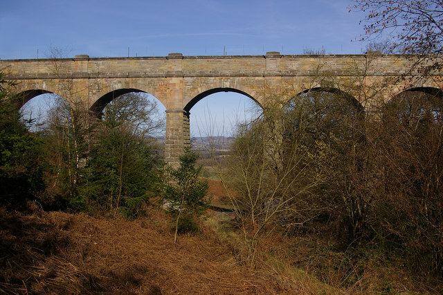
Elan aqueduct

The Elan aqueduct crosses Wales and the Midlands of England, running eastwards from the Elan Valley Reservoirs in Mid Wales to Birmingham's Frankley Reservoir...

Downton Castle

Downton Castle is a grade I listed 18th-century country house in the parish of Downton on the Rock in Herefordshire, England, situated about 5 miles...

Downton, Herefordshire

Downton is a civil parish in Herefordshire, located in the north of the county and containing the village of Downton-on-the-Rock. It is part of the Leintwardine...

Elton, Herefordshire

Elton is a hamlet and civil parish in the far north of Herefordshire. It is situated on the Wigmore to Ludlow road. The village is northeast of Leinthall...

Bringewood Ironworks

Bringewood Ironworks was a charcoal ironworks in north Herefordshire. It was powered by the river Teme, with a blast furnace, a finery forge and latterly...

High Vinnalls

High Vinnalls is a hill in the English county of Herefordshire, though commonly considered a member of the Shropshire Hills. It is located in the parish...

Nearby Amenities

Located within 500m of 52.351897,-2.811144
Grit Bin
Source: survey
Lat/Long: 52.350957/-2.8089997
The data included in this document is from www.openstreetmap.org. The data is made available under ODbL.

Have you been to Burrington?

Leave your review of Burrington below (or comments, questions and feedback).