Bredon

Civil Parish in Worcestershire Wychavon

England

Bredon

Riverside patio at the Fleet Inn Looking east across the river Avon flood plain. Just the place to relax on a sunny afternoon!
<span class="nowrap"><a title="http://www.fleet-inn.co.uk/" rel="nofollow ugc noopener" href="http://www.fleet-inn.co.uk/">Link</a><img style="margin-left:2px;" alt="External link" title="External link - shift click to open in new window" src="https://s1.geograph.org.uk/img/external.png" width="10" height="10"/></span>
<a href="https://www.geograph.org.uk/photo/1567284">SO9036 : Fleet Inn, Twyning</a>
Riverside patio at the Fleet Inn Credit: Trevor Rickard

Bredon is a civil parish located in Worcestershire, England. Situated on the western bank of the River Avon, it is part of the Wychavon district. The parish covers an area of approximately 2.5 square miles and is home to a population of around 1,500 people.

The village of Bredon is known for its picturesque setting, surrounded by rolling countryside and boasting stunning views of Bredon Hill, an iconic landmark in the area. The hill is a popular attraction for hikers and nature enthusiasts, offering a range of walking trails and abundant wildlife.

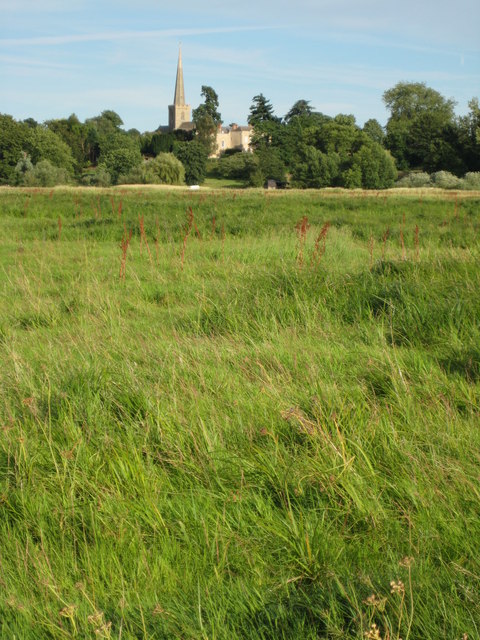
The village itself has a rich history, with evidence of human settlement dating back to the Roman period. It features a number of historic buildings, including the 14th-century St. Giles' Church, which is renowned for its beautiful stained glass windows.

Bredon offers a range of amenities for its residents, including a primary school, a village hall, and a community shop. The village also has several pubs and restaurants, providing a welcoming atmosphere for locals and visitors alike.

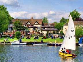
The surrounding area offers plenty of opportunities for outdoor activities, with the nearby River Avon providing opportunities for boating and fishing. Bredon is also well-connected, with good transport links to nearby towns and cities, including Tewkesbury and Worcester.

Overall, Bredon is a charming village with a rich history and stunning natural surroundings, making it an attractive place to live and visit.

If you have any feedback on the listing, please let us know in the comments section below.

Bredon Images

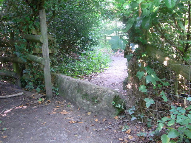
Images are sourced within 2km of 52.025382/-2.113446 or Grid Reference SO9236. Thanks to Geograph Open Source API. All images are credited.

Riverside patio at the Fleet Inn Looking east across the river Avon flood plain. Just the place to relax on a sunny afternoon!
<span class="nowrap"><a title="http://www.fleet-inn.co.uk/" rel="nofollow ugc noopener" href="http://www.fleet-inn.co.uk/">Link</a><img style="margin-left:2px;" alt="External link" title="External link - shift click to open in new window" src="https://s1.geograph.org.uk/img/external.png" width="10" height="10"/></span>
<a href="https://www.geograph.org.uk/photo/1567284">SO9036 : Fleet Inn, Twyning</a>
Riverside patio at the Fleet Inn
Looking east across the river Avon flood plain. Just the place to relax on a sunny afternoon! LinkExternal link SO9036 : Fleet Inn, Twyning
Pond near R.Avon,  Bredon Taken from footpath 512.
Pond near R.Avon, Bredon
Taken from footpath 512.
Footpath over railway bridge, Bredon
Cross-field to B 4080 Footpath over to the main road, Bredon/Westmancote area.
Cross-field to B 4080
Footpath over to the main road, Bredon/Westmancote area.
Old stone on footpath/boundary No barrier to cyclists or horse-riders, Bredon.
Old stone on footpath/boundary
No barrier to cyclists or horse-riders, Bredon.
How old do you feel ? Abandoned stile and sign inside Bredon Tithe Barn, National Trust property.
How old do you feel ?
Abandoned stile and sign inside Bredon Tithe Barn, National Trust property.
M5 Motorway - Worcestershire Border Sign Northbound
Road junction at Bredon's Hardwick
Restored Quarry The unlovely aspect of the water park at Bredon's Hardwick, not enhanced by scruffy signs or the displeasing sight of a caravan park.
Restored Quarry
The unlovely aspect of the water park at Bredon's Hardwick, not enhanced by scruffy signs or the displeasing sight of a caravan park.
Access to Croft Farm water park
Bus stop in Bredon's Hardwick
Roadworks at the M5 bridge The B4080's remarkably oblique bridge is receiving attention.
Roadworks at the M5 bridge
The B4080's remarkably oblique bridge is receiving attention.
B4080 in Bredon
B4080 in Bredon
Old pub in Bredon village
Curve on Moreton Lane (B4080)
B4080 at the junction for Westmancote
Kemerton Lake View of architectural sculpture at Kemerton Lake
Kemerton Lake
View of architectural sculpture at Kemerton Lake
Kemerton Park with redpoll cattle Kemerton Park after the 2007 floods, with redpoll cattle
Kemerton Park with redpoll cattle
Kemerton Park after the 2007 floods, with redpoll cattle
Show me another place!

Bredon is located at Grid Ref: SO9236 (Lat: 52.025382, Lng: -2.113446)

Administrative County: Worcestershire

District: Wychavon

Police Authority: West Mercia

What 3 Words

///bats.preheated.fired. Near Bredon, Worcestershire

Nearby Locations

Bredon Bredon

Related Wikis

Bredon railway station

Bredon railway station was on the Birmingham–Gloucester railway line to the north of Ashchurch for Tewkesbury railway station. The station closed in 1965...

Bredon

Bredon is a village and civil parish in Wychavon district at the southern edge of Worcestershire in England. It lies on the banks of the River Avon on...
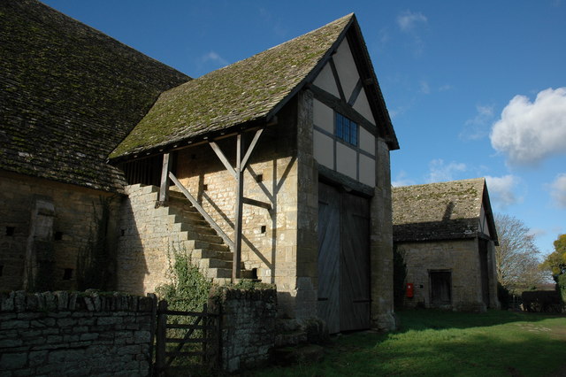
Bredon Barn

Bredon Barn is a large 14th-century threshing barn located at Bredon, Worcestershire, England, standing close to the River Avon.The barn was built for...

Upham Meadow and Summer Leasow

Upham Meadow and Summer Leasow (grid reference SO917375) is a 104.0-hectare (257-acre) biological Site of Special Scientific Interest on the border between...

Kemerton Court

Kemerton Court is the principal manor house of the village of Kemerton, near Tewkesbury in Gloucestershire. The house is built of local Cotswold stone...

Twyning

Twyning is a village and civil parish on the River Avon in the north of Gloucestershire, near Tewkesbury, England. The parish is first mentioned in the...

Northway, Gloucestershire

Northway is a village and civil parish in Gloucestershire, England, 2 miles north-east of Tewkesbury, and is in effect a suburb of that town. The parish...

Kemerton

Kemerton is a village and civil parish in Worcestershire in England. It lies at the extreme south of the county in the local government district of Wychavon...

Nearby Amenities

Located within 500m of 52.025382,-2.113446
Turning Circle
Lat/Long: 52.0275891/-2.1081071
Turning Circle
Lat/Long: 52.0280919/-2.1081147
Barrier: kissing_gate
Lat/Long: 52.0271465/-2.1077807
Barrier: stile
Lat/Long: 52.0235788/-2.1085124
Man Made: mast
Lat/Long: 52.0265913/-2.1080473
Man Made: mast
Lat/Long: 52.0265978/-2.1082779
Material: wood
Power: pole
Lat/Long: 52.0240475/-2.1077645
Material: wood
Power: pole
Lat/Long: 52.0246153/-2.1065253
Location Transition: yes
Power: pole
Lat/Long: 52.0238033/-2.1083224
Material: wood
Power: pole
Lat/Long: 52.0237101/-2.1070737
Material: wood
Power: pole
Lat/Long: 52.0243131/-2.1071849
Power: pole
Lat/Long: 52.0233081/-2.1118211
Location Transition: yes
Power: pole
Lat/Long: 52.0237092/-2.1091361
Power: pole
Lat/Long: 52.0236311/-2.1097775
Power: pole
Lat/Long: 52.0235375/-2.1104451
Power: pole
Lat/Long: 52.0234301/-2.1111225
Power: pole
Lat/Long: 52.0232782/-2.1170073
Power: pole
Lat/Long: 52.0233046/-2.1178066
Power: pole
Lat/Long: 52.0256765/-2.1203075
Power: pole
Lat/Long: 52.0231909/-2.114648
Power: pole
Lat/Long: 52.0246961/-2.1204577
Material: wood
Power: pole
Lat/Long: 52.0234946/-2.1192292
Power: pole
Lat/Long: 52.0231645/-2.1128938
Wych Elm
Power: pole
Transformer: distribution
Voltage Primary: 11000
Lat/Long: 52.0265161/-2.1201525
Power: pole
Lat/Long: 52.0232173/-2.115458
Power: pole
Lat/Long: 52.0231858/-2.1138315
Pipeline: marker
Substance: gas
Lat/Long: 52.0270811/-2.1085142
Generator Method: photovoltaic
Generator Output Electricity: yes
Generator Source: solar
Generator Type: solar_photovoltaic_panel
Location: roof
Power: generator
Lat/Long: 52.0275761/-2.108366
Generator Method: photovoltaic
Generator Output Electricity: yes
Generator Source: solar
Generator Type: solar_photovoltaic_panel
Location: roof
Power: generator
Lat/Long: 52.0274684/-2.108014
Generator Method: photovoltaic
Generator Output Electricity: yes
Generator Source: solar
Generator Type: solar_photovoltaic_panel
Location: roof
Power: generator
Lat/Long: 52.0273285/-2.1079159
Generator Method: photovoltaic
Generator Output Electricity: yes
Generator Source: solar
Generator Type: solar_photovoltaic_panel
Location: roof
Power: generator
Lat/Long: 52.0273194/-2.1078582
Power: pole
Lat/Long: 52.0245806/-2.1072279
Power: pole
Lat/Long: 52.025381/-2.1073821
Carrant Farm Cell Site
Power: pole
Transformer: distribution
Voltage Primary: 11000
Lat/Long: 52.0263164/-2.107584
Turning Circle
Lat/Long: 52.0280287/-2.1082049
Turning Circle
Lat/Long: 52.0275788/-2.1080009
The data included in this document is from www.openstreetmap.org. The data is made available under ODbL.

Have you been to Bredon?

Leave your review of Bredon below (or comments, questions and feedback).