Barston

Civil Parish in Warwickshire Solihull

England

Barston

Hampton in Arden from the air The Parish Church of Saint Mary and Saint Bartholomew can be seen near the centre of the photo. Viewed on approach to Birmingham from a flight from Prague.
Hampton in Arden from the air Credit: Thomas Nugent

Barston is a small civil parish located in the county of Warwickshire in the West Midlands region of England. Situated approximately 10 miles southeast of Birmingham city center, it covers an area of around 2 square miles.

The village of Barston is characterized by its rural charm and picturesque surroundings. It is predominantly residential, with a population of around 500 people. The parish is known for its peaceful and tranquil atmosphere, offering a pleasant escape from the hustle and bustle of city life.

The centerpiece of Barston is the historic St. Swithin's Church, which dates back to the 12th century. This beautiful Grade II* listed building adds to the village's charm and serves as a place of worship for the local community.

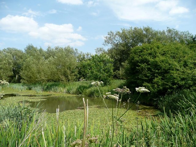
Barston is surrounded by stunning countryside, with fields and woodlands providing opportunities for outdoor activities such as hiking and cycling. The village is also home to a number of small businesses, including a pub and a few shops, offering essential services and local goods.

Despite its small size, Barston benefits from good transport links, with easy access to major roads such as the M42 and A452. This allows residents to easily commute to nearby towns and cities for work or leisure.

In summary, Barston is a delightful rural parish in Warwickshire, offering a peaceful and idyllic lifestyle amidst beautiful countryside. With its historic church, small businesses, and convenient location, it is a beloved place for both residents and visitors alike.

If you have any feedback on the listing, please let us know in the comments section below.

Barston Images

Images are sourced within 2km of 52.404594/-1.708157 or Grid Reference SP1978. Thanks to Geograph Open Source API. All images are credited.

Hampton in Arden from the air The Parish Church of Saint Mary and Saint Bartholomew can be seen near the centre of the photo. Viewed on approach to Birmingham from a flight from Prague.
Hampton in Arden from the air
The Parish Church of Saint Mary and Saint Bartholomew can be seen near the centre of the photo. Viewed on approach to Birmingham from a flight from Prague.
Hampton in Arden from the air The railway line which bisects the village can be seen on the right. Viewed on approach to Birmingham from a flight from Prague.
Hampton in Arden from the air
The railway line which bisects the village can be seen on the right. Viewed on approach to Birmingham from a flight from Prague.
Pool in Marsh Lane Nature Reserve
Barston Sewage Treatment Works On the road to Ryton End.
Barston Sewage Treatment Works
On the road to Ryton End.
Piercil End-North Lodge The end of the road.
Piercil End-North Lodge
The end of the road.
Barston Power Lines Near Northfield Farm.
Barston Power Lines
Near Northfield Farm.
West Midlands Golf Club from the air Seen on approach to Birmingham Airport from a flight from Prague.
West Midlands Golf Club from the air
Seen on approach to Birmingham Airport from a flight from Prague.
Blythe House Farm from the air Seen on approach to Birmingham Airport from a flight from Prague.
Blythe House Farm from the air
Seen on approach to Birmingham Airport from a flight from Prague.
Northfields Farm from the air Hampton in Arden can be seen in the background, as can some of the lakes at Marsh Lane nature reserve. Viewed on approach to Birmingham from a flight from Prague.
Northfields Farm from the air
Hampton in Arden can be seen in the background, as can some of the lakes at Marsh Lane nature reserve. Viewed on approach to Birmingham from a flight from Prague.
West Midlands Golf Club from the air Viewed on approach to Birmingham from a flight from Prague.
West Midlands Golf Club from the air
Viewed on approach to Birmingham from a flight from Prague.
West Midlands Golf Club from the air The A452 dual carriageway is in the background. Viewed on approach to Birmingham from a flight from Prague.
West Midlands Golf Club from the air
The A452 dual carriageway is in the background. Viewed on approach to Birmingham from a flight from Prague.
Red Barnes at Walsal End A fine house with a 17th century core, albeit some later alterations. It was Grade II listed <span class="nowrap"><a title="https://britishlistedbuildings.co.uk/101045829-red-barns-barston#.YveclnbMLIU" rel="nofollow ugc noopener" href="https://britishlistedbuildings.co.uk/101045829-red-barns-barston#.YveclnbMLIU">Link</a><img style="margin-left:2px;" alt="External link" title="External link - shift click to open in new window" src="https://s1.geograph.org.uk/img/external.png" width="10" height="10"/></span> & <span class="nowrap"><a title="https://historicengland.org.uk/listing/the-list/list-entry/1045829" rel="nofollow ugc noopener" href="https://historicengland.org.uk/listing/the-list/list-entry/1045829">Link</a><img style="margin-left:2px;" alt="External link" title="External link - shift click to open in new window" src="https://s1.geograph.org.uk/img/external.png" width="10" height="10"/></span> in 1952.
Red Barnes at Walsal End
A fine house with a 17th century core, albeit some later alterations. It was Grade II listed LinkExternal link & LinkExternal link in 1952.
Tythe Barn at Walsal End This appears from the maps on their site, to be the property described by Historic England as 'Barn 50 yards SE of Walsal End Farmhouse', and it certainly matches the description in terms of having a timber frame, red brick nogging and an old tile roof. Unusually however, none of the window apertures or dormers are described in its 1952 Grade II listing details <span class="nowrap"><a title="https://britishlistedbuildings.co.uk/101075968-barn-50-yards-south-east-of-walsal-end-farmhouse-barston#.Yved0nbMLIU" rel="nofollow ugc noopener" href="https://britishlistedbuildings.co.uk/101075968-barn-50-yards-south-east-of-walsal-end-farmhouse-barston#.Yved0nbMLIU">Link</a><img style="margin-left:2px;" alt="External link" title="External link - shift click to open in new window" src="https://s1.geograph.org.uk/img/external.png" width="10" height="10"/></span> & <span class="nowrap"><a title="https://historicengland.org.uk/listing/the-list/list-entry/1075968?section=official-list-entry" rel="nofollow ugc noopener" href="https://historicengland.org.uk/listing/the-list/list-entry/1075968?section=official-list-entry">Link</a><img style="margin-left:2px;" alt="External link" title="External link - shift click to open in new window" src="https://s1.geograph.org.uk/img/external.png" width="10" height="10"/></span>
Tythe Barn at Walsal End
This appears from the maps on their site, to be the property described by Historic England as 'Barn 50 yards SE of Walsal End Farmhouse', and it certainly matches the description in terms of having a timber frame, red brick nogging and an old tile roof. Unusually however, none of the window apertures or dormers are described in its 1952 Grade II listing details LinkExternal link & LinkExternal link
Barn at Walsal End Farm The same property as <a href="https://www.geograph.org.uk/photo/3267314">SP2079 : Converted Barn at Walsal End</a>, which is a 17th century farm barn converted to a house. It was Grade II listed <span class="nowrap"><a title="https://britishlistedbuildings.co.uk/101370029-barn-at-walsal-end-farm-barston#.Yveg_nbMLIU" rel="nofollow ugc noopener" href="https://britishlistedbuildings.co.uk/101370029-barn-at-walsal-end-farm-barston#.Yveg_nbMLIU">Link</a><img style="margin-left:2px;" alt="External link" title="External link - shift click to open in new window" src="https://s1.geograph.org.uk/img/external.png" width="10" height="10"/></span> & <span class="nowrap"><a title="https://historicengland.org.uk/listing/the-list/list-entry/1370029" rel="nofollow ugc noopener" href="https://historicengland.org.uk/listing/the-list/list-entry/1370029">Link</a><img style="margin-left:2px;" alt="External link" title="External link - shift click to open in new window" src="https://s1.geograph.org.uk/img/external.png" width="10" height="10"/></span> in 1952.
Barn at Walsal End Farm
The same property as SP2079 : Converted Barn at Walsal End, which is a 17th century farm barn converted to a house. It was Grade II listed LinkExternal link & LinkExternal link in 1952.
Footbridge over a brook south of Hampton in Arden In the gently-flowing water were the distinctive oval leaves of a Pondweed, Potamogeton species. Behind the camera, to the south, is an arable field, newly ploughed and harrowed. The overgrown field ahead appears to be an abandoned plant nursery.
Footbridge over a brook south of Hampton in Arden
In the gently-flowing water were the distinctive oval leaves of a Pondweed, Potamogeton species. Behind the camera, to the south, is an arable field, newly ploughed and harrowed. The overgrown field ahead appears to be an abandoned plant nursery.
Looking southeast beneath trees from the edge of Hampton in Arden Behind the camera are suburban gardens and the end of Belle Vue Terrace.
Looking southeast beneath trees from the edge of Hampton in Arden
Behind the camera are suburban gardens and the end of Belle Vue Terrace.
Properties on Bellemere Road, Hampton in Arden Bellemere Drive appears as a straggle of houses at the southeast corner of Hampton in Arden. The furthest south, on the right, is a substantial property called Hook End.
Properties on Bellemere Road, Hampton in Arden
Bellemere Drive appears as a straggle of houses at the southeast corner of Hampton in Arden. The furthest south, on the right, is a substantial property called Hook End.
Running south to Barston from Hampton in Arden From what I gathered, this cheerful, strapping young man was training by running across the fields between Hampton in Arden and Barston – about 2·5km – and back, possibly repeatedly.
Running south to Barston from Hampton in Arden
From what I gathered, this cheerful, strapping young man was training by running across the fields between Hampton in Arden and Barston – about 2·5km – and back, possibly repeatedly.
Show me another place!

Barston is located at Grid Ref: SP1978 (Lat: 52.404594, Lng: -1.708157)

Administrative County: West Midlands

District: Solihull

Police Authority: West Midlands

What 3 Words

///brownish.mice.muted. Near Barston, West Midlands

Nearby Locations

Barston

Related Wikis

Meriden (UK Parliament constituency)

Meriden is a constituency represented in the House of Commons of the UK Parliament since 2019 by Saqib Bhatti, a Conservative. It is named after the village...

Barston

Barston is a village and civil parish in Metropolitan Borough of Solihull in the West Midlands of England. It is approximately 4.5 miles (7 km) east of...

Grimshaw Hall

Built in c.1560, Grimshaw Hall (grid reference SP184774) is a half-timbered Tudor manor house located in the village of Knowle, approximately 15 miles...

Hampton in Arden packhorse bridge

Hampton in Arden packhorse bridge crosses the River Blythe near Hampton in Arden in the West Midlands (historically Warwickshire) of England, between Birmingham...
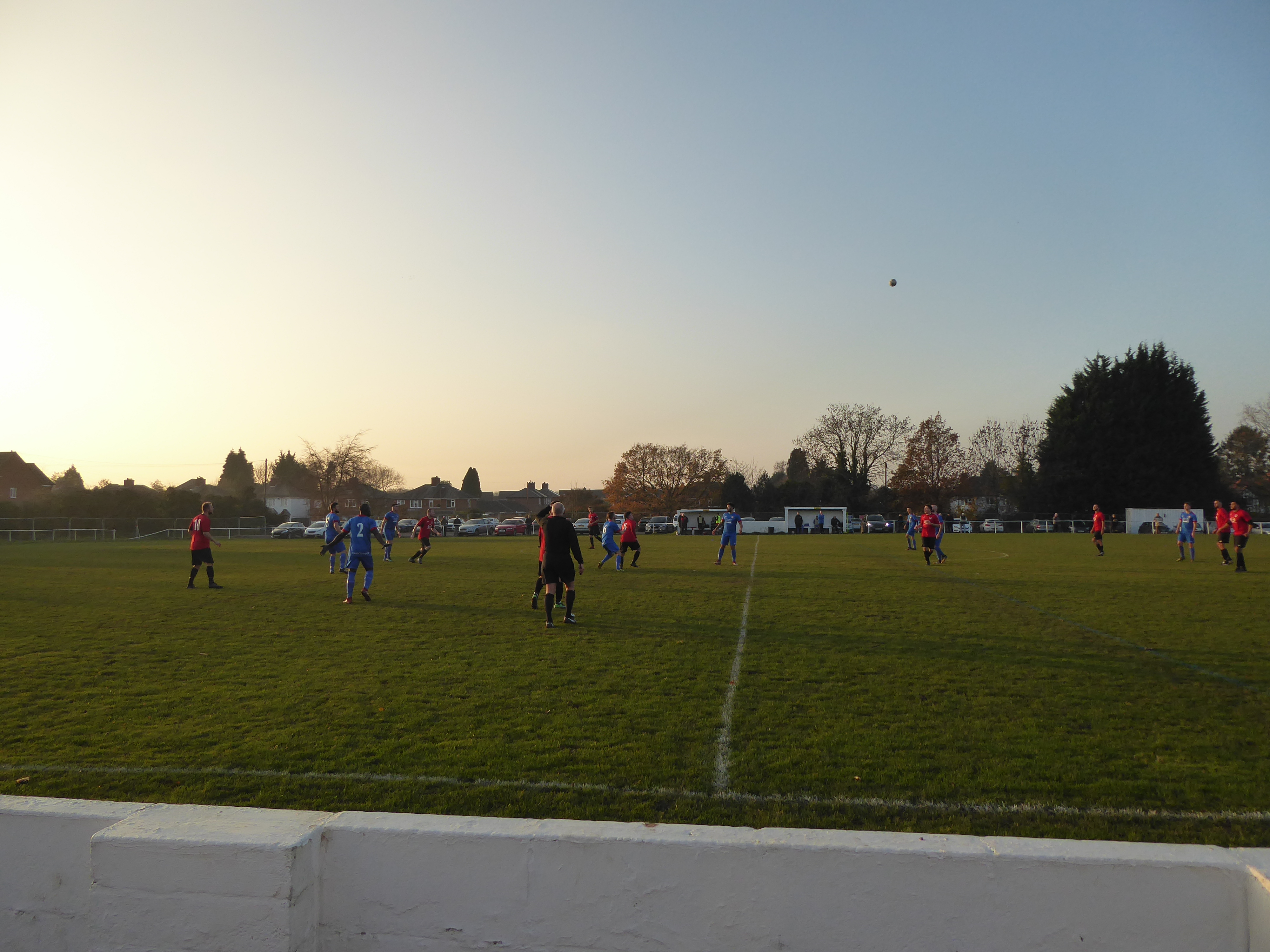
Knowle F.C.

Knowle Football Club is a football club based in Knowle Solihull, in the West Midlands, England. They are currently members of the Midland League Division...

Catherine-de-Barnes Isolation Hospital

Catherine-de-Barnes Isolation Hospital was a specialist isolation hospital for infection control in Catherine-de-Barnes, a village within the Metropolitan...

Peel's Restaurant

Peel's Restaurant is situated in Hampton Manor, Hampton-in-Arden. It currently holds one Michelin star and four AA Rosettes. Hampton Manor is a Grade II...

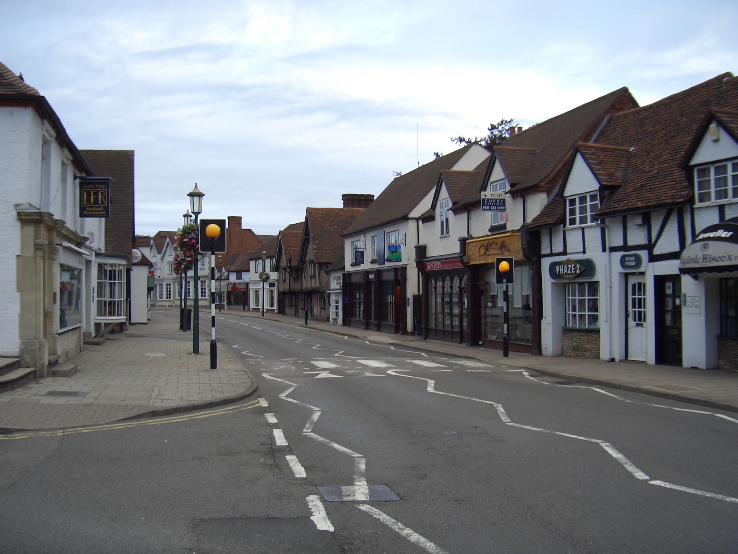
Knowle, West Midlands

Knowle is a large village situated 3 miles (5 km) east-southeast of the town of Solihull, West Midlands, England. Knowle lies within the Arden area of...

Nearby Amenities

Located within 500m of 52.404594,-1.708157
Generator Method: photovoltaic
Generator Output Electricity: yes
Generator Source: solar
Generator Type: solar_photovoltaic_panel
Location: roof
Power: generator
Lat/Long: 52.4012181/-1.7056281
Generator Method: photovoltaic
Generator Output Electricity: yes
Generator Source: solar
Generator Type: solar_photovoltaic_panel
Location: roof
Power: generator
Lat/Long: 52.4029278/-1.7045009
Generator Method: photovoltaic
Generator Output Electricity: yes
Generator Source: solar
Generator Type: solar_photovoltaic_panel
Location: roof
Power: generator
Lat/Long: 52.4063805/-1.7102248
Power: pole
Source: bing
Lat/Long: 52.4062251/-1.7055979
Power: pole
Source: bing
Lat/Long: 52.4056786/-1.7043024
Power: pole
Source: bing
Lat/Long: 52.4049488/-1.7025965
Power: pole
Source: bing
Lat/Long: 52.4066963/-1.706652
Power: pole
Source: bing
Lat/Long: 52.4070907/-1.7077115
Power: pole
Source: bing
Lat/Long: 52.4079677/-1.709699
Power: pole
Source: bing
Lat/Long: 52.4084406/-1.7108765
Power: pole
Ref: 721123
Source: wpd_open_data
Transformer: distribution
Lat/Long: 52.4058917/-1.708948
Power: pole
Source: bing
Lat/Long: 52.4064983/-1.7083606
Power: pole
Source: bing
Lat/Long: 52.4042222/-1.7020923
Power: pole
Ref: 720223
Transformer: distribution
Lat/Long: 52.4028771/-1.7029989
Power: pole
Source: bing
Lat/Long: 52.4035251/-1.7025751
Power: pole
Source: bing
Lat/Long: 52.4046264/-1.7018697
Gatehouse
Addr City: Solihull
Addr Housename: The Gate House
Addr Postcode: B92 0JN
Addr Street: Barston Lane
Fhrs Id: 524109
Tourism: guest_house
Lat/Long: 52.4031017/-1.7038652
The data included in this document is from www.openstreetmap.org. The data is made available under ODbL.

Have you been to Barston?

Leave your review of Barston below (or comments, questions and feedback).