Aston Ingham

Civil Parish in Herefordshire

England

Aston Ingham

Farmhouse, Clifford's Mesne Like many of the older properties around here, this has a stone basement and brick upper stories.
Farmhouse, Clifford's Mesne Credit: Jonathan Thacker

Aston Ingham is a civil parish located in the county of Herefordshire, England. Situated in the eastern part of the county, it is surrounded by the beautiful countryside and rolling hills that are characteristic of the region. The village itself is small and quaint, with a population of around 200 residents.

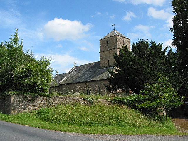
Aston Ingham has a rich history, with evidence of settlements dating back to the Iron Age. The parish features several historic buildings, including the Church of St. John the Baptist, which dates back to the 12th century. The church is a prominent feature in the village and is known for its stunning architecture and beautiful stained glass windows.

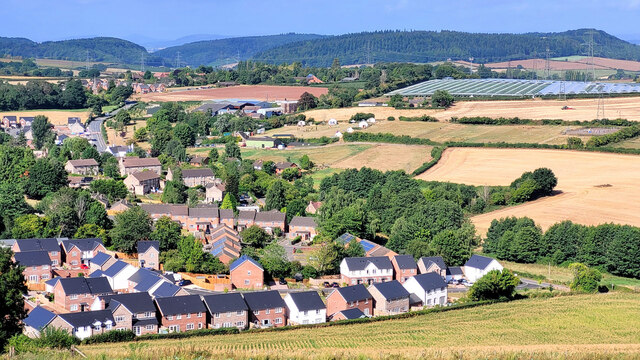
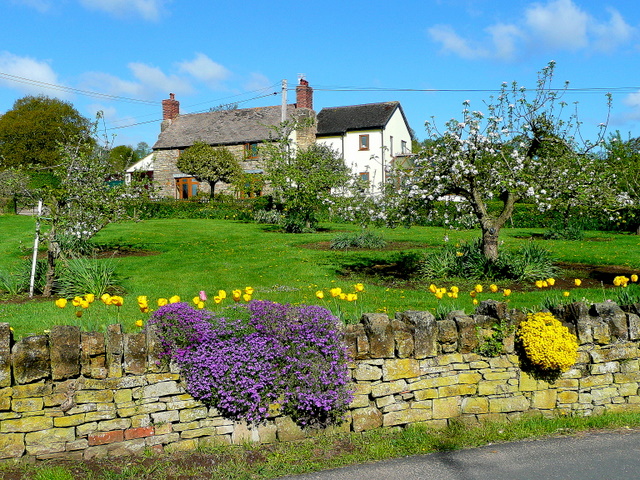
The village is primarily residential, with a mix of traditional cottages and modern houses. The community is close-knit and friendly, with various social events and activities organized throughout the year. Aston Ingham also benefits from a local pub, providing a gathering place for residents and visitors alike.

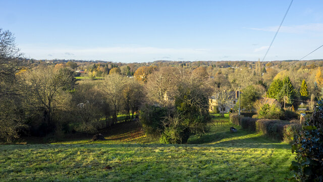
Surrounding the village are vast farmlands and orchards, which contribute to the rural charm of the area. The landscape is dotted with picturesque farms and fields, offering breathtaking views of the Herefordshire countryside.

Overall, Aston Ingham is a peaceful and idyllic village, perfect for those seeking a tranquil rural retreat. Its rich history, stunning natural surroundings, and welcoming community make it a desirable place to live or visit in Herefordshire.

If you have any feedback on the listing, please let us know in the comments section below.

Aston Ingham Images

Images are sourced within 2km of 51.904666/-2.46563 or Grid Reference SO6823. Thanks to Geograph Open Source API. All images are credited.

Farmhouse, Clifford's Mesne Like many of the older properties around here, this has a stone basement and brick upper stories.
Farmhouse, Clifford's Mesne
Like many of the older properties around here, this has a stone basement and brick upper stories.
St. Peter's church, Clifford's Mesne
Barrel Lane Early autumn as evidenced by the Colchicums (Autumn Crocus) to the left.
Barrel Lane
Early autumn as evidenced by the Colchicums (Autumn Crocus) to the left.
Autumn Crocus, Colchicum Looking splendid in the September sunshine by Barrel Lane.
See <a href="https://www.geograph.org.uk/photo/6966541">SO6821 : Barrel Lane</a> for context.
Autumn Crocus, Colchicum
Looking splendid in the September sunshine by Barrel Lane. See SO6821 : Barrel Lane for context.
Yartleton Lane Entering some mature woodland on the south side of May Hill.
Yartleton Lane
Entering some mature woodland on the south side of May Hill.
Herefordshire meets Gloucestershire Woodland and small slivers of pasture land.
Herefordshire meets Gloucestershire
Woodland and small slivers of pasture land.
Aston Mills and Warren Farm With Warren Lane meandering off into the middle distance.
Aston Mills and Warren Farm
With Warren Lane meandering off into the middle distance.
View to Chase Hill Looking west across some fine rolling Herefordshire countryside in early December.
View to Chase Hill
Looking west across some fine rolling Herefordshire countryside in early December.
Barrel Lane Looking north from the entrance to Barrel Farm.
Barrel Lane
Looking north from the entrance to Barrel Farm.
Track to Barrel Farm From Barrel Lane.
Track to Barrel Farm
From Barrel Lane.
View from Crews Hill, January 2022 Late afternoon shot with the west-facing pasture in the foreground still bathed in the soft light of approaching sunset.
Distant hill, left, is Chase Hill above Ross-on-Wye.
In the far distance is Hay Bluff.
View from Crews Hill, January 2022
Late afternoon shot with the west-facing pasture in the foreground still bathed in the soft light of approaching sunset. Distant hill, left, is Chase Hill above Ross-on-Wye. In the far distance is Hay Bluff.
Lea This Herefordshire village is expanding rapidly with at least three separate housing developments taking place simultaneously.
Lea
This Herefordshire village is expanding rapidly with at least three separate housing developments taking place simultaneously.
Cottages near Clifford's Mesne The Geopark Way follows this road past these cottages.
Cottages near Clifford's Mesne
The Geopark Way follows this road past these cottages.
May Hill in late summer This spot on the Linton ridge affords a great view of the distinctive dome of May Hill above the harvested fields of this corner of Herefordshire.
May Hill in late summer
This spot on the Linton ridge affords a great view of the distinctive dome of May Hill above the harvested fields of this corner of Herefordshire.
View across Knightshill The village of Lea with its position on the A40 has attracted the attention of housing developers in recent years.
View across Knightshill
The village of Lea with its position on the A40 has attracted the attention of housing developers in recent years.
Aston Mill The Mill has long since closed but the gardens attract many visitors particularly in spring-time.
Aston Mill
The Mill has long since closed but the gardens attract many visitors particularly in spring-time.
Grazing Ponies on May Hill
Fog Filled Woodland below May Hill
Show me another place!

Aston Ingham is located at Grid Ref: SO6823 (Lat: 51.904666, Lng: -2.46563)

Unitary Authority: County of Herefordshire

Police Authority: West Mercia

What 3 Words

///zipped.surcharge.bristle. Near Lea, Herefordshire

Nearby Locations

Aston Ingham Aston Ingham

Related Wikis

Luxley

Luxley is a village in the southwest Midlands of England, on the border between Gloucestershire and Herefordshire near May Hill. Luxley is 12 km (7.5 mi...

Beavan's Hill

Beavan's Hill is a village in south east Herefordshire, England. The village is situated on the edge of Withymoor Wood, an area of ancient woodland, and...

Aston Ingham

Aston Ingham is a village in south-eastern Herefordshire, England, near Newent and about 7 miles (11 km) east of Ross-on-Wye. The population of the village...

May Hill

May Hill is a prominent English hill between Gloucester and Ross-on-Wye. Its summit, on the western edge of Gloucestershire and its northern slopes in...

Burton Court, Linton

Burton Court is a grade II listed, large country house near Linton, Penyard, Herefordshire, England.The house is of brick-faced stone, with five bays....

Cliffords Mesne

Cliffords Mesne is an English village in Gloucestershire, two miles (3.2 km) south-west of the town of Newent. It became the home of the autobiographical...

Gorsley and Kilcot

Gorsley and Kilcot is a civil parish forming part of the district of the Forest of Dean in the English county of Gloucestershire. The single parish of...

Boulsdon

Boulsdon is a village in Gloucestershire, England. It is the location of the International Centre for Birds of Prey.A low mound in the village may have...

Nearby Amenities

Located within 500m of 51.904666,-2.46563
Power: tower
Source: Bing
Lat/Long: 51.9011495/-2.4625581
Location Transition: yes
Power: pole
Lat/Long: 51.9056152/-2.4723195
Woodfield Farm
Location Transition: yes
Power: pole
Transformer: distribution
Voltage Primary: 11000
Lat/Long: 51.9057773/-2.4713398
Location Transition: yes
Power: pole
Lat/Long: 51.9058659/-2.4708154
Location Transition: yes
Power: pole
Lat/Long: 51.9059821/-2.4700892
Location Transition: yes
Power: pole
Lat/Long: 51.9060864/-2.4694388
Location Transition: yes
Power: pole
Lat/Long: 51.9062502/-2.4684081
Power: pole
Lat/Long: 51.9015053/-2.4682277
Power: pole
Lat/Long: 51.9007556/-2.465972
Power: pole
Lat/Long: 51.9014093/-2.4673587
Lower Coldridge Farm
Power: pole
Transformer: distribution
Voltage Primary: 11000
Lat/Long: 51.9018272/-2.4710441
Power: pole
Lat/Long: 51.9016948/-2.4698988
Power: pole
Lat/Long: 51.9015921/-2.469011
Power: pole
Lat/Long: 51.9012521/-2.4659693
Blakemoor Farm
Power: pole
Transformer: distribution
Voltage Primary: 11000
Lat/Long: 51.9018305/-2.4659693
Power: pole
Lat/Long: 51.9022235/-2.4659653
Power: pole
Lat/Long: 51.9026306/-2.4659666
Power: pole
Lat/Long: 51.9030079/-2.4659693
Stank Cottage
Location Transition: yes
Power: pole
Transformer: distribution
Voltage Primary: 11000
Lat/Long: 51.9042342/-2.4609844
Location Transition: yes
Power: pole
Lat/Long: 51.9041519/-2.4617274
Location Transition: yes
Power: pole
Lat/Long: 51.9040646/-2.4625535
Location Transition: yes
Power: pole
Lat/Long: 51.9039761/-2.4633354
Location Transition: yes
Power: pole
Lat/Long: 51.9038917/-2.4641655
Location Transition: yes
Power: pole
Lat/Long: 51.9038056/-2.464989
Location Transition: yes
Power: pole
Lat/Long: 51.9037287/-2.4657226
Power: pole
Lat/Long: 51.9036848/-2.4661611
Power: pole
Lat/Long: 51.904432/-2.4663663
Power: pole
Lat/Long: 51.9051146/-2.4665675
Power: pole
Lat/Long: 51.9059164/-2.4667981
Location Transition: yes
Power: pole
Lat/Long: 51.9064873/-2.4669671
Location Transition: yes
Power: pole
Lat/Long: 51.9066014/-2.4661879
Chicory Crops Ltd
Location Transition: yes
Power: pole
Transformer: distribution
Voltage Primary: 11000
Lat/Long: 51.9069978/-2.4653638
Location Transition: yes
Power: pole
Lat/Long: 51.9075496/-2.4641924
Location Transition: yes
Power: pole
Lat/Long: 51.9081259/-2.4629994
The data included in this document is from www.openstreetmap.org. The data is made available under ODbL.

Have you been to Aston Ingham?

Leave your review of Aston Ingham below (or comments, questions and feedback).