Bridestowe

Settlement in Devon West Devon

England

Bridestowe

Bridge over A30 at Ebsworthy Moor  On the left is the road marking for the access from the bridge for emergency vehicles; there is a long stretch of the A30 without junctions, so provision for emergency vehicles is desirable
Bridge over A30 at Ebsworthy Moor Credit: David Smith

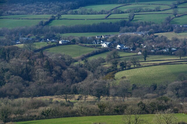
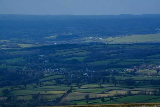
Bridestowe is a picturesque village located in the county of Devon, England. Situated on the northwestern edge of Dartmoor National Park, it offers breathtaking views of the surrounding countryside and is known for its idyllic charm. With a population of around 600 residents, Bridestowe maintains a close-knit community atmosphere.

The village is rich in history, dating back to the Domesday Book in 1086, where it was recorded as "Bristetone." The name is believed to derive from the Old English word "brycg," meaning bridge, and "stow," meaning a place. This suggests the presence of a significant bridge or crossing in the village's early days.

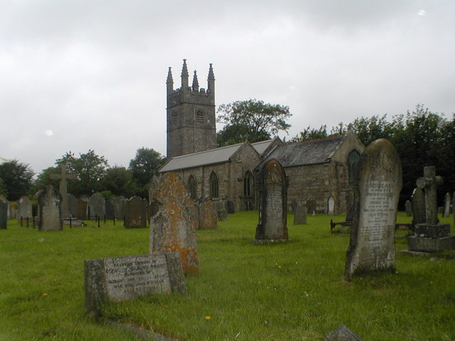
The centerpiece of Bridestowe is the beautiful Church of St. Bridget, a Grade I listed building that dates back to the 13th century. Its striking architecture and stained glass windows attract visitors and locals alike. The village also boasts a primary school, a pub, a village hall, and a small shop, providing essential amenities for residents.

Surrounded by rolling hills and meandering rivers, Bridestowe offers numerous opportunities for outdoor activities. The nearby Dartmoor National Park is a haven for hikers, cyclists, and nature enthusiasts, with its vast moorland, ancient stone tors, and diverse wildlife.

Bridestowe is well-connected to neighboring towns and cities through a network of roads, making it easily accessible. Its proximity to Dartmoor and its natural beauty make it a popular destination for tourists seeking a peaceful retreat in the heart of the Devonshire countryside.

If you have any feedback on the listing, please let us know in the comments section below.

Bridestowe Images

Images are sourced within 2km of 50.685178/-4.104756 or Grid Reference SX5189. Thanks to Geograph Open Source API. All images are credited.

Bridge over A30 at Ebsworthy Moor  On the left is the road marking for the access from the bridge for emergency vehicles; there is a long stretch of the A30 without junctions, so provision for emergency vehicles is desirable
Bridge over A30 at Ebsworthy Moor
On the left is the road marking for the access from the bridge for emergency vehicles; there is a long stretch of the A30 without junctions, so provision for emergency vehicles is desirable
A30 unnamed lane crosses from Rivermead
The A30 westbound near Ebsworthy Town
West Devon : The A30 The A30 heading through the West Devon district and alongside some traffic cones.
West Devon : The A30
The A30 heading through the West Devon district and alongside some traffic cones.
The A30 Near Ebsworthy Town.
The A30
Near Ebsworthy Town.
West Devon : The A30 Looking down towards the A30 road with one carriageway having been shut due to an accident.
West Devon : The A30
Looking down towards the A30 road with one carriageway having been shut due to an accident.
West Devon : The A30 Looking down towards the A30 road with one carriageway having been shut due to an accident.
West Devon : The A30
Looking down towards the A30 road with one carriageway having been shut due to an accident.
Badger's Well Cottages on the old A30 A row of cottages west of Bridestowe
Badger's Well Cottages on the old A30
A row of cottages west of Bridestowe
Dartmoor : Countryside Scenery Looking across the countryside.
Dartmoor : Countryside Scenery
Looking across the countryside.
Dartmoor : Countryside Scenery Looking across the countryside.
Dartmoor : Countryside Scenery
Looking across the countryside.
Dartmoor : Countryside Scenery Looking out across the countryside.
Dartmoor : Countryside Scenery
Looking out across the countryside.
Dartmoor : Countryside Scenery Looking out across the countryside.
Dartmoor : Countryside Scenery
Looking out across the countryside.
Dartmoor : Bridestowe Scenery Looking towards the village of Bridestowe.
Dartmoor : Bridestowe Scenery
Looking towards the village of Bridestowe.
Lake : The A386 Looking along the A386.
Lake : The A386
Looking along the A386.
Lake : The A386 Looking along the A386.
Lake : The A386
Looking along the A386.
Lake : The A386 Entering the hamlet of Lake.
Lake : The A386
Entering the hamlet of Lake.
Lake : The A386 The A386 enters the hamlet of Lake.
Lake : The A386
The A386 enters the hamlet of Lake.
Sourton : The A386 Looking along the A386.
Sourton : The A386
Looking along the A386.
Show me another place!

Bridestowe is located at Grid Ref: SX5189 (Lat: 50.685178, Lng: -4.104756)

Administrative County: Devon

District: West Devon

Police Authority: Devon and Cornwall

What 3 Words

///spends.stuffing.assurance. Near Okehampton, Devon

Nearby Locations

Bridestowe

Related Wikis

Bridestowe

Bridestowe () is a civil parish and village in the district of West Devon, Devon, England. The parish is surrounded clockwise from the north by the parishes...

St Bridget's Church, Bridestowe

St Bridget's Church in Bridestowe, Devon, is a parish church in the Church of England and one of the central buildings in the rural area on the northwestern...

Great Bidlake Manor

Great Bidlake Manor is a Grade II* listed manor house in the parish of Bridestowe on the north western edge of Dartmoor in the county of Devon, England...

Sourton

Sourton is a small village and civil parish in West Devon, England. It lies about 4 miles (6.4 km) south-west of Okehampton. It is at the north-western...

Nearby Amenities

Located within 500m of 50.685178,-4.104756
Bridestowe
Place: village
Wikidata: Q2078817
Wikipedia: en:Bridestowe
Lat/Long: 50.6852365/-4.1047723
Post Office
Riverside Stores & Post Office
Building: yes
Phone: +44 1837 861321
Lat/Long: 50.6843685/-4.1057745
Post Box
Brand: Royal Mail
Brand Wikidata: Q638098
Brand Wikipedia: en:Royal Mail
Collection Times: Mo-Fr 16:45; Sa 11:00; Su off
Drive Through: no
Operator: Royal Mail
Operator Wikidata: Q638098
Post Box Design: type_n
Post Box Mounting: pier
Post Box Type: lamp
Ref: EX20 98
Royal Cypher: EIIR
Royal Cypher Wikidata: Q33102113
Source: survey;streetlevel imagery;aerial imagery
Lat/Long: 50.6843579/-4.1056753
Bus Stop
Bench: yes
Bus: yes
Public Transport: platform
Shelter: yes
Lat/Long: 50.684032/-4.1056434
Telephone
Booth: K6
Covered: booth
Lat/Long: 50.6840588/-4.1056448
Bus Stop
Bus: yes
Public Transport: platform
Lat/Long: 50.6850657/-4.1047782
Royal Oak B&B
Addr City: Bridestowe
Addr Housenumber: 24
Addr Street: Fore Street
Building: yes
Smoking: outside
Tourism: guest_house
Lat/Long: 50.6854045/-4.1045704
Give Way
Direction: forward
Lat/Long: 50.6835973/-4.1065524
Townhall
Bridestowe Village Hall
Lat/Long: 50.6880226/-4.1018278
Pub
The White Hart
Addr City: Okehampton
Addr Postcode: EX20 4EL
Addr Street: Fore Street
Building: yes
Fhrs Id: 1424738
Outdoor Seating: yes
Phone: +44 1837 861318
Smoking: outside
Source Addr: FHRS Open Data
Website: https://whitehartinnbridestowe.com/
Wikidata: Q80476991
Lat/Long: 50.6843449/-4.1053615
Give Way
Lat/Long: 50.6852225/-4.1047095
Place Of Worship
Bridestowe Methodist Church
Addr City: Okehampton
Addr Postcode: EX20 4EJ
Addr Street: Station Road
Denomination: methodist
Fhrs Id: 813862
Religion: christian
Source Addr: FHRS Open Data
Lat/Long: 50.6838303/-4.1055917
Waste Basket
Waste: trash
Lat/Long: 50.684064/-4.1056197
Waste Basket
Waste: trash
Lat/Long: 50.6843713/-4.1056838
Give Way
Lat/Long: 50.6869019/-4.1039486
Give Way
Direction: backward
Lat/Long: 50.6876027/-4.10414
Give Way
Lat/Long: 50.6848707/-4.1038804
Grit Bin
Lat/Long: 50.6873177/-4.1037282
Give Way
Direction: backward
Lat/Long: 50.6842266/-4.1056446
Give Way
Lat/Long: 50.6840548/-4.1054217
Grit Bin
Lat/Long: 50.6831638/-4.1056347
Direction: ESE
Generator Method: photovoltaic
Generator Output Electricity: yes
Generator Solar Modules: 4
Generator Source: solar
Generator Type: solar_photovoltaic_panel
Location: roof
Power: generator
Lat/Long: 50.6852846/-4.103828
Direction: ESE
Generator Method: photovoltaic
Generator Output Electricity: yes
Generator Solar Modules: 4
Generator Source: solar
Generator Type: solar_photovoltaic_panel
Location: roof
Power: generator
Lat/Long: 50.685261/-4.1038427
Generator Method: photovoltaic
Generator Output Electricity: yes
Generator Source: solar
Generator Type: solar_photovoltaic_panel
Location: roof
Power: generator
Lat/Long: 50.6823853/-4.1060777
Direction: ESE
Generator Method: photovoltaic
Generator Output Electricity: yes
Generator Solar Modules: 9
Generator Source: solar
Generator Type: solar_photovoltaic_panel
Location: roof
Power: generator
Lat/Long: 50.6860539/-4.1045476
Generator Method: photovoltaic
Generator Output Electricity: yes
Generator Source: solar
Generator Type: solar_photovoltaic_panel
Location: roof
Power: generator
Lat/Long: 50.6836429/-4.1040231
Direction: 125
Generator Method: photovoltaic
Generator Output Electricity: yes
Generator Solar Modules: 7w
Generator Source: solar
Generator Type: solar_photovoltaic_panel
Location: roof
Power: generator
Lat/Long: 50.6873481/-4.1034925
Direction: 125
Generator Method: photovoltaic
Generator Output Electricity: yes
Generator Solar Modules: 11
Generator Source: solar
Generator Type: solar_photovoltaic_panel
Location: roof
Power: generator
Lat/Long: 50.6873233/-4.1034371
Generator Method: photovoltaic
Generator Output Electricity: yes
Generator Source: solar
Generator Type: solar_photovoltaic_panel
Location: roof
Power: generator
Lat/Long: 50.6823037/-4.1060895
Generator Method: photovoltaic
Generator Output Electricity: yes
Generator Source: solar
Generator Type: solar_photovoltaic_panel
Location: roof
Power: generator
Lat/Long: 50.6821283/-4.1060927
Community Centre
The Ark
Addr City: Bridestowe
Addr Street: Launceston Road
Lat/Long: 50.6839111/-4.1059806
Addr City: Bridestowe
Addr Housename: River House
Addr Street: Fore Street
Lat/Long: 50.684577/-4.105319
Addr City: Bridestowe
Addr Housename: 3 Birdhayes Cottages
Addr Street: Station Road
Lat/Long: 50.6832783/-4.105291
Addr City: Bridestowe
Addr Housename: Steeperton House
Addr Street: Town Meadow
Lat/Long: 50.6835228/-4.106873
Addr City: Bridestowe
Addr Housename: Bridge House
Addr Street: Fore Street
Lat/Long: 50.684574/-4.1055281
Addr City: Bridestowe
Addr Street: Brid Close
Lat/Long: 50.683601/-4.1051889
Defibrillator
Defibrillator Location: Wall
Emergency: defibrillator
Indoor: no
Operator: First Rescue
Lat/Long: 50.6844518/-4.1057002
Bridestowe Map
Historic: memorial
Map Type: citymap
Memorial: plaque
Lat/Long: 50.6840966/-4.1057132
Addr Housename: Thge Retreat
Lat/Long: 50.6834865/-4.1062375
Addr City: Bridestowe
Addr Housename: 1 Brid Close
Addr Street: Station Road
Lat/Long: 50.6838557/-4.1052376
Addr City: Okehampton
Addr Housename: 1 Birdhayes Cottages
Addr Postcode: EX20 4EH
Addr Street: Station Road
Lat/Long: 50.6834064/-4.1052424
Addr City: Bridestowe
Addr Housenumber: 24A
Addr Street: Fore Street
Lat/Long: 50.6855257/-4.1046435
Addr City: Bridestowe
Addr Housename: 2 Brid Close
Addr Street: Station Road
Lat/Long: 50.6837919/-4.1052367
Direction: 235
Generator Method: photovoltaic
Generator Output Electricity: yes
Generator Solar Modules: 10
Generator Source: solar
Generator Type: solar_photovoltaic_panel
Location: roof
Power: generator
Lat/Long: 50.6846336/-4.1031082
Addr City: Bridestowe
Addr Housename: Crandford Kiss Cottage
Lat/Long: 50.6845705/-4.1057443
Addr City: Bridestowe
Addr Housename: River Cottage
Addr Street: Fore Street
Lat/Long: 50.6845096/-4.1053544
Addr City: Bridestowe
Addr Housename: 2 Birdhayes Cottages
Addr Street: Station Road
Lat/Long: 50.6833308/-4.1052863
Direction: 145
Generator Method: photovoltaic
Generator Output Electricity: yes
Generator Solar Modules: 6
Generator Source: solar
Generator Type: solar_photovoltaic_panel
Location: roof
Power: generator
Lat/Long: 50.6846183/-4.1030422
Addr City: Bridestowe
Addr Housename: Bracken Tor
Addr Street: Town Meadow
Lat/Long: 50.6835931/-4.1067232
Addr City: Bridestowe
Addr Housename: Woodleigh
Addr Street: Launceston Road
Lat/Long: 50.6833146/-4.1064681
Addr City: Bridestowe
Addr Housename: Logan Stone Cottage
Addr Street: Town Meadow
Lat/Long: 50.6835581/-4.1067743
Addr City: Bridestowe
Addr Housename: Millaton Lodge
Addr Street: Launceston Road
Lat/Long: 50.6834975/-4.1075538
Trafalger Way Plaque
Historic: memorial
Memorial: plaque
Lat/Long: 50.6841087/-4.1057604
Addr City: Bridestowe
Addr Housename: Chats House
Addr Street: Station Road
Lat/Long: 50.6835806/-4.1056226
Bicycle Parking
Capacity: 3
Lat/Long: 50.6843779/-4.1056665
Information: guidepost
Tourism: information
Lat/Long: 50.684275/-4.1056688
The data included in this document is from www.openstreetmap.org. The data is made available under ODbL.

Have you been to Bridestowe?

Leave your review of Bridestowe below (or comments, questions and feedback).