Aldbrough

Settlement in Yorkshire

England

Aldbrough

Bewick  Hall  access  road  from  B1242 Footpath goes from access road north of the hall over fields to the Withernwick Road near Little Westhill
Bewick Hall access road from B1242 Credit: Martin Dawes

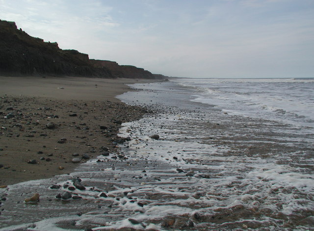
Aldbrough is a small village located in the East Riding of Yorkshire, England. Situated on the Holderness coast, it lies approximately 13 miles northeast of the city of Hull. The village is surrounded by beautiful countryside, with rolling hills and agricultural fields dominating the landscape.

Aldbrough is known for its historical significance, with evidence of a settlement dating back to Roman times. The village features several well-preserved medieval buildings, including the Grade II listed St. Bartholomew's Church, which dates back to the 12th century.

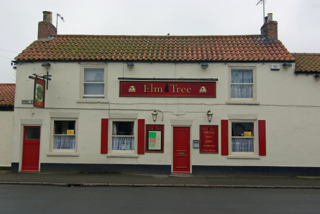
The village has a close-knit community and offers a range of amenities to its residents. These include a primary school, a village hall, a post office, and a convenience store. The village also boasts a traditional pub, the Aldbrough Arms, which is a popular gathering place for locals and visitors alike.

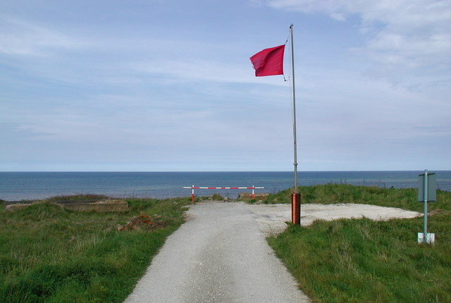
Aldbrough's coastal location makes it a popular destination for tourists and nature enthusiasts. The village is surrounded by breathtaking natural beauty, with stunning views of the North Sea and the opportunity to explore the nearby Spurn National Nature Reserve. The reserve is home to a wide variety of bird species and is a haven for birdwatchers.

Overall, Aldbrough offers a tranquil and picturesque setting, steeped in history and natural beauty. It is a place where residents and visitors can enjoy the charm of a traditional English village while being surrounded by the stunning Yorkshire countryside and the rugged beauty of the coast.

If you have any feedback on the listing, please let us know in the comments section below.

Aldbrough Images

Images are sourced within 2km of 53.829724/-0.112731 or Grid Reference TA2438. Thanks to Geograph Open Source API. All images are credited.

Bewick  Hall  access  road  from  B1242 Footpath goes from access road north of the hall over fields to the Withernwick Road near Little Westhill
Bewick Hall access road from B1242
Footpath goes from access road north of the hall over fields to the Withernwick Road near Little Westhill
Footpath  over  crop  to  right  of  barn  at  Bewick  Hall Farm access road to left of line of trees
Footpath over crop to right of barn at Bewick Hall
Farm access road to left of line of trees
Walking  track  at  Bewick  Hall  Farm
Walking track at Bewick Hall Farm
Info  board  for  test  drilling  site  for  offshore  wind  turbines Well worth reading, 23 piles are driven into the soil and numerous tests are conducted over a period of months
Info board for test drilling site for offshore wind turbines
Well worth reading, 23 piles are driven into the soil and numerous tests are conducted over a period of months
Wind  Turbines  test  drilling  site Testing foundations of offshore wind turbines, 23 piles have been drilled
Wind Turbines test drilling site
Testing foundations of offshore wind turbines, 23 piles have been drilled
Test  drilling  site  for  offshore  wind  turbines On farm land north of Aldbrough. photo taken through security wire on side of access track to East Hill farm. Bridleway.
Test drilling site for offshore wind turbines
On farm land north of Aldbrough. photo taken through security wire on side of access track to East Hill farm. Bridleway.
Approaching junction with B1242 To the right, Aldborough, to the left, Mappleton.
Approaching junction with B1242
To the right, Aldborough, to the left, Mappleton.
Seaside Road View from St.Bartholomew's churchyard
Seaside Road
View from St.Bartholomew's churchyard
St. Bartholomew's church An ancient and interesting church with an 11th century (or possibly earlier) nave, a 12th century chancel and 13th century tower, all restored in the late 19th century
St. Bartholomew's church
An ancient and interesting church with an 11th century (or possibly earlier) nave, a 12th century chancel and 13th century tower, all restored in the late 19th century
Priest's door What appears to be a 13th century priest's door in St.Bartholomew's church <a title="https://www.geograph.org.uk/photo/2308747" href="https://www.geograph.org.uk/photo/2308747">Link</a> with re-used 12th century chevron moulding above
Priest's door
What appears to be a 13th century priest's door in St.Bartholomew's church Link with re-used 12th century chevron moulding above
The end of the road An abrupt end to Seaside Road at Mount Pleasant as coastal erosion takes its toll
The end of the road
An abrupt end to Seaside Road at Mount Pleasant as coastal erosion takes its toll
Land's end A precipitous drop over the North Cliff lies beyond the end of Seaside Road <a title="https://www.geograph.org.uk/photo/2309841" href="https://www.geograph.org.uk/photo/2309841">Link</a> as coastal erosion carves away at the Holderness coast
Land's end
A precipitous drop over the North Cliff lies beyond the end of Seaside Road Link as coastal erosion carves away at the Holderness coast
Road closed The access road to the caravan park has slipped further towards the North Sea  since November 2010 <a title="https://www.geograph.org.uk/photo/2152497" href="https://www.geograph.org.uk/photo/2152497">Link</a>
Road closed
The access road to the caravan park has slipped further towards the North Sea since November 2010 Link
Carlton Lane in Aldbrough
General Dealer in Hornsea Road, Aldbrough
Garden equipment and DIY store in Aldbrough
Who Would Want To? This is the end of the road from Aldbrough village to the North Sea coastline.  The road gets shorter by about 4m every year and part of it, as seen in this picture, is half way down the cliff..... complete with its double yellow lines!  Would you want to park on this section?...... I certainly wouldn't!!
Who Would Want To?
This is the end of the road from Aldbrough village to the North Sea coastline. The road gets shorter by about 4m every year and part of it, as seen in this picture, is half way down the cliff..... complete with its double yellow lines! Would you want to park on this section?...... I certainly wouldn't!!
Telephone Exchange, Aldbrough Situated on the B1242 Hornsea Road, this redbrick TE provides telephone and broadband services to Aldbrough plus Flinton, Garton, Great Cowden, West Newton and Withernwick nearby. It has (01964) 527xxx numbers and its postcode is HU11 4QW.
Telephone Exchange, Aldbrough
Situated on the B1242 Hornsea Road, this redbrick TE provides telephone and broadband services to Aldbrough plus Flinton, Garton, Great Cowden, West Newton and Withernwick nearby. It has (01964) 527xxx numbers and its postcode is HU11 4QW.
Show me another place!

Aldbrough is located at Grid Ref: TA2438 (Lat: 53.829724, Lng: -0.112731)

Division: East Riding

Unitary Authority: East Riding of Yorkshire

Police Authority: Humberside

What 3 Words

///glance.squish.managers. Near Aldbrough, East Yorkshire

Nearby Locations

Sandpit Hill Aldbrough

Related Wikis

Aldbrough, East Riding of Yorkshire

Aldbrough is a village and civil parish in the East Riding of Yorkshire, England, about 12 miles (19 km) north-east of Hull at the junction of the B1242...

Cowden, East Riding of Yorkshire

Cowden (or Little Cowden) is a hamlet in the East Riding of Yorkshire, England, in an area known as Holderness. It is situated approximately 5 miles (8...

Etherdwick

Etherdwick is a hamlet in the East Riding of Yorkshire, England in an area known as Holderness. It is approximately 9 miles (14 km) north-west of Withernsea...

RAF Cowden

RAF Cowden was a Royal Air Force bombing range, near to the village of Aldbrough, East Riding of Yorkshire, England. The site was used by the RAF and other...

Nearby Amenities

Located within 500m of 53.829724,-0.112731
Aldbrough
Is In: East Riding of Yorkshire, England, UK
Is In County: East Riding of Yorkshire
Place: village
Lat/Long: 53.827699/-0.1142214
Wentworth House Hotel
Phone: +44 1964 527246
Tourism: hotel
Lat/Long: 53.8297624/-0.1095311
Post Office
Aldbrough Post Office
Addr City: Hull
Addr Housenumber: 4
Addr Postcode: HU11 4RN
Addr Street: Church Street
Addr Village: Aldbrough
Brand: Post Office
Brand Wikidata: Q1783168
Opening Hours: Mo-Su 07:00-21:00
Ref Pol Id: 3048
Website: https://www.postoffice.co.uk/branch-finder/1533215/aldbrough
Lat/Long: 53.8296689/-0.1128053
Historic: memorial
Lat/Long: 53.8297441/-0.1131564
Power: substation
Lat/Long: 53.830111/-0.1143063
Bus Stop
Aldbrough High Street
Naptan AtcoCode: 2200YEA00692
Naptan Bearing: E
Naptan CommonName: Aldbrough High Street
Naptan Landmark: Outside Number 27
Naptan Street: High Street
Naptan Verified: no
Source: naptan_import
Lat/Long: 53.8286993/-0.1135259
Bus Stop
Albrough High Street
Naptan AtcoCode: 2200YEA00693
Naptan Bearing: W
Naptan CommonName: Albrough High Street
Naptan Landmark: Outside Number 34
Naptan Street: High Street
Naptan Verified: no
Source: naptan_import
Lat/Long: 53.8285912/-0.1135156
Bus Stop
Aldbrough Headlands Road
Naptan AtcoCode: 2200YEA00694
Naptan Bearing: E
Naptan CommonName: Aldbrough Headlands Road
Naptan Landmark: Outside Number 25
Naptan Street: Headlands Road
Naptan Verified: no
Source: naptan_import
Lat/Long: 53.8286711/-0.1105944
Bus Stop
Aldbrough Church Street
Naptan AtcoCode: 2200YEA00697
Naptan Bearing: E
Naptan CommonName: Aldbrough Church Street
Naptan Landmark: St Bartholomew'S Church
Naptan Street: Church Street
Naptan Verified: no
Source: naptan_import
Lat/Long: 53.8296322/-0.1111134
Bus Stop
Aldbrough North Street
Naptan AtcoCode: 2200YEA00698
Naptan Bearing: E
Naptan CommonName: Aldbrough North Street
Naptan Landmark: Near Number 1 (Dairy Farm)
Naptan Street: Church Street
Naptan Verified: no
Source: naptan_import
Lat/Long: 53.8298332/-0.1130342
Bus Stop
Aldbrough Hornsea Road
Naptan AtcoCode: 2200YEA00700
Naptan Bearing: NW
Naptan CommonName: Aldbrough Hornsea Road
Naptan Landmark: Near Aldbrough Hall
Naptan Street: Hornsea Road
Naptan Verified: no
Source: naptan_import
Lat/Long: 53.8279008/-0.1159171
Bus Stop
Aldbrough Hornsea Road
Naptan AtcoCode: 2200YEA00701
Naptan Bearing: S
Naptan CommonName: Aldbrough Hornsea Road
Naptan Landmark: Near Number 4
Naptan Street: Hornsea Road
Naptan Verified: no
Source: naptan_import
Lat/Long: 53.8279159/-0.1157341
Sandpit Hil
Natural: peak
Source: OS 1:25k
Lat/Long: 53.8322968/-0.1084478
Fast Food
Aldbrough Fisheries
Cuisine: fish_and_chips
Lat/Long: 53.8287174/-0.1162245
Mill Hill
Natural: peak
Lat/Long: 53.8338312/-0.1148799
Power: pole
Lat/Long: 53.8311559/-0.1158126
Power: pole
Lat/Long: 53.827898/-0.1066662
Power: pole
Lat/Long: 53.8316462/-0.106663
Power: pole
Lat/Long: 53.8311115/-0.1169766
Power: pole
Lat/Long: 53.83133/-0.1122345
Power: pole
Lat/Long: 53.8276871/-0.1067274
Power: pole
Lat/Long: 53.8283931/-0.1072182
Power: pole
Lat/Long: 53.8314024/-0.1109974
Power: pole
Lat/Long: 53.8316023/-0.1077498
Line Management: termination
Location Transition: yes
Power: pole
Lat/Long: 53.8289048/-0.107774
Telephone
Booth: K6
Covered: booth
Man Made: telephone_box
Old Phone: +44 1964 527225
Lat/Long: 53.8285811/-0.1128099
Defibrillator
Defibrillator Location: outside Aldborough Primary School
Emergency: defibrillator
Indoor: no
Lat/Long: 53.8285404/-0.1111437
Bench
Lat/Long: 53.8285654/-0.112537
The data included in this document is from www.openstreetmap.org. The data is made available under ODbL.

Have you been to Aldbrough?

Leave your review of Aldbrough below (or comments, questions and feedback).