Wroxton

Settlement in Oxfordshire Cherwell

England

Wroxton

Stratford Road bridge and Balscote ironstone quarry The bridge parapet in the foreground is that of a bridge under the Stratford Road built in 1954 to allow the Oxfordshire Ironstone Quarries to extract the ironstone from the land visible beyond.  This was the Balscote Quarry which was worked between 1956 and the closure of the entire quarry system in 1967. The bridge provided a link for removal of ironstone via the quarry railway network back to <a href="https://www.geograph.org.uk/photo/199178">SP4042 : Oxfordshire Ironstone Quarries Headquarters site</a> at Wroxton for processing.
Stratford Road bridge and Balscote ironstone quarry Credit: David Stowell

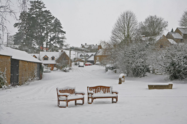
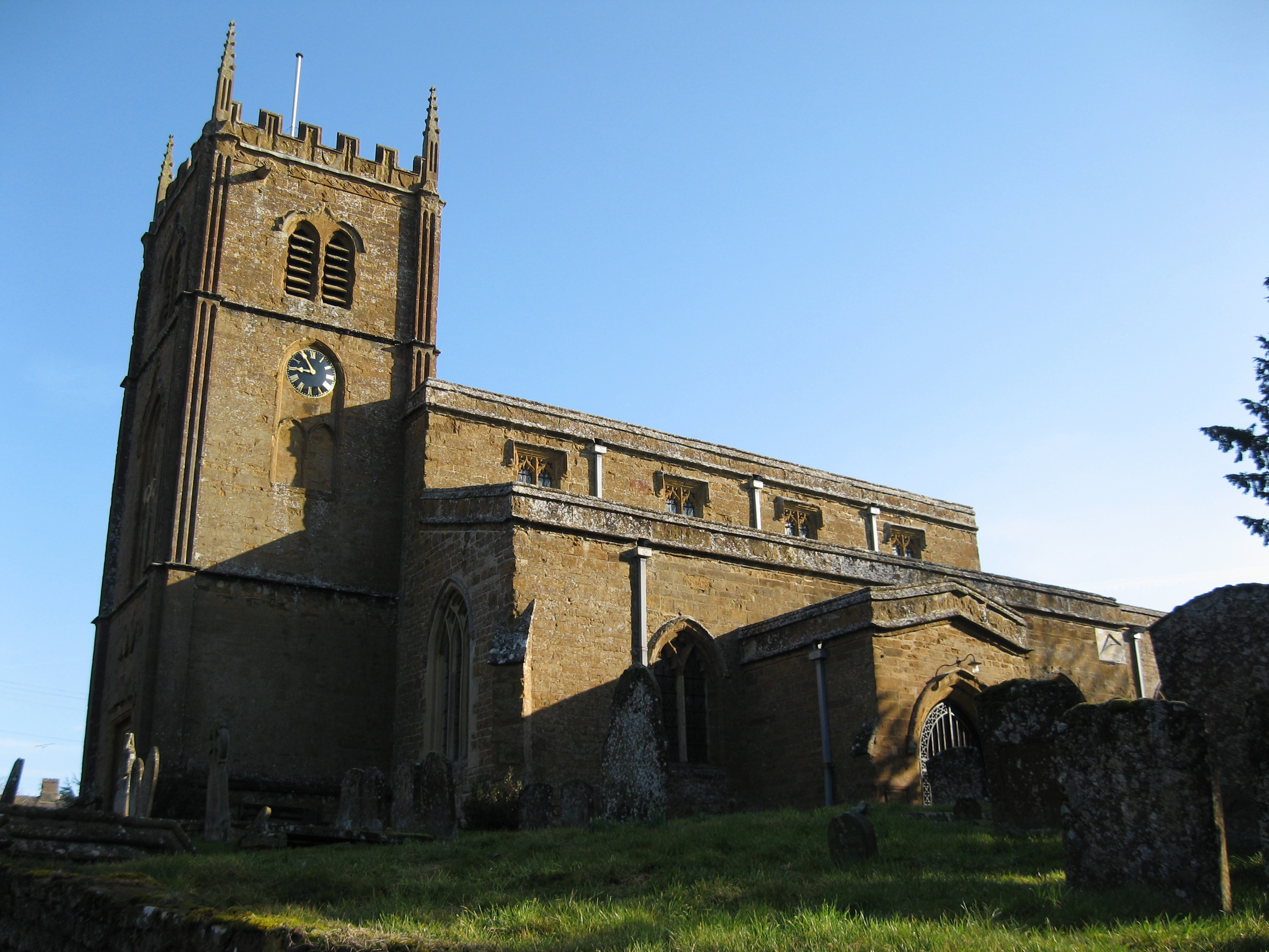
Wroxton is a picturesque village located in the Cherwell Valley of Oxfordshire, England. Situated approximately 20 miles north of Oxford, Wroxton is a quintessential English countryside village with its charming thatched-roof cottages, rolling green fields, and peaceful atmosphere.

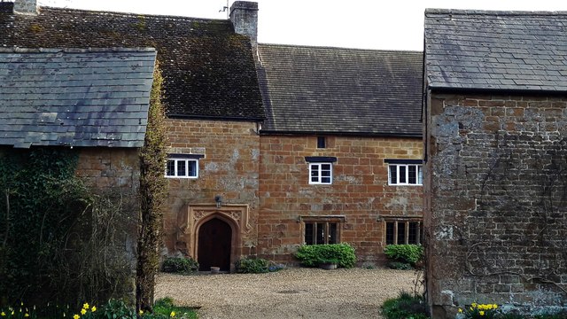
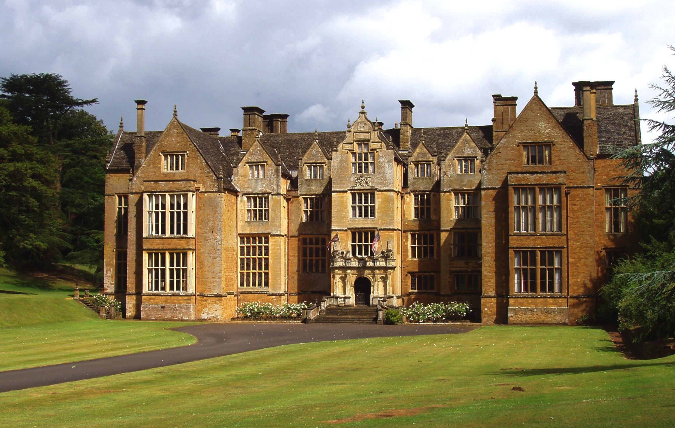
The village is home to around 200 residents and is renowned for its historical significance. The centerpiece of Wroxton is undoubtedly Wroxton Abbey, a beautiful Jacobean mansion that has been converted into a college for American students. The abbey's history dates back to the 12th century when it was founded as a priory. Over the years, it has been expanded and renovated, resulting in its current grandeur.

Wroxton Abbey is set within stunning gardens and parkland, which are open to the public during certain times of the year. Visitors can explore the immaculately maintained grounds, admire the beautiful architecture, and learn about the abbey's rich history.

Aside from its historical attractions, Wroxton offers a range of amenities to its residents and visitors. The village has a post office, a village hall, a primary school, and a popular pub, The Wroxton House Hotel, which offers a warm and welcoming atmosphere.

Surrounded by idyllic countryside, Wroxton is a haven for nature lovers. The village is located close to several walking and cycling routes, providing ample opportunities to explore the stunning Oxfordshire countryside.

Overall, Wroxton is a charming village that seamlessly blends history, natural beauty, and a sense of community, making it an enchanting destination for both locals and tourists alike.

If you have any feedback on the listing, please let us know in the comments section below.

Wroxton Images

Images are sourced within 2km of 52.073792/-1.4014657 or Grid Reference SP4141. Thanks to Geograph Open Source API. All images are credited.

Stratford Road bridge and Balscote ironstone quarry The bridge parapet in the foreground is that of a bridge under the Stratford Road built in 1954 to allow the Oxfordshire Ironstone Quarries to extract the ironstone from the land visible beyond.  This was the Balscote Quarry which was worked between 1956 and the closure of the entire quarry system in 1967. The bridge provided a link for removal of ironstone via the quarry railway network back to <a href="https://www.geograph.org.uk/photo/199178">SP4042 : Oxfordshire Ironstone Quarries Headquarters site</a> at Wroxton for processing.
Stratford Road bridge and Balscote ironstone quarry
The bridge parapet in the foreground is that of a bridge under the Stratford Road built in 1954 to allow the Oxfordshire Ironstone Quarries to extract the ironstone from the land visible beyond. This was the Balscote Quarry which was worked between 1956 and the closure of the entire quarry system in 1967. The bridge provided a link for removal of ironstone via the quarry railway network back to SP4042 : Oxfordshire Ironstone Quarries Headquarters site at Wroxton for processing.
Golf course at Wroxton Mill This course is not shown on the OS Map and is discreetly hidden away in the little valley above Wroxton Mill.
Golf course at Wroxton Mill
This course is not shown on the OS Map and is discreetly hidden away in the little valley above Wroxton Mill.
Balscote A marker stone commemorating the millennium situated on a green in the SE corner of the village.
Balscote
A marker stone commemorating the millennium situated on a green in the SE corner of the village.
Site of Langley Ironstone Quarry The whole of the area in this picture as far as the woods and the far lines of trees was quarried for ironstone between 1926 and 1943.  The ironstone was not far below the surface and as it was removed the land was returned to cultivation - but 15-20 metres below its previous level.  This view is from the bridge constructed under the Stratford Road in 1954 to allow access to open up the Balscott Quarry area.  The shallow depression across the fields leading away from the photographer marks the course of the railway from the newer quarry area back to the <a href="https://www.geograph.org.uk/photo/199178">SP4042 : Oxfordshire Ironstone Quarries Headquarters site</a> which is just visible to the right of the woodland in the centre of the picture.
Site of Langley Ironstone Quarry
The whole of the area in this picture as far as the woods and the far lines of trees was quarried for ironstone between 1926 and 1943. The ironstone was not far below the surface and as it was removed the land was returned to cultivation - but 15-20 metres below its previous level. This view is from the bridge constructed under the Stratford Road in 1954 to allow access to open up the Balscott Quarry area. The shallow depression across the fields leading away from the photographer marks the course of the railway from the newer quarry area back to the SP4042 : Oxfordshire Ironstone Quarries Headquarters site which is just visible to the right of the woodland in the centre of the picture.
Balscote (or Balscott) in the Snow Looking up from 'The Slade' towards Manor Farm Lane.
Balscote (or Balscott) in the Snow
Looking up from 'The Slade' towards Manor Farm Lane.
Skyline trees catch the evening sun There several groups of pine trees planted in and around Balscott. Anybody know when and why?
Skyline trees catch the evening sun
There several groups of pine trees planted in and around Balscott. Anybody know when and why?
Balscott in the Snow (February 2007) A similar view to the 2003 shot on here.
Balscott in the Snow (February 2007)
A similar view to the 2003 shot on here.
Footpath near Wroxton Mill
Clear footpath Clear footpath from Ragnell Bottom across the field up to road near Ragnell farm
Clear footpath
Clear footpath from Ragnell Bottom across the field up to road near Ragnell farm
Turning for Balscott
Stratford Road towards Edgehill
Lane towards A422 A recently trimmed hedge.
Lane towards A422
A recently trimmed hedge.
Lane towards Hornton Running along the top of the high ground formerly much quarried for ironstone.
Lane towards Hornton
Running along the top of the high ground formerly much quarried for ironstone.
Manor Farm Lane, Balscote Three lanes descend from the road through Balscote to a village green at the bottom, seen towards the right of the picture with trees beyond it.
Manor Farm Lane, Balscote
Three lanes descend from the road through Balscote to a village green at the bottom, seen towards the right of the picture with trees beyond it.
Priory Farm, Balscote Priory Farm abuts the village green to the south.
Priory Farm, Balscote
Priory Farm abuts the village green to the south.
From Balscote village green The backs of houses on Chapel Lane.
From Balscote village green
The backs of houses on Chapel Lane.
Looking down Chapel Lane, Balscote Balscote Grange Farmhouse is on the right, incorporating some 15th or 16th century work as the doorway suggests.
Looking down Chapel Lane, Balscote
Balscote Grange Farmhouse is on the right, incorporating some 15th or 16th century work as the doorway suggests.
Buildings at Priory Farm Priory farm cesed to be a working farm many years ago and is now a large residence with a tennis court and swimming pool which were installed in c. 2002.  These are out buildings some of which have been converted.
Buildings at Priory Farm
Priory farm cesed to be a working farm many years ago and is now a large residence with a tennis court and swimming pool which were installed in c. 2002. These are out buildings some of which have been converted.
Show me another place!

Wroxton is located at Grid Ref: SP4141 (Lat: 52.073792, Lng: -1.4014657)

Administrative County: Oxfordshire

District: Cherwell

Police Authority: Thames Valley

What 3 Words

///prowling.tricycle.structure. Near Banbury, Oxfordshire

Nearby Locations

Wroxton Wroxton Abbey

Related Wikis

Wroxton

Wroxton is a village and civil parish in the north of Oxfordshire about 3 miles (5 km) west of Banbury. The 2011 Census recorded the parish's population...

Wroxton Abbey

Wroxton Abbey is a Jacobean house in Oxfordshire, with a 1727 garden partly converted to the serpentine style between 1731 and 1751. It is 2.5 miles (4...

Oxfordshire Ironstone Railway

The Oxfordshire Ironstone Railway was a standard-gauge mineral railway that served an ironstone quarry near the village of Wroxton in Oxfordshire. ��2...

Balscote

Balscote or Balscott is a village in the civil parish of Wroxton, Oxfordshire, about 4 miles (6.4 km) west of Banbury. The Domesday Book of 1086 records...

Nearby Amenities

Located within 500m of 52.073792,-1.4014657
Wroxton
Place: village
Wikidata: Q2116246
Wikipedia: en:Wroxton
Lat/Long: 52.0730435/-1.3978802
Bus Stop
The Firs
Bus: yes
Naptan AtcoCode: 340000847CNR
Naptan Bearing: E
Naptan BusStopType: CUS
Naptan CommonName: The Firs
Naptan Indicator: Corner
Naptan Landmark: The Firs
Naptan NaptanCode: oxfgapjd
Naptan Street: Stratford Road
Naptan Verified: no
Public Transport: platform
Source: naptan_import
Lat/Long: 52.0741387/-1.3993305
Bus Stop
The Firs
Bus: yes
Naptan AtcoCode: 340000847V
Naptan Bearing: W
Naptan BusStopType: CUS
Naptan CommonName: The Firs
Naptan Indicator: Opposite
Naptan Landmark: The Firs
Naptan NaptanCode: oxfapjag
Naptan Street: Stratford Road
Naptan Verified: no
Public Transport: platform
Source: naptan_import
Lat/Long: 52.0738625/-1.3998303
Bus Stop
White Horse PH
Bus: yes
Naptan AtcoCode: 340000847W
Naptan Bearing: W
Naptan BusStopType: CUS
Naptan CommonName: White Horse PH
Naptan Indicator: Outside
Naptan Landmark: White Horse PH
Naptan NaptanCode: oxfgapja
Naptan Street: Stratford Road
Naptan Verified: no
Public Transport: platform
Source: naptan_import
Lat/Long: 52.0736114/-1.3946832
Bus Stop
White Horse PH
Bus: yes
Naptan AtcoCode: 340000847WO
Naptan Bearing: E
Naptan BusStopType: CUS
Naptan CommonName: White Horse PH
Naptan Indicator: Opposite
Naptan Landmark: White Horse PH
Naptan NaptanCode: oxfgapgw
Naptan Street: Stratford Road
Naptan Verified: no
Public Transport: platform
Source: naptan_import
Lat/Long: 52.0737015/-1.3947111
Well
Man Made: water_well
Source: OS_OpenData_StreetView
Lat/Long: 52.0723237/-1.406242
Power: pole
Lat/Long: 52.0741154/-1.4082458
Power: pole
Lat/Long: 52.0750617/-1.4076718
Power: pole
Lat/Long: 52.0768982/-1.4065614
Power: pole
Lat/Long: 52.0759486/-1.4071139
Power: pole
Lat/Long: 52.0762103/-1.3964901
Power: pole
Lat/Long: 52.0761715/-1.3982871
Power: pole
Lat/Long: 52.0756955/-1.3997303
Power: pole
Lat/Long: 52.0752358/-1.4011105
Power: pole
Lat/Long: 52.0745961/-1.4017752
Power: pole
Lat/Long: 52.073906/-1.4024559
Power: pole
Lat/Long: 52.0732542/-1.4035823
Power: pole
Lat/Long: 52.0718761/-1.4059484
Power: pole
Lat/Long: 52.0724384/-1.404983
Power: pole
Lat/Long: 52.0712763/-1.4069587
Power: pole
Lat/Long: 52.0752452/-1.3996243
Power: pole
Lat/Long: 52.0752308/-1.398737
Power: pole
Lat/Long: 52.0752529/-1.4009223
Power: pole
Lat/Long: 52.0752213/-1.3979055
Power: pole
Lat/Long: 52.0752051/-1.3971595
Power: pole
Lat/Long: 52.0746595/-1.3957981
Power: pole
Lat/Long: 52.0741204/-1.3944758
Power: pole
Lat/Long: 52.0749181/-1.3996701
Man Made: obelisk
Lat/Long: 52.0721045/-1.4048345
Barrier: stile
Lat/Long: 52.0721004/-1.4049794
The data included in this document is from www.openstreetmap.org. The data is made available under ODbL.

Have you been to Wroxton?

Leave your review of Wroxton below (or comments, questions and feedback).