Wick

Settlement in Wiltshire

England

Wick

Elizabeth II postbox on Salisbury Road See <a title="https://www.geograph.org.uk/photo/7318385" href="https://www.geograph.org.uk/photo/7318385">Link</a> for context.
Postbox No. SP6 340.
Elizabeth II postbox on Salisbury Road Credit: JThomas

Wick is a small village located in the county of Wiltshire, England. Situated approximately 3 miles southeast of the town of Trowbridge, Wick is nestled in a rural area surrounded by beautiful countryside. The village is part of the civil parish of Southwick and is home to a population of around 800 residents.

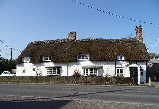
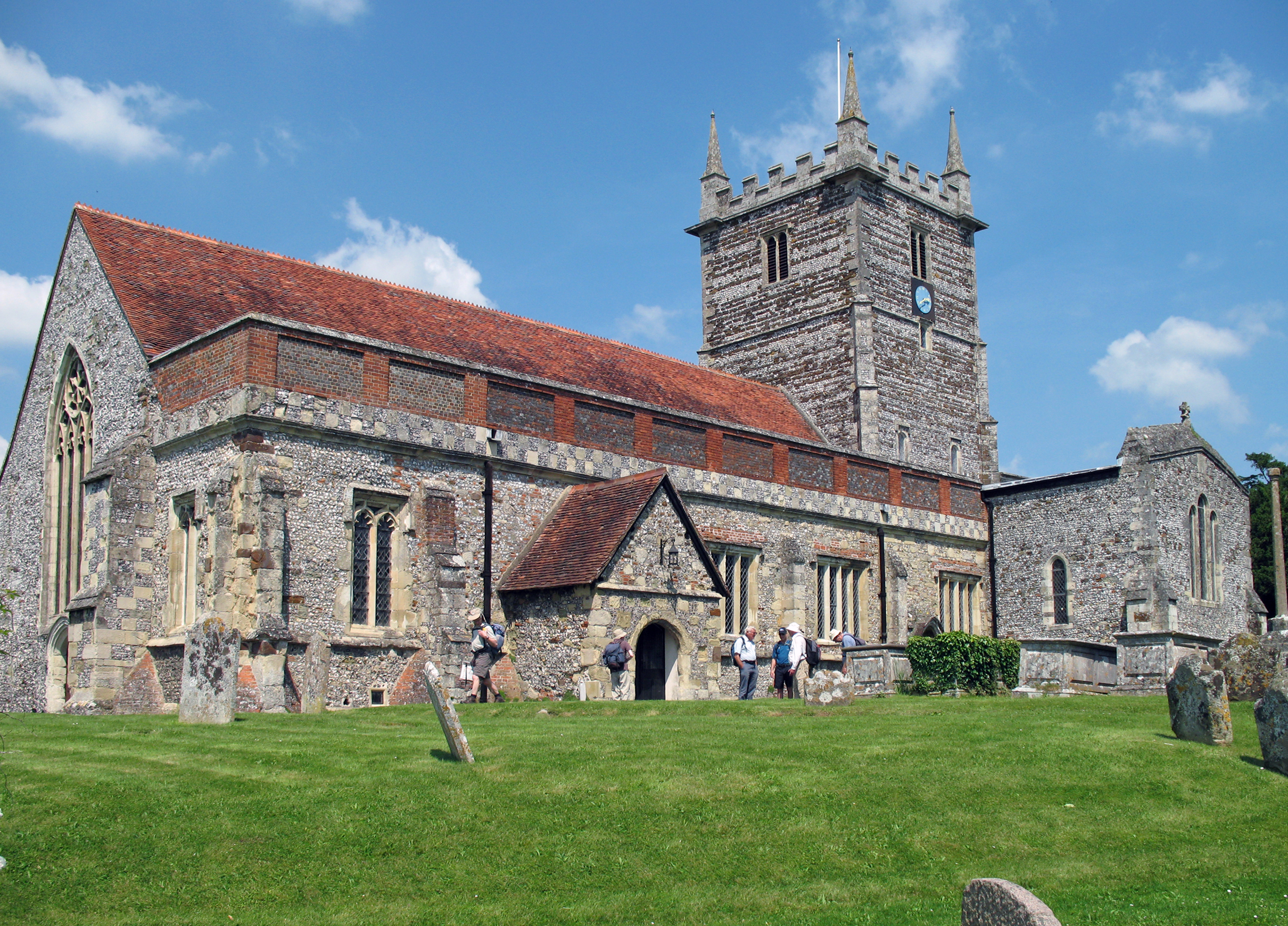
Wick boasts a rich history dating back to the medieval era, with evidence of settlements in the area since the Roman times. The village grew in prominence during the 19th century due to the expansion of the local wool industry. Today, Wick maintains its quaint charm with a collection of historic buildings, including traditional thatched cottages and the St. Lawrence Church, which dates back to the 12th century.

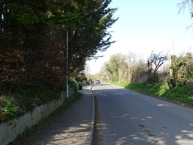
The village is well-connected, with good transportation links to nearby towns and cities. The A361 road runs through Wick, providing easy access to Trowbridge and the wider Wiltshire area. For those seeking public transportation, regular bus services connect the village to surrounding towns.

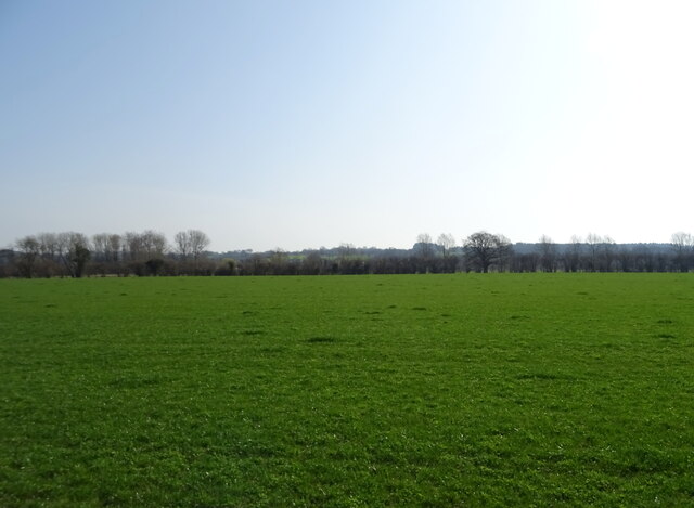
Although small in size, Wick offers a range of amenities for its residents. The village includes a primary school, a local pub, and a community center that hosts various events and activities throughout the year. The picturesque countryside surrounding Wick provides ample opportunities for outdoor recreational activities, such as hiking, cycling, and horse riding.

Overall, Wick, Wiltshire is a peaceful and charming village, offering a close-knit community, a rich history, and access to beautiful natural landscapes.

If you have any feedback on the listing, please let us know in the comments section below.

Wick Images

Images are sourced within 2km of 50.993416/-1.764645 or Grid Reference SU1621. Thanks to Geograph Open Source API. All images are credited.

Elizabeth II postbox on Salisbury Road See <a title="https://www.geograph.org.uk/photo/7318385" href="https://www.geograph.org.uk/photo/7318385">Link</a> for context.
Postbox No. SP6 340.
Elizabeth II postbox on Salisbury Road
See Link for context. Postbox No. SP6 340.
A338 towards Salisbury See <a title="https://www.geograph.org.uk/photo/7318384" href="https://www.geograph.org.uk/photo/7318384">Link</a> for postbox.
Showing position of Postbox No. SP6 340.
A338 towards Salisbury
See Link for postbox. Showing position of Postbox No. SP6 340.
The Borough, Downton View from the village cross.
The Borough, Downton
View from the village cross.
Oilseed rape crop off the A338
A338 towards Salisbury
Welcome to Wiltshire
Grazing off the A338
Entering Downton on the A338
School playing fields
Cottages on the A338
The Trafalgar School at Downton
Thatched cottages, Downton
The Bull Hotel
The Bull Hotel
Sign for the Bull Hotel
Sign on the Bull Hotel
Wick Lane
Wick Lane
Elizabeth II postbox, Downton Postbox No. SP5 198.
Elizabeth II postbox, Downton
Postbox No. SP5 198.
Service station on Salisbury Road Petrol 171.9p.
Diesel 186.9p.
Service station on Salisbury Road
Petrol 171.9p. Diesel 186.9p.
Show me another place!

Wick is located at Grid Ref: SU1621 (Lat: 50.993416, Lng: -1.764645)

Unitary Authority: Wiltshire

Police Authority: Wiltshire

What 3 Words

///deflection.foremost.mountains. Near Downton, Wiltshire

Nearby Locations

Wick

Related Wikis

Downton F.C.

Downton Football Club is a football club based in Downton, near Salisbury, Wiltshire, England. Affiliated to the Wiltshire Football Association, they are...

The Trafalgar School at Downton

The Trafalgar School at Downton is a Coeducational secondary school in Downton in the south of the English county of Wiltshire.The school began as a secondary...

Church of St Laurence, Downton

The Church of St Laurence is the main Church of England parish church for the village of Downton, Wiltshire, England. An unusually long building for a...

Downton, Wiltshire

Downton is a village and civil parish on the River Avon in southern Wiltshire, England, about 6 miles (10 km) southeast of the city of Salisbury. The parish...

Nearby Amenities

Located within 500m of 50.993416,-1.764645
Fuel
Esso
Brand: Esso
Brand Wikidata: Q867662
Website: https://www.esso.co.uk/en-gb/find-station/esso-salisbury-essoeglongford-100200440
Lat/Long: 50.9946127/-1.7589226
Downton Leisure Centre
Leisure: sports_centre
Source: bing
Lat/Long: 50.9931016/-1.7631475
Crossing
Crossing: traffic_signals
Crossing Island: no
Crossing Ref: puffin
Kerb: flush
Tactile Paving: yes
Lat/Long: 50.9932033/-1.7582175
Addr City: Salisbury
Addr Housenumber: 1
Addr Street: Haydon Close
Lat/Long: 50.9947067/-1.7598694
Addr City: Salisbury
Addr Housenumber: 2
Addr Street: Haydon Close
Lat/Long: 50.9946847/-1.7599519
Addr City: Salisbury
Addr Housenumber: 3
Addr Street: Haydon Close
Lat/Long: 50.9946594/-1.7600592
Addr City: Salisbury
Addr Housenumber: 5
Addr Street: Keeley Close
Lat/Long: 50.9946409/-1.7601814
Addr City: Salisbury
Addr Housenumber: 4
Addr Street: Keeley Close
Lat/Long: 50.9946206/-1.7603391
Addr City: Salisbury
Addr Housenumber: 3
Addr Street: Keeley Close
Lat/Long: 50.9946006/-1.7604818
Addr City: Salisbury
Addr Housenumber: 2
Addr Street: Keeley Close
Lat/Long: 50.9945846/-1.7606305
Addr City: Salisbury
Addr Housenumber: 1
Addr Place: Downton
Addr Street: Keeley Close
Lat/Long: 50.9945665/-1.7607786
Addr Housenumber: 26
Addr Street: Batchelor Way
Lat/Long: 50.994632/-1.7610164
Addr Housenumber: 28
Addr Street: Batchelor Way
Lat/Long: 50.9944927/-1.7609757
Addr Housenumber: 30
Addr Street: Batchelor Way
Lat/Long: 50.9943691/-1.7609314
Addr Housenumber: 21
Addr Street: Batchelor Way
Lat/Long: 50.9943958/-1.7606854
Addr Housenumber: 23
Addr Street: Batchelor Way
Lat/Long: 50.9943101/-1.7606624
Addr Housenumber: 32
Addr Street: Batchelor Way
Lat/Long: 50.9942577/-1.7609084
Addr Housenumber: 25
Addr Street: Batchelor Way
Lat/Long: 50.9942477/-1.7606447
Addr Housenumber: 34
Addr Street: Batchelor Way
Lat/Long: 50.9941207/-1.7609208
Addr Housenumber: 36
Addr Street: Batchelor Way
Lat/Long: 50.9940818/-1.7609013
Addr Housenumber: 27
Addr Street: Batchelor Way
Lat/Long: 50.9940985/-1.7606111
Addr Housenumber: 29
Addr Street: Batchelor Way
Lat/Long: 50.9940728/-1.7606023
Addr Housenumber: 38
Addr Street: Batchelor Way
Lat/Long: 50.9939815/-1.7608606
Addr Housenumber: 40
Addr Street: Batchelor Way
Lat/Long: 50.9939537/-1.7608447
Addr Housenumber: 42
Addr Street: Batchelor Way
Lat/Long: 50.9938991/-1.7608164
Addr Housenumber: 44
Addr Street: Batchelor Way
Lat/Long: 50.9938256/-1.7607668
Addr Housenumber: 46
Addr Street: Batchelor Way
Lat/Long: 50.9937922/-1.7607474
Addr Housenumber: 50
Addr Street: Batchelor Way
Lat/Long: 50.993683/-1.7607338
Addr Housenumber: 52, 54
Addr Street: Batchelor Way
Lat/Long: 50.9936858/-1.7608415
Addr Housenumber: 31
Addr Street: Batchelor Way
Lat/Long: 50.9938508/-1.7604468
Addr Housenumber: 33, 35, 37, 29
Addr Street: Batchelor Way
Lat/Long: 50.9938508/-1.7603074
Addr Housenumber: 41, 43, 45, 47
Addr Street: Batchelor Way
Lat/Long: 50.9938474/-1.7599037
Addr Housenumber: 49
Addr Street: Batchelor Way
Lat/Long: 50.9938457/-1.7596851
Addr Housenumber: 51
Addr Street: Batchelor Way
Lat/Long: 50.9938516/-1.7596194
Addr Housenumber: 64
Addr Street: Batchelor Way
Lat/Long: 50.9937469/-1.7594732
Addr Housenumber: 66
Addr Street: Batchelor Way
Lat/Long: 50.9937925/-1.7594732
Addr Housenumber: 68
Addr Street: Batchelor Way
Lat/Long: 50.993844/-1.7594491
Addr Housenumber: 70
Addr Street: Batchelor Way
Lat/Long: 50.9938896/-1.7594383
Addr Housenumber: 72
Addr Street: Batchelor Way
Lat/Long: 50.9940052/-1.7593887
Addr Housenumber: 74
Addr Street: Batchelor Way
Lat/Long: 50.9940534/-1.7593793
Addr Housenumber: 78
Addr Street: Batchelor Way
Lat/Long: 50.994277/-1.7593807
Addr Housenumber: 1
Addr Street: Moody Drive
Lat/Long: 50.994158/-1.7595993
Addr Housenumber: 2
Addr Street: Moody Drive
Lat/Long: 50.9942711/-1.7599895
Addr Housenumber: 4
Addr Street: Moody Drive
Lat/Long: 50.9942804/-1.760078
Addr Housenumber: 6
Addr Street: Moody Drive
Lat/Long: 50.9942829/-1.7601679
Addr Housenumber: 8
Addr Street: Moody Drive
Lat/Long: 50.9941817/-1.7603181
Addr Housenumber: 3
Addr Street: Moody Drive
Lat/Long: 50.9941454/-1.7600727
Addr Housenumber: 10
Addr Street: Moody Drive
Lat/Long: 50.994115/-1.7603101
Addr Housenumber: 5
Addr Street: Moody Drive
Lat/Long: 50.9941065/-1.7600727
Addr Housenumber: 7
Addr Street: Moody Drive
Lat/Long: 50.9940618/-1.7600727
Addr Housenumber: 53
Addr Street: Batchelor Way
Lat/Long: 50.99431/-1.7595523
Addr Housenumber: 55
Addr Street: Batchelor Way
Lat/Long: 50.9943454/-1.7595523
Addr Housenumber: 57
Addr Street: Batchelor Way
Lat/Long: 50.9943817/-1.7595537
Addr Housenumber: 80
Addr Street: Batchelor Way
Lat/Long: 50.9944003/-1.7593673
Addr Housenumber: 82
Addr Street: Batchelor Way
Lat/Long: 50.9944374/-1.7593699
Addr Housenumber: 59
Addr Street: Batchelor Way
Lat/Long: 50.9944425/-1.7595563
Addr Housenumber: 84
Addr Street: Batchelor Way
Lat/Long: 50.9944889/-1.7593713
Addr Housenumber: 61
Addr Street: Batchelor Way
Lat/Long: 50.9945058/-1.7595832
Addr Housenumber: 86
Addr Street: Batchelor Way
Lat/Long: 50.9946096/-1.7594652
Addr Housenumber: 88
Addr Street: Batchelor Way
Lat/Long: 50.9946721/-1.7595483
Addr Housenumber: 90
Addr Street: Batchelor Way
Lat/Long: 50.9947008/-1.7595939
Addr Housename: Foxtrot Manor
Addr Street: Batchelor Way
Lat/Long: 50.9949776/-1.7594571
Addr Housenumber: 4
Addr Street: Batchelor Way
Lat/Long: 50.9950215/-1.7597548
Addr Housenumber: 15
Addr Street: Batchelor Way
Lat/Long: 50.9948898/-1.7596033
Addr Housenumber: 17
Addr Street: Batchelor Way
Lat/Long: 50.9948468/-1.759732
Addr Housenumber: 6
Addr Street: Batchelor Way
Lat/Long: 50.9949953/-1.7598407
Addr Housenumber: 2
Addr Street: Batchelor Way
Lat/Long: 50.995172/-1.75948
Addr Housenumber: 9
Addr Street: Batchelor Way
Lat/Long: 50.9950367/-1.7592828
Addr Housenumber: 3
Addr Street: Batchelor Way
Lat/Long: 50.9950755/-1.7588134
Addr Housenumber: 1
Addr Street: Batchelor Way
Lat/Long: 50.9949616/-1.7587919
Addr Housenumber: 7
Addr Street: Batchelor Way
Lat/Long: 50.9949591/-1.7589193
FIXME: check whether 5 and 7
Addr Housenumber: 5
Addr Street: Batchelor Way
Lat/Long: 50.9950654/-1.7589327
Addr Housename: Riverside House
Lat/Long: 50.9953271/-1.7588965
Addr Housenumber: 8
Addr Street: Batchelor Way
Lat/Long: 50.9949565/-1.7599453
Addr Housename: White House
Addr Housenumber: 10
Addr Street: Batchelor Way
Lat/Long: 50.9949481/-1.7600512
Addr Housenumber: 12
Addr Street: Batchelor Way
Lat/Long: 50.9949531/-1.7602497
Addr Housenumber: 14
Addr Street: Batchelor Way
Lat/Long: 50.9949591/-1.7604401
Addr Housenumber: 16
Addr Street: Batchelor Way
Lat/Long: 50.994932/-1.7606775
Addr Housenumber: 18
Addr Street: Batchelor Way
Lat/Long: 50.9948957/-1.760758
Addr Housenumber: 20
Addr Street: Batchelor Way
Lat/Long: 50.9948628/-1.7608733
Addr Housenumber: 22
Addr Street: Batchelor Way
Lat/Long: 50.9949025/-1.7610423
Addr Housenumber: 24
Lat/Long: 50.9948198/-1.7610316
Addr Housenumber: 1
Addr Street: Bundy Grove
Lat/Long: 50.994656/-1.7613548
Addr Housenumber: 7
Addr Street: Bundy Grove
Lat/Long: 50.9947961/-1.7613668
Addr Housenumber: 2
Addr Street: Bundy Grove
Lat/Long: 50.9946603/-1.761564
Addr Housenumber: 6
Addr Street: Bundy Grove
Lat/Long: 50.9947919/-1.7615801
Addr Housenumber: 3
Addr Street: Bundy Grove
Lat/Long: 50.9946451/-1.7617826
Addr Housenumber: 5
Addr Street: Bundy Grove
Lat/Long: 50.9948189/-1.7619274
Addr Housenumber: 4
Addr Street: Bundy Grove
Lat/Long: 50.9947041/-1.7619207
Addr Housenumber: ?
Addr Street: Batchelor Way
Lat/Long: 50.993616/-1.7607845
Addr Housenumber: 56, 58, 60, 62
Addr Street: Batchelor Way
Lat/Long: 50.9936316/-1.7592662
Bicycle Parking
Access: yes
Bicycle Parking: stands
Capacity: 8
Covered: no
Fee: no
Lat/Long: 50.9931319/-1.7583021
Post Box
Operator: Royal Mail
Post Box Type: wall
Ref: SP5 323
Royal Cypher: GR
Royal Cypher Wikidata: Q33102273
Lat/Long: 50.9935361/-1.7674155
Bus Stop
Downton, The Bull
Bench: yes
Bin: yes
Bus: yes
Naptan AtcoCode: 4600WIA12145
Naptan Bearing: S
Naptan CommonName: The Bull
Naptan Indicator: S-bound
Naptan NaptanCode: wildjgmd
Naptan Street: The Headlands
Naptan Verified: no
Public Transport: platform
Shelter: yes
Tactile Paving: no
Lat/Long: 50.9925873/-1.7579124
Bus Stop
Downton, The Bull
Bench: yes
Bin: no
Bus: yes
Naptan AtcoCode: 4600WIA12144
Naptan Bearing: N
Naptan CommonName: The Bull
Naptan Indicator: N-bound
Naptan NaptanCode: wildjgjw
Naptan Street: The Headlands
Naptan Verified: no
Public Transport: platform
Shelter: yes
Tactile Paving: no
Lat/Long: 50.9930636/-1.758281
Access: yes
Entrance: yes
Shop: farm
Wheelchair: yes
Lat/Long: 50.9938483/-1.7677059
Wick
Place: quarter
Lat/Long: 50.9922811/-1.7601266
Asda Express
Addr City: Salisbury
Addr Country: GB
Addr Postcode: SP5 3HZ
Addr Street: Salisbury Road
Branch: Longford
Brand: Asda Express
Brand Wikidata: Q114826023
Fhrs Id: 263325
Shop: convenience
Website: https://storelocator.asda.com/south-west/salisbury/salisbury-road
Lat/Long: 50.9946022/-1.7589905
The data included in this document is from www.openstreetmap.org. The data is made available under ODbL.

Have you been to Wick?

Leave your review of Wick below (or comments, questions and feedback).