Albro Castle

Settlement in Pembrokeshire

Wales

Albro Castle

Footbridge over the Teifi Footbridge crossing the River Teifi beside Cardigan Bridge
Footbridge over the Teifi Credit: Philip Halling

Albro Castle, located in Pembrokeshire, Wales, is a historic site that dates back to the 12th century. Nestled on a hilltop, the castle offers breathtaking views of the surrounding countryside and the scenic Cleddau estuary.

Originally built as a timber fortress, Albro Castle was commissioned by William FitzMartin, a Norman knight, in the late 1100s. Over the centuries, the castle underwent various renovations and expansions, resulting in the unique blend of architectural styles seen today, including Norman, Gothic, and Tudor influences.

The castle's most prominent feature is its striking square tower, which stands tall at four stories high. The sturdy walls, made of local limestone, create a sense of grandeur and strength. Visitors can explore the castle's interior, which boasts a maze of rooms, including a great hall, a chapel, and living quarters. The castle's historical significance is also evident in its original medieval features, such as arrow slits and a drawbridge.

Surrounding the castle are beautiful gardens, offering a tranquil space to relax and enjoy the peaceful atmosphere. The gardens feature well-maintained lawns, vibrant flowerbeds, and a variety of trees and shrubs. Additionally, there is a small pond where wildlife can be observed.

Albro Castle is open to the public, allowing visitors to immerse themselves in its rich history and architectural beauty. Guided tours are available, providing insight into the castle's past and its connection to the local area. The castle also hosts events and exhibitions, making it a popular destination for history enthusiasts and tourists alike.

If you have any feedback on the listing, please let us know in the comments section below.

Albro Castle Images

Images are sourced within 2km of 52.081695/-4.6867064 or Grid Reference SN1646. Thanks to Geograph Open Source API. All images are credited.

Footbridge over the Teifi Footbridge crossing the River Teifi beside Cardigan Bridge
Footbridge over the Teifi
Footbridge crossing the River Teifi beside Cardigan Bridge
Bridge crossing the Teifi Cardigan Bridge carrying traffic over the River Teifi on the right and the pedestrian footbridge on the left.
Bridge crossing the Teifi
Cardigan Bridge carrying traffic over the River Teifi on the right and the pedestrian footbridge on the left.
Cardigan Bridge Cardigan Bridge crosses Afon Teifi and is thought to date from the early 18th century.  The bridge was enlarged in the 1870s as traffic levels increased.
Cardigan Bridge
Cardigan Bridge crosses Afon Teifi and is thought to date from the early 18th century. The bridge was enlarged in the 1870s as traffic levels increased.
Cardigan Castle Cardigan Castle viewed from across Afon Teifi.
Cardigan Castle
Cardigan Castle viewed from across Afon Teifi.
Adventure Activities Adventure Activities on the banks of Afon Teifi in Cardigan.
Adventure Activities
Adventure Activities on the banks of Afon Teifi in Cardigan.
Boats on Afon Teifi Moored boats reflected in the waters of Afon Teifi.  The tide coming in.
Boats on Afon Teifi
Moored boats reflected in the waters of Afon Teifi. The tide coming in.
Boats on Afon Teifi Moored boats reflected in the waters of Afon Teifi.  The tide is coming in.
Boats on Afon Teifi
Moored boats reflected in the waters of Afon Teifi. The tide is coming in.
Afon Teifi Boats moored on Afon Teifi with the tide coming in.
Afon Teifi
Boats moored on Afon Teifi with the tide coming in.
The Teifi Otter A sculpted otter beside Afon Teifi in Cardigan.  The inscription on a plaque reads:

'Presented to Cardigan by Dr David Bellamy
on behalf of the Dyfed Wildlife Trust
to mark its golden jubilee 1938-1988'

Sculpted by Geoffrey Powell.
The Teifi Otter
A sculpted otter beside Afon Teifi in Cardigan. The inscription on a plaque reads: 'Presented to Cardigan by Dr David Bellamy on behalf of the Dyfed Wildlife Trust to mark its golden jubilee 1938-1988' Sculpted by Geoffrey Powell.
Bus stop in Cardigan This is the main bus stop in Cardigan.  Memory is a funny thing walking through this bus stop, it triggered a dormant memory of being here before in March 1987 and catching a bus to Carmarthen at the end of a week walking some of the Pembrokeshire coast path.  A memory until this moment had slipped from my mind.
Bus stop in Cardigan
This is the main bus stop in Cardigan. Memory is a funny thing walking through this bus stop, it triggered a dormant memory of being here before in March 1987 and catching a bus to Carmarthen at the end of a week walking some of the Pembrokeshire coast path. A memory until this moment had slipped from my mind.
Priory Street and the Town Hall A view along Priory Street to Cardigan's Town Hall.
Priory Street and the Town Hall
A view along Priory Street to Cardigan's Town Hall.
Pilot Street Pilot Street in St Dogmaels.
Pilot Street
Pilot Street in St Dogmaels.
Sports field Sports field at St Dogmaels.
Sports field
Sports field at St Dogmaels.
St Thomas the Apostle church, St Dogmaels St Thomas the Apostle church in St Dogmaels is situated next to the ruins of St Dogmaels Abbey precincts.  The church was built in 1847.
St Thomas the Apostle church, St Dogmaels
St Thomas the Apostle church in St Dogmaels is situated next to the ruins of St Dogmaels Abbey precincts. The church was built in 1847.
The ruins of St Dogmaels Abbey The remains of the north transepts of St Dogmaels Abbey.
The ruins of St Dogmaels Abbey
The remains of the north transepts of St Dogmaels Abbey.
St Dogmaels Abbey The ruins of the monastic buildings at St Dogmaels Abbey.
St Dogmaels Abbey
The ruins of the monastic buildings at St Dogmaels Abbey.
St Dogmaels Abbey The ruins of St Dogmaels Abbey.
St Dogmaels Abbey
The ruins of St Dogmaels Abbey.
Sculpture of St Dogmael Sculpture of St Dogmael opposite the abbey ruins.
Sculpture of St Dogmael
Sculpture of St Dogmael opposite the abbey ruins.
Show me another place!

Albro Castle is located at Grid Ref: SN1646 (Lat: 52.081695, Lng: -4.6867064)

Unitary Authority: Ceredigion

Police Authority: Dyfed Powys

What 3 Words

///shame.altitude.tidy. Near Cardigan, Ceredigion

Related Wikis

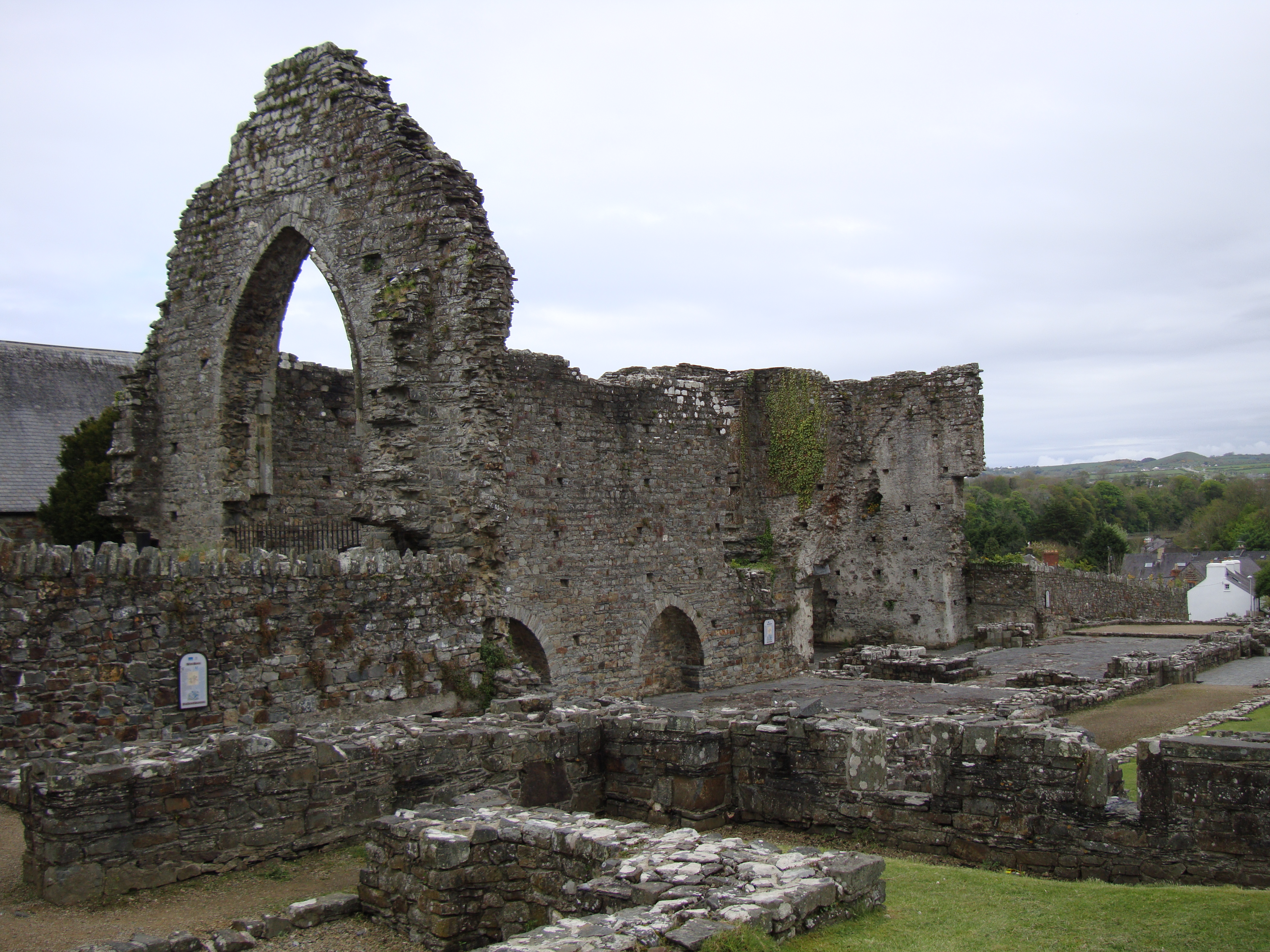
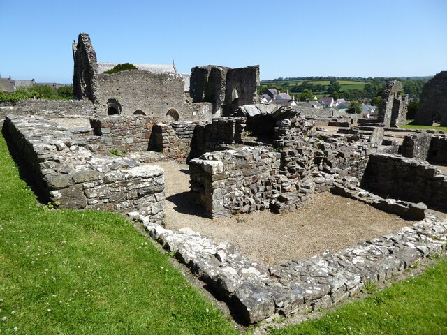
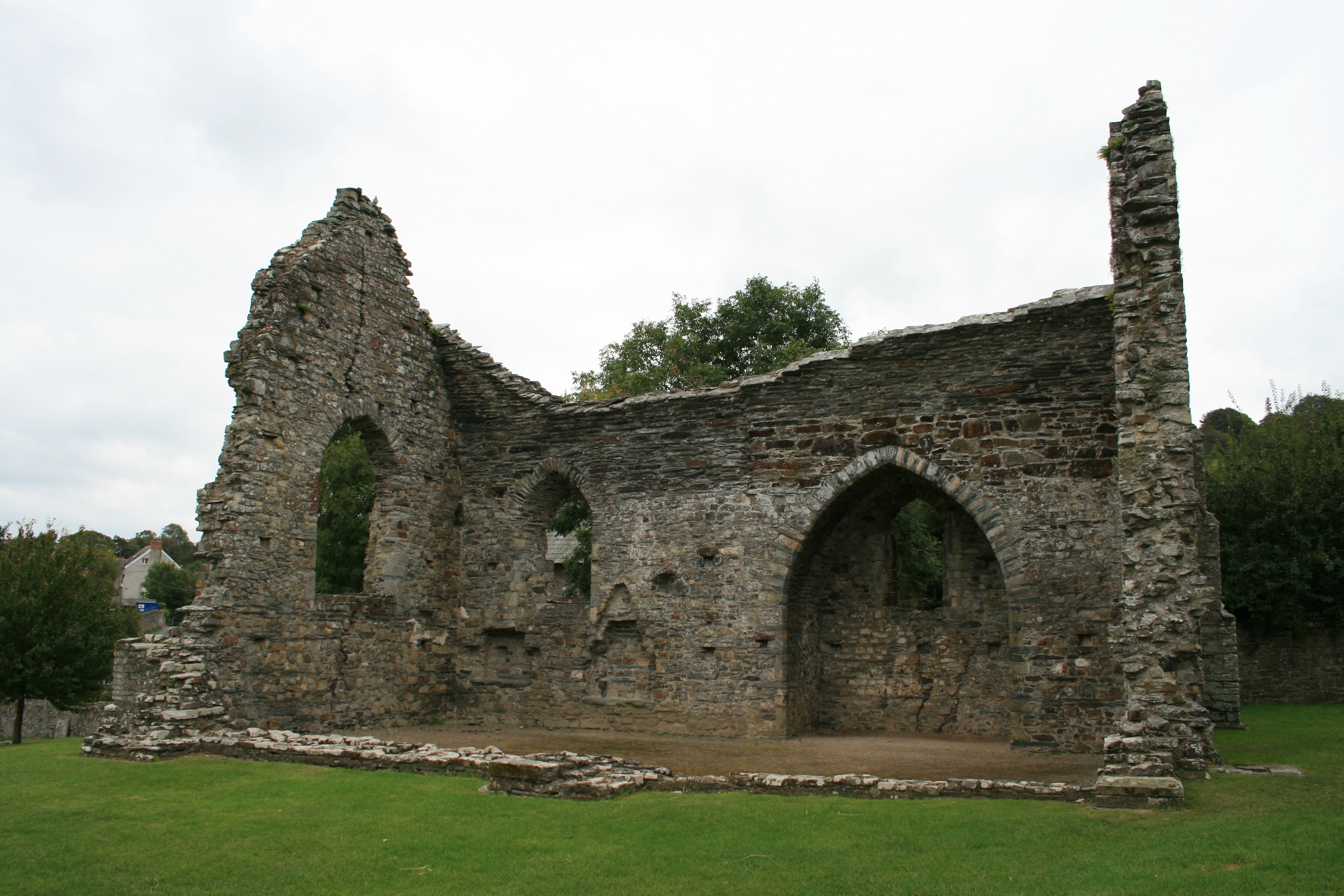
Abbey of St Mary, St Dogmaels

The Abbey of St Mary (also known as St Dogmaels Abbey) is Grade I listed ruined abbey in St Dogmaels in Pembrokeshire, Wales, on the banks of the River...

St Dogmaels

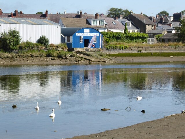
St Dogmaels (Welsh: Llandudoch) is a village, parish and community in Pembrokeshire, Wales, on the estuary of the River Teifi, a mile downstream from the...

St Dogmaels television relay station

The St Dogmaels television relay station is a broadcasting and telecommunications facility located just above the village of St Dogmaels in Pembrokeshire...
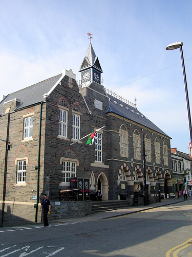
Cardigan Guildhall

Cardigan Guildhall (Welsh: Neuadd y Dref Aberteifi), is a municipal building in Pendre, Cardigan, Ceredigion, Wales. The structure, which is now used as...
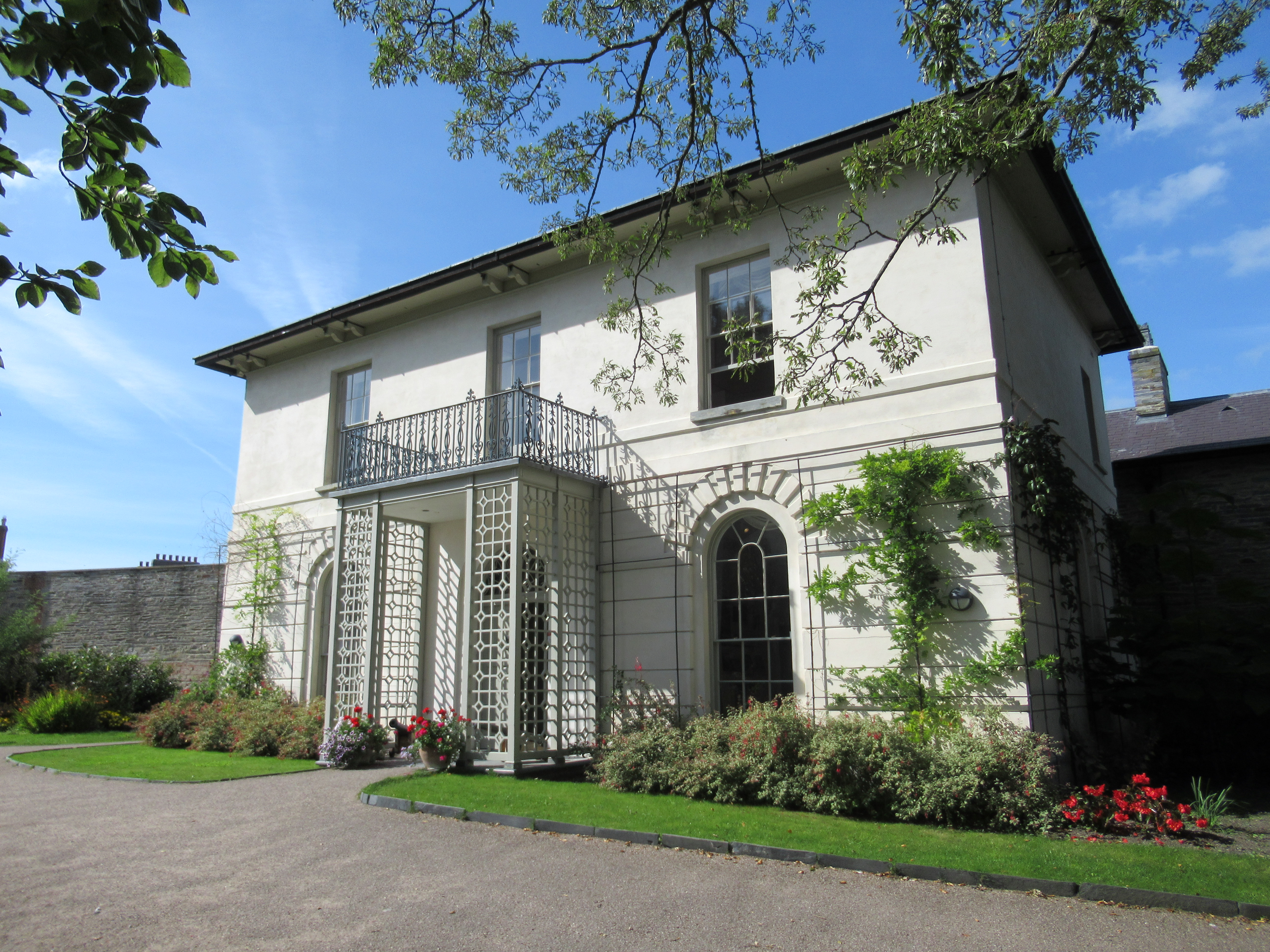
Castle Green House

Castle Green House is a Grade II* listed house located in the grounds of Cardigan Castle, Cardigan, Ceredigion, Wales. It was restored in the 2000s and...
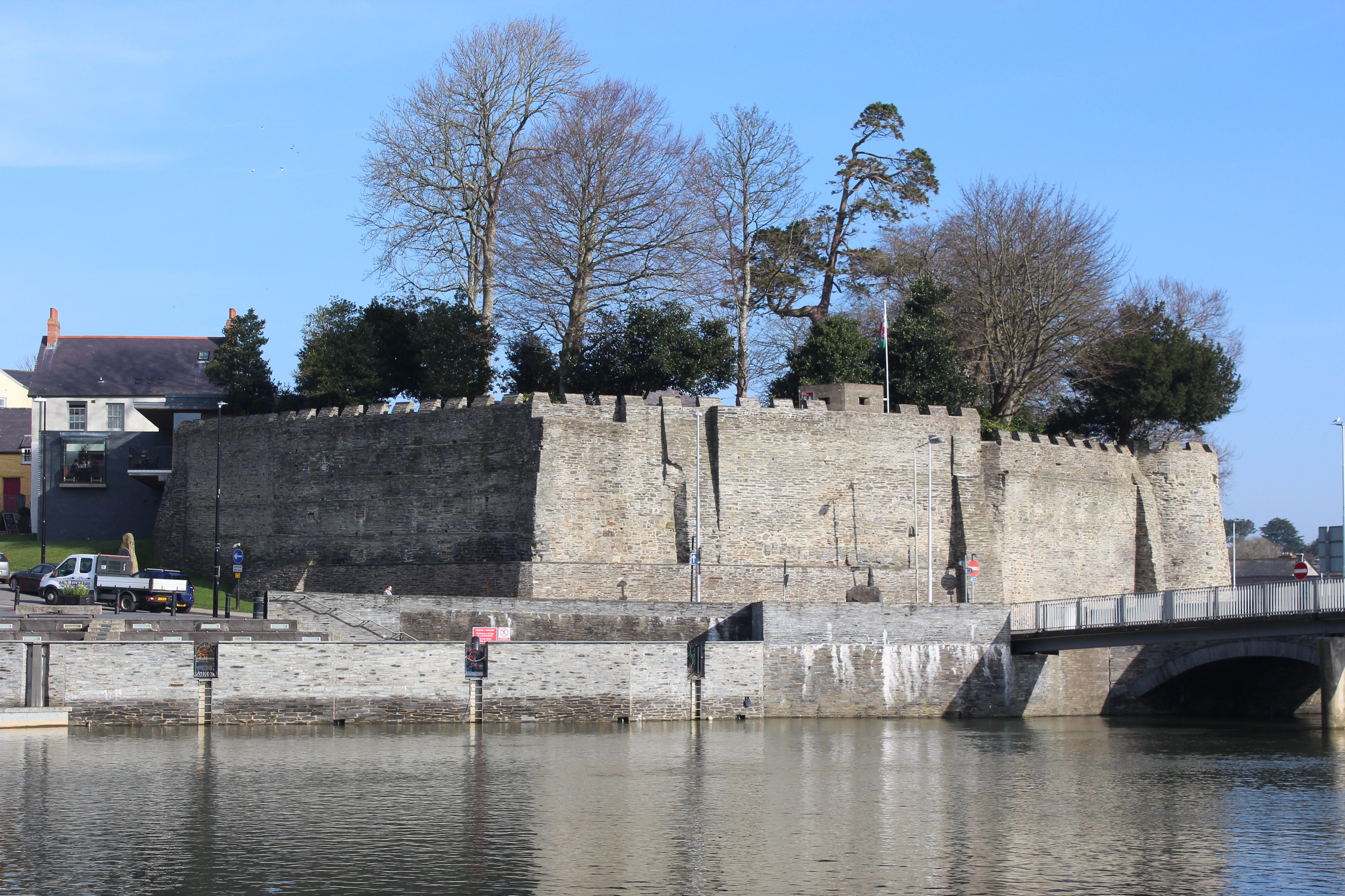
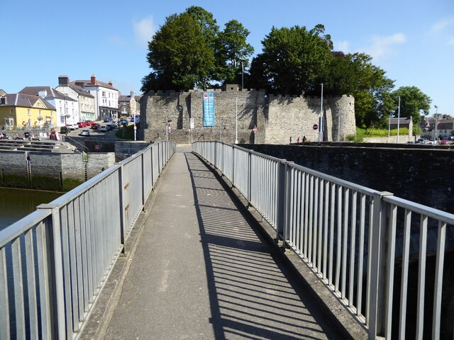
Cardigan Castle

Cardigan Castle (Welsh: Castell Aberteifi) is a castle overlooking the River Teifi in Cardigan, Ceredigion, Wales. It is a Grade I listed building. The...

Cardigan County School

Cardigan County School is the name given to the endowed grammar school in Cardigan which was founded there in the mid seventeenth century. The Intermediate...

Cardigan, Ceredigion

Cardigan (Welsh: Aberteifi, pronounced [abɛrˈtəivɪ] ) is both a town and a community in the county of Ceredigion, Wales. Positioned on the tidal reach...

Nearby Amenities

Located within 500m of 52.081695,-4.6867064
St Dogmaels
Is In: Ceredigion, Wales, UK
Name Cy: Llandudoch
Name En: St Dogmaels
Place: village
Population: 1117
Population Date: 2011
Source: npe
Source Population: Census
Wikidata: Q3405138
Lat/Long: 52.0818715/-4.6803483
Bus Stop
Bus: yes
Lit: no
Public Transport: platform
Shelter: yes
Lat/Long: 52.083599/-4.6831756
Post Box
Collection Times: Mo-Fr 09:00; Sa 07:00
Drive Through: no
Note: Listed as 586 not 576 on osm.mathmos.net/postboxes but definitely 576 (photo). Info plate on postbox dated 2023-03-08.
Operator: Royal Mail
Post Box Type: lamp
Ref: SA43 576D
Royal Cypher: EIIR
Royal Cypher Wikidata: Q33102113
Source: survey
Survey Date: 2023-06-20
Lat/Long: 52.0826643/-4.683021
Telephone
Booth: KX100
Covered: booth
Fee: yes
Note: Notices outside and inside booth say coins are not accepted. I couldn't figure out what is accepted.
Operator: BT
Payment Coins: no
Phone: +44 1239 612466
Lat/Long: 52.0819592/-4.6826805
Description: English translation is (approximately) "St Dogmaels is a notable place." Taken from a poem written in strict alliterative style (which has strong rules on the repetition of consonants) by Siôn Mawddwy.
Fixme: Attached to wall which has yet to be mapped.
Historic: memorial
Inscription: Llandudoch lle nodedig (SIÔN MAWDDWY C1601)
Material: slate
Memorial: plaque
Wikimedia Commons: File:Llandudoch lle nodedig.jpg
Lat/Long: 52.0818961/-4.6826551
Post Box
Collection Times: Mo-Fr 16:15; Sa 12:30
Drive Through: no
Operator: Royal Mail
Post Box Type: lamp
Ref: SA43 50
Royal Cypher: EIIR
Royal Cypher Wikidata: Q33102113
Lat/Long: 52.0816916/-4.6801157
Access: private
Door: yes
Entrance: yes
Lat/Long: 52.0816147/-4.6829622
Vending Machine
Check Date: 2022-08-02
Operator: Pembrokeshire County Council
Vending: parking_tickets
Lat/Long: 52.0821417/-4.679877
Information: guidepost
Tourism: information
Lat/Long: 52.0819033/-4.6826493
Bench
Backrest: no
Lat/Long: 52.081928/-4.6825763
Bench
Backrest: no
Lat/Long: 52.0819417/-4.6825979
Waste Basket
Lat/Long: 52.0819041/-4.6825967
Grit Bin
Lat/Long: 52.0819055/-4.682618
Post Box
Drive Through: no
Operator: Royal Mail
Post Box Type: wall
Lat/Long: 52.0804136/-4.6843882
Information: guidepost
Tourism: information
Lat/Long: 52.0803306/-4.6843533
Bench
Backrest: yes
Lat/Long: 52.0803414/-4.6843491
Direction: ENE
Generator Method: photovoltaic
Generator Output Electricity: yes
Generator Solar Modules: 14
Generator Source: solar
Generator Type: solar_photovoltaic_panel
Location: roof
Power: generator
Lat/Long: 52.08271/-4.6809117
Direction: WSW
Generator Method: photovoltaic
Generator Output Electricity: yes
Generator Solar Modules: 6
Generator Source: solar
Generator Type: solar_photovoltaic_panel
Location: roof
Power: generator
Lat/Long: 52.0798101/-4.6831799
Direction: WSW
Generator Method: photovoltaic
Generator Output Electricity: yes
Generator Solar Modules: 6
Generator Source: solar
Generator Type: solar_photovoltaic_panel
Location: roof
Power: generator
Lat/Long: 52.0797714/-4.683153
Direction: 170
Generator Method: photovoltaic
Generator Output Electricity: yes
Generator Solar Modules: 12
Generator Source: solar
Generator Type: solar_photovoltaic_panel
Location: roof
Power: generator
Lat/Long: 52.0783834/-4.6866828
Direction: 145
Generator Method: photovoltaic
Generator Output Electricity: yes
Generator Solar Modules: 3
Generator Source: solar
Generator Type: solar_photovoltaic_panel
Location: roof
Power: generator
Lat/Long: 52.0791549/-4.6859345
Direction: 145
Generator Method: photovoltaic
Generator Output Electricity: yes
Generator Solar Modules: 7
Generator Source: solar
Generator Type: solar_photovoltaic_panel
Location: roof
Power: generator
Lat/Long: 52.0791155/-4.6860072
Direction: 255
Generator Method: photovoltaic
Generator Output Electricity: yes
Generator Solar Modules: 12
Generator Source: solar
Generator Type: solar_photovoltaic_panel
Location: roof
Power: generator
Lat/Long: 52.0817659/-4.6851969
Direction: 260
Generator Method: photovoltaic
Generator Output Electricity: yes
Generator Solar Modules: 16
Generator Source: solar
Generator Type: solar_photovoltaic_panel
Location: roof
Power: generator
Lat/Long: 52.0838889/-4.6834803
Direction: 85
Generator Method: photovoltaic
Generator Output Electricity: yes
Generator Solar Modules: 8
Generator Source: solar
Generator Type: solar_photovoltaic_panel
Location: roof
Power: generator
Lat/Long: 52.0829197/-4.6827883
Direction: 265
Generator Method: photovoltaic
Generator Output Electricity: yes
Generator Solar Modules: 8
Generator Source: solar
Generator Type: solar_photovoltaic_panel
Location: roof
Power: generator
Lat/Long: 52.0829148/-4.6828553
Direction: 145
Generator Method: photovoltaic
Generator Output Electricity: yes
Generator Solar Modules: 6
Generator Source: solar
Generator Type: solar_photovoltaic_panel
Location: roof
Power: generator
Lat/Long: 52.0831799/-4.681077
Direction: 145
Generator Method: photovoltaic
Generator Output Electricity: yes
Generator Solar Modules: 10
Generator Source: solar
Generator Type: solar_photovoltaic_panel
Location: roof
Power: generator
Lat/Long: 52.0832411/-4.6812326
Direction: WSW
Generator Method: photovoltaic
Generator Output Electricity: yes
Generator Solar Modules: 12
Generator Source: solar
Generator Type: solar_photovoltaic_panel
Location: roof
Power: generator
Lat/Long: 52.0833178/-4.6818267
Direction: WSW
Generator Method: photovoltaic
Generator Output Electricity: yes
Generator Solar Modules: 16
Generator Source: solar
Generator Type: solar_photovoltaic_panel
Location: roof
Power: generator
Lat/Long: 52.0838528/-4.681758
Direction: 265
Generator Method: photovoltaic
Generator Output Electricity: yes
Generator Solar Modules: 6
Generator Source: solar
Generator Type: solar_photovoltaic_panel
Location: roof
Power: generator
Lat/Long: 52.0814445/-4.6812996
Leisure: picnic_table
Lat/Long: 52.0837441/-4.6805797
Leisure: picnic_table
Lat/Long: 52.0837223/-4.680539
The data included in this document is from www.openstreetmap.org. The data is made available under ODbL.

Have you been to Albro Castle?

Leave your review of Albro Castle below (or comments, questions and feedback).