Pinog
Coastal Marsh, Saltings in Pembrokeshire
Wales
Pinog
Pinog, located in Pembrokeshire, is a coastal marsh area renowned for its rich ecosystem and unique natural beauty. Situated near the village of Dale, this marshland is characterized by its extensive saltings, which are areas of salt marshes or tidal flats.
The marshes of Pinog are formed by the convergence of freshwater streams and the tidal waters of the Milford Haven Waterway. This creates a diverse environment where the saltwater meets the freshwater, resulting in an intricate network of channels, mudflats, and salt pans. The area is also home to a wide range of plant and animal species, making it an important site for conservation and biodiversity.
The salt marsh vegetation found in Pinog includes species such as samphire, cordgrass, and sea lavender, which thrive in the brackish water conditions. These plants provide nesting habitats and food sources for numerous bird species, including wading birds like herons, curlews, and oystercatchers.
Pinog is also a haven for birdwatchers, attracting enthusiasts throughout the year. With its strategic location along migratory routes, the marshes serve as temporary homes for various species of waterfowl and waders during their journeys.
In addition to its ecological significance, Pinog offers visitors a chance to witness stunning panoramic views of the surrounding landscape. The marshland is easily accessible via footpaths and offers opportunities for leisurely walks and bird-watching expeditions. Its tranquil atmosphere and untouched beauty make it a popular destination for nature lovers seeking a peaceful retreat.
Overall, Pinog, Pembrokeshire, with its coastal marshes and saltings, stands as a testament to the diverse and unique natural wonders that can be found in this region of Wales.
If you have any feedback on the listing, please let us know in the comments section below.
Pinog Images
Images are sourced within 2km of 52.082499/-4.6782593 or Grid Reference SN1646. Thanks to Geograph Open Source API. All images are credited.
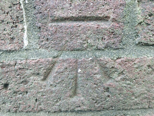
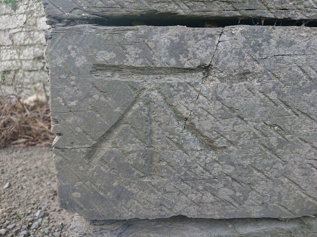
![OSBM Flush Bracket S0557 - Cardigan, St. Mary's School Ordnance Survey Benchmark (OSBM) used for levelling height above Ordnance Datum (OD).
Height (1954): 7.3333m OD (Newlyn). Mark verified by the Ordnance Survey in 1973. Description: FL BR S0557 S FACE 4.3M SW ANG SCH N SIDE RD. 1st Order BM.
The bracket was used on the Aberaeron to Carmarthen secondary line of the Second Geodetic Levelling of England &amp; Wales in 1927-1928. It was levelled with a height of 24.282&#039; above OD (Newlyn). Description: S face, 10&#039; from SW angle of school, N side of Pont-y-Cleifion, Cardigan. Abstract A 471: <span class="nowrap"><a title="http://discovery.nationalarchives.gov.uk/details/r/C11178815" rel="nofollow ugc noopener" href="http://discovery.nationalarchives.gov.uk/details/r/C11178815">Link</a><img style="margin-left:2px;" alt="External link" title="External link - shift click to open in new window" src="https://s1.geograph.org.uk/img/external.png" width="10" height="10"/></span> [OS 54/136].
The bracket was used on the Aberayron to Carmarthen secondary line of the Second Geodetic Levelling of England &amp; Wales in 1953-1954. It was levelled with a height of 24.117&#039; above OD (Newlyn). Abstract S 7: <span class="nowrap"><a title="http://discovery.nationalarchives.gov.uk/details/r/C11225155" rel="nofollow ugc noopener" href="http://discovery.nationalarchives.gov.uk/details/r/C11225155">Link</a><img style="margin-left:2px;" alt="External link" title="External link - shift click to open in new window" src="https://s1.geograph.org.uk/img/external.png" width="10" height="10"/></span> [OS 54/639].
The bracket was used on the Haverford West to Cardigan line (G077) of the Third Geodetic Levelling of England &amp; Wales in 1954. Abstract G 65: <span class="nowrap"><a title="http://discovery.nationalarchives.gov.uk/SearchUI/details?Uri=C11264473" rel="nofollow ugc noopener" href="http://discovery.nationalarchives.gov.uk/SearchUI/details?Uri=C11264473">Link</a><img style="margin-left:2px;" alt="External link" title="External link - shift click to open in new window" src="https://s1.geograph.org.uk/img/external.png" width="10" height="10"/></span> [OS 54/754].
Context: <a href="https://www.geograph.org.uk/photo/7106896">SN1846 : OSBM Flush Bracket S0557 - Cardigan, St. Mary's School</a>](https://s0.geograph.org.uk/geophotos/07/10/68/7106892_78427bcb.jpg)
![OSBM Flush Bracket S0557 - Cardigan, St. Mary's School Ordnance Survey Benchmark (OSBM) used for levelling height above Ordnance Datum (OD).
Height (1954): 7.3333m OD (Newlyn). Mark verified by the Ordnance Survey in 1973. Description: FL BR S0557 S FACE 4.3M SW ANG SCH N SIDE RD. 1st Order BM.
The bracket was used on the Aberaeron to Carmarthen secondary line of the Second Geodetic Levelling of England &amp; Wales in 1927-1928. It was levelled with a height of 24.282&#039; above OD (Newlyn). Description: S face, 10&#039; from SW angle of school, N side of Pont-y-Cleifion, Cardigan. Abstract A 471: <span class="nowrap"><a title="http://discovery.nationalarchives.gov.uk/details/r/C11178815" rel="nofollow ugc noopener" href="http://discovery.nationalarchives.gov.uk/details/r/C11178815">Link</a><img style="margin-left:2px;" alt="External link" title="External link - shift click to open in new window" src="https://s1.geograph.org.uk/img/external.png" width="10" height="10"/></span> [OS 54/136].
The bracket was used on the Aberayron to Carmarthen secondary line of the Second Geodetic Levelling of England &amp; Wales in 1953-1954. It was levelled with a height of 24.117&#039; above OD (Newlyn). Abstract S 7: <span class="nowrap"><a title="http://discovery.nationalarchives.gov.uk/details/r/C11225155" rel="nofollow ugc noopener" href="http://discovery.nationalarchives.gov.uk/details/r/C11225155">Link</a><img style="margin-left:2px;" alt="External link" title="External link - shift click to open in new window" src="https://s1.geograph.org.uk/img/external.png" width="10" height="10"/></span> [OS 54/639].
The bracket was used on the Haverford West to Cardigan line (G077) of the Third Geodetic Levelling of England &amp; Wales in 1954. Abstract G 65: <span class="nowrap"><a title="http://discovery.nationalarchives.gov.uk/SearchUI/details?Uri=C11264473" rel="nofollow ugc noopener" href="http://discovery.nationalarchives.gov.uk/SearchUI/details?Uri=C11264473">Link</a><img style="margin-left:2px;" alt="External link" title="External link - shift click to open in new window" src="https://s1.geograph.org.uk/img/external.png" width="10" height="10"/></span> [OS 54/754].
Close-up: <a href="https://www.geograph.org.uk/photo/7106892">SN1846 : OSBM Flush Bracket S0557 - Cardigan, St. Mary's School</a>](https://s0.geograph.org.uk/geophotos/07/10/68/7106896_ba61c266.jpg)
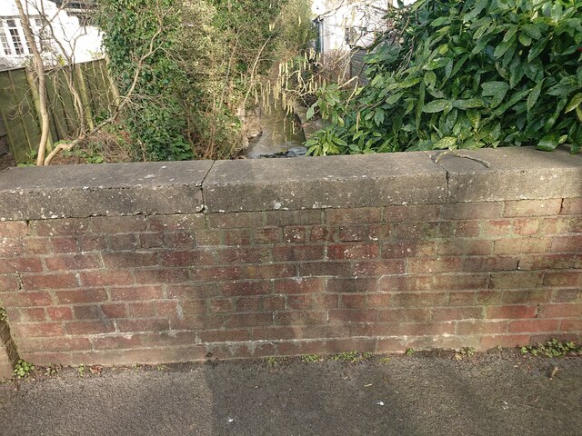
![Site of bridge, Grange Town, Cardigan There used to be a bridge at this location, over a small stream from the common, opposite. The drainage of the area was probably re-organised when the common was converted from allotments to King George’s Field c.1920. The bridge bore an Ordnance Survey benchmark:
The mark was used on the Warrington to Pembroke Docks line of the First Primary Levelling of England &amp; Wales in 1851-1852. It was levelled with a height of 75.663&#039; above OD (Liverpool). Description: 745. Mark on East battlement of small bridge ; 1.72 ft. below top of battlement. Page 536 of the abstract: <span class="nowrap"><a title="https://www.bench-marks.org.uk/abstract/ew1gl/1GLA_536.png" rel="nofollow ugc noopener" href="https://www.bench-marks.org.uk/abstract/ew1gl/1GLA_536.png">Link</a><img style="margin-left:2px;" alt="External link" title="External link - shift click to open in new window" src="https://s1.geograph.org.uk/img/external.png" width="10" height="10"/></span>
A mark at this location was used on the Aberaeron to Carmarthen secondary line of the Second Geodetic Levelling of England &amp; Wales in 1927-1928. Its height of 77.50&#039; above OD (Newlyn) suggests the original mark was replaced by a pivot on top of the parapet. Abstract A 471: <span class="nowrap"><a title="http://discovery.nationalarchives.gov.uk/details/r/C11178815" rel="nofollow ugc noopener" href="http://discovery.nationalarchives.gov.uk/details/r/C11178815">Link</a><img style="margin-left:2px;" alt="External link" title="External link - shift click to open in new window" src="https://s1.geograph.org.uk/img/external.png" width="10" height="10"/></span> [OS 54/136].](https://s3.geograph.org.uk/geophotos/07/10/70/7107051_75cf3c61.jpg)
![Castle Street, Cardigan There used to be a roadside house at this location which bore an Ordnance Survey benchmark.
The mark was used on the Warrington to Pembroke Docks line of the First Primary Levelling of England &amp; Wales in 1851-1852. It was levelled with a height of 56.910&#039; above OD (Liverpool). Description: 749. Mark on corner of James Thomas&#039;s house ; 2.75 ft. above surface. Page 536 of the abstract: <span class="nowrap"><a title="https://www.bench-marks.org.uk/abstract/ew1gl/1GLA_536.png" rel="nofollow ugc noopener" href="https://www.bench-marks.org.uk/abstract/ew1gl/1GLA_536.png">Link</a><img style="margin-left:2px;" alt="External link" title="External link - shift click to open in new window" src="https://s1.geograph.org.uk/img/external.png" width="10" height="10"/></span>
The mark was included on the Aberaeron to Carmarthen secondary line of the Second Geodetic Levelling of England &amp; Wales in 1927-1928. It was levelled with a height of 57.08&#039; above OD (Newlyn). Abstract A 471: <span class="nowrap"><a title="http://discovery.nationalarchives.gov.uk/details/r/C11178815" rel="nofollow ugc noopener" href="http://discovery.nationalarchives.gov.uk/details/r/C11178815">Link</a><img style="margin-left:2px;" alt="External link" title="External link - shift click to open in new window" src="https://s1.geograph.org.uk/img/external.png" width="10" height="10"/></span> [OS 54/136].](https://s0.geograph.org.uk/geophotos/07/10/82/7108200_793803eb.jpg)
![Tenby Road, Cardigan There used to be a roadside house at this junction which bore an Ordnance Survey benchmark.
The mark was used on the Warrington to Pembroke Docks line of the First Primary Levelling of England &amp; Wales in 1851-1852. It was levelled with a height of 84.146&#039; above OD (Liverpool). Description: 750. Mark on corner of small house, at junction of road to Narberth ; 2.33 ft. above surface. Page 536 of the abstract: <span class="nowrap"><a title="https://www.bench-marks.org.uk/abstract/ew1gl/1GLA_536.png" rel="nofollow ugc noopener" href="https://www.bench-marks.org.uk/abstract/ew1gl/1GLA_536.png">Link</a><img style="margin-left:2px;" alt="External link" title="External link - shift click to open in new window" src="https://s1.geograph.org.uk/img/external.png" width="10" height="10"/></span>
The mark was included on the Aberaeron to Carmarthen secondary line of the Second Geodetic Levelling of England &amp; Wales in 1927-1928. It was levelled with a height of 84.33&#039; above OD (Newlyn). Abstract A 471: <span class="nowrap"><a title="http://discovery.nationalarchives.gov.uk/details/r/C11178815" rel="nofollow ugc noopener" href="http://discovery.nationalarchives.gov.uk/details/r/C11178815">Link</a><img style="margin-left:2px;" alt="External link" title="External link - shift click to open in new window" src="https://s1.geograph.org.uk/img/external.png" width="10" height="10"/></span> [OS 54/136].](https://s3.geograph.org.uk/geophotos/07/10/82/7108219_3c1a2942.jpg)


Pinog is located at Grid Ref: SN1646 (Lat: 52.082499, Lng: -4.6782593)
Unitary Authority: Pembrokeshire
Police Authority: Dyfed Powys
What 3 Words
///denoting.joins.station. Near Cardigan, Ceredigion
Nearby Locations
Related Wikis
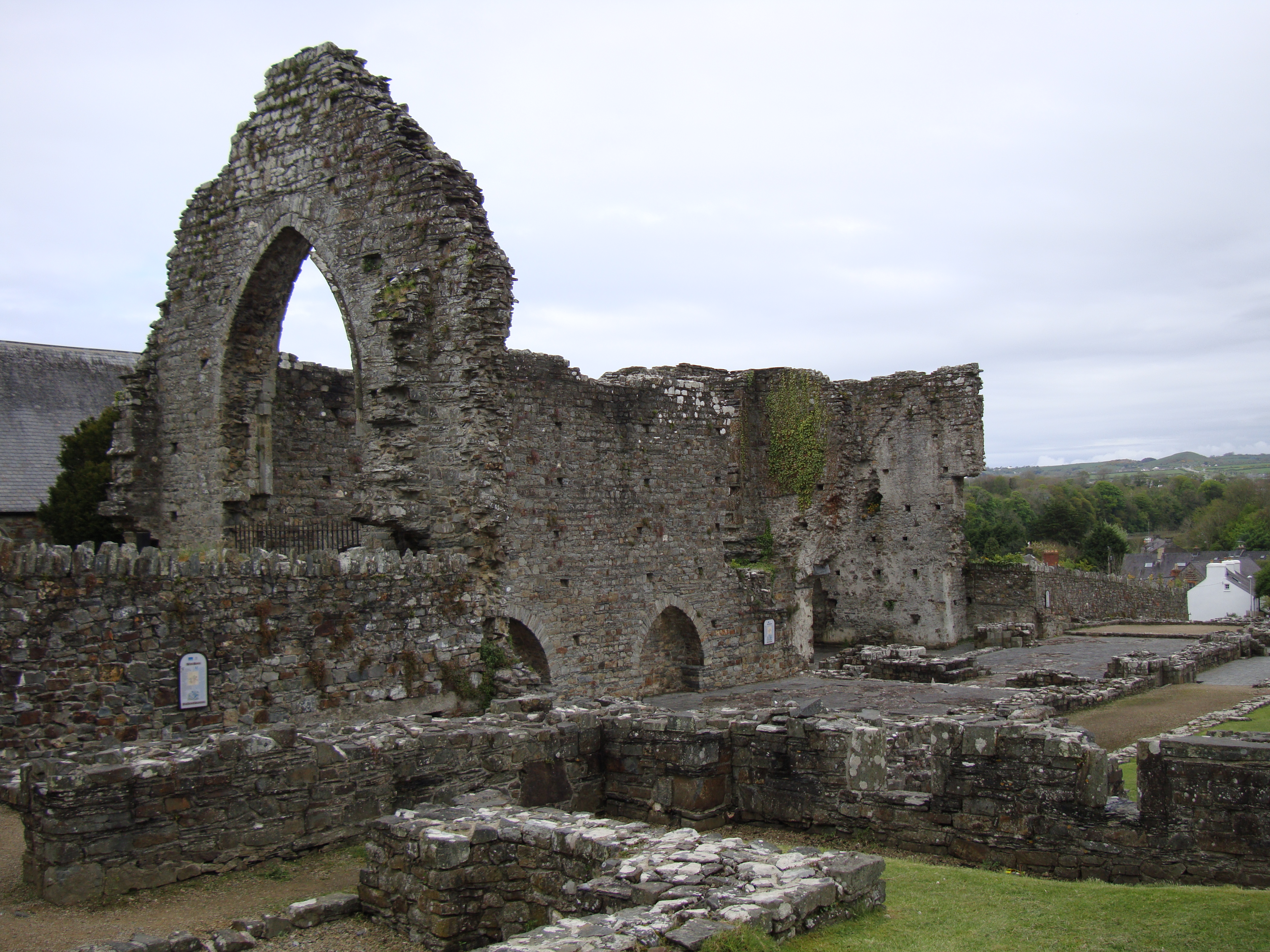
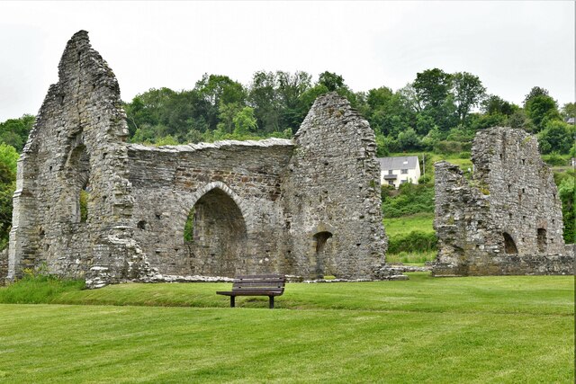
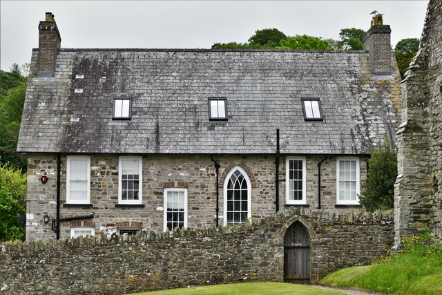
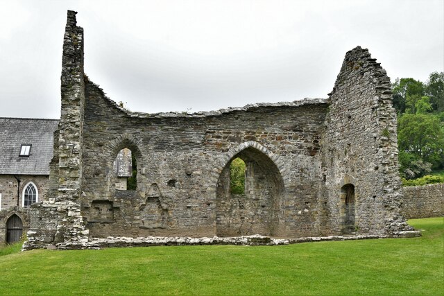
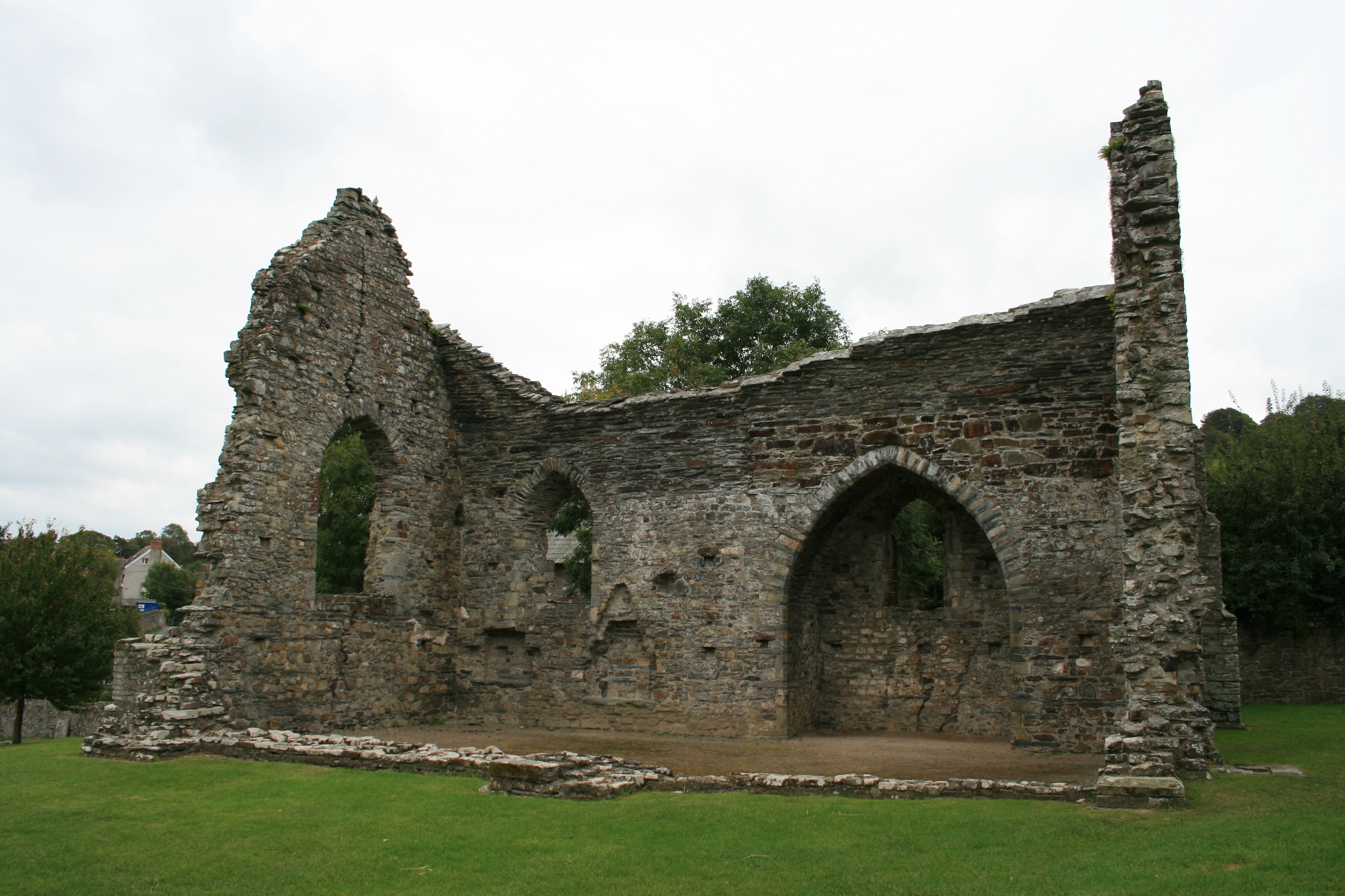
Abbey of St Mary, St Dogmaels
The Abbey of St Mary (also known as St Dogmaels Abbey) is Grade I listed ruined abbey in St Dogmaels in Pembrokeshire, Wales, on the banks of the River...
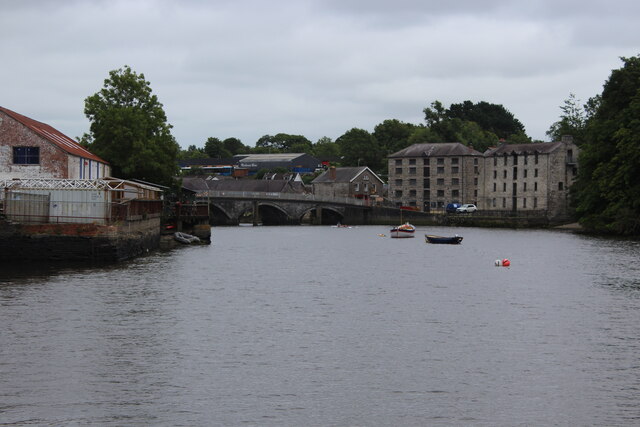
St Dogmaels
St Dogmaels (Welsh: Llandudoch) is a village, parish and community in Pembrokeshire, Wales, on the estuary of the River Teifi, a mile downstream from the...

St Dogmaels television relay station
The St Dogmaels television relay station is a broadcasting and telecommunications facility located just above the village of St Dogmaels in Pembrokeshire...
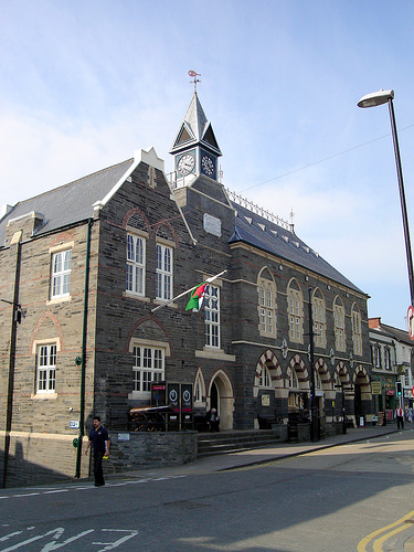
Cardigan Guildhall
Cardigan Guildhall (Welsh: Neuadd y Dref Aberteifi), is a municipal building in Pendre, Cardigan, Ceredigion, Wales. The structure, which is now used as...
Nearby Amenities
Located within 500m of 52.082499,-4.6782593Have you been to Pinog?
Leave your review of Pinog below (or comments, questions and feedback).