Waltham

Settlement in Lincolnshire

England

Waltham

High Street, Waltham – 1978 The view is surprisingly little changed in 2021, although with more tree growth.

The bus is no.90 of Grimsby-Cleethorpes Transport, an undertaking jointly owned by the Boroughs of Grimsby and Cleethorpes, which had merged their separate undertakings in 1957. It is a Daimler Fleetline with Roe bodywork, new in 1970.

This is one of a series of views featuring buses in the 60s, 70s, and 80s. <a title="https://www.geograph.org.uk/search.php?i=137652761" href="https://www.geograph.org.uk/search.php?i=137652761">Link</a>
High Street, Waltham – 1978 Credit: Alan Murray-Rust

The requested URL returned error: 429 Too Many Requests

If you have any feedback on the listing, please let us know in the comments section below.

Waltham Images

Images are sourced within 2km of 53.516712/-0.099723059 or Grid Reference TA2603. Thanks to Geograph Open Source API. All images are credited.

High Street, Waltham – 1978 The view is surprisingly little changed in 2021, although with more tree growth.

The bus is no.90 of Grimsby-Cleethorpes Transport, an undertaking jointly owned by the Boroughs of Grimsby and Cleethorpes, which had merged their separate undertakings in 1957. It is a Daimler Fleetline with Roe bodywork, new in 1970.

This is one of a series of views featuring buses in the 60s, 70s, and 80s. <a title="https://www.geograph.org.uk/search.php?i=137652761" href="https://www.geograph.org.uk/search.php?i=137652761">Link</a>
High Street, Waltham – 1978
The view is surprisingly little changed in 2021, although with more tree growth. The bus is no.90 of Grimsby-Cleethorpes Transport, an undertaking jointly owned by the Boroughs of Grimsby and Cleethorpes, which had merged their separate undertakings in 1957. It is a Daimler Fleetline with Roe bodywork, new in 1970. This is one of a series of views featuring buses in the 60s, 70s, and 80s. Link
New development by Tollbar Roundabout, A16, Grimsby: aerial 2023
All Saints, Waltham In origin early 14th century.
All Saints, Waltham
In origin early 14th century.
Scartho Sanatorium Former sanatorium undergoing re-development
Scartho Sanatorium
Former sanatorium undergoing re-development
Waltham Fire Station Manned by retained firefighters
Waltham Fire Station
Manned by retained firefighters
Waltham Windmill Six sail tower mill of 1879 and still workable.
Waltham Windmill
Six sail tower mill of 1879 and still workable.
Waltham
Waltham
Grange Farm, Barnoldby-Le-Beck
Porters Garage, Waltham
A Basic Village Hall At Brigsley.
A Basic Village Hall
At Brigsley.
The Road To Holton le Clay From Waltham.
The Road To Holton le Clay
From Waltham.
The Road To Waltham From Holton le Clay.
The Road To Waltham
From Holton le Clay.
The A16 Near New Waltham, between Grimsby and Louth.
The A16
Near New Waltham, between Grimsby and Louth.
Through The Wood To Scartho A Public Bridleway from the road between Waltham and Bradley.
Through The Wood To Scartho
A Public Bridleway from the road between Waltham and Bradley.
Lighting-Up Time On the road to Bradley from Waltham.
Lighting-Up Time
On the road to Bradley from Waltham.
Croxby Avenue In Scartho, a suburb of Grimsby.
Croxby Avenue
In Scartho, a suburb of Grimsby.
School's Out The A16 as school ends for the day - and not a single cyclist is riding legally!
School's Out
The A16 as school ends for the day - and not a single cyclist is riding legally!
The Hawthorne Motor Company On the A16 at New Waltham.
The Hawthorne Motor Company
On the A16 at New Waltham.
Show me another place!

Waltham is located at Grid Ref: TA2603 (Lat: 53.516712, Lng: -0.099723059)

Division: Parts of Lindsey

Unitary Authority: North East Lincolnshire

Police Authority: Humberside

What 3 Words

///yard.salt.canny. Near Waltham, Lincolnshire

Related Wikis

Waltham, Lincolnshire

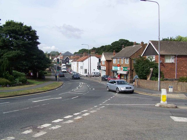
Waltham is a village and civil parish in North East Lincolnshire, England. It is 4 miles (6 km) south of Grimsby close to the suburb of Scartho and to...
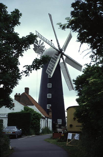
Waltham Windmill

Waltham Windmill is a six-sailed windmill located in the village of Waltham, five miles from Grimsby in North East Lincolnshire, England. It is renowned...

Barnoldby le Beck

Barnoldby le Beck is a village and civil parish in North East Lincolnshire, England, It is situated just east of the A18 and is close to the village of...

Waltham Toll Bar Academy

Waltham Toll Bar Academy is a co-educational secondary school and sixth form, in New Waltham, North East Lincolnshire, England. == Admissions == A secondary...

Nearby Amenities

Located within 500m of 53.516712,-0.099723059
Waltham
Is In: Lincolnshire, England, UK
Is In District: North East Lincolnshire
Place: village
Lat/Long: 53.515849/-0.0963777
Mini Roundabout
Direction: clockwise
Lat/Long: 53.5157744/-0.1030713
Bus Stop
Ross Hall
Naptan AtcoCode: 2280000188
Naptan Bearing: E
Naptan CommonName: Ross Hall
Naptan Indicator: opp
Naptan Landmark: Ross Hall
Naptan NaptanCode: grimtaw
Naptan Notes: none
Naptan PlusbusZoneRef: GRMSBYT
Naptan Street: Barnoldby Road
Naptan Verified: no
Source: naptan_import
Lat/Long: 53.5156268/-0.1049449
Bus Stop
Ross Hall
Naptan AtcoCode: 2280000189
Naptan Bearing: W
Naptan CommonName: Ross Hall
Naptan Indicator: adj
Naptan Landmark: Ross Hall
Naptan NaptanCode: grimwaw
Naptan Notes: none
Naptan PlusbusZoneRef: GRMSBYT
Naptan Street: Barnoldby Road
Naptan Verified: no
Source: naptan_import
Lat/Long: 53.5156654/-0.1039778
Bus Stop
Telephone Exchange
Naptan AtcoCode: 22800005917
Naptan Bearing: N
Naptan CommonName: Telephone Exchange
Naptan Indicator: opp
Naptan Landmark: Telephone Exchange
Naptan NaptanCode: grimpdp
Naptan Notes: BW--2280065039
Naptan PlusbusZoneRef: GRMSBYT
Naptan Street: Grimsby Road
Naptan Verified: no
Source: naptan_import
Lat/Long: 53.51903/-0.0939471
Bus Stop
Brigsley Road
Naptan AtcoCode: 22800007210
Naptan Bearing: S
Naptan CommonName: Brigsley Road
Naptan Crossing: Cheapside
Naptan Indicator: o/s 6
Naptan NaptanCode: griawdw
Naptan Notes: BW--2280065040
Naptan PlusbusZoneRef: GRMSBYT
Naptan Street: Brigsley Road
Naptan Verified: no
Source: naptan_import
Lat/Long: 53.5151628/-0.1028992
Bus Stop
The Kings Head
Naptan AtcoCode: 22800064311
Naptan Bearing: SW
Naptan CommonName: The Kings Head
Naptan Indicator: o/s
Naptan Landmark: The Kings Head
Naptan NaptanCode: griadgj
Naptan Notes: none
Naptan PlusbusZoneRef: GRMSBYT
Naptan Street: High Street
Naptan Verified: no
Source: naptan_import
Lat/Long: 53.5164156/-0.1019683
Bus Stop
Church Lane
Naptan AtcoCode: 22800064313
Naptan Bearing: NE
Naptan CommonName: Church Lane
Naptan Crossing: Church Lane
Naptan Indicator: opp
Naptan NaptanCode: griajgj
Naptan Notes: none
Naptan PlusbusZoneRef: GRMSBYT
Naptan Street: High Street
Naptan Verified: no
Source: naptan_import
Lat/Long: 53.5170988/-0.0980009
Bus Stop
Church Lane
Naptan AtcoCode: 22800064314
Naptan Bearing: SW
Naptan CommonName: Church Lane
Naptan Crossing: Church Lane
Naptan Indicator: adj
Naptan NaptanCode: griamgj
Naptan Notes: none
Naptan PlusbusZoneRef: GRMSBYT
Naptan Street: High Street
Naptan Verified: no
Source: naptan_import
Lat/Long: 53.5170563/-0.0975955
Bus Stop
Ings Lane
Naptan AtcoCode: 22800064315
Naptan Bearing: NE
Naptan CommonName: Ings Lane
Naptan Crossing: Ings Lane
Naptan Indicator: opp
Naptan NaptanCode: griapgj
Naptan Notes: none
Naptan PlusbusZoneRef: GRMSBYT
Naptan Street: High Street
Naptan Verified: no
Source: naptan_import
Lat/Long: 53.5175558/-0.0962155
Bus Stop
Ings Lane
Naptan AtcoCode: 22800064316
Naptan Bearing: SW
Naptan CommonName: Ings Lane
Naptan Crossing: Ings Lane
Naptan Indicator: adj
Naptan NaptanCode: griatgj
Naptan Notes: none
Naptan PlusbusZoneRef: GRMSBYT
Naptan Street: High Street
Naptan Verified: no
Source: naptan_import
Lat/Long: 53.5176565/-0.0952004
Bus Stop
Kirkgate
Naptan AtcoCode: 22800064412
Naptan Bearing: NE
Naptan CommonName: Kirkgate
Naptan Crossing: Kirkside
Naptan Indicator: o/s 16
Naptan NaptanCode: griawgj
Naptan Notes: none
Naptan PlusbusZoneRef: GRMSBYT
Naptan Street: Kirkgate
Naptan Verified: no
Source: naptan_import
Lat/Long: 53.5160267/-0.1006885
Telephone Exchange
Naptan AtcoCode: 2280065039
Naptan Bearing: S
Naptan BusStopType: CUS
Naptan CommonName: Telephone Exchange
Naptan Indicator: adj
Naptan Landmark: Telephone Exchange
Naptan NaptanCode: griadgp
Naptan Notes: 22800005917--CUS
Naptan PlusbusZoneRef: GRMSBYT
Naptan Street: Grimsby Road
Naptan Verified: no
Source: naptan_import
Lat/Long: 53.5190531/-0.0937047
Bus Stop
Brigsley Road
Naptan AtcoCode: 2280065040
Naptan Bearing: N
Naptan BusStopType: CUS
Naptan CommonName: Brigsley Road
Naptan Crossing: Cheapside
Naptan Indicator: opp 6
Naptan NaptanCode: griajgp
Naptan Notes: 22800007210--CUS
Naptan PlusbusZoneRef: GRMSBYT
Naptan Street: Brigsley Road
Naptan Verified: no
Source: naptan_import
Lat/Long: 53.5151934/-0.1031241
Bus Stop
Cheapside
Naptan AtcoCode: 2280065046
Naptan Bearing: SE
Naptan CommonName: Cheapside
Naptan Crossing: High Street
Naptan Indicator: o/s 7
Naptan NaptanCode: gridjgp
Naptan PlusbusZoneRef: GRMSBYT
Naptan Street: Cheapside
Naptan Verified: no
Source: naptan_import
Lat/Long: 53.515553/-0.1019918
Mini Roundabout
Direction: clockwise
Lat/Long: 53.5154468/-0.102963
Turning Circle
Source: Bing
Lat/Long: 53.5157549/-0.1065262
Post Box
Check Date: 2024-01-08
Collection Plate: CP1D
Collection Times: Mo-Fr 09:00; Sa 07:00
Image: https://i.postimg.cc/28yhYVcm/DN37-145-D.jpg
Location: High Street, outside No.43
Operator: Royal Mail
Operator Wikidata: Q638098
Post Box Design: type_a
Post Box Type: pillar
Ref: DN37 145D
Royal Cypher: EIIR
Royal Cypher Wikidata: Q33102113
Source: survey
Lat/Long: 53.5167997/-0.1014906
Turning Circle
Source: Bing
Lat/Long: 53.5200992/-0.1015933
Pub
Tilted Barrel
Addr City: Grimsby
Addr Housenumber: 2
Addr Postcode: DN37 0LS
Addr Street: Kirkgate
Addr Suburb: Waltham
Wifi: no
Lat/Long: 53.5163289/-0.1003165
Pub
Kings Head
Addr City: Grimsby
Addr Postcode: DN37 0LL
Addr Street: High Street
Addr Suburb: Waltham
Lat/Long: 53.5163011/-0.1015289
Bar
British Legion Club (Waltham)
Addr City: Grimsby
Addr Postcode: DN37 0JR
Addr Street: Barnoldby Road
Addr Suburb: Waltham
Lat/Long: 53.5153095/-0.10476
Bar
Waltham Tea Gardens
Addr City: Grimsby
Addr Housenumber: 38
Addr Postcode: DN37 0EU
Addr Street: Skinners Lane
Addr Suburb: Waltham
Lat/Long: 53.5149821/-0.0954503
Crossing
Bicycle: yes
Lat/Long: 53.5171116/-0.0983524
Crossing
Bicycle: yes
Lat/Long: 53.5169582/-0.0992099
Lincolnshire Co-op
Addr City: Grimsby
Addr Housenumber: 79-83
Addr Postcode: DN37 0LT
Addr Street: High Street
Addr Suburb: Waltham
Brand: Lincolnshire Co-op
Brand Wikidata: Q6551231
Opening Hours: Mo-Su 07:00-22:00
Operator: Lincolnshire Co-op
Shop: supermarket
Lat/Long: 53.5170094/-0.1000786
Restaurant
Mumbai Blues
Contact Facebook: https://www.facebook.com/MumbaiBluesIndian/
Cuisine: indian
Phone: +44 1472 822 779
Website: http://www.mumbaiblueswaltham.co.uk/
Lat/Long: 53.5171254/-0.1003421
Fast Food
Waltham Kebab House
Addr City: Grimsby
Addr Housenumber: 73
Addr Postcode: DN37 0LT
Addr Street: High Street
Addr Suburb: Waltham
Contact Facebook: https://www.facebook.com/Waltham-Kebab-House-118559091530800/
Cuisine: kebab
Phone: +44 1472 823 838
Lat/Long: 53.5171031/-0.1004313
Don Noble
Addr City: Grimsby
Addr Housenumber: 71
Addr Postcode: DN37 0LT
Addr Street: High Street
Addr Suburb: Waltham
Phone: +44 1472 826 111
Shop: bookmaker
Lat/Long: 53.5171167/-0.1005245
Fast Food
Yummy Oriental
Addr City: Grimsby
Addr Housenumber: 69
Addr Postcode: DN37 0LT
Addr Street: High Street
Addr Suburb: Waltham
Contact Facebook: https://www.facebook.com/Yummy-Oriental-Chinese-Takeaway-110606351416427/
Cuisine: chinese
Phone: +44 1472 822 181
Lat/Long: 53.5170967/-0.100609
Fast Food
The Frying Pan
Addr City: Grimsby
Addr Housenumber: 77
Addr Postcode: DN37 0LT
Addr Street: High Street
Addr Suburb: Waltham
Cuisine: fish_and_chips
Phone: +44 1472 823 002
Lat/Long: 53.5171178/-0.100259
Barrier: kissing_gate
Kissing Gate: triangular_profile
Source: survey
Lat/Long: 53.5145969/-0.0941887
Barrier: kissing_gate
Kissing Gate: triangular_profile
Source: survey
Lat/Long: 53.5154269/-0.0947886
Bicycle Parking
Waltham Library
Bicycle Parking: stands
Capacity: 6
Source: survey
Lat/Long: 53.51669/-0.1003924
Bicycle Parking
Waltham Shops
Bicycle Parking: stands
Capacity: 4
Source: survey
Lat/Long: 53.5170648/-0.1007143
Bench
Backrest: yes
Bench: yes
Colour: black
Seats: 4
Source: survey
Lat/Long: 53.5167299/-0.100835
Bench
Backrest: yes
Bench: yes
Colour: black
Seats: 4
Source: survey
Lat/Long: 53.516873/-0.0995602
Waste Basket
Check Date: 2022-03-28
Source: survey
Waste: trash
Lat/Long: 53.5174037/-0.096121
Waste Basket
Check Date: 2022-03-28
Source: survey
Waste: trash
Lat/Long: 53.5171362/-0.0982359
Bench
Bench: yes
Source: survey
Lat/Long: 53.5174265/-0.0961498
Waste Basket
Check Date: 2022-03-28
Source: survey
Waste: trash
Lat/Long: 53.5167302/-0.1008891
Spar
Addr City: Grimsby
Addr Housenumber: 3
Addr Postcode: DN37 0LP
Addr Street: Kirkgate
Addr Suburb: Waltham
Branch: Waltham
Brand: Spar
Brand Wikidata: Q610492
Phone: +44 1472 823 786
Shop: supermarket
Website: https://www.spar.co.uk/store-locator/afb49013-spar-kirkgate/
Lat/Long: 53.5162913/-0.0997406
Post Office
Waltham Post Office
Addr City: Grimsby
Addr Country: GB
Addr Housenumber: 3
Addr Postcode: DN37 0LP
Addr Street: Kirkgate
Brand: Post Office
Brand Wikidata: Q1783168
Check Date: 2022-05-27
Contact Website: https://www.postoffice.co.uk/branch-finder/5173116/waltham
Opening Hours: Mo-Su 07:00-22:00
Operator: Spar
Ref Pol Id: 127931
Lat/Long: 53.516328/-0.0998184
Bench
Backrest: yes
Bench: yes
Colour: brown
Seats: 4
Source: survey
Lat/Long: 53.5152012/-0.1028761
Waste Basket
Check Date: 2022-04-02
Source: survey
Waste: trash
Lat/Long: 53.5156463/-0.102569
Bench
Backrest: yes
Bench: yes
Colour: black
Seats: 4
Source: survey
Lat/Long: 53.5156143/-0.1024993
Historic: memorial
Memorial: war_memorial
Source: survey
Type: cross
Lat/Long: 53.5156175/-0.1028372
Bench
Backrest: yes
Bench: yes
Colour: black
Seats: 4
Source: survey
Lat/Long: 53.5156741/-0.1026535
Bend The Trend
Addr City: Grimsby
Addr Country: GB
Addr Housenumber: 39
Addr Postcode: DN37 0LJ
Addr Street: High Street
Addr Suburb: Waltham
Contact Facebook: https://www.facebook.com/groups/2196814837032973/
Opening Hours: Mo-Sa 10:00-16:00; Su closed
Shop: boutique
Lat/Long: 53.516655/-0.1018354
Beauty By Louise
Contact Facebook: https://www.facebook.com/people/Beauty-By-Louise/100047960207113/
Email: info@beautybylouise.com
Opening Hours: Mo-We 09:00-17:30; Th, Fr 09:00-19:00; Sa 09:00-15:00; Su closed
Phone: +44 1472 827 459
Shop: beauty
Website: http://www.beautybylouise.com/Home.html
Lat/Long: 53.5167491/-0.101696
The Boutique
Addr City: Grimsby
Addr Country: GB
Addr Housenumber: 43
Addr Postcode: DN37 0LJ
Addr Street: High Street
Addr Suburb: Waltham
Contact Facebook: https://www.facebook.com/theboutiquewaltham/
Contact Instagram: https://www.instagram.com/theboutiquewaltham/
Email: info@boutiquewaltham.co.uk
Opening Hours: Mo-Tu 10:00-16:00; We-Sa 10:00-17:00; Su closed
Phone: +44 1472 827 886
Shop: boutique
Website: https://www.boutiquewaltham.co.uk/
Lat/Long: 53.5168974/-0.1015417
Pharmacy
Cottingham Pharmacy
Addr City: Grimsby
Addr Country: GB
Addr Housenumber: 41
Addr Postcode: DN37 0LJ
Addr Street: High Street
Addr Suburb: Waltham
Email: pharmacist@walthampharmacy.com
Opening Hours: Mo-Fr 08:45-17:30; Sa 08:45-13:00; Su closed
Phone: +44 1472 826 427
Website: https://www.walthampharmacy.com/
Lat/Long: 53.5168615/-0.1016222
Post Box
Check Date: 2024-02-04
Collection Plate: CP7D
Collection Times: Mo-Fr 09:00; Sa 07:00
Image: https://i.postimg.cc/s2HVH0Vx/DN37-294-D.jpg
Location: Ings Lane
Operator: Royal Mail
Operator Wikidata: Q638098
Post Box Mounting: pier
Post Box Type: lamp
Ref: DN37 294D
Royal Cypher: EIIR
Royal Cypher Wikidata: Q33102113
Source: survey
Lat/Long: 53.5173818/-0.0958715
The data included in this document is from www.openstreetmap.org. The data is made available under ODbL.

Have you been to Waltham?

Leave your review of Waltham below (or comments, questions and feedback).