Bow

Settlement in Middlesex

England

Bow

River Lee Navigation, Hackney Wick Looking north from the bridge at White Post Lane.  On the left is the Crate Brewery - one of several beer and street food venues that have helped to transform this previously rundown canal backwater into a party hotspot.
River Lee Navigation, Hackney Wick Credit: Mark Percy

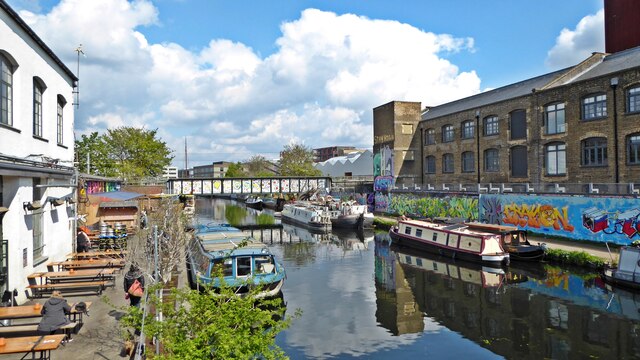
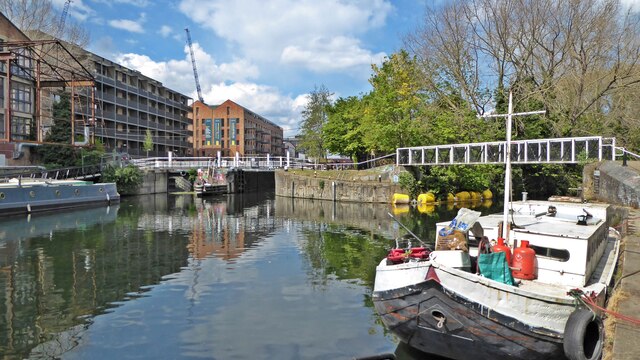
Bow is a district located in the borough of Tower Hamlets, in the East End of London, England. It is situated within the historic county of Middlesex, although it is now part of Greater London. Bow is bordered by the River Lea to the east, the Regent's Canal to the south, and Mile End Road to the north.

The area has a rich history, dating back to Roman times when it was a small hamlet known as Stratford-atte-Bow due to the presence of a bridge over the River Lea. In medieval times, Bow became a prosperous village, famous for its bow-shaped bridge and its association with the longbow archers of the Battle of Agincourt.

Today, Bow is a vibrant and diverse neighborhood with a mix of residential, commercial, and industrial areas. The district is known for its Victorian terraced houses, which line many of its streets. The area has seen significant redevelopment in recent years, with the creation of new housing developments and the restoration of historic buildings.

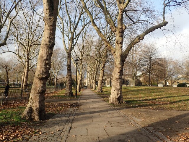
Bow is well-served by public transportation, with several underground and DLR (Docklands Light Railway) stations providing easy access to the rest of London. The district also benefits from a range of amenities, including shops, restaurants, parks, and leisure facilities.

Overall, Bow is a thriving and culturally diverse district with a rich heritage and a convenient location, making it an attractive place for residents and visitors alike.

If you have any feedback on the listing, please let us know in the comments section below.

Bow Images

Images are sourced within 2km of 51.530154/-0.027055 or Grid Reference TQ3683. Thanks to Geograph Open Source API. All images are credited.

River Lee Navigation, Hackney Wick Looking north from the bridge at White Post Lane.  On the left is the Crate Brewery - one of several beer and street food venues that have helped to transform this previously rundown canal backwater into a party hotspot.
River Lee Navigation, Hackney Wick
Looking north from the bridge at White Post Lane. On the left is the Crate Brewery - one of several beer and street food venues that have helped to transform this previously rundown canal backwater into a party hotspot.
Old Ford Locks The River Lea veers off to the right under the footbridge while the River Lea Navigation continues north through the locks.
Old Ford Locks
The River Lea veers off to the right under the footbridge while the River Lea Navigation continues north through the locks.
View from platforms 4 and 5 at Stratford station, facing west
The concourse underneath Pudding Mill Lane DLR station and tracks
The View Tube cafe at the end of the Greenway
Barge on the Regent's Canal Construction of a national canal network began in the late 18th century, but initially the canal from the Midlands ended at Paddington, and there was no link to eastern London until the Regent's Canal was built. It was the brainchild of engineer Thomas Homer who, in 1812, presented a plan to the Grand Junction Company (which owned the canal from London to Birmingham) for the creation of a waterway from Limehouse to Paddington. To begin with the project progressed quickly, largely passing through what was then agricultural land, but it was soon hampered by financial problems. Stubborn and greedy landowners asked inflated prices for property along the preferred route, and, to make matters worse, Thomas Homer disappeared in 1815 taking the company's funds with him. New legislation passed in 1817 enabled the work to be completed by 1820 using funds borrowed from the Treasury.

The canals were initially a success, particularly for transporting coal, building materials and other bulky loads, but the rise of the railways not long after the canals were built substantially reduced their importance. Now they are primarily a leisure facility. What was then the Central Electricity Generating Board laid cables under some of the towpaths in the 1970s, as here, and made them suitable for pedestrians again.

This old barge just south of Mile End Road looks somewaht derelict but it has new solar panels.
Barge on the Regent's Canal
Construction of a national canal network began in the late 18th century, but initially the canal from the Midlands ended at Paddington, and there was no link to eastern London until the Regent's Canal was built. It was the brainchild of engineer Thomas Homer who, in 1812, presented a plan to the Grand Junction Company (which owned the canal from London to Birmingham) for the creation of a waterway from Limehouse to Paddington. To begin with the project progressed quickly, largely passing through what was then agricultural land, but it was soon hampered by financial problems. Stubborn and greedy landowners asked inflated prices for property along the preferred route, and, to make matters worse, Thomas Homer disappeared in 1815 taking the company's funds with him. New legislation passed in 1817 enabled the work to be completed by 1820 using funds borrowed from the Treasury. The canals were initially a success, particularly for transporting coal, building materials and other bulky loads, but the rise of the railways not long after the canals were built substantially reduced their importance. Now they are primarily a leisure facility. What was then the Central Electricity Generating Board laid cables under some of the towpaths in the 1970s, as here, and made them suitable for pedestrians again. This old barge just south of Mile End Road looks somewaht derelict but it has new solar panels.
Salmon Lane Lock Construction of a national canal network began in the late 18th century, but initially the canal from the Midlands ended at Paddington, and there was no link to eastern London until the Regent's Canal was built. It was the brainchild of engineer Thomas Homer who, in 1812, presented a plan to the Grand Junction Company (which owned the canal from London to Birmingham) for the creation of a waterway from Limehouse to Paddington. To begin with the project progressed quickly, largely passing through what was then agricultural land, but it was soon hampered by financial problems. Stubborn and greedy landowners asked inflated prices for property along the preferred route, and, to make matters worse, Thomas Homer disappeared in 1815 taking the company's funds with him. New legislation passed in 1817 enabled the work to be completed by 1820 using funds borrowed from the Treasury.

The canals were initially a success, particularly for transporting coal, building materials and other bulky loads, but the rise of the railways not long after the canals were built substantially reduced their importance. Now they are primarily a leisure facility. What was then the Central Electricity Generating Board laid cables under some of the towpaths in the 1970s, as here, and made them suitable for pedestrians again.

This is on the Regent's Canal looking north past Salmon Lane Lock. The lock keeper's cottage is attractive in rather grim surroundings.
Salmon Lane Lock
Construction of a national canal network began in the late 18th century, but initially the canal from the Midlands ended at Paddington, and there was no link to eastern London until the Regent's Canal was built. It was the brainchild of engineer Thomas Homer who, in 1812, presented a plan to the Grand Junction Company (which owned the canal from London to Birmingham) for the creation of a waterway from Limehouse to Paddington. To begin with the project progressed quickly, largely passing through what was then agricultural land, but it was soon hampered by financial problems. Stubborn and greedy landowners asked inflated prices for property along the preferred route, and, to make matters worse, Thomas Homer disappeared in 1815 taking the company's funds with him. New legislation passed in 1817 enabled the work to be completed by 1820 using funds borrowed from the Treasury. The canals were initially a success, particularly for transporting coal, building materials and other bulky loads, but the rise of the railways not long after the canals were built substantially reduced their importance. Now they are primarily a leisure facility. What was then the Central Electricity Generating Board laid cables under some of the towpaths in the 1970s, as here, and made them suitable for pedestrians again. This is on the Regent's Canal looking north past Salmon Lane Lock. The lock keeper's cottage is attractive in rather grim surroundings.
Former Stepney Meeting Burial Ground, White Horse Road Most of this site was formerly a non-conformist burial ground belonging to a church known as Stepney Meeting. In the 17th Century, Stepney was a stronghold of Puritanism and supported Parliament in the Civil War.

Stepney meeting was founded in 1644 by a group of Puritans called Independents. It was the first Independent church in East London. The first Stepney Meeting House was built in 1674, near the corner of what is now Stepney Way and Garden Street. The meeting house was re-built in 1863 but destroyed in the Second World War. All that remains are a few ruined walls, surrounded by what is now Stepney City Farm.

Stepney Meeting opened this burial ground in 1779, and the first interment took place in 1790. Almshouses for eight women were also built on a site to the east of the footpath. In 1785 Stepney Meeting also built a small charity school between the almshouses and Salmon Lane. The burial ground was closed in 1853 by Order in Council. The 1870 map shows the disused burial ground, the almshouses and the former school on the corner of White Horse Road and Salmon Lane. These buildings were all bombed in the Second World War.

In 1972 Stepney Meeting amalgamated with John Knox Church in Stepney Way near the junction with Jubilee Street. This is now called the Stepney meeting House United Reformed Church.

The former Stepney Meeting burial ground is one of many non-conformist burial grounds in Tower Hamlets and it reflects the history of dissent in this part of East London.

The burial ground is entered from either White Horse Road or Salmon Lane. There is a very good information board by the latter entrance which can be seen at <a title="https://www.geograph.org.uk/photo/6293745" href="https://www.geograph.org.uk/photo/6293745">Link</a> This peaceful spot has a number of monuments, including the lozenge shaped graves of the type made famous by Charles Dickens in Great Expectations.
Former Stepney Meeting Burial Ground, White Horse Road
Most of this site was formerly a non-conformist burial ground belonging to a church known as Stepney Meeting. In the 17th Century, Stepney was a stronghold of Puritanism and supported Parliament in the Civil War. Stepney meeting was founded in 1644 by a group of Puritans called Independents. It was the first Independent church in East London. The first Stepney Meeting House was built in 1674, near the corner of what is now Stepney Way and Garden Street. The meeting house was re-built in 1863 but destroyed in the Second World War. All that remains are a few ruined walls, surrounded by what is now Stepney City Farm. Stepney Meeting opened this burial ground in 1779, and the first interment took place in 1790. Almshouses for eight women were also built on a site to the east of the footpath. In 1785 Stepney Meeting also built a small charity school between the almshouses and Salmon Lane. The burial ground was closed in 1853 by Order in Council. The 1870 map shows the disused burial ground, the almshouses and the former school on the corner of White Horse Road and Salmon Lane. These buildings were all bombed in the Second World War. In 1972 Stepney Meeting amalgamated with John Knox Church in Stepney Way near the junction with Jubilee Street. This is now called the Stepney meeting House United Reformed Church. The former Stepney Meeting burial ground is one of many non-conformist burial grounds in Tower Hamlets and it reflects the history of dissent in this part of East London. The burial ground is entered from either White Horse Road or Salmon Lane. There is a very good information board by the latter entrance which can be seen at Link This peaceful spot has a number of monuments, including the lozenge shaped graves of the type made famous by Charles Dickens in Great Expectations.
Entrance to St Dunstan's Churchyard, Stepney There was probably a church here in Saxon times but the present church dates mainly from the 15th century, although the chancel walls are 13th century. The very large churchyard has some exceptionally fine plane trees.
Entrance to St Dunstan's Churchyard, Stepney
There was probably a church here in Saxon times but the present church dates mainly from the 15th century, although the chancel walls are 13th century. The very large churchyard has some exceptionally fine plane trees.
St Dunstan's Churchyard, Stepney There was probably a church here in Saxon times but the present church dates mainly from the 15th century, although the chancel walls are 13th century. The very large churchyard has some exceptionally fine plane trees.
St Dunstan's Churchyard, Stepney
There was probably a church here in Saxon times but the present church dates mainly from the 15th century, although the chancel walls are 13th century. The very large churchyard has some exceptionally fine plane trees.
Interior of St Dunstan's Church, Stepney There was probably a church here in Saxon times but the present church dates mainly from the 15th century, although the chancel walls are 13th century. The very large churchyard has some exceptionally fine plane trees.

This view looks from the west entrance towards the chancel. See also <a title="https://www.geograph.org.uk/photo/6294630" href="https://www.geograph.org.uk/photo/6294630">Link</a>
Interior of St Dunstan's Church, Stepney
There was probably a church here in Saxon times but the present church dates mainly from the 15th century, although the chancel walls are 13th century. The very large churchyard has some exceptionally fine plane trees. This view looks from the west entrance towards the chancel. See also Link
Ram at Stepney City Farm Stepney City Farm is a wonderful community resource in the heart of Stepney and has a real feel of countryside. More about the history of the farm can be seen at <span class="nowrap"><a title="https://stepneycityfarm.org/about-the-farm/our-history/" rel="nofollow ugc noopener" href="https://stepneycityfarm.org/about-the-farm/our-history/">Link</a><img style="margin-left:2px;" alt="External link" title="External link - shift click to open in new window" src="https://s1.geograph.org.uk/img/external.png" width="10" height="10"/></span> and the web site for the farm with the opening times is at <span class="nowrap"><a title="https://stepneycityfarm.org/?utm_source=google&utm_medium=cpc&utm_campaign=150088727&utm_id=150088727&utm_adgroup=7379212367&utm_term=stepney%20city%20farm&adposition&device=c&gclid=EAIaIQobChMI64Tr6qbz9AIVW-ztCh1j4AepEAAYASAAEgKzkvD_BwE" rel="nofollow ugc noopener" href="https://stepneycityfarm.org/?utm_source=google&utm_medium=cpc&utm_campaign=150088727&utm_id=150088727&utm_adgroup=7379212367&utm_term=stepney%20city%20farm&adposition&device=c&gclid=EAIaIQobChMI64Tr6qbz9AIVW-ztCh1j4AepEAAYASAAEgKzkvD_BwE">Link</a><img style="margin-left:2px;" alt="External link" title="External link - shift click to open in new window" src="https://s1.geograph.org.uk/img/external.png" width="10" height="10"/></span>

There were two rams in this enclosure but one was a bit shy and was hiding behind the feed container.
Ram at Stepney City Farm
Stepney City Farm is a wonderful community resource in the heart of Stepney and has a real feel of countryside. More about the history of the farm can be seen at LinkExternal link and the web site for the farm with the opening times is at LinkExternal link There were two rams in this enclosure but one was a bit shy and was hiding behind the feed container.
Rams at Stepney City Farm Stepney City Farm is a wonderful community resource in the heart of Stepney and has a real feel of countryside. More about the history of the farm can be seen at <span class="nowrap"><a title="https://stepneycityfarm.org/about-the-farm/our-history/" rel="nofollow ugc noopener" href="https://stepneycityfarm.org/about-the-farm/our-history/">Link</a><img style="margin-left:2px;" alt="External link" title="External link - shift click to open in new window" src="https://s1.geograph.org.uk/img/external.png" width="10" height="10"/></span> and the web site for the farm with the opening times is at <span class="nowrap"><a title="https://stepneycityfarm.org/?utm_source=google&utm_medium=cpc&utm_campaign=150088727&utm_id=150088727&utm_adgroup=7379212367&utm_term=stepney%20city%20farm&adposition&device=c&gclid=EAIaIQobChMI64Tr6qbz9AIVW-ztCh1j4AepEAAYASAAEgKzkvD_BwE" rel="nofollow ugc noopener" href="https://stepneycityfarm.org/?utm_source=google&utm_medium=cpc&utm_campaign=150088727&utm_id=150088727&utm_adgroup=7379212367&utm_term=stepney%20city%20farm&adposition&device=c&gclid=EAIaIQobChMI64Tr6qbz9AIVW-ztCh1j4AepEAAYASAAEgKzkvD_BwE">Link</a><img style="margin-left:2px;" alt="External link" title="External link - shift click to open in new window" src="https://s1.geograph.org.uk/img/external.png" width="10" height="10"/></span>
Rams at Stepney City Farm
Stepney City Farm is a wonderful community resource in the heart of Stepney and has a real feel of countryside. More about the history of the farm can be seen at LinkExternal link and the web site for the farm with the opening times is at LinkExternal link
Pigs at Stepney City Farm Stepney City Farm is a wonderful community resource in the heart of Stepney and has a real feel of countryside. More about the history of the farm can be seen at <span class="nowrap"><a title="https://stepneycityfarm.org/about-the-farm/our-history/" rel="nofollow ugc noopener" href="https://stepneycityfarm.org/about-the-farm/our-history/">Link</a><img style="margin-left:2px;" alt="External link" title="External link - shift click to open in new window" src="https://s1.geograph.org.uk/img/external.png" width="10" height="10"/></span> and the web site for the farm with the opening times is at <span class="nowrap"><a title="https://stepneycityfarm.org/?utm_source=google&utm_medium=cpc&utm_campaign=150088727&utm_id=150088727&utm_adgroup=7379212367&utm_term=stepney%20city%20farm&adposition&device=c&gclid=EAIaIQobChMI64Tr6qbz9AIVW-ztCh1j4AepEAAYASAAEgKzkvD_BwE" rel="nofollow ugc noopener" href="https://stepneycityfarm.org/?utm_source=google&utm_medium=cpc&utm_campaign=150088727&utm_id=150088727&utm_adgroup=7379212367&utm_term=stepney%20city%20farm&adposition&device=c&gclid=EAIaIQobChMI64Tr6qbz9AIVW-ztCh1j4AepEAAYASAAEgKzkvD_BwE">Link</a><img style="margin-left:2px;" alt="External link" title="External link - shift click to open in new window" src="https://s1.geograph.org.uk/img/external.png" width="10" height="10"/></span>
Pigs at Stepney City Farm
Stepney City Farm is a wonderful community resource in the heart of Stepney and has a real feel of countryside. More about the history of the farm can be seen at LinkExternal link and the web site for the farm with the opening times is at LinkExternal link
The main pig at Stepney City Farm Stepney City Farm is a wonderful community resource in the heart of Stepney and has a real feel of countryside. More about the history of the farm can be seen at <span class="nowrap"><a title="https://stepneycityfarm.org/about-the-farm/our-history/" rel="nofollow ugc noopener" href="https://stepneycityfarm.org/about-the-farm/our-history/">Link</a><img style="margin-left:2px;" alt="External link" title="External link - shift click to open in new window" src="https://s1.geograph.org.uk/img/external.png" width="10" height="10"/></span> and the web site for the farm with the opening times is at <span class="nowrap"><a title="https://stepneycityfarm.org/?utm_source=google&utm_medium=cpc&utm_campaign=150088727&utm_id=150088727&utm_adgroup=7379212367&utm_term=stepney%20city%20farm&adposition&device=c&gclid=EAIaIQobChMI64Tr6qbz9AIVW-ztCh1j4AepEAAYASAAEgKzkvD_BwE" rel="nofollow ugc noopener" href="https://stepneycityfarm.org/?utm_source=google&utm_medium=cpc&utm_campaign=150088727&utm_id=150088727&utm_adgroup=7379212367&utm_term=stepney%20city%20farm&adposition&device=c&gclid=EAIaIQobChMI64Tr6qbz9AIVW-ztCh1j4AepEAAYASAAEgKzkvD_BwE">Link</a><img style="margin-left:2px;" alt="External link" title="External link - shift click to open in new window" src="https://s1.geograph.org.uk/img/external.png" width="10" height="10"/></span>
The main pig at Stepney City Farm
Stepney City Farm is a wonderful community resource in the heart of Stepney and has a real feel of countryside. More about the history of the farm can be seen at LinkExternal link and the web site for the farm with the opening times is at LinkExternal link
Church of St John on Bethnal Green St John on Bethnal Green is an early 19th-century church in Bethnal Green, being located on the Green itself. It was constructed 1826–28 to the design of the architect Sir John Soane (1753–1837). It is an Anglican church in the Diocese of London. 
Grade I listed. <span class="nowrap"><a title="https://historicengland.org.uk/listing/the-list/list-entry/1065245" rel="nofollow ugc noopener" href="https://historicengland.org.uk/listing/the-list/list-entry/1065245">Link</a><img style="margin-left:2px;" alt="External link" title="External link - shift click to open in new window" src="https://s1.geograph.org.uk/img/external.png" width="10" height="10"/></span>
Church of St John on Bethnal Green
St John on Bethnal Green is an early 19th-century church in Bethnal Green, being located on the Green itself. It was constructed 1826–28 to the design of the architect Sir John Soane (1753–1837). It is an Anglican church in the Diocese of London. Grade I listed. LinkExternal link
Show me another place!

Bow is located at Grid Ref: TQ3683 (Lat: 51.530154, Lng: -0.027055)

Unitary Authority: Tower Hamlets

Police Authority: Metropolitan

What 3 Words

///chip.winks.fever. Near Poplar, London

Related Wikis

Bow, London

Bow () is an area of east London, England, within the London Borough of Tower Hamlets, 4.6 miles (7.4 km) east of Charing Cross. Historically in Middlesex...

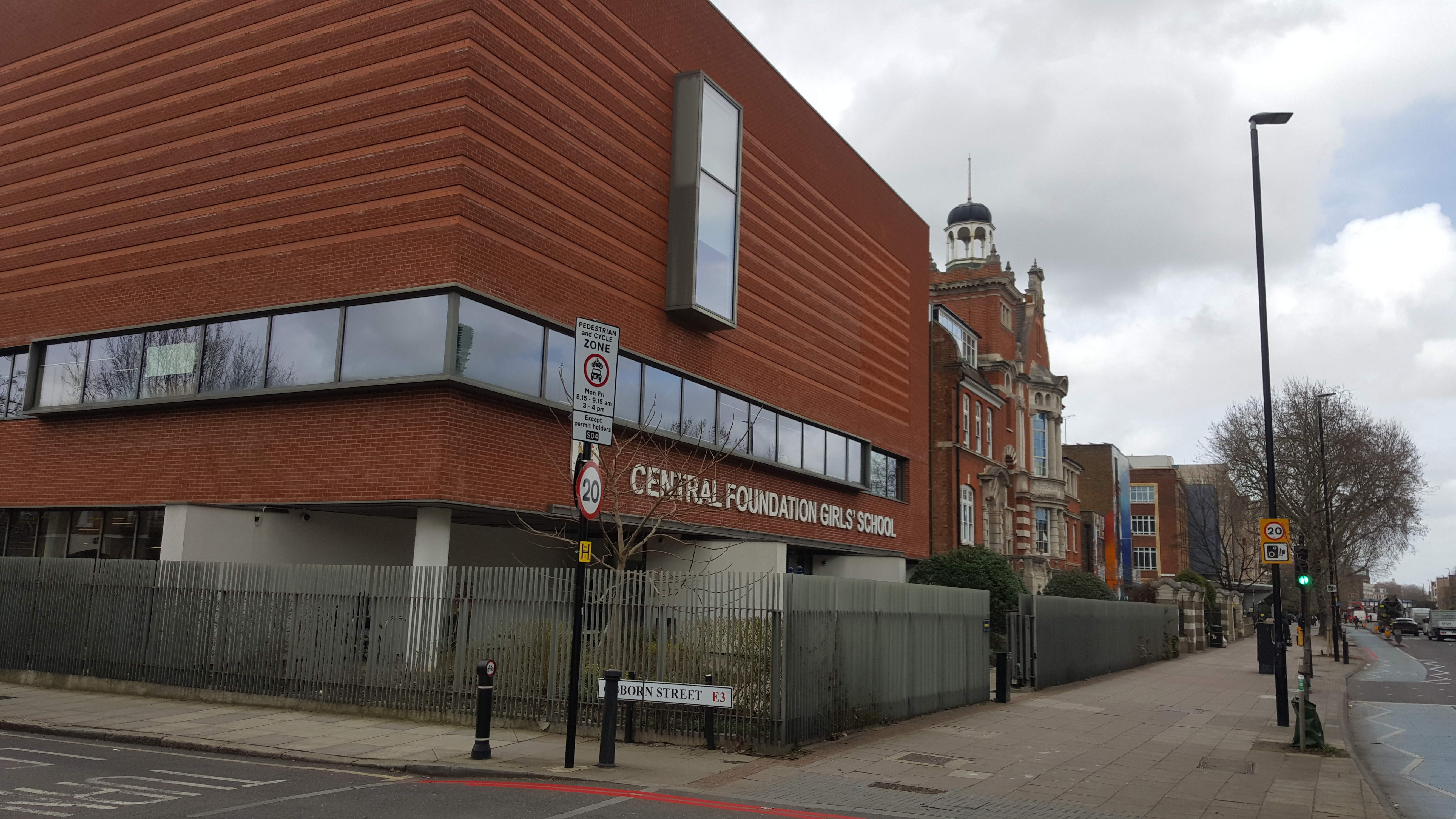
Central Foundation Girls' School

Central Foundation Girls’ School is a voluntary-aided comprehensive girls’ school in Bow, London, England, for 11- to 18-year-olds. It is the sister school...

Victoria Park & Bow railway station

Victoria Park & Bow was a short-lived railway station in Bow, east London. It was located close to the present-day Bow Junction on what is now the Great...

Bow Road tube station

Bow Road is a London Underground station located on Bow Road in Bow, London, England. It is on the District and Hammersmith & City lines. The station is...

Nearby Amenities

Located within 500m of 51.530154,-0.027055
Osm Id: 719690
Tfl Id: RWG072218
Traffic Calming: choker
Lat/Long: 51.529514/-0.0334683
Mini Roundabout
Direction: clockwise
Lat/Long: 51.5328946/-0.0240208
Bow
Is In: Tower Hamlets, London
Place: suburb
Wikidata: Q122607
Wikipedia: en:Bow, London
Lat/Long: 51.5309383/-0.0274853
Traffic Calming: table
Lat/Long: 51.5301262/-0.024881
Pub
The Morgan Arms
Addr City: London
Addr Housenumber: 43
Addr Postcode: E3 5AA
Addr Street: Morgan Street
Contact Phone: +44 20 8980 6389
Fhrs Id: 149505
Food: yes
Old Name: Playwrights
Opening Hours: Mo-Sa 12:00-23:00; Su 12:00-22:30
Real Ale: yes
Toilets: yes
Toilets Access: customers
Website: https://www.morganarmsbow.com/
Lat/Long: 51.5278869/-0.0309851
Post Box
Brand: Royal Mail
Brand Wikidata: Q638098
Collection Times: Mo-Fr 09:00; Sa 07:00
Operator: Royal Mail
Operator Wikidata: Q638098
Post Box Design: type_a
Post Box Type: pillar
Ref: E3 26D
Royal Cypher: GR
Royal Cypher Wikidata: Q33102273
Source: survey
Lat/Long: 51.5291592/-0.0267864
Crossing
Bicycle: yes
Crossing: unmarked
Lat/Long: 51.5296578/-0.0244267
Ref GB Tflcid: RWG014433
Traffic Calming: table
Lat/Long: 51.5308139/-0.0282742
Traffic Calming: table
Lat/Long: 51.5323113/-0.0280627
Post Box
Brand: Royal Mail
Brand Wikidata: Q638098
Collection Times: Mo-Fr 09:00; Sa 07:00
Operator: Royal Mail
Operator Wikidata: Q638098
Post Box Design: type_b
Post Box Type: pillar
Ref: E3 34D
Royal Cypher: EIIR
Royal Cypher Wikidata: Q33102113
Source: survey
Lat/Long: 51.5319858/-0.0232935
Traffic Calming: table
Lat/Long: 51.534424/-0.0258357
Telephone
Operator: Spectrum Interactive
Lat/Long: 51.5285272/-0.0237686
Fuel
Texaco
Addr City: London
Addr Housenumber: 127-139
Addr Postcode: E3 2AN
Addr Street: Bow Road
Brand: Texaco
Brand Wikidata: Q775060
Website: https://locations.valero.com/en-gb/LocationDetails/Index/127-139-BOW-ROAD/0000254010
Lat/Long: 51.5279792/-0.0221393
Car Sharing
Capacity: 1
Operator: Streetcar
Source: WebSite
Lat/Long: 51.5310535/-0.0223589
Car Sharing
Capacity: 1
Operator: Streetcar
Source: WebSite
Lat/Long: 51.531147/-0.024548
Bus Stop
Coborn Road
Bench: yes
Bin: yes
Local Ref: K
Naptan AtcoCode: 490012648K
Naptan Bearing: W
Naptan CommonName: St.Clements Hospital
Naptan Indicator: Stop K
Naptan Street: MILE END ROAD
Naptan Verified: yes
Public Transport: platform
Ref: 76239
Shelter: yes
Tactile Paving: no
Lat/Long: 51.526136/-0.0296037
Crossing
Crossing: uncontrolled
Crossing Island: no
Crossing Ref: zebra
Tactile Paving: yes
Lat/Long: 51.5342556/-0.0269102
Telephone
Booth: NWCapped
Check Date: 2023-05-13
Covered: booth
Mapillary: 1183142125468898
Note: not BT
Lat/Long: 51.5341652/-0.0269091
Library
Idea Store, Bow
Internet Access: wlan
Opening Hours: Mo-Th 09:00-21:00; Fr 09:00-18:00; Sa 09:00-17:00; Su 11:00-15:00
Website: https://www.ideastore.co.uk/idea-store-bow
Wikidata: Q55125877
Lat/Long: 51.5327503/-0.029746
Ref GB Tflcid: RWG014269
Traffic Calming: hump
Lat/Long: 51.5330078/-0.0297994
Doctors
St. Stephen's Health Centre
Addr City: London
Addr Housename: Bow Community Centre
Addr Housenumber: 12
Addr Postcode: E3 5ED
Addr Street: William Place
Healthcare: doctor
Wheelchair: yes
Lat/Long: 51.5322104/-0.0310944
Check Date: 2017-06-14
Ref GB Tflcid: RWG014145
Surface: sett
Traffic Calming: hump
Lat/Long: 51.5333558/-0.02453
Noexit: yes
Lat/Long: 51.5341519/-0.0240708
Ref GB Tflcid: RWG014124
Traffic Calming: table
Lat/Long: 51.5344123/-0.0253135
Giant Flower
Tourism: artwork
Lat/Long: 51.5345092/-0.0256761
Giant Flower
Tourism: artwork
Lat/Long: 51.5344398/-0.0256246
Barrier: bollard
Bicycle: no
Bollard: fixed
Foot: yes
Motor Vehicle: no
Lat/Long: 51.5331002/-0.0224089
Barrier: bollard
Bicycle: yes
Bollard: fixed
Foot: yes
Motor Vehicle: no
Lat/Long: 51.5327538/-0.0217564
Ref GB Tflcid: RWG071615
Traffic Calming: cushion
Lat/Long: 51.5281952/-0.0280423
Ref GB Tflcid: RWG071623
Traffic Calming: cushion
Lat/Long: 51.5284567/-0.0273527
Ref GB Tflcid: RWG071616
Traffic Calming: cushion
Lat/Long: 51.5286241/-0.0267921
Ref GB Tflcid: RWG071620
Traffic Calming: hump
Lat/Long: 51.529217/-0.0295279
Ref GB Tflcid: RWG072568
Traffic Calming: cushion
Lat/Long: 51.5275081/-0.0256989
Ref GB Tflcid: RWG071621
Traffic Calming: hump
Lat/Long: 51.5289834/-0.0303968
Traffic Calming: hump
Lat/Long: 51.5287918/-0.0311433
Crossing
Crossing: uncontrolled
Crossing Island: no
Crossing Ref: zebra
Kerb: flush
Tactile Paving: yes
Lat/Long: 51.527974/-0.0308473
Post Box
Brand: Royal Mail
Brand Wikidata: Q638098
Collection Times: Mo-Fr 09:00; Sa 07:00
Note: Security plate
Operator: Royal Mail
Operator Wikidata: Q638098
Post Box Design: type_b
Post Box Type: pillar
Ref: E3 18D
Royal Cypher: GVIR
Royal Cypher Wikidata: Q33102169
Source: survey
Lat/Long: 51.5290027/-0.0295045
Telephone
Atm: yes
Booth: KXPlus
Colour: white
Note: phone box converted to atm with phone on outside
Lat/Long: 51.5270716/-0.0251947
Crossing
Button Operated: yes
Crossing: traffic_signals
Crossing Island: no
Crossing Ref: pelican
Tactile Paving: yes
Traffic Signals Vibration: yes
Lat/Long: 51.5265167/-0.0284115
Ref GB Tflcid: RWG072090
Traffic Calming: cushion
Lat/Long: 51.5278913/-0.0303268
Post Box
Brand: Royal Mail
Brand Wikidata: Q638098
Collection Times: Mo-Fr 09:00; Sa 07:00
Note: Security plate
Operator: Royal Mail
Operator Wikidata: Q638098
Post Box Design: type_b
Post Box Type: pillar
Ref: E3 8D
Royal Cypher: GR
Royal Cypher Wikidata: Q33102273
Source: survey
Lat/Long: 51.5297087/-0.0207938
Recycling
Location: overground
Operator: Human Aid
Recycling Clothes: yes
Recycling Shoes: yes
Recycling Type: container
Lat/Long: 51.5304505/-0.0216447
Barrier: bollard
Bicycle: yes
Bollard: fixed
Foot: yes
Maxwidth: 1
Motorcycle: no
Lat/Long: 51.5303785/-0.034076
Addr Housenumber: 23
Addr Street: Viking Close
Lat/Long: 51.5303286/-0.0339109
Addr Housenumber: 18
Addr Street: Viking Close
Lat/Long: 51.5303802/-0.0337357
Addr Housenumber: 24
Addr Street: Stanfield Road
Lat/Long: 51.5302243/-0.0341977
Addr Housenumber: 136
Addr Street: Antill Road
Lat/Long: 51.5296672/-0.0325055
Bicycle Parking
Bicycle Parking: stands
Capacity: 12
Covered: no
Mapillary: 1164796450637944
Survey Date: 2019-01-19
Lat/Long: 51.5327644/-0.029528
Parking
Fee: yes
Parking: surface
Lat/Long: 51.5325376/-0.032714
Barrier: bollard
Bicycle: yes
Foot: yes
Motor Vehicle: no
Lat/Long: 51.5321864/-0.0313508
Telephone
Booth: KX100
Check Date: 2024-03-29
Covered: booth
Lat/Long: 51.5329047/-0.0303158
Toilets
Fee: yes
Lat/Long: 51.532468/-0.0328813
Ace Cars London Ltd
Addr City: London
Addr Housenumber: 503
Addr Street: Roman Road
Contact Phone: +44 20 8980 6666
Contact Website: http://acecarslondonltd.com/
Level: 0
Office: taxi
Shop: taxi
Lat/Long: 51.532343/-0.0331182
Fast Food
Chilli Garlic Restaurant
Addr City: London
Addr Housenumber: 501
Addr Postcode: E3 5LX
Addr Street: Roman Road
Fhrs Id: 703314
Fhrs Local Authority Id: 156162
Level: 0
Old Name: The Saucy Plaice
Lat/Long: 51.5323313/-0.0331805
Roman Furniture
Addr City: London
Addr Housenumber: 497-499
Addr Street: Roman Road
Level: 0
Shop: furniture
Lat/Long: 51.5323139/-0.033274
Laxmi news
Addr City: London
Addr Housenumber: 495
Addr Postcode: E3 5LX
Addr Street: Roman Road
Fhrs Id: 362567
Fhrs Local Authority Id: 9656
Level: 0
Shop: newsagent
Lat/Long: 51.5322964/-0.0333675
Addr Housenumber: 33
Addr Street: St Stephen's Road
Lat/Long: 51.5311311/-0.031511
Bus Stop
Bow Road Station
Bench: yes
Bin: no
Local Ref: Y
Naptan AtcoCode: 490000029Q
Naptan Bearing: E
Naptan CommonName: Bow Road
Naptan Indicator: Stop Q
Naptan Street: BOW ROAD
Naptan Verified: yes
Public Transport: platform
Ref: 77923
Shelter: yes
Lat/Long: 51.5271238/-0.0257555
Bus Stop
Bow Road Station
Bench: yes
Bin: no
Bus: yes
Local Ref: Z
Naptan AtcoCode: 490000029Z
Naptan Bearing: W
Naptan CommonName: Bow Road
Naptan Indicator: Stop Z
Naptan Street: BOW ROAD
Naptan Verified: yes
Public Transport: platform
Ref: 55489
Shelter: yes
Tactile Paving: no
Lat/Long: 51.5273425/-0.0239685
Bus Stop
Bow Bus Garage
Bench: yes
Bin: no
Lit: yes
Local Ref: D
Naptan AtcoCode: 490004205D
Naptan Bearing: N
Naptan CommonName: Bow Bus Garage
Naptan Indicator: D
Naptan Street: FAIRFIELD ROAD
Public Transport: platform
Ref: 77564
Shelter: yes
Tactile Paving: no
Lat/Long: 51.529903/-0.0210716
Bus Stop
Bow Road
Bench: no
Bin: no
Bus: yes
Lit: yes
Local Ref: S
Naptan AtcoCode: 490004209Y
Naptan Bearing: N
Naptan CommonName: Bow Church Campbell Road
Naptan Indicator: S
Naptan Street: CAMPBELL ROAD
Public Transport: platform
Ref: 48519
Shelter: no
Tactile Paving: no
Lat/Long: 51.5275184/-0.0215535
Bus Stop
Ford Road
Bench: no
Bin: no
Bus: yes
Check Date Shelter: 2024-03-29
Local Ref: K
Naptan AtcoCode: 490006904E
Naptan Bearing: E
Naptan CommonName: Ford Road
Naptan Indicator: Stop RL
Naptan Street: ROMAN ROAD
Passenger Information Display: no
Public Transport: platform
Ref: 47585
Shelter: no
Tactile Paving: no
Lat/Long: 51.53225/-0.0334145
Bus Stop
Ford Road
Bench: no
Bin: yes
Bus: yes
Covered: no
Lit: no
Local Ref: B
Naptan AtcoCode: 490006904W
Naptan Bearing: W
Naptan CommonName: Ford Road
Naptan Indicator: Stop RR
Naptan Street: ROMAN ROAD
Public Transport: platform
Ref: 54466
Shelter: no
Tactile Paving: no
Lat/Long: 51.5322237/-0.0329013
Bus Stop
Roman Road Market
Bench: yes
Bin: yes
Covered: no
Lit: yes
Local Ref: OA
Naptan AtcoCode: 490011654N
Naptan Bearing: N
Naptan CommonName: Roman Road Market
Naptan Indicator: Stop OA
Naptan Street: PARNELL ROAD
Public Transport: platform
Ref: 53803
Shelter: yes
Tactile Paving: no
Lat/Long: 51.5333007/-0.0261001
Bus Stop
Coborn Road
Bench: yes
Local Ref: L
Naptan AtcoCode: 490012648L
Naptan Bearing: E
Naptan CommonName: St.Clements Hospital
Naptan Indicator: Stop L
Naptan Street: BOW ROAD
Naptan Verified: yes
Public Transport: platform
Ref: 48288
Shelter: yes
Lat/Long: 51.5263626/-0.0291807
Bus Stop
Tredegar Road
Bench: yes
Bin: yes
Lit: yes
Local Ref: P
Naptan AtcoCode: 490013779N
Naptan Bearing: N
Naptan CommonName: Tredegar Road
Naptan Indicator: P
Public Transport: platform
Ref: 72071
Shelter: yes
Tactile Paving: no
Lat/Long: 51.5324973/-0.0237846
Bus Stop
Tredegar Road
Bench: no
Bin: no
Lit: yes
Local Ref: Q
Naptan AtcoCode: 490013779S
Naptan Bearing: S
Naptan CommonName: Tredegar Road
Naptan Indicator: Q
Public Transport: platform
Ref: 54220
Shelter: no
Tactile Paving: no
Lat/Long: 51.5321471/-0.0232807
Bus Stop
Usher Road
Bench: no
Bin: no
Bus: yes
Lit: no
Local Ref: E
Naptan AtcoCode: 490015683E
Naptan Bearing: E
Naptan CommonName: Usher Road
Naptan Indicator: TV
Naptan Street: TREDEGAR ROAD
Public Transport: platform
Ref: 53837
Shelter: no
Source Local Ref: Bing Streetside
Tactile Paving: no
Lat/Long: 51.5320334/-0.0260047
Bus Stop
Usher Road
Bench: no
Bin: yes
Bus: yes
Lit: yes
Local Ref: N
Naptan AtcoCode: 490015683W
Naptan Bearing: W
Naptan CommonName: Usher Road
Naptan Indicator: TW
Naptan Street: TREDEGAR ROAD
Public Transport: platform
Ref: 58112
Shelter: no
Source Local Ref: mapillary image
Tactile Paving: no
Lat/Long: 51.5319971/-0.0258329
Bus Stop
Shetland Road
Bus: yes
Local Ref: TX
Naptan AtcoCode: 490015684W
Naptan Bearing: W
Naptan CommonName: Shetland Road
Naptan Indicator: TX
Naptan Street: TREDEGAR ROAD
Public Transport: platform
Ref: 76649
Lat/Long: 51.5304174/-0.0289787
Bus Stop
Antill Road
Bus: yes
Local Ref: SL
Naptan AtcoCode: 490015685E
Naptan Bearing: E
Naptan CommonName: Clayhall Court
Naptan Indicator: SL
Naptan Street: ST STEPHENS ROAD
Public Transport: platform
Ref: 56937
Route Ref: 339
Shelter: no
Towards: Fish Island
Lat/Long: 51.5302129/-0.0305114
Cycleway: asl
Direction: backward
Lat/Long: 51.5326159/-0.032421
Traffic Signals
Crossing: no
Traffic Signals: traffic_lights
Traffic Signals Direction: forward
Lat/Long: 51.5323503/-0.0326311
Crossing
Button Operated: yes
Crossing: traffic_signals
Crossing Island: yes
Crossing Ref: pelican
Tactile Paving: yes
Lat/Long: 51.5324075/-0.0325193
Ref GB Tflcid: RWG014399
Traffic Calming: hump
Lat/Long: 51.5320907/-0.0316763
Ref GB Tflcid: RWG014437
Traffic Calming: cushion
Lat/Long: 51.5305655/-0.0308626
Crossing
Crossing: unmarked
Lat/Long: 51.5317533/-0.0304242
Ref GB Tflcid: RWG014304
Traffic Calming: cushion
Lat/Long: 51.5331823/-0.0268724
Noexit: yes
Lat/Long: 51.5258856/-0.0271996
Curve Geometry: yes
Lat/Long: 51.5261137/-0.0287258
Telephone
Booth: K6
Covered: booth
Listed Status: Grade II
Lat/Long: 51.5269081/-0.0258932
Ref GB Tflcid: RWG071624
Traffic Calming: cushion
Lat/Long: 51.5286071/-0.0264253
Crossing
Button Operated: yes
Crossing: traffic_signals
Crossing Island: no
Crossing Ref: pelican
Tactile Paving: yes
Traffic Signals Vibration: yes
Lat/Long: 51.5272531/-0.0250724
Post Box
Brand: Royal Mail
Brand Wikidata: Q638098
Collection Times: Mo-Fr 09:00; Sa 07:00
Operator: Royal Mail
Operator Wikidata: Q638098
Post Box Design: type_a
Post Box Type: pillar
Ref: E3 30D
Royal Cypher: GR
Royal Cypher Wikidata: Q33102273
Source: survey
Lat/Long: 51.5277879/-0.0231663
Cafe
Mighty Bite
Addr City: London
Addr Housenumber: 123
Addr Postcode: E3 2AN
Addr Street: Bow Road
Fhrs Id: 149239
Source Addr: FHRS Open Data
Lat/Long: 51.5278179/-0.0226269
Noexit: yes
Lat/Long: 51.5270714/-0.0218345
Entrance: main
Lat/Long: 51.5336317/-0.0283057
Community Centre
Antill Road Centre
Addr City: London
Addr Housenumber: 109a
Addr Postcode: E3 5BW
Addr Street: Antill Road
Fhrs Id: 76288
Url: http://www.thecamdensociety.co.uk/antill
Lat/Long: 51.5297334/-0.0331166
Cornucopia
Addr City: London
Addr Housename: Bevan Court Shop Unit
Addr Housenumber: 246
Addr Postcode: E3 2GP
Addr Street: Tredegar Road
Fhrs Id: 65925
Shop: convenience
Source Addr: FHRS Open Data
Lat/Long: 51.5316068/-0.0265055
Atm
Description: Tesco ATM
Operator: Tesco Bank
Lat/Long: 51.5262272/-0.0288264
Shop: optician
Lat/Long: 51.5280285/-0.0216265
Source: Bing
Lat/Long: 51.5296056/-0.021135
Source: Bing
Lat/Long: 51.529582/-0.0211863
Source: Bing
Lat/Long: 51.5295885/-0.021194
Source: Bing
Lat/Long: 51.5295692/-0.0212362
Source: Bing
Lat/Long: 51.5295844/-0.0212543
Source: Bing
Lat/Long: 51.5296273/-0.0211608
Noexit: yes
Lat/Long: 51.5281343/-0.0209528
Bicycle Parking
Bicycle Parking: stands
Capacity: 4
Covered: no
Lat/Long: 51.5274804/-0.0232619
Ref GB Tflcid: RWG071230
Traffic Calming: cushion
Lat/Long: 51.5260694/-0.0251604
Bow Road
Historic Railway: station
Railway: site
Wikidata: Q4950655
Wikipedia: en:Bow Road railway station
Lat/Long: 51.5281452/-0.0229198
Railway: switch
Lat/Long: 51.5311109/-0.0202668
Railway: switch
Lat/Long: 51.5288951/-0.0217839
Coborn Road
Abandoned Railway: station
Railway: site
Source: Bing
Lat/Long: 51.5288559/-0.0329778
Bicycle Rental
Merchant Street
Bicycle Rental: docking_station
Brand: Santander Cycles
Brand Wikidata: Q807961
Capacity: 27
Local: Bow
Network: tfl_cycle_hire
Official Name: Merchant Street, Bow
Official Ref: 497
Operator: Serco
Lat/Long: 51.526511/-0.0277575
Bow Road
Name Ru: Боу-роуд
Network: London Underground
Operator: London Underground
Public Transport: stop_position
Railway: stop
Subway: yes
Lat/Long: 51.5268754/-0.0248073
Bow Road
Name Ru: Боу-роуд
Network: London Underground
Operator: London Underground
Public Transport: stop_position
Railway: stop
Subway: yes
Lat/Long: 51.5269047/-0.0247947
Bicycle Rental
Ford Road
Bicycle Rental: docking_station
Brand: Santander Cycles
Brand Wikidata: Q807961
Capacity: 18
Local: Old Ford
Network: tfl_cycle_hire
Official Name: Ford Road, Old Ford
Official Ref: 517
Operator: Serco
Payment Credit Cards: yes
Lat/Long: 51.5325055/-0.0329675
Bicycle Rental
Hewison Street
Bicycle Rental: docking_station
Brand: Santander Cycles
Brand Wikidata: Q807961
Capacity: 18
Local: Old Ford
Network: tfl_cycle_hire
Official Name: Hewison Street, Old Ford
Official Ref: 471
Operator: Serco
Payment Credit Cards: yes
Lat/Long: 51.5332329/-0.0280081
Bicycle Rental
Mostyn Grove
Bicycle Rental: docking_station
Brand: Santander Cycles
Brand Wikidata: Q807961
Capacity: 46
Local: Bow
Network: tfl_cycle_hire
Official Name: Mostyn Grove, Bow
Official Ref: 470
Operator: Serco
Lat/Long: 51.5305085/-0.0254478
Bicycle Rental
Malmesbury Road
Bicycle Rental: docking_station
Brand: Santander Cycles
Brand Wikidata: Q807961
Capacity: 21
Local: Bow
Network: tfl_cycle_hire
Official Name: Malmesbury Road, Bow
Official Ref: 472
Operator: Serco
Lat/Long: 51.5294286/-0.0276004
Source: bing
Traffic Calming: cushion
Lat/Long: 51.5269781/-0.0291415
Source: bing
Traffic Calming: cushion
Lat/Long: 51.5273064/-0.0293459
Source: bing
Traffic Calming: cushion
Lat/Long: 51.5277058/-0.0295991
Source: bing
Traffic Calming: cushion
Lat/Long: 51.5279128/-0.0302359
Crossing
Crossing: unmarked
Crossing Island: no
Tactile Paving: yes
Traffic Calming: table
Lat/Long: 51.5269595/-0.0256622
Vending Machine
Source: survey
Vending: parking_tickets
Lat/Long: 51.530168/-0.0314015
Crossing
Crossing: uncontrolled
Crossing Ref: zebra
Source: Bing;survey
Lat/Long: 51.530092/-0.0299486
Note: 20 mph speed limit sign eastbound
Lat/Long: 51.5303021/-0.0308254
Car Rental
Operator: Enterprise
Lat/Long: 51.5281447/-0.0207977
Asda
Addr City: London
Addr Housenumber: 127-131
Addr Postcode: E3 2AN
Addr Street: Bow Road
Brand: Asda
Brand Wikidata: Q297410
Fhrs Id: 100122
Fhrs Local Authority Id: 3202
Opening Hours: 08:00-21:00
Operator: Asda
Operator Wikidata: Q117202
Shop: convenience
Source Addr: FHRS Open Data
Lat/Long: 51.5281153/-0.0218899
Maxwidth: 4.76
Note: Also signed in imperial units 15'3
Lat/Long: 51.527755/-0.0232371
The Roman Baths
Covered: yes
Shop: bathroom_furnishing
Source: +44 20 8983 5445
Sport: swimming
Lat/Long: 51.5327746/-0.03212
Fast Food
Kam Hon
Addr City: London
Addr Housenumber: 13
Addr Postcode: E3 2DA
Addr Street: Coborn Road
Cuisine: chinese
Fhrs Id: 149271
Source: survey
Lat/Long: 51.5268113/-0.0303399
Noexit: yes
Lat/Long: 51.5266055/-0.0242355
Crossing
Crossing: unmarked
Tactile Paving: yes
Lat/Long: 51.5334832/-0.022214
Crossing
Crossing: unmarked
Tactile Paving: yes
Lat/Long: 51.5336057/-0.0224485
East London Man With a Van
Addr City: London
Addr Street: Fairfield Road
Check Date: 2023-01-18
Currency XBT: yes
Note: London based removals and courier service.
Office: yes
Payment Lightning: yes
Payment Onchain: yes
Phone: +44 7507662557
Website: https://eastlondonmanwithavan.com/
Lat/Long: 51.5297682/-0.0210926
Addr City: London
Addr Housenumber: 46-52
Addr Street: Fairfield Road
Lat/Long: 51.5303823/-0.0212428
Operator: UK Power Networks
Operator Wikidata: Q7864927
Power: substation
Ref: 67004
Lat/Long: 51.5307522/-0.0218408
Cafe
G. Kelly
Addr City: London
Addr Housenumber: 526
Addr Postcode: E3 5ES
Addr Street: Roman Road
Cuisine: pie_and_mash
Diet Vegan: yes
Diet Vegetarian: yes
Fhrs Id: 149770
Fhrs Local Authority Id: 9662
Opening Hours: Tu,We,Su 11:00-16:00;Th 11:00-19:00;Fr-Sa 10:00-19:00
Smoking: no
Source Addr Postcode: FHRS Open Data
Start Date: 1939
Lat/Long: 51.5323778/-0.0314852
Coborn Motors
Addr Housenumber: 57-59
Addr Street: Coborn Road
Shop: car_repair
Start Date: 1960
Lat/Long: 51.528183/-0.0311128
Addr City: London
Addr Housenumber: 100
Addr Postcode: E3 2DG
Addr Street: Coborn Road
Disused Shop: yes
Old Name: Bed Shop
Lat/Long: 51.5293631/-0.0316528
Addr Housenumber: 19
Addr Street: Norman Grove
Lat/Long: 51.5310575/-0.0337684
Addr Housenumber: 1
Addr Street: Norman Grove
Lat/Long: 51.5306769/-0.0333722
Addr Housenumber: 33
Addr Street: Norman Grove
Lat/Long: 51.5313124/-0.033972
Crossing
Crossing: uncontrolled
Crossing Island: no
Tactile Paving: yes
Lat/Long: 51.5300349/-0.030437
Addr Housenumber: 33
Addr Street: Usher Road
Lat/Long: 51.5328477/-0.0267414
Addr Housenumber: 63
Addr Street: Usher Road
Lat/Long: 51.5334497/-0.027428
Addr Housenumber: 137
Addr Street: Tredegar Road
Lat/Long: 51.5317934/-0.0265979
Addr Housenumber: 90
Addr Street: Tredegar Road
Lat/Long: 51.5308523/-0.0279143
Addr Housenumber: 127
Addr Street: Tredegar Road
Lat/Long: 51.5315808/-0.0270409
Addr Housenumber: 147
Addr Street: Fairfield Road
Lat/Long: 51.532551/-0.0238848
Addr Housenumber: 49
Addr Street: Fairfield Road
Lat/Long: 51.5297343/-0.0211905
Addr Housenumber: 51
Addr Street: Fairfield Road
Lat/Long: 51.5298572/-0.0212705
Addr Housenumber: 68
Addr Street: Tredegar Road
Lat/Long: 51.530503/-0.0286784
Addr Housenumber: 129
Addr Street: Fairfield Road
Lat/Long: 51.53222/-0.0236108
Addr Housenumber: 82
Addr Street: Tredegar Road
Lat/Long: 51.5306769/-0.0282657
Addr Housenumber: 84
Addr Street: Tredegar Road
Lat/Long: 51.5307534/-0.028126
Addr Housenumber: 9
Addr Street: Fairfield Road
Lat/Long: 51.5289663/-0.0202711
Post Box
Brand: Royal Mail
Brand Wikidata: Q638098
Collection Times: Mo-Fr 16:00; Sa 11:30
Note: Security plate
Operator: Royal Mail
Operator Wikidata: Q638098
Post Box Design: type_a
Post Box Type: pillar
Ref: E3 16
Royal Cypher: VR
Royal Cypher Wikidata: Q33102356
Source: survey
Lat/Long: 51.530306/-0.0291784
Ford Road
Bus: yes
Local Ref: B
Public Transport: stop_position
Lat/Long: 51.5322809/-0.0329107
Roman Road Market
Bus: yes
Local Ref: OA
Public Transport: stop_position
Lat/Long: 51.5333224/-0.0259876
Crossing
Check Date: 2018-02-16
Crossing: uncontrolled
Crossing Island: no
Crossing Markings: zebra
Crossing Ref: zebra
Kerb: flush
Ref GB Tflcid: RWG999834
Tactile Paving: yes
Traffic Calming: table
Lat/Long: 51.5263538/-0.0293037
Traffic Signals
Crossing: no
Traffic Signals: traffic_lights
Traffic Signals Direction: forward
Lat/Long: 51.5323802/-0.032064
Railway: subway_entrance
Lat/Long: 51.5269897/-0.0248212
Motorcycle Parking
Addr City: London
Addr Country: GB
Covered: yes
Lat/Long: 51.5294831/-0.0314202
Crossing
Button Operated: yes
Crossing: traffic_signals
Crossing Island: no
Crossing Ref: pelican
Kerb: flush
Tactile Paving: yes
Traffic Signals Sound: no
Traffic Signals Vibration: yes
Lat/Long: 51.5323982/-0.0322821
Bow Road
Bus: yes
Local Ref: S
Public Transport: stop_position
Lat/Long: 51.5275375/-0.0214781
Crossing
Crossing: marked
Crossing Island: no
Tactile Paving: yes
Lat/Long: 51.532532/-0.0250791
Check Date: 2017-06-14
Ref GB Tflcid: RWG014146
Surface: sett
Traffic Calming: hump
Lat/Long: 51.5335785/-0.0232193
Tesco Express
Addr City: London
Addr Housename: Merchants Quarter
Addr Postcode: E3 2AD
Addr Street: Bow Road
Addr Unit: Unit 1-5
Branch: Bow Merchants Quarter Express
Brand: Tesco Express
Brand Wikidata: Q98456772
Check Date: 2023-04-09
Contact Website: https://www.tesco.com/store-locator/london/1-5-merchants-quarter
Fhrs Id: 65927
Fhrs Local Authority Id: 148456
Name Fa: تسکو اکسپرس
Opening Hours: Mo-Su 06:00-23:00
Ref: 5898
Shop: convenience
Source Addr: FHRS Open Data
Wheelchair: yes
Lat/Long: 51.5263226/-0.0283293
Addr Housename: Flats 1-29
Entrance: yes
Lat/Long: 51.5263783/-0.0281069
Old Ford
Place: quarter
Wikidata: Q124163
Wikipedia: en:Old Ford
Lat/Long: 51.5341124/-0.0268215
Ford Road
Bus: yes
Local Ref: K
Public Transport: stop_position
Lat/Long: 51.5321821/-0.0334437
Antill Road
Bus: yes
Local Ref: SL
Public Transport: stop_position
Ref GB Tflcid: RWG014438
Traffic Calming: cushion
Lat/Long: 51.5302018/-0.0305781
Shetland Road
Bus: yes
Local Ref: TX
Public Transport: stop_position
Lat/Long: 51.5304725/-0.0290527
Usher Road
Bus: yes
Local Ref: M
Public Transport: stop_position
Lat/Long: 51.5320013/-0.0260044
Usher Road
Bus: yes
Local Ref: N
Public Transport: stop_position
Lat/Long: 51.5320485/-0.0259039
Clinic
London Physiotherapy and Wellness
Healthcare: physiotherapist
Healthcare Speciality: physiotherapy
Lat/Long: 51.5303264/-0.0212786
Noexit: yes
Lat/Long: 51.5258397/-0.0274331
Grit Bin
Lat/Long: 51.5259387/-0.0264102
Entrance: yes
Lat/Long: 51.5261983/-0.025436
Addr Housenumber: 64
Addr Street: Tredegar Square
Lat/Long: 51.5267233/-0.0314336
Addr Housenumber: 27
Addr Street: Morgan Street
Lat/Long: 51.5277216/-0.0317964
Addr Housenumber: 41
Addr Street: Morgan Street
Lat/Long: 51.5278166/-0.0313365
Addr Housenumber: 22
Addr Street: Tredegar Square
Lat/Long: 51.5275583/-0.0315942
Addr Housenumber: 1
Addr Street: Tredegar Square
Lat/Long: 51.5265843/-0.0310656
Addr Housenumber: 20
Addr Street: Morgan Street
Lat/Long: 51.5277242/-0.0308279
Addr Housenumber: 10
Addr Street: Morgan Street
Lat/Long: 51.5276306/-0.0312436
Addr Housenumber: 7
Addr Street: Tiber Close
Lat/Long: 51.5342444/-0.0242614
Addr Housenumber: 1
Addr Street: Tiber Close
Lat/Long: 51.5341468/-0.0246144
Addr Housenumber: 17
Addr Street: Forum Close
Lat/Long: 51.5344039/-0.024786
Addr Housenumber: 16
Addr Street: Tiber Close
Lat/Long: 51.5340336/-0.0239519
Addr Housenumber: 22
Addr Street: Tiber Close
Lat/Long: 51.5339027/-0.0244118
Addr Housenumber: 15
Addr Street: Tiber Close
Lat/Long: 51.5340596/-0.0235747
Addr Housenumber: 7
Addr Street: Garrison Road
Lat/Long: 51.5342757/-0.0249813
Addr Housenumber: 4
Addr Street: Garrison Road
Lat/Long: 51.5341374/-0.0248738
Addr Housenumber: 8
Addr Street: Pancras Way
Lat/Long: 51.5335124/-0.0246169
Addr Housenumber: 38
Addr Street: Pancras Way
Lat/Long: 51.5338008/-0.0236897
Addr Housenumber: 50
Addr Street: Pancras Way
Lat/Long: 51.5328322/-0.0251522
Addr Housenumber: 44
Addr Street: Pancras Way
Lat/Long: 51.5329223/-0.0249523
Addr Housenumber: 2
Addr Street: Lefevre Walk
Lat/Long: 51.5330899/-0.0254634
Addr Housenumber: 10
Addr Street: Lefevre Walk
Lat/Long: 51.5331948/-0.0252315
Addr Housenumber: 1
Addr Street: Lefevre Walk
Lat/Long: 51.5333245/-0.0256132
Addr Housenumber: 9
Addr Street: Lefevre Walk
Lat/Long: 51.5334294/-0.0253813
Addr Housenumber: 17
Addr Street: Lefevre Walk
Lat/Long: 51.5338806/-0.0256387
Addr Housenumber: 19
Addr Street: Lefevre Walk
Lat/Long: 51.5339396/-0.0256948
Addr Housenumber: 643
Addr Street: Roman Road
Lat/Long: 51.5344116/-0.0261984
Addr Housenumber: 635
Addr Street: Roman Road
Lat/Long: 51.534334/-0.0264377
Addr Housenumber: 1
Addr Street: Legion Terrace
Lat/Long: 51.5345633/-0.0260736
Addr Housenumber: 6
Addr Street: Tamar Close
Lat/Long: 51.534643/-0.0266713
Addr Housenumber: 76
Addr Street: Parnell Road
Lat/Long: 51.5344769/-0.0267898
Addr Housenumber: 80
Addr Street: Parnell Road
Lat/Long: 51.5345758/-0.0268674
Restaurant
Sultan Sofrasi
Addr City: London
Addr Housenumber: 72
Addr Postcode: E3 2RU
Addr Street: Parnell Road
Cuisine: indian
Fhrs Id: 458893
Lat/Long: 51.534071/-0.0266025
Addr Housenumber: 17
Addr Street: Douro Street
Lat/Long: 51.5329227/-0.0230523
Addr Housenumber: 27
Addr Street: Douro Street
Lat/Long: 51.5328621/-0.0233589
Addr Housenumber: 5
Addr Street: Douro Street
Lat/Long: 51.5329631/-0.0227523
Addr Housenumber: 11
Addr Street: Douro Street
Lat/Long: 51.532925/-0.0229613
Addr Housenumber: 1
Addr Street: Vincent Mews
Lat/Long: 51.532217/-0.0232553
Addr Housenumber: 5
Addr Street: Vincent Mews
Lat/Long: 51.5322953/-0.023007
Addr Housenumber: 4
Addr Street: Blondin Street
Lat/Long: 51.5319512/-0.0227797
Addr Housenumber: 24
Addr Street: Blondin Street
Lat/Long: 51.5322258/-0.0223006
Addr Housenumber: 26
Addr Street: Blondin Street
Lat/Long: 51.5323016/-0.0221854
Addr Housenumber: 40
Addr Street: Blondin Street
Lat/Long: 51.532492/-0.0218504
Addr Housenumber: 42
Addr Street: Blondin Street
Lat/Long: 51.532557/-0.0218336
Addr Housenumber: 50
Addr Street: Blondin Street
Lat/Long: 51.5326674/-0.0216517
Addr Housenumber: 2
Addr Street: Four Seasons Close
Lat/Long: 51.5319313/-0.0248974
Addr Housenumber: 26
Addr Street: Four Seasons Close
Lat/Long: 51.5322595/-0.0242086
Addr Housenumber: 1
Addr Street: Cherrywood Close
Lat/Long: 51.5291346/-0.0332883
Addr Housenumber: 6
Addr Street: Cherrywood Close
Lat/Long: 51.5289715/-0.0331822
Addr Housenumber: 1
Addr Street: Cherrywood Close
Lat/Long: 51.5288691/-0.0339677
Addr Housenumber: 48
Addr Street: Lichfield Road
Lat/Long: 51.528311/-0.0335787
Addr Housenumber: 79
Addr Street: Lichfield Road
Lat/Long: 51.5283657/-0.0333594
Addr Housenumber: 48
Addr Street: Lichfield Road
Lat/Long: 51.5288075/-0.0315107
Addr Housenumber: 1
Addr Street: Malmesbury Road
Lat/Long: 51.5288609/-0.0311956
Addr Housenumber: 5
Addr Street: Malmesbury Road
Lat/Long: 51.5289267/-0.0312261
Addr Housenumber: 13
Addr Street: Malmesbury Road
Lat/Long: 51.5290204/-0.0312086
Addr Housenumber: 61
Addr Street: Malmesbury Road
Lat/Long: 51.5292265/-0.0300087
Addr Housenumber: 63
Addr Street: Malmesbury Road
Lat/Long: 51.5292558/-0.029923
Addr Housenumber: 67
Addr Street: Malmesbury Road
Lat/Long: 51.5292008/-0.0299022
Addr Housenumber: 3
Addr Street: Montague Mews
Lat/Long: 51.5280538/-0.0317139
Addr Housenumber: 7
Addr Street: Montague Mews
Lat/Long: 51.5281071/-0.0314779
Addr Housenumber: 1
Addr Street: Tredegar Mews
Lat/Long: 51.5279654/-0.0319413
Addr Housenumber: 4
Addr Street: Tredegar Mews
Lat/Long: 51.5280096/-0.0317504
Addr Housenumber: 1
Addr Street: Shetland Road
Lat/Long: 51.5308411/-0.029208
Addr Housenumber: 3
Addr Street: Shetland Road
Lat/Long: 51.5309405/-0.0292819
Addr Housenumber: 55
Addr Street: St Stephen's Road
Lat/Long: 51.5316847/-0.0319836
Addr Housenumber: 69
Addr Street: St Stephen's Road
Lat/Long: 51.5319758/-0.0321742
Addr Housenumber: 79
Addr Street: Armagh Road
Lat/Long: 51.5339336/-0.0288393
Addr Housenumber: 67
Addr Street: Armagh Road
Lat/Long: 51.533753/-0.0287139
Addr Housenumber: 1
Addr Street: Mostyn Grove
Lat/Long: 51.5305213/-0.0248355
Addr Housenumber: 4
Addr Street: Mostyn Grove
Lat/Long: 51.5304502/-0.0249794
Addr Housenumber: 7
Addr Street: Mostyn Grove
Lat/Long: 51.530577/-0.0251427
Addr Housenumber: 276
Addr Street: Morville Street
Lat/Long: 51.5302496/-0.0248753
Addr Housenumber: 272
Addr Street: Morville Street
Lat/Long: 51.5303251/-0.0247156
Addr Housenumber: 270
Addr Street: Morville Street
Lat/Long: 51.5303772/-0.0246251
Addr Housenumber: 262
Addr Street: Morville Street
Lat/Long: 51.530501/-0.0243813
Addr Housenumber: 1
Addr Street: Athelstane Grove
Lat/Long: 51.5305135/-0.0312936
Addr Housenumber: 19
Addr Street: Athelstane Grove
Lat/Long: 51.5301321/-0.0324963
Addr Housenumber: 38
Addr Street: Athelstane Grove
Lat/Long: 51.530647/-0.0315218
Addr Housenumber: 23
Addr Street: Athelstane Grove
Lat/Long: 51.5303612/-0.0324597
Addr Housenumber: 40
Addr Street: Saxon Road
Lat/Long: 51.5310915/-0.0317168
Addr Housenumber: 14
Addr Street: Saxon Road
Lat/Long: 51.5308412/-0.0325266
Addr Housenumber: 13
Addr Street: St Stephen's Road
Lat/Long: 51.5307539/-0.031195
Addr Housenumber: 13
Addr Street: St Stephen's Road
Lat/Long: 51.5303943/-0.0308992
Addr Housenumber: 33
Addr Street: St Stephen's Road
Lat/Long: 51.5305839/-0.0310612
Addr Housenumber: 29
Addr Street: Lyal Road
Lat/Long: 51.5304431/-0.0340813
Addr Housenumber: 27
Addr Street: Selwyn Road
Lat/Long: 51.530475/-0.0334307
Addr Housenumber: 7
Addr Street: Selwyn Road
Lat/Long: 51.5300923/-0.0331153
Addr Housenumber: 1
Addr Street: Selwyn Road
Lat/Long: 51.5298917/-0.0329864
Addr Housenumber: 5
Addr Street: Selwyn Road
Lat/Long: 51.5299835/-0.0330539
Addr Housenumber: 2
Addr Street: Cardigan Road
Lat/Long: 51.5317948/-0.0272318
Addr Housenumber: 34
Addr Street: Cardigan Road
Lat/Long: 51.5323411/-0.0279337
Addr Housenumber: 36
Addr Street: Cardigan Road
Lat/Long: 51.5323909/-0.027943
Addr Housenumber: 60
Addr Street: Cardigan Road
Lat/Long: 51.53282/-0.0283696
Addr Housenumber: 600
Addr Street: Roman Road
Lat/Long: 51.5335745/-0.0279659
Addr Housenumber: 610
Addr Street: Roman Road
Lat/Long: 51.5337222/-0.027589
Addr Housenumber: 67
Addr Street: Usher Road
Lat/Long: 51.5336412/-0.0275037
Addr Housenumber: 1
Addr Street: Usher Road
Lat/Long: 51.5321678/-0.0260149
Addr Housenumber: 31
Addr Street: Usher Road
Lat/Long: 51.5327576/-0.0266941
Addr Housenumber: 95
Addr Street: Hewison Street
Lat/Long: 51.5320714/-0.0262798
Addr Housenumber: 87
Addr Street: Hewison Street
Lat/Long: 51.5319876/-0.0264683
Addr Housenumber: 84
Addr Street: Hewison Street
Lat/Long: 51.531897/-0.02668
Addr Housenumber: 78
Addr Street: Hewison Street
Lat/Long: 51.5320036/-0.0267975
Addr Housenumber: 60
Addr Street: Hewison Street
Lat/Long: 51.5322618/-0.027153
Addr Housenumber: 40
Addr Street: Hewison Street
Lat/Long: 51.5325402/-0.0274832
Addr Housenumber: 38
Addr Street: Hewison Street
Lat/Long: 51.5325785/-0.0275271
Addr Housenumber: 24
Addr Street: Hewison Street
Lat/Long: 51.5327733/-0.0277166
Addr Housenumber: 63
Addr Street: Hewison Street
Lat/Long: 51.5323737/-0.026903
Addr Housenumber: 23
Addr Street: Hewison Street
Lat/Long: 51.532934/-0.0274963
Addr Housenumber: 612
Addr Street: Roman Road
Lat/Long: 51.5338049/-0.0273544
Addr Housenumber: 630
Addr Street: Roman Road
Lat/Long: 51.5339983/-0.0268281
Addr Housenumber: 615
Addr Street: Roman Road
Lat/Long: 51.5339449/-0.0275343
Addr Housenumber: 633
Addr Street: Roman Road
Lat/Long: 51.5341292/-0.0270521
Addr Housenumber: 2
Addr Street: Jebb Street
Lat/Long: 51.5298927/-0.0200598
Addr Housenumber: 108
Addr Street: Tredegar Road
Lat/Long: 51.5310341/-0.0275118
Addr Housenumber: 98
Addr Street: Tredegar Road
Lat/Long: 51.5308918/-0.0277944
Addr Housenumber: 1
Addr Street: Mostyn Grove
Lat/Long: 51.5311327/-0.0265021
Addr Housenumber: 4
Addr Street: Mostyn Grove
Lat/Long: 51.5312356/-0.0266411
Addr Housenumber: 4
Addr Street: Hereford Road
Lat/Long: 51.5301257/-0.0281173
Addr Housenumber: 6
Addr Street: Hereford Road
Lat/Long: 51.5301772/-0.027925
Addr Housenumber: 7
Addr Street: Hereford Road
Lat/Long: 51.5302308/-0.0276582
Addr Housenumber: 10
Addr Street: Hereford Road
Lat/Long: 51.5303381/-0.027766
Addr Housenumber: 16
Addr Street: Hereford Road
Lat/Long: 51.5303792/-0.0273633
Addr Housenumber: 12
Addr Street: Hereford Road
Lat/Long: 51.5305013/-0.0274956
Addr Housenumber: 5
Addr Street: Carlile Close
Lat/Long: 51.5303996/-0.0279699
Addr Housenumber: 1
Addr Street: Carlile Close
Lat/Long: 51.5305371/-0.0281388
Addr Housenumber: 6
Addr Street: Carlile Close
Lat/Long: 51.5305661/-0.0277339
Addr Housenumber: 9
Addr Street: Carlile Close
Lat/Long: 51.5306762/-0.0278567
Addr Housenumber: 3
Addr Street: Wrights Road
Lat/Long: 51.5337573/-0.0312472
Addr Housenumber: 19
Addr Street: Wrights Road
Lat/Long: 51.5338635/-0.0308463
Addr Housenumber: 18
Addr Street: Libra Road
Lat/Long: 51.5338615/-0.029299
Addr Housenumber: 2
Addr Street: Libra Road
Lat/Long: 51.5336313/-0.0291249
Addr Housenumber: 50
Addr Street: Cherrywood Close
Lat/Long: 51.5293482/-0.0322367
Addr Housenumber: 41
Addr Street: Cherrywood Close
Lat/Long: 51.5290271/-0.0328507
Addr Housenumber: 43
Addr Street: Cherrywood Close
Lat/Long: 51.5291967/-0.0329542
Addr Housenumber: 48
Addr Street: Cherrywood Close
Lat/Long: 51.5291156/-0.0324951
Addr Housenumber: 47
Addr Street: Cherrywood Close
Lat/Long: 51.5292744/-0.0325922
Addr Housenumber: 49
Addr Street: Cherrywood Close
Lat/Long: 51.5291443/-0.0323415
Addr Housenumber: 83
Addr Street: Coborn Road
Lat/Long: 51.5293488/-0.0321112
Addr Housenumber: 79
Addr Street: Coborn Road
Lat/Long: 51.5292067/-0.0318598
Addr Housenumber: 100
Addr Street: Coborn Road
Lat/Long: 51.5293741/-0.0316284
Addr Housenumber: 94
Addr Street: Coborn Road
Lat/Long: 51.5292468/-0.0315287
Addr Housenumber: 110
Addr Street: Coborn Road
Lat/Long: 51.5297529/-0.0321739
Addr Housenumber: 102
Addr Street: Coborn Road
Lat/Long: 51.5294842/-0.0319001
Addr Housenumber: 7
Addr Street: Tredegar Road
Lat/Long: 51.5295726/-0.0316895
Addr Housenumber: 45
Addr Street: Tredegar Road
Lat/Long: 51.5299458/-0.0305614
Addr Housenumber: 2
Addr Street: Tredegar Road
Lat/Long: 51.5293959/-0.0315279
Addr Housenumber: 36
Addr Street: Tredegar Road
Lat/Long: 51.5297938/-0.0303044
Addr Housenumber: 1a
Addr Street: St Stephen's Road
Lat/Long: 51.5301067/-0.0306444
Addr Housenumber: 4a
Addr Street: St Stephen's Road
Lat/Long: 51.5302327/-0.0307562
Addr Housenumber: 137
Addr Street: Antill Road
Lat/Long: 51.5299977/-0.0320661
Addr Housenumber: 131
Addr Street: Antill Road
Lat/Long: 51.5298731/-0.0324714
Addr Housenumber: 53
Addr Street: Lyal Road
Lat/Long: 51.5300856/-0.0340939
Addr Housenumber: 44
Addr Street: Lyal Road
Lat/Long: 51.529741/-0.033814
Addr Housenumber: 33
Addr Street: Lyal Road
Lat/Long: 51.5301909/-0.0338638
Addr Housenumber: 41
Addr Street: Lyal Road
Lat/Long: 51.5298933/-0.0336173
Addr Housenumber: 15
Addr Street: Mostyn Grove
Lat/Long: 51.5311017/-0.0259629
Addr Housenumber: 1
Addr Street: Mostyn Grove
Lat/Long: 51.5314049/-0.0263111
Addr Housenumber: 16
Addr Street: Lacey Mews
Lat/Long: 51.5312769/-0.0256195
Addr Housenumber: 2
Addr Street: Lacey Mews
Lat/Long: 51.5315801/-0.0259678
Addr Housenumber: 17
Addr Street: Lacey Mews
Lat/Long: 51.5314004/-0.0253942
Addr Housenumber: 1
Addr Street: Lacey Mews
Lat/Long: 51.5317136/-0.0257666
Addr Housenumber: 2
Addr Street: Morville Street
Lat/Long: 51.5316107/-0.0250616
Addr Housenumber: 18
Addr Street: Morville Street
Lat/Long: 51.5318687/-0.025375
Addr Housenumber: 2
Addr Street: Four Seasons Close
Lat/Long: 51.5317061/-0.0246158
Addr Housenumber: 26
Addr Street: Four Seasons Close
Lat/Long: 51.5320691/-0.0237937
Addr Housenumber: 2
Addr Street: Redwood Close
Lat/Long: 51.5316622/-0.0241278
Addr Housenumber: 18
Addr Street: Redwood Close
Lat/Long: 51.5318815/-0.0236517
Addr Housenumber: 1
Addr Street: Primrose Close
Lat/Long: 51.5314254/-0.0238459
Addr Housenumber: 13
Addr Street: Primrose Close
Lat/Long: 51.5315928/-0.0235016
Addr Housenumber: 2
Addr Street: Primrose Close
Lat/Long: 51.5312301/-0.0236033
Addr Housenumber: 10
Addr Street: Primrose Close
Lat/Long: 51.5313464/-0.023353
Addr Housenumber: 1
Addr Street: Springwood Close
Lat/Long: 51.5309878/-0.0233075
Addr Housenumber: 5
Addr Street: Springwood Close
Lat/Long: 51.5310562/-0.0231606
Cafe
Targa Green Cafe
Addr City: London
Addr Housenumber: 137a
Addr Postcode: E3 2EU
Addr Street: Tredegar Road
Cuisine: coffee_shop
Diet Vegan: yes
Diet Vegetarian: yes
Fhrs Id: 977466
Fhrs Local Authority Id: 197912
Old Name: Corner Cafe
Source Addr Postcode: FHRS Open Data
Lat/Long: 51.5317932/-0.0265748
Addr Housenumber: 599
Addr Street: Roman Road
Lat/Long: 51.5336705/-0.0282551
Addr Housenumber: 613
Addr Street: Roman Road
Lat/Long: 51.5338548/-0.0277729
Addr Housenumber: 1
Addr Street: Bow Road
Lat/Long: 51.5263975/-0.0298009
Addr Housenumber: 23
Addr Street: Bow Road
Lat/Long: 51.5265716/-0.0290003
Drew Bros Construction
Addr Housenumber: 12
Addr Street: Coborn Road
Office: yes
Lat/Long: 51.5270736/-0.0301027
Addr Housenumber: 45
Addr Street: Coborn Road
Lat/Long: 51.5275684/-0.0308002
Addr Housenumber: 5
Addr Street: Coborn Road
Lat/Long: 51.5266083/-0.0302218
Addr Housenumber: 15
Addr Street: Alfred Street
Lat/Long: 51.528166/-0.0263512
Addr Housenumber: 29
Addr Street: Alfred Street
Lat/Long: 51.5284079/-0.0265094
Barrier: bollard
Lat/Long: 51.5289168/-0.0259976
Tesco Express
Addr City: London
Addr Housenumber: 66
Addr Postcode: E3 5EQ
Addr Street: Vernon Road
Brand: Tesco Express
Brand Wikidata: Q98456772
Brand Wikipedia: en:Tesco
Fhrs Id: 634032
Shop: convenience
Website: https://www.tesco.com/store-locator/bow/66-vernon-rd
Lat/Long: 51.5326271/-0.0294582
Addr Housenumber: 9
Addr Street: Montague Mews
Lat/Long: 51.5282832/-0.0320996
Addr Housenumber: 1
Addr Street: Montague Mews
Lat/Long: 51.5284589/-0.0322079
Addr Housenumber: 82
Addr Street: Lichfield Road
Lat/Long: 51.5285312/-0.0319079
Addr Housenumber: 80
Addr Street: Lichfield Road
Lat/Long: 51.5285668/-0.03175
Addr Housenumber: 67
Addr Street: Coborn Road
Lat/Long: 51.5284796/-0.0313628
Addr Housenumber: 73
Addr Street: Coborn Road
Lat/Long: 51.5286423/-0.0314766
Addr Housenumber: 53
Addr Street: Coborn Road
Lat/Long: 51.5281119/-0.0310763
Addr Housenumber: 49
Addr Street: Coborn Road
Lat/Long: 51.5280007/-0.0310189
Addr Housenumber: 86
Addr Street: Lichfield Road
Lat/Long: 51.5282705/-0.0329812
Addr Housenumber: 83
Addr Street: Lichfield Road
Lat/Long: 51.5283153/-0.0327826
Addr Housenumber: 14
Addr Street: Tredegar Terrace
Lat/Long: 51.5281336/-0.0323107
Addr Housenumber: 2
Addr Street: Tredegar Terrace
Lat/Long: 51.5283965/-0.0324565
Addr Housenumber: 10
Addr Street: College Terrace
Lat/Long: 51.5277481/-0.0330269
Addr Housenumber: 1
Addr Street: College Terrace
Lat/Long: 51.5282032/-0.0333104
Cafe
Muxima
Addr City: London
Addr Housenumber: 618
Addr Postcode: E3 2RW
Addr Street: Roman Road
Fhrs Id: 654231
Website: http://muxima.co.uk/
Lat/Long: 51.5338663/-0.0271872
Crossing
Check Date: 2017-05-06
Crossing: unmarked
Crossing Island: no
Ref GB Tflcid: RWG071608
Tactile Paving: yes
Traffic Calming: table
Lat/Long: 51.5262611/-0.029855
Tredegar Road
Bus: yes
Local Ref: P
Public Transport: stop_position
Lat/Long: 51.5325356/-0.0236722
Tredegar Road
Bus: yes
Local Ref: Q
Public Transport: stop_position
Lat/Long: 51.532143/-0.0233453
Bow Bus Garage
Bus: yes
Local Ref: D
Public Transport: stop_position
Lat/Long: 51.5298868/-0.0211646
Bow Road Station
Bus: yes
Local Ref: Z
Public Transport: stop_position
Lat/Long: 51.527412/-0.0239826
Bow Road Station
Bus: yes
Local Ref: Y
Public Transport: stop_position
Lat/Long: 51.527045/-0.0257734
Coborn Road
Bus: yes
Local Ref: L
Public Transport: stop_position
Lat/Long: 51.5262958/-0.0291643
Coborn Road
Bus: yes
Local Ref: K
Public Transport: stop_position
Lat/Long: 51.526217/-0.0295378
Car Sales City
Addr City: London
Addr Housenumber: 26
Addr Postcode: E3 4LN
Addr Street: Bow Road
Contact Email: sales@carsalescity.co.uk
Contact Phone: +44 20 8983 0404
Contact Website: http://www.carsalescity.co.uk
Disused Shop: car
Second Hand: only
Lat/Long: 51.526603/-0.0269378
Addr Housename: Hamlet Court
Addr Housenumber: 1a
Addr Street: Tomlin's Grove
Lat/Long: 51.5273475/-0.022508
Recycling
Operator: East End Homes
Recycling Cans: yes
Recycling Glass Bottles: yes
Recycling Paper: yes
Recycling Plastic Bottles: yes
Recycling Type: container
Lat/Long: 51.5261129/-0.0288901
Bow Road
Fare Zone: 2
Line: District;Hammersmith & City
Name Ru: Боу-роуд
Naptan AtcoCode: 940GZZLUBWR
Network: London Underground
Public Transport: station
Public Transport Version: 2
Railway: station
Source Ref: https//en.wikipedia.org/wiki/List_of_London_Underground_stations
Station: subway
Subway: yes
Wheelchair: no
Wikidata: Q895388
Wikipedia: en:Bow Road tube station
Lat/Long: 51.5268535/-0.024789
Artwork Type: sculpture
Tourism: artwork
Lat/Long: 51.5335304/-0.0298785
Give Way
Direction: backward
Lat/Long: 51.5328399/-0.0241198
Fifth Avenue
Addr City: London
Addr Housename: Arlington Building
Addr Housenumber: 60
Addr Postcode: E3 2UB
Addr Street: Fairfield Road
Addr Unit: Unit C
Fhrs Id: 44070
Opening Hours: Mo-Su 07:00-23:00
Payment Cash: yes
Payment Coins: yes
Payment Credit Cards: yes
Payment Debit Cards: yes
Payment Mastercard: yes
Payment Visa: yes
Shop: convenience
Lat/Long: 51.5313941/-0.0220689
Bar
Madison's Bar
Addr City: London
Addr Housename: Manhattan Building
Addr Postcode: E3 2UJ
Addr Street: Fairfield Road
Opening Hours: "Temporarily closed"
Smoking: no
Lat/Long: 51.5316952/-0.020475
Give Way
Direction: forward
Lat/Long: 51.5264648/-0.028816
Tactile Paving: yes
Lat/Long: 51.5265522/-0.0284315
Crossing
Check Date: 2017-05-06
Crossing: unmarked
Crossing Island: no
Ref GB Tflcid: RWG071628
Tactile Paving: yes
Traffic Calming: table
Lat/Long: 51.5264558/-0.0279008
Crossing
Button Operated: yes
Crossing: traffic_signals
Crossing Ref: pelican
Lat/Long: 51.5263739/-0.0284837
Tactile Paving: yes
Lat/Long: 51.5264318/-0.0285116
Tactile Paving: yes
Lat/Long: 51.5264831/-0.028393
Kerb: flush
Tactile Paving: yes
Lat/Long: 51.5264437/-0.0279537
Crossing
Button Operated: yes
Crossing: traffic_signals
Crossing Island: no
Crossing Ref: pelican
Tactile Paving: yes
Traffic Signals Vibration: yes
Lat/Long: 51.5264031/-0.0284976
Social Facility
Tower Hamlets Mencap & Gateway Clubs
Addr City: London
Addr Housename: The Kirtland Centre
Addr Postcode: E3 2AB
Addr Street: Coborn Street
Social Facility: outreach
Lat/Long: 51.5272514/-0.0290007
Street Lamp
Lat/Long: 51.5271534/-0.0291563
Street Lamp
Lat/Long: 51.526727/-0.0276455
Telephone
Booth: WC
Covered: booth
Mapillary: 833292224326880
Operator: Infocus Public Networks Ltd
Survey Date: 2022-08-27
Wheelchair: yes
Lat/Long: 51.5265335/-0.0276509
Crossing
Crossing: unmarked
Crossing Island: no
Kerb: flush
Traffic Calming: hump
Lat/Long: 51.5268207/-0.0273233
Give Way
Direction: backward
Lat/Long: 51.5267912/-0.0273039
Speed Camera
Lat/Long: 51.5266762/-0.0270796
Advertising: poster_box
Check Date: 2023-04-09
Lat/Long: 51.5266449/-0.0270963
Thomas Barnardo
Erected By: English Heritage
Historic: memorial
Inscription: Thomas Barnardo, 1845-1905. Founder of Dr Barnardo’s Homes for children, lived here 1875-1879
Memorial: blue_plaque
Openplaques Id: 42077
Subject Wikidata: Q692235
Wikimedia Commons: File:THOMAS BARNARDO 1845-1905 Founder of Dr Barnardo’s Homes for children lived here 1875-1879.jpg
Lat/Long: 51.5267415/-0.0260289
Historic: milestone
Lat/Long: 51.5270725/-0.0260563
Man Made: street_cabinet
Ref: 21
Lat/Long: 51.5271104/-0.0260456
Clock
Minnie Lansbury Memorial
Display: analog
Subject: Minnie Lansbury
Subject Wikidata: Q6868811
Support: wall_mounted
Lat/Long: 51.5272384/-0.0257809
Camera Mount: pole
Check Date: 2023-04-09
Man Made: surveillance
Surveillance: public
Surveillance Type: camera
Lat/Long: 51.527163/-0.0256815
Street Lamp
Ref: BR18
Lat/Long: 51.5270854/-0.0259993
Street Lamp
Ref: W4407
Lat/Long: 51.5261584/-0.025139
S-A-N-D Grocery
Addr City: London
Addr Housenumber: 98A
Addr Postcode: E3 2DG
Addr Street: Coborn Road
Fhrs Id: 1221424
Shop: convenience
Lat/Long: 51.5293244/-0.0316266
Charles Coborn
Erected By: Bow Neighbourhood
Historic: memorial
Inscription: Charles Coborn (1852-1945) music hall entertainer took his name from this street
Memorial: plaque
Openplaques Id: 7444
Scheme: Bow Heritage Trail
Lat/Long: 51.5277479/-0.0295284
30 Coborn Street
Erected By: Bow Neighbourhood
Historic: memorial
Inscription: 30 Coborn Street. Here Doctor Barnardo first lodged on coming to London in 1866.
Memorial: plaque
Openplaques Id: 7443
Scheme: Historic Buildings of Bow
Lat/Long: 51.5275278/-0.0296532
Camera Mount: pole
Camera Type: panning
Man Made: surveillance
Operator: Tower Hamlets Council
Surveillance: public
Surveillance Type: camera
Lat/Long: 51.5324834/-0.0314388
Traffic Calming: cushion
Lat/Long: 51.5321456/-0.0320839
Street Lamp
Lat/Long: 51.5322519/-0.0321104
Entrance: main
Lat/Long: 51.5313209/-0.0316449
Street Lamp
Ref: Roman Road 113
Lat/Long: 51.5325898/-0.0310539
Bow & North Poplar One Stop Shop
Addr City: London
Addr Housename: John Onslow House
Addr Housenumber: 1
Addr Street: Ewart Place
Office: government
Operator: Tower Hamlets Council
Phone: +44 20 7364 5000
Lat/Long: 51.5324484/-0.0303049
Street Lamp
Ref: Roman Road 112
Lat/Long: 51.5326515/-0.0311559
Street Lamp
Lat/Long: 51.5329368/-0.0298604
Clock
Display: analog
Faces: 2
Support: wall_mounted
Lat/Long: 51.5328998/-0.0299214
Street Lamp
Lat/Long: 51.5328071/-0.0302593
Camera Mount: pole
Camera Type: dome
Man Made: surveillance
Operator: Tower Hamlets Council
Ref: 058
Surveillance: public
Surveillance Type: camera
Lat/Long: 51.5333043/-0.0290235
Street Lamp
Lat/Long: 51.5330659/-0.0294664
Bench
Backrest: yes
Lat/Long: 51.5330703/-0.0298402
Bench
Backrest: yes
Lat/Long: 51.5330507/-0.0298905
Street Lamp
Ref: Roman Road 118
Lat/Long: 51.5330273/-0.0299113
Vernon Hall
Erected By: Bow Neighbourhood
Historic: memorial
Inscription: Vernon Hall. Restoration completed 1989
Memorial: plaque
Openplaques Id: 50115
Scheme: Bow Heritage Trail
Lat/Long: 51.5328955/-0.0299361
Vernon Hall Roman Road
Erected By: Bow Neighbourhood
Historic: memorial
Inscription: Vernon Hall Roman Road. Formerly Bow Library from 1901 to 1962. Two thirds of the original cost of £6000 was met by Passmore Edwards.
Memorial: plaque
Openplaques Id: 50114
Scheme: Historic Buildings of Bow
Lat/Long: 51.5328976/-0.0299289
Barrier: bollard
Lat/Long: 51.5327922/-0.0293187
Barrier: bollard
Lat/Long: 51.5334685/-0.0292413
Crossing
Crossing: uncontrolled
Crossing Island: no
Crossing Ref: zebra
Kerb: flush
Tactile Paving: yes
Traffic Calming: table
Lat/Long: 51.5313201/-0.0314657
Bicycle Parking
Covered: yes
Lat/Long: 51.5319366/-0.0299921
Barrier: bollard
Lat/Long: 51.5329453/-0.0288441
Barrier: bollard
Lat/Long: 51.5317501/-0.0305286
Crossing
Crossing: unmarked
Lat/Long: 51.5335148/-0.0291941
Give Way
Direction: backward
Lat/Long: 51.5305733/-0.0333937
Give Way
Direction: backward
Lat/Long: 51.5307166/-0.0333166
Crossing
Check Date: 2017-06-15
Crossing: unmarked
Crossing Continuous: no
Crossing Island: no
Crossing Markings: no
Kerb: flush
Ref GB Tflcid: RWG014417
Surface: asphalt
Traffic Calming: table
Lat/Long: 51.5316574/-0.0303373
Crossing
Crossing: unmarked
Crossing Island: no
Tactile Paving: no
Lat/Long: 51.5337127/-0.0285747
Crossing
Crossing: unmarked
Tactile Paving: no
Lat/Long: 51.5340756/-0.02883
Generator Source: solar
Generator Type: solar_photovoltaic_panel
Power: generator
Lat/Long: 51.5320842/-0.0235283
Give Way
Direction: forward
Lat/Long: 51.5276484/-0.0231696
Crossing
Button Operated: yes
Crossing: traffic_signals
Crossing Island: separate
Crossing Markings: dots
Crossing Ref: pelican
Tactile Paving: yes
Traffic Signals Sound: no
Traffic Signals Vibration: no
Lat/Long: 51.5278387/-0.0214968
Crossing
Button Operated: yes
Crossing: traffic_signals
Crossing Island: separate
Crossing Markings: dots
Crossing Ref: pelican
Tactile Paving: yes
Traffic Signals Sound: no
Traffic Signals Vibration: yes
Lat/Long: 51.5279196/-0.0214441
Traffic Signals
Crossing: no
Traffic Signals: traffic_lights
Traffic Signals Direction: forward
Lat/Long: 51.5278616/-0.0213512
Traffic Signals
Crossing: no
Traffic Signals: pedestrian_crossing
Traffic Signals Direction: forward
Lat/Long: 51.527912/-0.021487
Traffic Calming: bump
Lat/Long: 51.5278436/-0.0223254
Traffic Signals
Crossing: no
Traffic Signals: traffic_lights
Traffic Signals Direction: backward
Lat/Long: 51.5261296/-0.0299654
Traffic Signals
Crossing: no
Traffic Signals: traffic_lights
Traffic Signals Direction: forward
Lat/Long: 51.5261048/-0.030094
Crossing
Button Operated: yes
Crossing: traffic_signals
Crossing Island: no
Crossing Ref: pelican
Lat/Long: 51.5261167/-0.030031
Traffic Signals
Bicycle: yes
Crossing: no
Traffic Signals: traffic_lights
Traffic Signals Direction: forward
Lat/Long: 51.5261704/-0.0301295
Tactile Paving: yes
Lat/Long: 51.5263572/-0.0284757
Barrier: kerb
Kerb: lowered
Tactile Paving: yes
Lat/Long: 51.5275414/-0.0233456
Barrier: kerb
Kerb: lowered
Tactile Paving: yes
Lat/Long: 51.5275002/-0.02345
Crossing
Button Operated: yes
Crossing: traffic_signals
Crossing Island: separate
Crossing Markings: dots
Crossing Ref: pelican
Lit: yes
Tactile Paving: yes
Traffic Signals Vibration: yes
Lat/Long: 51.5274645/-0.0234345
Crossing
Button Operated: yes
Crossing: traffic_signals
Crossing Island: separate
Crossing Markings: dots
Crossing Ref: pelican
Tactile Paving: yes
Traffic Signals Vibration: yes
Lat/Long: 51.527579/-0.0233645
Crossing
Crossing: marked
Crossing Island: yes
Crossing Markings: yes
Tactile Paving: yes
Lat/Long: 51.5323802/-0.0251388
Man Made: surveillance
Lat/Long: 51.5323003/-0.0329945
Crossing
Crossing: unmarked
Crossing Island: no
Kerb: flush
Tactile Paving: yes
Traffic Calming: table
Lat/Long: 51.5323109/-0.0329603
Traffic Signals
Traffic Signals Direction: forward
Lat/Long: 51.5334599/-0.0221711
Traffic Signals
Traffic Signals Direction: backward
Lat/Long: 51.533495/-0.0223555
Crossing
Crossing: unmarked
Crossing Island: no
Tactile Paving: yes
Lat/Long: 51.533383/-0.0224651
Childcare
Pillar Box Gardens Nursery
Addr City: London
Addr Housenumber: 49
Addr Postcode: E3 2QA
Addr Street: Fairfield Road
Fhrs Id: 75308
Lat/Long: 51.5297062/-0.0212603
Childcare
Pillar Box Montessori Nursery
Addr City: London
Addr Housenumber: 107
Addr Postcode: E3 2AN
Addr Street: Bow Road
Fhrs Id: 49888
Lat/Long: 51.527714/-0.0238063
Bow Junction
Railway: junction
Lat/Long: 51.5310651/-0.0202748
Restaurant
The East Turkish Kebab
Addr City: London
Addr Housenumber: 510
Addr Postcode: E3 5ES
Addr Street: Roman Road
Fhrs Id: 84966
Lat/Long: 51.5322551/-0.0320275
Cafe
Randolfi's Refreshment Bar
Addr City: London
Addr Housenumber: 514
Addr Postcode: E3 5ES
Addr Street: Roman Road
Fhrs Id: 149760
Lat/Long: 51.5322909/-0.031876
Cafe
Roman Bagel Cafe
Addr City: London
Addr Housenumber: 516
Addr Postcode: E3 5ES
Addr Street: Roman Road
Fhrs Id: 90443
Lat/Long: 51.5323118/-0.0317969
Fair Price Cash & Carry
Addr City: London
Addr Housenumber: 524
Addr Postcode: E3 5ES
Addr Street: Roman Road
Fhrs Id: 90783
Shop: convenience
Lat/Long: 51.5323635/-0.0315608
Fast Food
Chickies Point
Addr City: London
Addr Housenumber: 590
Addr Postcode: E3 5ES
Addr Street: Roman Road
Fhrs Id: 78324
Lat/Long: 51.5334047/-0.0284709
Street Lamp
Lamp Mount: straight_mast
Lat/Long: 51.5322123/-0.0282396
Parking Entrance
Tesco
Access: customers
Name Fa: تسکو
Lat/Long: 51.532424/-0.0283029
Give Way
Direction: backward
Lat/Long: 51.5322965/-0.0281062
Addr City: London
Addr Housenumber: 623A
Addr Street: Roman Road
Entrance: home
Lat/Long: 51.5340083/-0.0272989
Street Lamp
Ref: Roman Road 132
Lat/Long: 51.5339521/-0.0273947
Entrance: home
Lat/Long: 51.5339689/-0.0276336
Entrance: main
Lat/Long: 51.5339098/-0.0275652
Entrance: main
Lat/Long: 51.5339294/-0.0275126
Give Way
Direction: backward
Lat/Long: 51.5338555/-0.0276453
Vending Machine
Vending: parking_tickets
Lat/Long: 51.5338261/-0.0277166
Street Lamp
Lat/Long: 51.533822/-0.02773
Addr City: London
Addr Housenumber: 609A
Addr Street: Roman Road
Entrance: home
Lat/Long: 51.5337835/-0.0278866
Money Transfer
Shahporan
Lat/Long: 51.5338213/-0.0280106
Entrance: home
Lat/Long: 51.5337155/-0.0280705
Entrance: home
Lat/Long: 51.5337104/-0.0280842
Entrance: main
Lat/Long: 51.5337728/-0.0279154
Entrance: home
Lat/Long: 51.5337791/-0.0278984
Addr City: London
Addr Housenumber: 605A
Addr Street: Roman Road
Entrance: home
Lat/Long: 51.5337388/-0.0280074
Street Lamp
Lat/Long: 51.5337227/-0.0284153
Street Lamp
Ref: Roman Road 129
Lat/Long: 51.5336768/-0.028121
Entrance: home
Lat/Long: 51.5337228/-0.0283716
Street Lamp
Lat/Long: 51.5335391/-0.0284646
Vending Machine
Vending: parking_tickets
Lat/Long: 51.5335467/-0.0284395
Entrance: home
Lat/Long: 51.5334317/-0.0287956
Entrance: main
Lat/Long: 51.5334103/-0.0288508
Addr Housenumber: 6
Addr Street: Centurion Lane
Lat/Long: 51.5334979/-0.0288981
Entrance: home
Lat/Long: 51.5333778/-0.0289346
Entrance: main
Lat/Long: 51.5333626/-0.0289738
Street Lamp
Ref: Roman Road 124
Lat/Long: 51.5333802/-0.0288773
Wolf Apartments
Addr Housenumber: 546
Addr Street: Roman Road
Landuse: residential
Residential: apartments
Lat/Long: 51.5326563/-0.0306043
Old Bakery Apartments∑
Landuse: residential
Residential: apartments
Lat/Long: 51.5329571/-0.0296333
Direction: forward
Traffic Sign: "PRIVATE ESTATE-ROAD"
Lat/Long: 51.5313349/-0.0254788
Direction: backward
Traffic Sign: "PRIVATE ESTATE-ROAD"
Lat/Long: 51.5316834/-0.0259309
Give Way
Direction: forward
Lat/Long: 51.5301457/-0.0249078
Artwork Type: statue
Material: bronze
Tourism: artwork
Lat/Long: 51.53106/-0.0250665
Barrier: bollard
Lat/Long: 51.530954/-0.0250077
Minnie Lansbury
Historic: memorial
Memorial: plaque
Subject: Minnie Lansbury
Subject Wikidata: Q6868811
Lat/Long: 51.5272682/-0.0257474
George Lansbury
Height: 1
Man Made: obelisk
Material: concrete;bronze
Subject Wikidata: Q247589
Lat/Long: 51.5268108/-0.0274364
Waste Basket
Colour: black
Material: metal
Waste: trash
Lat/Long: 51.5268047/-0.0274657
Bench
Backrest: yes
Colour: black
Material: metal
Seats: 3
Lat/Long: 51.5268191/-0.0274585
Telephone
Booth: KX100
Check Date: 2023-04-09
Covered: booth
Lat/Long: 51.5271065/-0.0247949
Telephone
Booth: KX100
Check Date: 2023-04-09
Covered: booth
Lat/Long: 51.5270965/-0.0247868
Bicycle Parking
Bicycle Parking: stands
Capacity: 6
Check Date Capacity: 2023-04-09
Covered: no
Lat/Long: 51.5271641/-0.0247801
Bicycle Parking
Bicycle Parking: stands
Capacity: 14
Covered: no
Lat/Long: 51.5271986/-0.0245565
Telephone
Atm: yes
Booth: KXPlus
Check Date: 2024-03-29
Colour: black
Note: phone box converted to atm with phone on outside
Lat/Long: 51.5328277/-0.0305648
Traffic Signals
Crossing: no
Traffic Signals: pedestrian_crossing
Traffic Signals Direction: forward
Lat/Long: 51.526417/-0.0284305
Traffic Signals
Crossing: no
Traffic Signals: pedestrian_crossing
Traffic Signals Direction: forward
Lat/Long: 51.5265042/-0.0284761
Traffic Calming: hump
Lat/Long: 51.5286159/-0.0312773
Traffic Calming: cushion
Lat/Long: 51.5295909/-0.0322092
Traffic Calming: hump
Lat/Long: 51.5299674/-0.0328659
Traffic Calming: hump
Lat/Long: 51.5303276/-0.0331622
Cycleway: asl
Direction: forward
Lat/Long: 51.5323769/-0.0325707
Traffic Signals
Crossing: no
Traffic Signals: traffic_lights
Traffic Signals Direction: forward
Lat/Long: 51.5323033/-0.0321956
Traffic Signals
Crossing: no
Traffic Signals: traffic_lights
Traffic Signals Direction: backward
Lat/Long: 51.5326549/-0.0324258
Crossing
Crossing: traffic_signals
Crossing Island: yes
Crossing Ref: pelican
Lat/Long: 51.532583/-0.0324279
Crossing
Button Operated: yes
Crossing: traffic_signals
Crossing Island: no
Crossing Ref: pelican
Kerb: flush
Tactile Paving: yes
Lat/Long: 51.5323692/-0.0321364
Operator: UK Power Networks
Power: substation
Ref: 67064
Lat/Long: 51.5321883/-0.0235731
Yes
Barrier: bollard
Bollard: removable
Emergency: yes
Lat/Long: 51.5332525/-0.0279988
Barrier: kerb
Kerb: flush
Tactile Paving: no
Lat/Long: 51.5330218/-0.0298996
Give Way
Direction: forward
Lat/Long: 51.5332827/-0.0290931
Yes
Barrier: bollard
Bollard: foldable
Emergency: yes
Lat/Long: 51.5335688/-0.0272976
Give Way
Direction: forward
Lat/Long: 51.5338207/-0.0275625
Traffic Calming: bump
Lat/Long: 51.5343052/-0.026205
Traffic Calming: bump
Lat/Long: 51.5344028/-0.0259016
Bicycle Parking
Bicycle Parking: stands
Capacity: 6
Lat/Long: 51.5341164/-0.0255033
Barrier: bollard
Lat/Long: 51.5343924/-0.0257626
Barrier: bollard
Lat/Long: 51.5344012/-0.0253451
Crossing
Crossing: unmarked
Crossing Island: no
Tactile Paving: yes
Lat/Long: 51.5276754/-0.023184
Crossing
Crossing: unmarked
Crossing Island: no
Lat/Long: 51.5276946/-0.0230181
Crossing
Crossing: unmarked
Crossing Island: no
Lat/Long: 51.5278204/-0.0223276
Crossing
Crossing: unmarked
Crossing Island: no
Kerb: lowered
Tactile Paving: yes
Lat/Long: 51.5279935/-0.0213477
Kerb: flush
Tactile Paving: yes
Lat/Long: 51.5272349/-0.0254674
Crossing
Crossing: unmarked
Crossing Island: no
Kerb: flush
Tactile Paving: yes
Traffic Calming: table
Lat/Long: 51.5272234/-0.025529
Kerb: flush
Tactile Paving: yes
Lat/Long: 51.5272107/-0.0255946
Crossing
Crossing: unmarked
Crossing Island: no
Lat/Long: 51.527075/-0.0261978
Crossing
Crossing: unmarked
Crossing Island: no
Lat/Long: 51.5279251/-0.0217226
Traffic Signals
Crossing: no
Traffic Signals: traffic_lights
Traffic Signals Direction: forward
Lat/Long: 51.5278148/-0.0220008
Traffic Signals
Crossing: no
Traffic Signals: traffic_lights
Traffic Signals Direction: forward
Lat/Long: 51.527597/-0.0215117
Cycleway: asl
Direction: forward
Lat/Long: 51.5276609/-0.0215485
Cycleway: asl
Direction: forward
Lat/Long: 51.5278451/-0.0214562
Cycleway: asl
Direction: forward
Lat/Long: 51.5278248/-0.0219468
Traffic Calming: bump
Lat/Long: 51.5279332/-0.0217367
Traffic Signals
Crossing: no
Traffic Signals: pedestrian_crossing
Traffic Signals Direction: forward
Lat/Long: 51.5274776/-0.0233711
Tactile Paving: yes
Lat/Long: 51.5279513/-0.0214597
Parcel Locker
Locker InPost
Brand: InPost
Brand Wikidata: Q3182097
Brand Wikipedia: en:InPost
Operator: InPost
Parcel Mail In: yes
Parcel Pickup: yes
Lat/Long: 51.5296091/-0.0205845
Give Way
Direction: forward
Lat/Long: 51.5341316/-0.0267449
Barrier: bollard
Lat/Long: 51.5344784/-0.0258048
Noexit: yes
Lat/Long: 51.5258455/-0.0281329
Surface: asphalt
Traffic Calming: hump
Lat/Long: 51.5260728/-0.0268904
Barrier: kerb
Kerb: lowered
Tactile Paving: yes
Lat/Long: 51.52773/-0.0216407
Crossing
Crossing: traffic_signals
Crossing Island: no
Crossing Markings: dots
Tactile Paving: yes
Lat/Long: 51.52774/-0.0215947
Cafe
The Beans
Cuisine: coffee_shop
Takeaway: yes
Lat/Long: 51.5328144/-0.0323032
Barrier: lift_gate
Lat/Long: 51.5284218/-0.0235662
Pharmacy
Mayor's Pharmacy
Addr City: London
Addr Housenumber: 67
Addr Postcode: E3 2AD
Addr Street: Bow Road
Dispensing: yes
Healthcare: pharmacy
Lat/Long: 51.5273307/-0.0257378
Crossing
Crossing: unmarked
Crossing Island: no
Crossing Markings: no
Kerb: flush
Surface: asphalt
Tactile Paving: yes
Traffic Calming: table
Lat/Long: 51.526068/-0.0287795
Barrier: bollard
Lat/Long: 51.5326995/-0.0325487
Barrier: bollard
Lat/Long: 51.5328879/-0.0327817
Access: private
Entrance: main
Level: 0
Lat/Long: 51.5312807/-0.021282
Access: private
Door: hinged
Entrance: main
Lat/Long: 51.5316337/-0.0206676
Elevator
Access: private
Level: -1;0;1;2;3;4;5
Lat/Long: 51.5316341/-0.0206312
Elevator
Access: private
Level: -1;0;1;2;3;4;5
Lat/Long: 51.5316117/-0.0206679
Post Box
Access: private
Brand: Royal Mail
Brand Wikidata: Q638098
Collection Times: Mo-Fr 18:30
Operator: Royal Mail
Operator Wikidata: Q638098
Ref: E3 37
Royal Cypher: EIIR
Royal Cypher Wikidata: Q33102113
Lat/Long: 51.5311843/-0.0218281
Telephone
Access: private
Lat/Long: 51.5312201/-0.0217585
Parcel Locker
Amazon Hub Locker - Sign
Brand: Amazon Hub
Brand Wikidata: Q16974764
Brand Wikipedia: en:Amazon Locker
Parcel Mail In: yes
Ref: Sign
Lat/Long: 51.5317941/-0.0222966
Entrance: main
Lat/Long: 51.5317189/-0.0207752
CityStay Hotel
Addr City: London
Addr Housenumber: 94
Addr Street: Bow Road
Tourism: hotel
Lat/Long: 51.5277521/-0.0211899
Bicycle Parking
Bicycle Parking: stands
Capacity: 4
Covered: no
Lat/Long: 51.5304546/-0.0267212
Bicycle Parking
Bicycle Parking: stands
Capacity: 6
Covered: yes
Lat/Long: 51.5332551/-0.0258007
Bicycle Parking
Bicycle Parking: hoop
Capacity: 2
Lat/Long: 51.5338933/-0.0275627
Bicycle Parking
Bicycle Parking: stands
Capacity: 2
Lat/Long: 51.5338763/-0.0277441
Bicycle Parking
Bicycle Parking: stands
Capacity: 2
Lat/Long: 51.5338181/-0.0275793
Bicycle Parking
Bicycle Parking: stands
Capacity: 6
Lat/Long: 51.532324/-0.0312838
Bicycle Parking
Bicycle Parking: stands
Capacity: 16
Covered: no
Lat/Long: 51.5262774/-0.0288199
Bicycle Parking
Bicycle Parking: stands
Capacity: 10
Lat/Long: 51.5280482/-0.0223394
Bicycle Parking
Bicycle Parking: stands
Capacity: 10
Covered: yes
Note: Shared lock
Lat/Long: 51.5284356/-0.0235344
Bicycle Parking
Bicycle Parking: stands
Capacity: 4
Covered: no
Lat/Long: 51.5269743/-0.0265328
Bicycle Parking
Bicycle Parking: stands
Capacity: 12
Lat/Long: 51.5272395/-0.0253223
Bicycle Parking
Bicycle Parking: stands
Capacity: 8
Lat/Long: 51.5317481/-0.0263531
Bicycle Parking
Bicycle Parking: stands
Capacity: 6
Covered: no
Lat/Long: 51.5324843/-0.0326502
Bicycle Parking
Bicycle Parking: stands
Capacity: 6
Covered: no
Fixme: Check bike parking type
Lat/Long: 51.5325133/-0.0323522
Bicycle Parking
Bicycle Parking: stands
Capacity: 4
Lat/Long: 51.5326674/-0.0304454
Bicycle Parking
Bicycle Parking: stands
Capacity: 4
Covered: no
Lat/Long: 51.53285/-0.0304957
Bicycle Parking
Bicycle Parking: stands
Capacity: 2
Covered: no
Lat/Long: 51.533179/-0.0294319
Bicycle Parking
Bicycle Parking: stands
Capacity: 2
Covered: no
Lat/Long: 51.5330897/-0.029705
Bicycle Parking
Bicycle Parking: hoop
Capacity: 2
Lat/Long: 51.5326831/-0.0305983
Bicycle Parking
Bicycle Parking: stands
Capacity: 4
Covered: no
Lat/Long: 51.5328972/-0.0302994
Bicycle Parking
Bicycle Parking: stands
Capacity: 2
Covered: no
Lat/Long: 51.5329571/-0.030104
Bicycle Parking
Bicycle Parking: stands
Capacity: 2
Covered: no
Lat/Long: 51.5332561/-0.0292209
Bicycle Parking
Bicycle Parking: stands
Capacity: 2
Covered: no
Lat/Long: 51.5329835/-0.0300212
Bicycle Parking
Bicycle Parking: hoop
Capacity: 4
Lat/Long: 51.532619/-0.0304085
Bicycle Parking
Bicycle Parking: hoop
Capacity: 2
Lat/Long: 51.5327264/-0.0304957
Traffic Calming: choker
Lat/Long: 51.5293209/-0.034149
Traffic Calming: table
Lat/Long: 51.5315299/-0.0268617
Crossing
Check Date: 2017-06-14
Crossing Continuous: no
Crossing Island: no
Crossing Markings: no
Kerb: flush
Ref GB Tflcid: RWG014127
Surface: asphalt
Tactile Paving: yes
Traffic Calming: table
Lat/Long: 51.533155/-0.0256899
Crossing
Fixme: The pedestrian crossing of the side road here may be either via a speed table or a "Copenhagen Crossing" (not checked when imported) #tflcid #surveyme
Lat/Long: 51.5315849/-0.0246244
Crossing
Fixme: The pedestrian crossing of the side road here may be either via a speed table or a "Copenhagen Crossing" (not checked when imported) #tflcid #surveyme
Lat/Long: 51.5308917/-0.0257653
Crossing
Continuous: yes
Crossing: unmarked
Crossing Island: no
Tactile Paving: yes
Traffic Calming: table
Lat/Long: 51.5274856/-0.0230191
Crossing
Check Date: 2017-03-06
Crossing: uncontrolled
Crossing Continuous: no
Crossing Island: no
Crossing Markings: surface
Kerb: flush
Ref GB Tflcid: RWG071029
Surface: asphalt
Tactile Paving: yes
Traffic Calming: table
Lat/Long: 51.5321247/-0.0335039
Crossing
Check Date: 2017-06-15
Crossing: uncontrolled
Crossing Continuous: no
Crossing Island: no
Crossing Markings: surface
Kerb: lowered
Ref GB Tflcid: RWG014266
Surface: paving_stones
Tactile Paving: yes
Lat/Long: 51.5327356/-0.0305642
Crossing
Continuous: yes
Crossing: unmarked
Crossing Island: no
Tactile Paving: yes
Traffic Calming: table
Lat/Long: 51.5275862/-0.0224697
Crossing
Fixme: The pedestrian crossing of the side road here may be either via a speed table or a "Copenhagen Crossing" (not checked when imported) #tflcid #surveyme
Lat/Long: 51.5301605/-0.0249282
Crossing
Check Date: 2017-06-15
Crossing: unmarked
Crossing Continuous: no
Crossing Island: no
Crossing Markings: no
Kerb: lowered
Ref GB Tflcid: RWG014339
Tactile Paving: yes
Lat/Long: 51.5318271/-0.0261175
Crossing
Fixme: The pedestrian crossing of the side road here may be either via a speed table or a "Copenhagen Crossing" (not checked when imported) #tflcid #surveyme
Lat/Long: 51.5307083/-0.0235719
Crossing
Check Date: 2017-06-14
Crossing: unmarked
Crossing Continuous: no
Crossing Island: no
Crossing Markings: no
Kerb: flush
Ref GB Tflcid: RWG014148
Surface: asphalt
Tactile Paving: yes
Traffic Calming: table
Lat/Long: 51.5333952/-0.0230937
Crossing
Check Date: 2017-06-14
Crossing: unmarked
Crossing Continuous: no
Crossing Island: no
Crossing Markings: no
Kerb: flush
Ref GB Tflcid: RWG014161
Surface: asphalt
Tactile Paving: yes
Traffic Calming: table
Lat/Long: 51.5328403/-0.0237989
Crossing
Check Date: 2017-06-15
Crossing: unmarked
Crossing Continuous: no
Crossing Island: no
Kerb: lowered
Ref GB Tflcid: RWG014406
Surface: concrete
Tactile Paving: no
Lat/Long: 51.5320257/-0.0319278
Crossing
Crossing: unmarked
Crossing Markings: no
Fixme: The pedestrian crossing of the side road here may be either via a speed table or a "Copenhagen Crossing" (not checked when imported) #tflcid #surveyme
Tactile Paving: no
Lat/Long: 51.5303241/-0.0307554
Crossing
Check Date: 2017-06-14
Crossing: unmarked
Crossing Continuous: no
Crossing Island: no
Crossing Markings: no
Kerb: flush
Ref GB Tflcid: RWG014126
Surface: asphalt
Traffic Calming: table
Lat/Long: 51.5339326/-0.0248379
Crossing
Crossing: unmarked
Tactile Paving: yes
Lat/Long: 51.5301659/-0.0249355
Barrier: kerb
Kerb: lowered
Tactile Paving: yes
Lat/Long: 51.5277534/-0.0215329
Traffic Calming: hump
Lat/Long: 51.5291544/-0.0334314
Traffic Calming: hump
Lat/Long: 51.5293832/-0.0325851
Traffic Calming: hump
Lat/Long: 51.5293903/-0.0339002
Traffic Calming: hump
Lat/Long: 51.5296438/-0.0330133
Traffic Calming: cushion
Lat/Long: 51.5297694/-0.0336842
Traffic Calming: hump
Lat/Long: 51.5292606/-0.0330386
Traffic Calming: cushion
Lat/Long: 51.5301053/-0.0339682
Traffic Signals
Bicycle: yes
Crossing: no
Traffic Signals: traffic_lights
Traffic Signals Direction: forward
Lat/Long: 51.5260683/-0.0299349
Traffic Signals
Crossing: no
Traffic Signals: pedestrian_crossing
Traffic Signals Direction: forward
Lat/Long: 51.5275678/-0.0234307
Tactile Paving: yes
Lat/Long: 51.5276173/-0.0233833
Crossing
Crossing: uncontrolled
Crossing Island: no
Crossing Markings: zebra
Crossing Ref: zebra
Kerb: flush
Tactile Paving: yes
Traffic Calming: table
Lat/Long: 51.527344/-0.0238749
Clayhall Tea House
Historic: memorial
Inscription: Stood near here - a famous place of refreshment in the 18th century
Memorial: plaque
Operator: Bow Heritage Trail
Lat/Long: 51.5326927/-0.0216621
Bicycle Parking
Bicycle Parking: stands
Capacity: 3
Lat/Long: 51.5326437/-0.0305634
Bicycle Parking
Bicycle Parking: stands
Capacity: 10
Covered: no
Lat/Long: 51.5324276/-0.0327944
Give Way
Direction: backward
Lat/Long: 51.5264852/-0.0279173
Barrier: kerb
Kerb: flush
Tactile Paving: yes
Lat/Long: 51.5271199/-0.0258714
Crossing
Crossing: uncontrolled
Crossing Island: no
Crossing Markings: zebra
Crossing Ref: zebra
Kerb: flush
Tactile Paving: yes
Traffic Calming: table
Lat/Long: 51.5271137/-0.0258681
Traffic Signals
Traffic Signals Direction: forward
Lat/Long: 51.5272419/-0.0251245
Crossing
Button Operated: yes
Crossing: traffic_signals
Crossing Island: no
Crossing Ref: pelican
Tactile Paving: yes
Traffic Signals Vibration: yes
Lat/Long: 51.5271774/-0.0249115
Traffic Signals
Traffic Signals Direction: forward
Lat/Long: 51.5271929/-0.0248365
Barrier: kerb
Kerb: lowered
Tactile Paving: yes
Lat/Long: 51.5272134/-0.0249303
Barrier: kerb
Kerb: lowered
Tactile Paving: yes
Lat/Long: 51.5272118/-0.0250514
Give Way
Direction: forward
Lat/Long: 51.527285/-0.0242206
Crossing
Crossing: unmarked
Crossing Island: no
Tactile Paving: yes
Traffic Calming: table
Lat/Long: 51.5272528/-0.0242017
Crossing
Crossing: unmarked
Crossing Island: no
Tactile Paving: yes
Lat/Long: 51.5272273/-0.0243881
Crossing
Crossing: unmarked
Crossing Island: no
Tactile Paving: yes
Lat/Long: 51.5271548/-0.0246753
Information: map
Tourism: information
Lat/Long: 51.5270889/-0.0248823
Crossing
Crossing: unmarked
Crossing Island: no
Lat/Long: 51.5274731/-0.0242809
Barrier: kerb
Kerb: flush
Tactile Paving: yes
Lat/Long: 51.5274721/-0.0230701
Noexit: yes
Lat/Long: 51.5273317/-0.02406
Barrier: kerb
Kerb: flush
Tactile Paving: yes
Lat/Long: 51.5273511/-0.0238781
Barrier: kerb
Kerb: flush
Tactile Paving: yes
Lat/Long: 51.5273363/-0.0238716
Noexit: yes
Lat/Long: 51.5271307/-0.0257001
Barrier: kerb
Kerb: flush
Tactile Paving: yes
Lat/Long: 51.5271075/-0.0258647
Traffic Calming: bump
Lat/Long: 51.5267798/-0.0235018
Barrier: lift_gate
Lat/Long: 51.5267366/-0.0236908
Fast Food
Original Taste
Check Date: 2023-10-09
Lat/Long: 51.5274942/-0.0225715
Barrier: kerb
Kerb: flush
Tactile Paving: yes
Lat/Long: 51.527499/-0.0229681
Addr Housenumber: 2B
Addr Street: Campbell Road
Lat/Long: 51.5276062/-0.0216165
Give Way
Direction: forward
Lat/Long: 51.5276148/-0.0224828
Noexit: yes
Lat/Long: 51.5280215/-0.0208923
Tactile Paving: yes
Lat/Long: 51.5277885/-0.0214781
Barrier: kerb
Kerb: lowered
Tactile Paving: yes
Lat/Long: 51.5278913/-0.0214323
Barrier: kerb
Kerb: lowered
Tactile Paving: yes
Lat/Long: 51.527857/-0.0215051
Give Way
Direction: backward
Lat/Long: 51.5279769/-0.0213385
Noexit: yes
Lat/Long: 51.5267118/-0.026186
Barrier: kerb
Kerb: flush
Tactile Paving: no
Lat/Long: 51.5268378/-0.0262233
Kerb: flush
Tactile Paving: yes
Lat/Long: 51.5269456/-0.0257215
Crossing
Crossing: unmarked
Crossing Island: no
Lat/Long: 51.526828/-0.0262693
Crossing
Crossing: unmarked
Crossing Island: no
Lat/Long: 51.5269672/-0.0266148
Noexit: yes
Lat/Long: 51.527043/-0.0260765
Tactile Paving: yes
Lat/Long: 51.5274286/-0.023418
Noexit: yes
Lat/Long: 51.527398/-0.0236979
Barrier: kerb
Kerb: flush
Tactile Paving: yes
Lat/Long: 51.5272638/-0.0241486
Barrier: kerb
Kerb: flush
Tactile Paving: yes
Lat/Long: 51.5272418/-0.0242548
Barrier: kerb
Kerb: flush
Tactile Paving: yes
Lat/Long: 51.5272331/-0.0243623
Barrier: kerb
Kerb: flush
Tactile Paving: yes
Lat/Long: 51.5272215/-0.0244139
Give Way
Direction: forward
Lat/Long: 51.5269843/-0.0256749
Kerb: flush
Tactile Paving: yes
Lat/Long: 51.5269704/-0.0256155
Give Way
Direction: backward
Lat/Long: 51.5275116/-0.0230306
Tactile Paving: yes
Lat/Long: 51.5276847/-0.0231115
Tactile Paving: yes
Lat/Long: 51.5276675/-0.0232456
Tactile Paving: yes
Lat/Long: 51.5271404/-0.0248928
Tactile Paving: yes
Lat/Long: 51.5272864/-0.0250899
Give Way
Direction: backward
Lat/Long: 51.5271933/-0.0255121
Traffic Signals
Bicycle: yes
Crossing: no
Traffic Signals: pedestrian_crossing
Traffic Signals Direction: forward
Lat/Long: 51.5263892/-0.0284123
Barrier: kerb
Kerb: flush
Tactile Paving: no
Lat/Long: 51.526815/-0.0263285
Barrier: kerb
Kerb: flush
Tactile Paving: no
Lat/Long: 51.5267632/-0.0265633
Barrier: kerb
Kerb: flush
Tactile Paving: no
Lat/Long: 51.5267538/-0.0266059
Barrier: kerb
Kerb: flush
Tactile Paving: no
Lat/Long: 51.5267289/-0.0267192
Crossing
Crossing: unmarked
Crossing Island: no
Tactile Paving: no
Lat/Long: 51.5267215/-0.0267527
Barrier: kerb
Kerb: flush
Tactile Paving: no
Lat/Long: 51.526708/-0.0268138
Crossing
Crossing: unmarked
Crossing Island: no
Tactile Paving: no
Lat/Long: 51.5266044/-0.0272797
Barrier: kerb
Kerb: flush
Tactile Paving: no
Lat/Long: 51.5266223/-0.0272025
Barrier: kerb
Kerb: flush
Tactile Paving: no
Lat/Long: 51.5265974/-0.0273102
Kerb: flush
Tactile Paving: yes
Lat/Long: 51.5264672/-0.0278508
Crossing
Crossing: unmarked
Crossing Island: no
Lat/Long: 51.5269227/-0.0268476
Kerb: flush
Lat/Long: 51.5268334/-0.027261
Kerb: flush
Lat/Long: 51.5268081/-0.027385
Crossing
Crossing: unmarked
Crossing Island: no
Lat/Long: 51.5267538/-0.0276097
Crossing
Crossing: unmarked
Crossing Island: no
Lat/Long: 51.5266979/-0.0278397
Kerb: flush
Tactile Paving: yes
Lat/Long: 51.5265024/-0.0287744
Crossing
Check Date: 2017-05-06
Crossing: unmarked
Crossing Island: no
Ref GB Tflcid: RWG071610
Tactile Paving: yes
Traffic Calming: table
Lat/Long: 51.5264894/-0.0288315
Kerb: flush
Tactile Paving: yes
Lat/Long: 51.5264761/-0.0288898
Kerb: flush
Tactile Paving: yes
Lat/Long: 51.5263463/-0.0293001
Kerb: flush
Tactile Paving: yes
Lat/Long: 51.5263598/-0.0293065
Noexit: yes
Lat/Long: 51.5263718/-0.0291264
Noexit: yes
Lat/Long: 51.5262838/-0.0295341
Kerb: flush
Tactile Paving: yes
Lat/Long: 51.5262518/-0.0298994
Kerb: flush
Tactile Paving: yes
Lat/Long: 51.5262721/-0.0298027
Kerb: flush
Tactile Paving: yes
Lat/Long: 51.5261504/-0.0294655
Kerb: flush
Tactile Paving: yes
Lat/Long: 51.5261364/-0.0294576
Noexit: yes
Lat/Long: 51.5261892/-0.0293351
Noexit: yes
Lat/Long: 51.5261284/-0.0296328
Crossing
Crossing: uncontrolled
Crossing Island: no
Crossing Markings: zebra
Crossing Ref: zebra
Kerb: flush
Tactile Paving: yes
Traffic Calming: table
Lat/Long: 51.5261435/-0.0294616
Atm
Lat/Long: 51.5280645/-0.0220275
Parcel Locker
Amazon Hub Locker
Brand: Amazon Hub
Brand Wikidata: Q16974764
Ref: muhamed
Lat/Long: 51.5280351/-0.0224227
Ref GB Tflcid: RWG014308
Traffic Calming: cushion
Lat/Long: 51.5327007/-0.0263744
Ref GB Tflcid: RWG014206
Traffic Calming: hump
Lat/Long: 51.5339307/-0.0305454
Ref GB Tflcid: RWG071617
Traffic Calming: cushion
Lat/Long: 51.5293301/-0.0269289
Ref GB Tflcid: RWG070957
Traffic Calming: hump
Lat/Long: 51.5299522/-0.0319544
Ref GB Tflcid: RWG014310
Traffic Calming: cushion
Lat/Long: 51.5323527/-0.0260145
Ref GB Tflcid: RWG071612
Traffic Calming: cushion
Lat/Long: 51.5270295/-0.0274618
Ref GB Tflcid: RWG072091
Traffic Calming: hump
Lat/Long: 51.5279679/-0.0300119
Ref GB Tflcid: RWG014318
Traffic Calming: hump
Lat/Long: 51.5321903/-0.0247223
Ref GB Tflcid: RWG072211
Traffic Calming: hump
Lat/Long: 51.5288328/-0.0337112
Ref GB Tflcid: RWG014423
Traffic Calming: yes
Lat/Long: 51.5313468/-0.0304184
Ref GB Tflcid: RWG014436
Traffic Calming: cushion
Lat/Long: 51.5310078/-0.0312117
Ref GB Tflcid: RWG071613
Traffic Calming: cushion
Lat/Long: 51.527456/-0.0277446
Ref GB Tflcid: RWG071229
Traffic Calming: cushion
Lat/Long: 51.5265529/-0.0254331
Ref GB Tflcid: RWG014397
Traffic Calming: hump
Lat/Long: 51.5319107/-0.0309744
Ref GB Tflcid: RWG072085
Surface: asphalt
Traffic Calming: hump
Lat/Long: 51.5258689/-0.026717
Ref GB Tflcid: RWG070956
Traffic Calming: hump
Lat/Long: 51.530197/-0.0311645
Ref GB Tflcid: RWG072089
Traffic Calming: hump
Lat/Long: 51.5273588/-0.0304931
Ref GB Tflcid: RWG071614
Traffic Calming: cushion
Lat/Long: 51.5279017/-0.0280401
Ref GB Tflcid: RWG014412
Traffic Calming: cushion
Lat/Long: 51.5315426/-0.0316249
Ref GB Tflcid: RWG071619
Traffic Calming: hump
Lat/Long: 51.5294359/-0.0282805
Barrier: kerb
Kerb: flush
Tactile Paving: yes
Lat/Long: 51.5275954/-0.0224217
Barrier: kerb
Kerb: flush
Tactile Paving: yes
Lat/Long: 51.5275772/-0.0225209
Addr City: London
Addr Housenumber: 16a
Addr Postcode: E3 5AH
Addr Street: Tredegar Terrace
Lat/Long: 51.5279157/-0.032114
Direction: backward
Maxspeed: 20 mph
Traffic Sign: GB:674
Lat/Long: 51.5275648/-0.02246
Crossing
Crossing: unmarked
Crossing Island: no
Tactile Paving: yes
Lat/Long: 51.5263051/-0.0278893
Access: destination
Bicycle: permissive
Direction: forward
Foot: permissive
Ownership: private
Traffic Sign: "Estate Road"
Lat/Long: 51.5262987/-0.0279169
Bench
Backrest: yes
Lat/Long: 51.5270387/-0.0322039
Bench
Backrest: yes
Lat/Long: 51.5271758/-0.0322844
Barrier: bollard
Lat/Long: 51.5318429/-0.0333744
Barrier: bollard
Lat/Long: 51.5320728/-0.0290846
Barrier: kerb
Kerb: flush
Tactile Paving: yes
Lat/Long: 51.5260777/-0.0288343
Surface: asphalt
Traffic Calming: hump
Lat/Long: 51.5257535/-0.0257104
Cafe
A.F/P Coffee Shop
Addr Housenumber: 482
Addr Street: Roman Road
Cuisine: coffee_shop
Website: https://afallenpoete.com/
Lat/Long: 51.5321721/-0.0331102
Restaurant
Ona's Bento Sushi Bar
Addr Housenumber: 486
Addr Street: Roman Road
Cuisine: sushi
Lat/Long: 51.5321865/-0.0330311
Give Way
Direction: forward
Lat/Long: 51.5335499/-0.0223486
Give Way
Direction: forward
Lat/Long: 51.5334885/-0.0222249
Railway Electricity: joint
Lat/Long: 51.5284638/-0.0228953
Cafe
Grounded
Addr City: London
Addr Housenumber: 92
Addr Postcode: E3 3AA
Addr Street: Bow Road
Diet Vegetarian: yes
Fhrs Id: 1668899
Opening Hours: Mo-Su,PH 07:00-22:00
Source Addr: FHRS Opendata
Lat/Long: 51.5277412/-0.0212967
Give Way
Direction: backward
Lat/Long: 51.5328342/-0.0238303
Give Way
Direction: backward
Lat/Long: 51.5333569/-0.0230749
Give Way
Direction: forward
Lat/Long: 51.5321337/-0.0335081
Give Way
Direction: forward
Lat/Long: 51.5331394/-0.0257258
Barrier: kerb
Kerb: flush
Tactile Paving: yes
Lat/Long: 51.5316669/-0.0303062
The data included in this document is from www.openstreetmap.org. The data is made available under ODbL.

Have you been to Bow?

Leave your review of Bow below (or comments, questions and feedback).