Airmyn

Settlement in Yorkshire

England

Airmyn

Premier Inn outside Goole Close to M62.
Premier Inn outside Goole Credit: Russel Wills

Airmyn is a small village located in the East Riding of Yorkshire, England. Situated on the banks of the River Aire, it lies approximately three miles east of the market town of Goole and about 25 miles from the city of York. Airmyn is well-connected by road, with the A614 passing through the village, providing easy access to nearby towns and cities.

The village is known for its picturesque setting, surrounded by lush green fields and charming countryside. Airmyn has a rich history that can be traced back to the medieval period, with several historical buildings still standing today. One of the notable landmarks is the St. David's Church, a Grade II listed building that dates back to the 12th century. It is a fine example of Norman architecture and attracts visitors with its unique features and beautiful stained glass windows.

Airmyn offers a peaceful and close-knit community, with a range of amenities and services for residents and visitors alike. The village has a primary school, a village hall, and a local pub that serves as a hub for social gatherings. The surrounding area provides ample opportunities for outdoor activities, such as walking, cycling, and fishing, thanks to its proximity to the river and nearby nature reserves.

Despite its small size, Airmyn benefits from its proximity to larger towns and cities, providing access to a wider range of amenities, including shopping centers, leisure facilities, and healthcare services. This makes Airmyn an attractive place to live for those seeking a rural retreat while still being within easy reach of urban conveniences.

If you have any feedback on the listing, please let us know in the comments section below.

Airmyn Images

Images are sourced within 2km of 53.718979/-0.902809 or Grid Reference SE7225. Thanks to Geograph Open Source API. All images are credited.

Premier Inn outside Goole Close to M62.
Premier Inn outside Goole
Close to M62.
Filling station and Spar shop Close to M62.
Filling station and Spar shop
Close to M62.
Crossing Boothferry Bridge near Goole
On the Trans Pennine Trail heading west towards Asselby Island
Fields by the A614
Fields by the A614
Airmyn Road
Airmyn Road
North Bank of The River Ouse At Asselby Landing
North Bank of The River Ouse
At Asselby Landing
Farmland north of The River Ouse You can just make out the curve of The Ouse Bridge in the distance. It carries the M62 motorway. Seen from the riverbank path.
Farmland north of The River Ouse
You can just make out the curve of The Ouse Bridge in the distance. It carries the M62 motorway. Seen from the riverbank path.
Boothferry Bridge The bridge opened in 1929 and until 1972 was the only road bridge over The River Ouse in this vicinity - providing a vital traffic artery to and from East Yorkshire.
Boothferry Bridge
The bridge opened in 1929 and until 1972 was the only road bridge over The River Ouse in this vicinity - providing a vital traffic artery to and from East Yorkshire.
The River Ouse and Boothferry Bridge With Drax Power Station in the distance
The River Ouse and Boothferry Bridge
With Drax Power Station in the distance
Under The Ouse Bridge (M62) On the north bank of The River Ouse, following the completion of a lengthy bridge repair project.
Under The Ouse Bridge (M62)
On the north bank of The River Ouse, following the completion of a lengthy bridge repair project.
By the river in Booth
Cottages on High Street, Airmyn Photo taken from the raised flood embankment of The River Aire.
Cottages on High Street, Airmyn
Photo taken from the raised flood embankment of The River Aire.
Modern houses by High Street, Airmyn
At the waste recycling centre on Airmyn Road
The clock tower in Airmyn The clock tower, designed by Henry Francis Lockwood of Bradford and built in 1865,  was paid for by the village population, to honour the memory of the second Earl of Beverley who funded the building of the nearby village school.
The clock tower in Airmyn
The clock tower, designed by Henry Francis Lockwood of Bradford and built in 1865, was paid for by the village population, to honour the memory of the second Earl of Beverley who funded the building of the nearby village school.
Pease Farm, Little Airmyn Seen across The River Aire
Pease Farm, Little Airmyn
Seen across The River Aire
St David's Church, Airmyn "The parish church of St David's is a Grade II listed building originally built in 1318 and extended in 1676. The roof was replaced with a new one of Westmorland slate in 1858, as part of refurbishments that also included a bellcote and a porch on the west end." (from Wikipedia)
St David's Church, Airmyn
"The parish church of St David's is a Grade II listed building originally built in 1318 and extended in 1676. The roof was replaced with a new one of Westmorland slate in 1858, as part of refurbishments that also included a bellcote and a porch on the west end." (from Wikipedia)
Show me another place!

Airmyn is located at Grid Ref: SE7225 (Lat: 53.718979, Lng: -0.902809)

Division: West Riding

Unitary Authority: East Riding of Yorkshire

Police Authority: Humberside

What 3 Words

///vandalism.prominent.guitar. Near Airmyn, East Yorkshire

Related Wikis

Airmyn

Airmyn is a village and civil parish in the East Riding of Yorkshire, England. It is situated at the mouth of the River Aire with the River Ouse, approximately...

River Aire

The River Aire is a major river in Yorkshire, England, 92 miles (148 km) in length. Part of the river below Leeds is canalised, and is known as the Aire...

West Park, Goole

West Park is an urban park in Goole, East Riding of Yorkshire, England. It was opened in 1923 and is the largest park in the town. == History == The park...
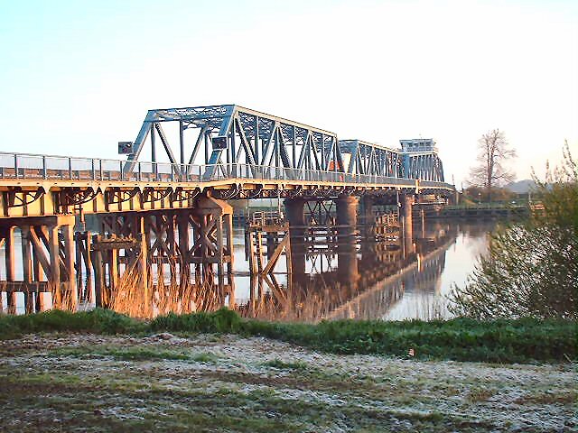
Boothferry Bridge

Boothferry Bridge is a crossing over the River Ouse, between the East Riding and West Yorkshire, England, some 2 miles (3.2 km) north-west of Goole. The...

Boothferry

Boothferry is a village in the East Riding of Yorkshire in England. It is situated on the north bank of the River Ouse where the A614 road crosses the...

Booth, East Riding of Yorkshire

Booth is a hamlet near Goole, in the East Riding of Yorkshire, England. Booth is also known as Boothferry or Boothferry Bridge. == References ==
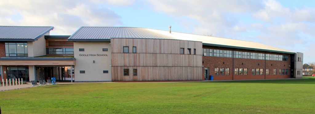
Goole Academy

Goole Academy, is a mixed 11–18 secondary school located in Goole, East Riding of Yorkshire, England. It is situated just off the A614 road in the east...
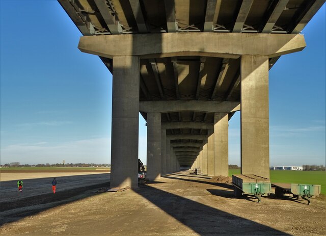
Ouse Bridge (M62)

The Ouse Bridge is a reinforced concrete plate girder bridge that spans River Ouse between Goole and Howden in the East Riding of Yorkshire, England. It...

Nearby Amenities

Located within 500m of 53.718979,-0.902809
Airmyn
Place: village
Lat/Long: 53.7182715/-0.9011218
Turning Circle
Lat/Long: 53.7176932/-0.8996663
Airmyn High Street
Naptan AtcoCode: 2200YEA11671
Naptan Bearing: S
Naptan BusStopType: CUS
Naptan CommonName: Airmyn High Street
Naptan Landmark: Post Office
Naptan Street: High Street
Naptan Verified: no
Source: naptan_import
Lat/Long: 53.7197183/-0.9025875
Airmyn High Street
Naptan AtcoCode: 2200YEZ01349
Naptan Bearing: N
Naptan BusStopType: CUS
Naptan CommonName: Airmyn High Street
Naptan Landmark: Post Office
Naptan Street: High Street
Naptan Verified: no
Source: naptan_import
Lat/Long: 53.719705/-0.9027856
Post Box
Lat/Long: 53.7197/-0.9026158
Barrier: kissing_gate
Foot: yes
Lat/Long: 53.7216428/-0.9029799
Airmyn Garage
Addr City: Goole
Addr Housenumber: 73
Addr Postcode: DN14 8LD
Addr Street: High Street
Addr Suburb: Airmyn
Shop: car_repair
Lat/Long: 53.7188047/-0.9027161
Man Made: tower
Tower Construction: freestanding
Tower Type: bell_tower
Lat/Long: 53.7211942/-0.9027651
Barrier: yes
Foot: yes
Lat/Long: 53.7201915/-0.8989162
Post Office
Airmyn Post Office
Addr City: Goole
Addr Country: GB
Addr Housename: Airmyn Village Hall
Addr Postcode: DN14 8LY
Addr Street: Off Woodland Way
Addr Suburb: Airmyn
Brand: Post Office
Brand Wikidata: Q1783168
Check Date: 2022-05-27
Check Date Opening Hours: 2022-05-27
Contact Website: https://www.postoffice.co.uk/branch-finder/1624709/airmyn
Opening Hours: Tu 14:00-16:00
Ref Pol Id: 93747
Lat/Long: 53.7183998/-0.8968753
The data included in this document is from www.openstreetmap.org. The data is made available under ODbL.

Have you been to Airmyn?

Leave your review of Airmyn below (or comments, questions and feedback).