Trallong

Settlement in Brecknockshire

Wales

Trallong

Comin uwchben Trallwng / Common above Trallong Tir comin ar dir uchel uwchben pentre Trallwng.

Upland common above Trallong village (trans. muddy area)
Comin uwchben Trallwng / Common above Trallong Credit: Alan Richards

Trallong is a small village located in the historic county of Brecknockshire, Wales. Nestled in the picturesque countryside of Powys, it is situated approximately 5 miles to the northeast of Brecon, the county town. Trallong covers an area of about 1 square mile and is home to a population of around 250 residents.

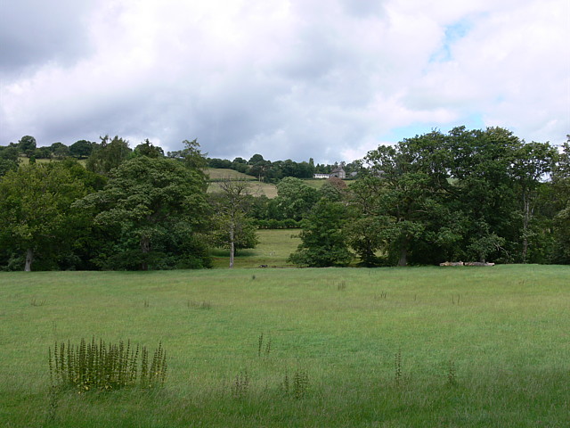
The village is surrounded by rolling hills and stunning natural landscapes, making it an ideal location for those seeking a peaceful and tranquil lifestyle. Trallong benefits from its close proximity to the Brecon Beacons National Park, which offers an abundance of outdoor activities including hiking, cycling, and wildlife spotting.

In terms of amenities, Trallong boasts a community hall which serves as a hub for local events and gatherings. There is also a primary school in the village, providing education for the younger residents. However, for more extensive amenities, the nearby town of Brecon offers a wider range of services including shops, supermarkets, and healthcare facilities.

Trallong has a rich history, with evidence of human habitation dating back to the Iron Age. The village features several historic buildings, such as St. David's Church, which dates back to the 13th century. The area also has links to the industrial revolution, with remnants of old tramways and quarries.

Overall, Trallong offers a charming and idyllic rural lifestyle, with its stunning natural surroundings and close-knit community. It is a place where residents can enjoy the beauty of the Welsh countryside while still having access to essential amenities.

If you have any feedback on the listing, please let us know in the comments section below.

Trallong Images

Images are sourced within 2km of 51.955417/-3.505714 or Grid Reference SN9629. Thanks to Geograph Open Source API. All images are credited.
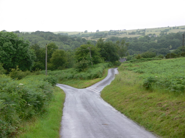
Comin uwchben Trallwng / Common above Trallong Tir comin ar dir uchel uwchben pentre Trallwng.

Upland common above Trallong village (trans. muddy area)
Comin uwchben Trallwng / Common above Trallong
Tir comin ar dir uchel uwchben pentre Trallwng. Upland common above Trallong village (trans. muddy area)
Comin uwchben Trallwng / Common above Trallong Llwybr ar tir comin yn mynd i lawr y waered i gyfeiriad pentre Trallwng.

A path on common land descends the hill towards Trallong village (trans. muddy area).
Comin uwchben Trallwng / Common above Trallong
Llwybr ar tir comin yn mynd i lawr y waered i gyfeiriad pentre Trallwng. A path on common land descends the hill towards Trallong village (trans. muddy area).
Trac i Drallwng / Track to Trallong Hen heol, sy bellach yn llwybr cyhoeddus, yn mynd i lawr y waered i gyfeiriad pentre Trallwng.

An old road, downgraded to a path,  descends towards the village of Trallong (trans. muddy area).
Trac i Drallwng / Track to Trallong
Hen heol, sy bellach yn llwybr cyhoeddus, yn mynd i lawr y waered i gyfeiriad pentre Trallwng. An old road, downgraded to a path, descends towards the village of Trallong (trans. muddy area).
Heol fach wledig / A minor rural road Heol fach wledig yn mynd i gyfeiriad Aberbran. Y ddwy gopa yn y pellter yw Pen y Fan a Chorn. Du.  Hen enw  arnynt oedd Cadair Arthur.

A minor rural road heading towards Aberbran (trans. confluence of the river Brân [crow]). The twin peaks in the distance are Pen y Fan and Corn Du.  An old name for the peaks is Cadair Arthur (trans. Arthur's Chair).
Heol fach wledig / A minor rural road
Heol fach wledig yn mynd i gyfeiriad Aberbran. Y ddwy gopa yn y pellter yw Pen y Fan a Chorn. Du. Hen enw arnynt oedd Cadair Arthur. A minor rural road heading towards Aberbran (trans. confluence of the river Brân [crow]). The twin peaks in the distance are Pen y Fan and Corn Du. An old name for the peaks is Cadair Arthur (trans. Arthur's Chair).
Road to Llanfihangel Nant Bran Great care needed by all in this section of bending narrow road with no viewing over the tall hedging
Road to Llanfihangel Nant Bran
Great care needed by all in this section of bending narrow road with no viewing over the tall hedging
Traditional road sign, Brecon County I love these old road signs such as this one on a road junction to the west of Trallong in the Usk valley.
Traditional road sign, Brecon County
I love these old road signs such as this one on a road junction to the west of Trallong in the Usk valley.
Road junction on Trallong Common I love these old road signs such as this one on a road junction on Trallong Common to the west of Trallong in the Usk valley.
Road junction on Trallong Common
I love these old road signs such as this one on a road junction on Trallong Common to the west of Trallong in the Usk valley.
Road to the A40 Country road to the A40 near Trallong Common, The Black Mountain, part of the Brecon Beacons National Park forms the backdrop.
Road to the A40
Country road to the A40 near Trallong Common, The Black Mountain, part of the Brecon Beacons National Park forms the backdrop.
Road across Trallong Common Country road crossing Trallong Common.
Road across Trallong Common
Country road crossing Trallong Common.
Road to Bryn y Fedwen Farm Road to Bryn y Fedwen Farm, as can be seen from the sign the farm offers Bed and Breakfast.
Road to Bryn y Fedwen Farm
Road to Bryn y Fedwen Farm, as can be seen from the sign the farm offers Bed and Breakfast.
Road junction on Trallong Common
Minor road across Trallong Common
From Brecon to Trecastle The old road from Brecon to Trecastell on the north side of the River Usk.

Note the old, cast-iron road sign, sadly damaged since <a href="https://www.geograph.org.uk/photo/3459539">SN9530 : Road junction on Trallong Common</a>. The left turning leads over the Usk to the A40.
From Brecon to Trecastle
The old road from Brecon to Trecastell on the north side of the River Usk. Note the old, cast-iron road sign, sadly damaged since SN9530 : Road junction on Trallong Common. The left turning leads over the Usk to the A40.
Plains at the top of a hill This fairly barren area is at the top of a hill.
Plains at the top of a hill
This fairly barren area is at the top of a hill.
The fork for Wernfigin on the road to Pentre'r-felin The wood in the background is Coed Mawr.
The fork for Wernfigin on the road to Pentre'r-felin
The wood in the background is Coed Mawr.
Road junction on Trallong Common Early post-war (WW2) cast iron direction sign
Road junction on Trallong Common
Early post-war (WW2) cast iron direction sign
West of Aberyscir, near Brecon From near Cusop, overlooking Pontarfran and the Usk Valley.
West of Aberyscir, near Brecon
From near Cusop, overlooking Pontarfran and the Usk Valley.
View across the Usk Valley towards the Brecon Beacons From Glifach uchaf.
View across the Usk Valley towards the Brecon Beacons
From Glifach uchaf.
Show me another place!

Trallong is located at Grid Ref: SN9629 (Lat: 51.955417, Lng: -3.505714)

Unitary Authority: Powys

Police Authority: Dyfed Powys

Also known as: Y Trallwng

What 3 Words

///caves.prop.existence. Near Brecon, Powys

Related Wikis

Trallong

Trallong (Welsh: Y Trallwng) is a village and community in Powys, Wales, in the historic county of Brecknockshire. == Description == The community of Trallong...

Abercamlais railway station

Abercamlais railway station was a private platform serving the Abercamlais estate in the traditional county of Brecknockshire, Wales. == History == Opened...

Abercamlais

Abercamlais is a Grade I listed country house in the Usk valley between Brecon and Sennybridge in Powys, Wales. Possibly dating back to the Middle Ages...

Penpont Manor House

Penpont is a seventeenth-century Grade I listed manor house in the Usk valley between Brecon and Sennybridge in Powys, Wales. It was built by Daniel Williams...

Nearby Amenities

Located within 500m of 51.955417,-3.505714
Bus Stop
Trallong
Lat/Long: 51.9555002/-3.5056861
Trallong
Place: hamlet
Source: NLS-OS-1st_Series
Lat/Long: 51.9545755/-3.5059792
Abercamlais
Historic Railway: station
Railway: site
Wikidata: Q4666794
Wikipedia: en:Abercamlais railway station
Lat/Long: 51.9520407/-3.5088697
Direction: 170
Generator Method: photovoltaic
Generator Output Electricity: yes
Generator Solar Modules: 12
Generator Source: solar
Generator Type: solar_photovoltaic_panel
Location: roof
Power: generator
Lat/Long: 51.9556991/-3.4997208
Telephone
Booth: K6
Covered: booth
Operator: BT
Phone: +44 1874 636545
Lat/Long: 51.9550693/-3.5067866
Post Box
Post Box Type: wall
Royal Cypher: GR
Royal Cypher Wikidata: Q33102273
Lat/Long: 51.954877/-3.5075117
The data included in this document is from www.openstreetmap.org. The data is made available under ODbL.

Have you been to Trallong?

Leave your review of Trallong below (or comments, questions and feedback).