Bosoughan

Settlement in Cornwall

England

Bosoughan

Restormel : The A392 The A392 in Restormel near White Cross. Some people are counting cars near the road junction.
Restormel : The A392 Credit: Lewis Clarke

Bosoughan is a small hamlet located in the county of Cornwall, England. Situated in the southwestern part of the country, Bosoughan is nestled amidst the picturesque countryside, offering visitors a tranquil and idyllic retreat. The hamlet is located approximately 3 miles northeast of the town of St. Columb Major and is easily accessible by road.

Although Bosoughan is a relatively small settlement, it boasts a rich history that dates back centuries. The architecture in the area reflects its heritage, with charming stone cottages and traditional buildings that have stood the test of time. The surrounding landscape is characterized by rolling hills, lush green fields, and meandering country lanes, providing a stunning backdrop for leisurely walks and exploration.

Nature lovers will find Bosoughan to be a haven, as it is surrounded by several natural attractions. The nearby Goss Moor Nature Reserve is a popular spot for birdwatching and offers a variety of walking trails through its diverse habitats. Additionally, the hamlet is within close proximity to the stunning sandy beaches and rugged cliffs that Cornwall is renowned for.

While Bosoughan may not have its own amenities, the nearby town of St. Columb Major provides residents and visitors with a range of services, including shops, restaurants, and leisure facilities. The hamlet's peaceful and rural setting is perfect for those seeking a slower pace of life or a base from which to explore the wider region of Cornwall.

If you have any feedback on the listing, please let us know in the comments section below.
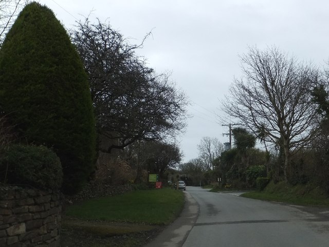
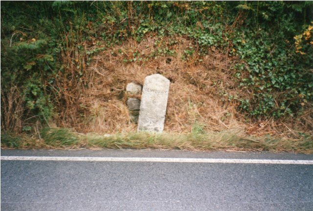
Bosoughan Images

Images are sourced within 2km of 50.409059/-4.987229 or Grid Reference SW8760. Thanks to Geograph Open Source API. All images are credited.

Restormel : The A392 The A392 in Restormel near White Cross. Some people are counting cars near the road junction.
Restormel : The A392
The A392 in Restormel near White Cross. Some people are counting cars near the road junction.
White Cross and a holiday camp White Acres is a large holiday camp with lodges and static caravans.  Most of the accommodation is on the right of the road, but there are about a dozen units in a plot on the left.  The picture shows one of the entrances
White Cross and a holiday camp
White Acres is a large holiday camp with lodges and static caravans. Most of the accommodation is on the right of the road, but there are about a dozen units in a plot on the left. The picture shows one of the entrances
A392 and railway bridge at White Cross
Luke's Shop Luke's Shop is a scattering of houses near a road junction.  The tree stands beside the road to the west
Luke's Shop
Luke's Shop is a scattering of houses near a road junction. The tree stands beside the road to the west
Bridge over unnamed stream west of Luke's Shop
Field and view nr Coswarth A view across the field with the clay spoil tip clearly seen on the horizon. Fradon village can be also seen across the valley.
Field and view nr Coswarth
A view across the field with the clay spoil tip clearly seen on the horizon. Fradon village can be also seen across the valley.
Cornish Lane nr Luke Shop The Windfarm can be seen on the hill in the distance.The lower verge has been recently been mown.
Cornish Lane nr Luke Shop
The Windfarm can be seen on the hill in the distance.The lower verge has been recently been mown.
Luke Shop lane looking towards White Cross
Mountjoy Ford This ford and impressive bridge are found at Mountjoy near Coswarth.
Mountjoy Ford
This ford and impressive bridge are found at Mountjoy near Coswarth.
Trebudannon Ford This impressive ford is found at Trebudannon
Trebudannon Ford
This impressive ford is found at Trebudannon
Bluebell lined road to Trevithick Looking eastward.
Bluebell lined road to Trevithick
Looking eastward.
Old Milestone at Trevithick, St Columb Major Carved stone post by the UC road, in parish of ST COLUMB MAJOR (RESTORMEL District), South West of Trevithick Pond, on junction at Trevithick, by the road, on South side of road. Erected by the Local Highways Board in the 19th century. 

Inscription reads:-
: THE FIR H(ILL) / 1½ / COLAN / 2 : : ST COLUMB / 2 : 

Grade II Listed. List Entry Number: 1395361
<span class="nowrap"><a title="https://historicengland.org.uk/listing/the-list/list-entry/1395361" rel="nofollow ugc noopener" href="https://historicengland.org.uk/listing/the-list/list-entry/1395361">Link</a><img style="margin-left:2px;" alt="External link" title="External link - shift click to open in new window" src="https://s1.geograph.org.uk/img/external.png" width="10" height="10"/></span>

Milestone Society National ID: CW_SCFH02.
Old Milestone at Trevithick, St Columb Major
Carved stone post by the UC road, in parish of ST COLUMB MAJOR (RESTORMEL District), South West of Trevithick Pond, on junction at Trevithick, by the road, on South side of road. Erected by the Local Highways Board in the 19th century. Inscription reads:- : THE FIR H(ILL) / 1½ / COLAN / 2 : : ST COLUMB / 2 : Grade II Listed. List Entry Number: 1395361 LinkExternal link Milestone Society National ID: CW_SCFH02.
Old Milestone east of Bosoughan Carved stone post by the UC road, in parish of COLAN (RESTORMEL District), Bosoughan, Colan side of Tregoose turn, by the road, on South side of road.   Erected by the Local Highways Board in the 19th century. 

Inscription reads:-
: THE FIR / HILL / 1½ : : ST / COLUMB / 3 :   

Grade II Listed. List Entry Number: 1312429
<span class="nowrap"><a title="https://historicengland.org.uk/listing/the-list/list-entry/1312429" rel="nofollow ugc noopener" href="https://historicengland.org.uk/listing/the-list/list-entry/1312429">Link</a><img style="margin-left:2px;" alt="External link" title="External link - shift click to open in new window" src="https://s1.geograph.org.uk/img/external.png" width="10" height="10"/></span>

Milestone Society National ID: CW_SCFH03.
Old Milestone east of Bosoughan
Carved stone post by the UC road, in parish of COLAN (RESTORMEL District), Bosoughan, Colan side of Tregoose turn, by the road, on South side of road. Erected by the Local Highways Board in the 19th century. Inscription reads:- : THE FIR / HILL / 1½ : : ST / COLUMB / 3 : Grade II Listed. List Entry Number: 1312429 LinkExternal link Milestone Society National ID: CW_SCFH03.
Old Milestone by the A392 in Mountjoy Carved stone post by the A392, in parish of COLAN (RESTORMEL District), Mountjoy, on the corner by cottage, on North side of road. Erected by the Local Highways Board in the 19th century. 

Inscription reads:-
: ST / COLUMB / 4 / COLAN / CHURCH / 1 / FIR / HILL / 1½ : : 18 / 52 : : QUEENS / 3¼ / ST / MICHAEL / 4¼ / TRURO / 11¼ : 
Carved benchmark on lower left face.

Grade II Listed. List Entry Number: 1144178
<span class="nowrap"><a title="https://historicengland.org.uk/listing/the-list/list-entry/1144178" rel="nofollow ugc noopener" href="https://historicengland.org.uk/listing/the-list/list-entry/1144178">Link</a><img style="margin-left:2px;" alt="External link" title="External link - shift click to open in new window" src="https://s1.geograph.org.uk/img/external.png" width="10" height="10"/></span>

Milestone Society National ID: CW_SCFH04.
Old Milestone by the A392 in Mountjoy
Carved stone post by the A392, in parish of COLAN (RESTORMEL District), Mountjoy, on the corner by cottage, on North side of road. Erected by the Local Highways Board in the 19th century. Inscription reads:- : ST / COLUMB / 4 / COLAN / CHURCH / 1 / FIR / HILL / 1½ : : 18 / 52 : : QUEENS / 3¼ / ST / MICHAEL / 4¼ / TRURO / 11¼ : Carved benchmark on lower left face. Grade II Listed. List Entry Number: 1144178 LinkExternal link Milestone Society National ID: CW_SCFH04.
Old Milestone, South of Trebudannon The milestone is located 15m along the lane to Trebudannon from the White Cross to St Columb road, in the hedge on the South West side of road. Parish of St Columb Major (Restormel District). Carved stone post, erected by the Local  Highways Board in the 19th century. 

Inscription reads:-
: COLAN / 2 : : ST / COLUMB / 2 :  

Grade II Listed. List Entry Number: 1395362
<span class="nowrap"><a title="https://historicengland.org.uk/listing/the-list/list-entry/1395362" rel="nofollow ugc noopener" href="https://historicengland.org.uk/listing/the-list/list-entry/1395362">Link</a><img style="margin-left:2px;" alt="External link" title="External link - shift click to open in new window" src="https://s1.geograph.org.uk/img/external.png" width="10" height="10"/></span>

Milestone Society National ID: CW_SCMJ02
Old Milestone, South of Trebudannon
The milestone is located 15m along the lane to Trebudannon from the White Cross to St Columb road, in the hedge on the South West side of road. Parish of St Columb Major (Restormel District). Carved stone post, erected by the Local Highways Board in the 19th century. Inscription reads:- : COLAN / 2 : : ST / COLUMB / 2 : Grade II Listed. List Entry Number: 1395362 LinkExternal link Milestone Society National ID: CW_SCMJ02
Old Milestone by the A392, east of White Cross, St Enoder Parish The milestone is located east of White Cross, on the shallow verge on the south side of the road. Parish of St Enoder (Restormel District). Carved stone post, erected by the Local Highways Board in the 19th century. 

Inscription reads:-
NEWQUAY
6 
Carved benchmark on front face.

Grade II listed. List Entry Number: 1395364
<span class="nowrap"><a title="https://historicengland.org.uk/listing/the-list/list-entry/1395364" rel="nofollow ugc noopener" href="https://historicengland.org.uk/listing/the-list/list-entry/1395364">Link</a><img style="margin-left:2px;" alt="External link" title="External link - shift click to open in new window" src="https://s1.geograph.org.uk/img/external.png" width="10" height="10"/></span>

Milestone Society National ID: CW_NQIQ06
Old Milestone by the A392, east of White Cross, St Enoder Parish
The milestone is located east of White Cross, on the shallow verge on the south side of the road. Parish of St Enoder (Restormel District). Carved stone post, erected by the Local Highways Board in the 19th century. Inscription reads:- NEWQUAY 6 Carved benchmark on front face. Grade II listed. List Entry Number: 1395364 LinkExternal link Milestone Society National ID: CW_NQIQ06
Old Guide Stone below redundant postbox, St Columb Major parish Stone by wall, by the UC road, in parish of St Columb Major (Restormel District), Post box (redundant) and direction stone, by the road. Opposite another postbox, which is still in use.

Inscription reads:-
TREBUDANNON
{<-arrow}

Cornwall & Scilly HER.
HER Number: MCO55785 <span class="nowrap"><a title="https://www.heritagegateway.org.uk/Gateway/Results_Single.aspx?uid=MCO55785&resourceID=1020" rel="nofollow ugc noopener" href="https://www.heritagegateway.org.uk/Gateway/Results_Single.aspx?uid=MCO55785&resourceID=1020">Link</a><img style="margin-left:2px;" alt="External link" title="External link - shift click to open in new window" src="https://s1.geograph.org.uk/img/external.png" width="10" height="10"/></span>

Surveyed

Milestone Society National ID: CW_XSTC5
Old Guide Stone below redundant postbox, St Columb Major parish
Stone by wall, by the UC road, in parish of St Columb Major (Restormel District), Post box (redundant) and direction stone, by the road. Opposite another postbox, which is still in use. Inscription reads:- TREBUDANNON {<-arrow} Cornwall & Scilly HER. HER Number: MCO55785 LinkExternal link Surveyed Milestone Society National ID: CW_XSTC5
Old Milestone by the A392, east of Mountjoy, Colan parish Carved stone post by the A392, in parish of COLAN (RESTORMEL District), E of Mountjoy, at top of hill by farm track, by the road, on South side of road.   Erected by the Local Highways Board in the 19th century. 

Inscription reads:-
NEWQUAY
5
Carved benchmark and rivet on top.

Grade II listed.  
List Entry Number: 1395365 &lt;span class=&quot;nowrap&quot;&gt;&lt;a title=&quot;https://historicengland.org.uk/listing/the-list/list-entry/1395365&quot; rel=&quot;nofollow ugc noopener&quot; href=&quot;https://historicengland.org.uk/listing/the-list/list-entry/1395365&quot;&gt;Link&lt;/a&gt;&lt;img style=&quot;margin-left:2px;&quot; alt=&quot;External link&quot; title=&quot;External link - shift click to open in new window&quot; src=&quot;https://s1.geograph.org.uk/img/external.png&quot; width=&quot;10&quot; height=&quot;10&quot;/&gt;&lt;/span&gt;

Milestone Society National ID: CW_NQIQ05.
Old Milestone by the A392, east of Mountjoy, Colan parish
Carved stone post by the A392, in parish of COLAN (RESTORMEL District), E of Mountjoy, at top of hill by farm track, by the road, on South side of road. Erected by the Local Highways Board in the 19th century. Inscription reads:- NEWQUAY 5 Carved benchmark and rivet on top. Grade II listed. List Entry Number: 1395365 LinkExternal link Milestone Society National ID: CW_NQIQ05.
Show me another place!

Bosoughan is located at Grid Ref: SW8760 (Lat: 50.409059, Lng: -4.987229)

Unitary Authority: Cornwall

Police Authority: Devon and Cornwall

What 3 Words

///replayed.velocity.unveils. Near St Columb Major, Cornwall

Nearby Locations

Mountjoy Bosoughan

Related Wikis

Bosoughan

Bosoughan is a village in Cornwall, England, United Kingdom, approximately three miles (5 km) east of Newquay. According to the Post Office the population...

Mountjoy, Cornwall

Mountjoy is a hamlet in the civil parish of Colan in Cornwall, England. It is on the A392 road, east of Quintrell Downs. == References ==

Colan, Cornwall

Colan (Cornish: Kolan) is a village and civil parish in mid-Cornwall, England, United Kingdom. It is situated approximately three miles (5 km) east of...

St Colanus' Church, Colan

Colan Church also known as St Colan Church is a 13th-century church in Colan, mid-Cornwall, UK. Dedicated to St Colanus, it became a Grade I listed building...

Nearby Amenities

Located within 500m of 50.409059,-4.987229
Tourism: camp_site
Lat/Long: 50.4100576/-4.9915904
The data included in this document is from www.openstreetmap.org. The data is made available under ODbL.

Have you been to Bosoughan?

Leave your review of Bosoughan below (or comments, questions and feedback).