Bosporthennis

Settlement in Cornwall

England

Bosporthennis

The buildings at Bosporthennis These are no longer completely abandoned (see: <a title="https://www.geograph.org.uk/photo/71726)," href="https://www.geograph.org.uk/photo/71726),">Link</a> but have been restored as a holiday home. So just abandoned for the majority of the year.
The buildings at Bosporthennis Credit: David Medcalf

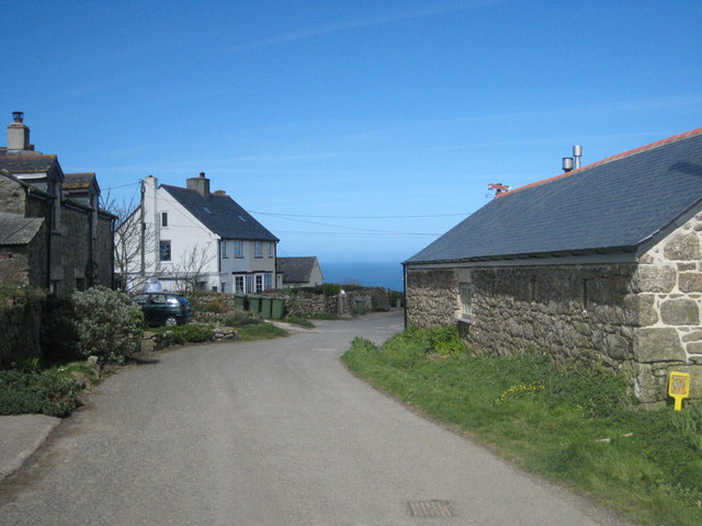
Bosporthennis is a small village located on the southern coast of Cornwall, England. Situated in the Penwith peninsula, it is known for its picturesque landscapes and stunning views of the Atlantic Ocean. The village is nestled between the popular tourist destinations of St Ives and Land's End, making it an ideal location for those seeking a peaceful and tranquil getaway.

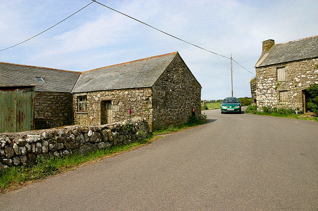
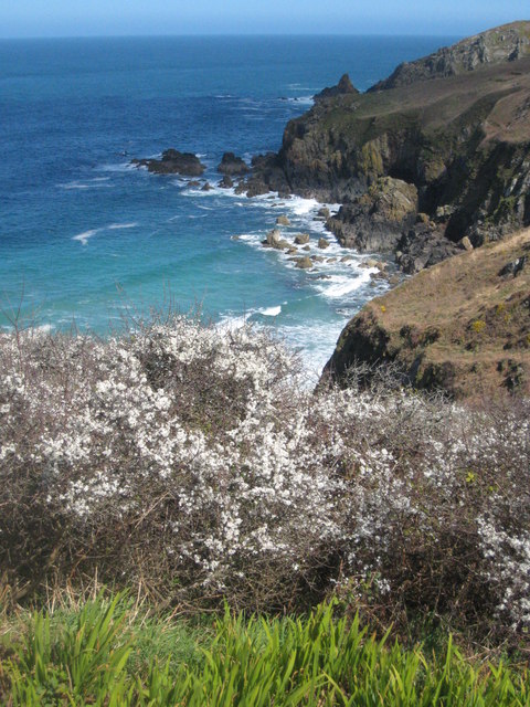
Bosporthennis is surrounded by rolling hills and rugged cliffs, providing ample opportunities for hiking and exploration. The coastal path that runs through the village offers breathtaking vistas of the sea and the surrounding countryside. The village itself consists of a handful of charming cottages and a local pub that serves traditional Cornish cuisine.

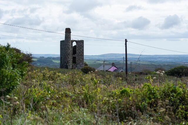
The area is rich in history, with several ancient sites nearby. Boscawen-Un, a well-preserved stone circle dating back to the Bronze Age, is just a short distance from the village. Visitors can also explore the remains of ancient tin mines, a testament to Cornwall's mining heritage.

For beach lovers, Bosporthennis offers easy access to some of Cornwall's most beautiful stretches of sand. Porthcurno and Sennen Cove, both renowned for their crystal-clear waters and golden sands, are within a short drive from the village.

Overall, Bosporthennis is a hidden gem in Cornwall, offering visitors a chance to experience the natural beauty and tranquility of the region. Whether it's exploring ancient sites, enjoying coastal walks, or simply relaxing on the beach, this idyllic village has something to offer for everyone.

If you have any feedback on the listing, please let us know in the comments section below.

Bosporthennis Images

Images are sourced within 2km of 50.172561/-5.58738 or Grid Reference SW4336. Thanks to Geograph Open Source API. All images are credited.

The buildings at Bosporthennis These are no longer completely abandoned (see: <a title="https://www.geograph.org.uk/photo/71726)," href="https://www.geograph.org.uk/photo/71726),">Link</a> but have been restored as a holiday home. So just abandoned for the majority of the year.
The buildings at Bosporthennis
These are no longer completely abandoned (see: Link but have been restored as a holiday home. So just abandoned for the majority of the year.
Ding Dong mines in Penwith
Path near Bosigran, with Can Galver Engine House in the distance
Porthmeor Cove from the South West Coast Path
Stone Stile SW4236a Cattle stile with granite block balanced on two blocks and one granite step each side; next to gate, probably originally a field stile. Footpath on National Trust land from B3306 to Bosigran cliff castle and SW coast path. On open land. First stile on this footpath north of the B3306 and Carn Galver 
Within farmland from the Porthmeor Stream to Porthmoina Stream.
Photo by Dr Charlotte MacKenzie
Stone Stile SW4236a
Cattle stile with granite block balanced on two blocks and one granite step each side; next to gate, probably originally a field stile. Footpath on National Trust land from B3306 to Bosigran cliff castle and SW coast path. On open land. First stile on this footpath north of the B3306 and Carn Galver Within farmland from the Porthmeor Stream to Porthmoina Stream. Photo by Dr Charlotte MacKenzie
Stone Stile SW4236a Cattle stile with granite block balanced on two blocks and one granite step each side; next to gate, probably originally a field stile. Footpath on National Trust land from B3306 to Bosigran cliff castle and SW coast path.  On open land. First stile on this footpath north of the B3306 and Carn Galver. Within farmland from the Porthmeor Stream to Porthmoina Stream.
Stone Stile SW4236a
Cattle stile with granite block balanced on two blocks and one granite step each side; next to gate, probably originally a field stile. Footpath on National Trust land from B3306 to Bosigran cliff castle and SW coast path. On open land. First stile on this footpath north of the B3306 and Carn Galver. Within farmland from the Porthmeor Stream to Porthmoina Stream.
Stone Stile SW4236b On farm land north of B3306 and west of Bosigran farm buildings, next to farm gate on track between late prehistoric and medieval field boundaries at Bosigran. On public footpath 120/15/2 Gold. Cattle stile with granite block balanced on two blocks and one granite step each side; next to gate. Looking west.
Stone Stile SW4236b
On farm land north of B3306 and west of Bosigran farm buildings, next to farm gate on track between late prehistoric and medieval field boundaries at Bosigran. On public footpath 120/15/2 Gold. Cattle stile with granite block balanced on two blocks and one granite step each side; next to gate. Looking west.
Stone Stile SW4236b On farm land north of B3306 and west of Bosigran farm buildings, next to farm gate on track between late prehistoric and medieval field boundaries at Bosigran. On public footpath 120/15/2 Gold. Cattle stile with granite block balanced on two blocks and one granite step each side; next to gate. Looking east to Bosigran farmstead
Stone Stile SW4236b
On farm land north of B3306 and west of Bosigran farm buildings, next to farm gate on track between late prehistoric and medieval field boundaries at Bosigran. On public footpath 120/15/2 Gold. Cattle stile with granite block balanced on two blocks and one granite step each side; next to gate. Looking east to Bosigran farmstead
Stone Stile SW4237a Boundary from field into Bosigran farm buildings, on Bosigran farm land north of B3306, west of Porthmeor stream. Public footpath 120/15/1 and 120/14/3 Gold. Circa early C19. Dressed granite moorstone and granite rubble. Stepped cattle stile adjoining rubble-faced hedge. Parish: Zennor
HER Number: DCO11754  Grade II listed No. 1144347
Stone Stile SW4237a
Boundary from field into Bosigran farm buildings, on Bosigran farm land north of B3306, west of Porthmeor stream. Public footpath 120/15/1 and 120/14/3 Gold. Circa early C19. Dressed granite moorstone and granite rubble. Stepped cattle stile adjoining rubble-faced hedge. Parish: Zennor HER Number: DCO11754 Grade II listed No. 1144347
Stone Stile SW4237a Boundary from field into Bosigran farm buildings, on Bosigran farm land north of B3306, west of Porthmeor stream. Public footpath 120/15/1 and 120/14/3 Gold. Dressed granite moorstone and granite rubble. Stepped cattle stile adjoining rubble-faced hedge.
Parish: Zennor
HER Number: DCO11754  Grade II listed No. 1144347
Stone Stile SW4237a
Boundary from field into Bosigran farm buildings, on Bosigran farm land north of B3306, west of Porthmeor stream. Public footpath 120/15/1 and 120/14/3 Gold. Dressed granite moorstone and granite rubble. Stepped cattle stile adjoining rubble-faced hedge. Parish: Zennor HER Number: DCO11754 Grade II listed No. 1144347
Stone Stile SW4237b Three stone steps. At eastern end of enclosed track at Bosigran/Lower Porthmeor tin working site. The stile leads south from the enclosed lane, at right angles to a second stile which is on the main path running east. Path number 120/14 gold.
Parish: Zennor
HER Number: DCO11914  Grade II listed 1137458 ‘Aqueduct and Stiles’
Stone Stile SW4237b
Three stone steps. At eastern end of enclosed track at Bosigran/Lower Porthmeor tin working site. The stile leads south from the enclosed lane, at right angles to a second stile which is on the main path running east. Path number 120/14 gold. Parish: Zennor HER Number: DCO11914 Grade II listed 1137458 ‘Aqueduct and Stiles’
Stone Stile SW4237c Cattle stile with three large steps. Public footpath 120/14/3 gold & 120/14/2 silver from: Bosigran to: Lower Porthmeor. 
Parish: Zennor
HER Number: DCO11914  Grade II listed 1137458 ‘Aqueduct and Stiles’
Stone Stile SW4237c
Cattle stile with three large steps. Public footpath 120/14/3 gold & 120/14/2 silver from: Bosigran to: Lower Porthmeor. Parish: Zennor HER Number: DCO11914 Grade II listed 1137458 ‘Aqueduct and Stiles’
Stone Stile SW4237c Cattle stile with three large steps. Public footpath 120/14/3 gold & 120/14/2 silver from Bosigran to Lower Porthmeor. 
Parish: Zennor
HER Number: DCO11914  Grade II listed 1137458 ‘Aqueduct and Stiles’
Stone Stile SW4237c
Cattle stile with three large steps. Public footpath 120/14/3 gold & 120/14/2 silver from Bosigran to Lower Porthmeor. Parish: Zennor HER Number: DCO11914 Grade II listed 1137458 ‘Aqueduct and Stiles’
Stone Stile SW4237d Cattle stile with three large steps each side. At western end of enclosed track at Bosigran/Lower Porthmeor tin working site. Public footpath 120/14/3 gold 
Parish: Zennor
HER Number: DCO11914  Grade II listed 1137458 ‘Aqueduct and Stiles’
Stone Stile SW4237d
Cattle stile with three large steps each side. At western end of enclosed track at Bosigran/Lower Porthmeor tin working site. Public footpath 120/14/3 gold Parish: Zennor HER Number: DCO11914 Grade II listed 1137458 ‘Aqueduct and Stiles’
Footpath looking west near Captain's House in Portmeor
Stone Stile Sw4337a Zennor A cattle stile with two steps each side situated at the commencement of a footpath heading off the B3306. There is a small stream here. Public footpath 120/9/1 B3306 to Treen.
Stone Stile Sw4337a Zennor
A cattle stile with two steps each side situated at the commencement of a footpath heading off the B3306. There is a small stream here. Public footpath 120/9/1 B3306 to Treen.
Stone Stile SW4337a Zennor Cattle stile with two steps each side, situated at the commencement of a footpath heading off the B3306. There is a small stream here. Looking west, the yellow-painted Gurnard's Head inn can be seen, approximately a quarter of a mile away at Treen. Public footpath 120/9/1 B3306 to Treen
Stone Stile SW4337a Zennor
Cattle stile with two steps each side, situated at the commencement of a footpath heading off the B3306. There is a small stream here. Looking west, the yellow-painted Gurnard's Head inn can be seen, approximately a quarter of a mile away at Treen. Public footpath 120/9/1 B3306 to Treen
Show me another place!

Bosporthennis is located at Grid Ref: SW4336 (Lat: 50.172561, Lng: -5.58738)

Unitary Authority: Cornwall

Police Authority: Devon and Cornwall

What 3 Words

///hence.booklet.wanting. Near Penzance, Cornwall

Nearby Locations

Bosporthennis

Related Wikis

Bosporthennis

Bosporthennis (Cornish: Bosporthenys) is a hamlet south of Treen in the civil parish of Zennor on the Penwith peninsula in west Cornwall, England, United...

Porthmeor

Porthmeor (from Cornish: Porth Meur, meaning "large cove") is a hamlet that consists of two farms, Higher and Lower Porthmeor, in the parish of Zennor...

Boswednack

Boswednack is a hamlet in the parish of Zennor near the north coast of the Penwith peninsula in Cornwall, England, United Kingdom. It is located along...

Treen, Zennor

Treen (Cornish: Tredhin) is a hamlet in the parish of Zennor, on the north coast of the Penwith peninsula in Cornwall, England, United Kingdom. It lies...

Nearby Amenities

Located within 500m of 50.172561,-5.58738
Bosporthennis Sacred Well
Tourism: attraction
Lat/Long: 50.1713718/-5.5875953
Heritage: yes
Historic: archaeological_site
Wikidata: Q17644379
Lat/Long: 50.1689426/-5.5894554
Bosporthennis
Name Kw: Bosporthenys
Place: hamlet
Wikidata: Q11688673
Wikipedia: en:Bosporthennis
Lat/Long: 50.1727754/-5.5880767
Power: pole
Lat/Long: 50.1750481/-5.5924487
Power: pole
Lat/Long: 50.1743601/-5.5911264
Power: pole
Lat/Long: 50.1738533/-5.5902037
Power: pole
Lat/Long: 50.173265/-5.5890504
Power: pole
Lat/Long: 50.1726654/-5.587889
Power: pole
Lat/Long: 50.1720831/-5.5871044
Power: pole
Lat/Long: 50.1716467/-5.586509
Power: pole
Lat/Long: 50.170798/-5.5853274
Power: pole
Transformer: distribution
Lat/Long: 50.1699992/-5.5842465
Power: pole
Transformer: distribution
Lat/Long: 50.1756253/-5.5877227
Power: pole
Lat/Long: 50.1749536/-5.5886534
Power: pole
Lat/Long: 50.1744451/-5.5893829
The data included in this document is from www.openstreetmap.org. The data is made available under ODbL.

Have you been to Bosporthennis?

Leave your review of Bosporthennis below (or comments, questions and feedback).