Surfleet Seas End

Settlement in Lincolnshire South Holland

England

Surfleet Seas End

Scoldall Lane
Scoldall Lane Credit: Jonathan Thacker

Surfleet Seas End is a small village located in Lincolnshire, a county in the East Midlands region of England. Situated on the eastern coast of England, this rural settlement is nestled between the larger towns of Spalding and Boston. With a population of just over 500 residents, Surfleet Seas End is known for its peaceful and idyllic countryside setting.

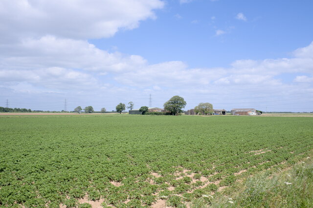
The village is characterized by its charming traditional cottages, picturesque farmlands, and scenic views of the River Glen. The surrounding landscape is predominantly agricultural, with vast fields of crops and grazing pastures for livestock. Agriculture plays a significant role in the local economy, with many residents employed in farming and related industries.

Despite its small size, Surfleet Seas End boasts a strong sense of community. The village has a primary school, a village hall, and a local pub, which serves as a social hub for residents and visitors alike. The close-knit community organizes various events and activities throughout the year, fostering a friendly and welcoming atmosphere.

For those seeking outdoor pursuits, Surfleet Seas End offers ample opportunities. The nearby River Glen provides a peaceful setting for fishing and boating enthusiasts, and the surrounding countryside is ideal for walking, cycling, and exploring nature.

In conclusion, Surfleet Seas End is a quiet and picturesque village in Lincolnshire, offering a serene countryside escape with a tight-knit community and plenty of outdoor recreational opportunities.

If you have any feedback on the listing, please let us know in the comments section below.

Surfleet Seas End Images

Images are sourced within 2km of 52.842036/-0.118816 or Grid Reference TF2628. Thanks to Geograph Open Source API. All images are credited.

Scoldall Lane
Scoldall Lane
Drain and wheat field off Peter Seadike Lane
Wheatfield off Peter Seadike Lane
Field recently planted with brassicas, Surfleet Marsh
Wheat field, Surfleet Marsh
Surfleet sea bank The road called "Surfleet Bank" is elevated because it largely follows an ancient sea bank that was important before the mechanical drainage of the Victorian era, and again in 1953.
Surfleet sea bank
The road called "Surfleet Bank" is elevated because it largely follows an ancient sea bank that was important before the mechanical drainage of the Victorian era, and again in 1953.
The old sea bank A portion, less elvated than the rest of it, of the old Surfleet Sea Bank.
The old sea bank
A portion, less elvated than the rest of it, of the old Surfleet Sea Bank.
Surfleet Bank Surfleet Bank is the name of a country lane that follows the erstwhile sea wall.
Surfleet Bank
Surfleet Bank is the name of a country lane that follows the erstwhile sea wall.
Field of Tatas Lincolnshire is a good place to grow potatoes, although some sort of problem has occurred along the edge of this field.  I imagine it was either too wet or too dry.
Field of Tatas
Lincolnshire is a good place to grow potatoes, although some sort of problem has occurred along the edge of this field. I imagine it was either too wet or too dry.
Lots of potatoes And, in the distance, a farm called Woad Farm.
Lots of potatoes
And, in the distance, a farm called Woad Farm.
Fenland crossroads, Surfleet, Lincs Belnie Lane from Gosberton meets Scoldhall Lane in the north of the parish and the south-east corner of the square.
Fenland crossroads, Surfleet, Lincs
Belnie Lane from Gosberton meets Scoldhall Lane in the north of the parish and the south-east corner of the square.
Burnt House, Peter Seadyke Lane, Surfleet, Lincs the only house in the square.
Burnt House, Peter Seadyke Lane, Surfleet, Lincs
the only house in the square.
Peter Seadyke Lane, Surfleet, Lincs meandering through the centre of the square – looking west.
Peter Seadyke Lane, Surfleet, Lincs
meandering through the centre of the square – looking west.
Peter Seadyke Lane, Surfleet, Lincs meandering through the centre of the square – looking east.
Peter Seadyke Lane, Surfleet, Lincs
meandering through the centre of the square – looking east.
Derelict agricultural holding, Surfleet, Lincs north of the Peter Seadyke Lane.
Derelict agricultural holding, Surfleet, Lincs
north of the Peter Seadyke Lane.
Woad Farm The brown vegetation in the field has been sprayed with sulphuric acid.
Mike Harrison later Emailed me (Jan 2008) with the following information:
"This is a field of potatoes with patches of annual sowthistles. Acid is used as the quickest,least damaging to the potato tubers, as it is not systemic and leaves no residues. Virtually withdrawn from use in 2008, due to crop growing protocols not allowing its use. The thistles are a late spring germinating weed and are not easily controlled with herbicides used on potatoes; they have become more prevalent in recent years all along the wash marshes."
Woad Farm
The brown vegetation in the field has been sprayed with sulphuric acid. Mike Harrison later Emailed me (Jan 2008) with the following information: "This is a field of potatoes with patches of annual sowthistles. Acid is used as the quickest,least damaging to the potato tubers, as it is not systemic and leaves no residues. Virtually withdrawn from use in 2008, due to crop growing protocols not allowing its use. The thistles are a late spring germinating weed and are not easily controlled with herbicides used on potatoes; they have become more prevalent in recent years all along the wash marshes."
Sods Lane
Sods Lane
Peter Seadike Lane
Peter Seadike Lane
Show me another place!

Surfleet Seas End is located at Grid Ref: TF2628 (Lat: 52.842036, Lng: -0.118816)

Division: Parts of Holland

Administrative County: Lincolnshire

District: South Holland

Police Authority: Lincolnshire

What 3 Words

///thrusters.charge.converter. Near Gosberton, Lincolnshire

Related Wikis

Surfleet railway station

Surfleet railway station was a station in Surfleet, Lincolnshire, England. It closed to passenger traffic on 11 September 1961. The rail line is now the...

Belnie

Belnie is a hamlet in the civil parish of Gosberton, Lincolnshire, England. == References ==

Surfleet

Surfleet is a small village and civil parish in the South Holland district of Lincolnshire, England. It is situated on the B1356 road, 3 miles (4.8 km...

Gosberton

Gosberton is a village and civil parish in the South Holland district of Lincolnshire, England. It is situated 9 miles (14.5 km) south-west of Boston,...

Nearby Amenities

Located within 500m of 52.842036,-0.118816
Bus Stop
Glen Gardens
Naptan AtcoCode: 270000009890
Naptan Bearing: E
Naptan CommonName: Glen Gardens
Naptan Indicator: adj
Naptan Landmark: Glen Gardens
Naptan NaptanCode: linjgdpa
Naptan Street: Station Road
Naptan Verified: no
Source: naptan_import
Lat/Long: 52.8422082/-0.1252718
Bus Stop
Glen Gardens
Naptan AtcoCode: 270000009891
Naptan Bearing: W
Naptan CommonName: Glen Gardens
Naptan Indicator: opp
Naptan Landmark: Glen Gardens
Naptan NaptanCode: linjgdpd
Naptan Street: Station Road
Naptan Verified: no
Source: naptan_import
Lat/Long: 52.842137/-0.1253194
Bus Stop
A16 Roundabout
Naptan AtcoCode: 270000009895
Naptan Bearing: NW
Naptan CommonName: A16 Roundabout
Naptan Indicator: NW - bound
Naptan Landmark: A16 Roundabout
Naptan NaptanCode: linjgdpt
Naptan Street: A152
Naptan Verified: no
Source: naptan_import
Lat/Long: 52.84547/-0.120602
Bus Stop
A16 Roundabout
Naptan AtcoCode: 270000009896
Naptan Bearing: SE
Naptan CommonName: A16 Roundabout
Naptan Indicator: SE - bound
Naptan Landmark: A16 Roundabout
Naptan NaptanCode: linjgdpw
Naptan Street: A152
Naptan Verified: no
Source: naptan_import
Lat/Long: 52.8455769/-0.1205379
Bus Stop
Riverside Hotel
Naptan AtcoCode: 2700LSSE4743
Naptan Bearing: NW
Naptan CommonName: Riverside Hotel
Naptan Landmark: Riverside Hotel
Naptan NaptanCode: lindmtpd
Naptan Street: Seas End Road
Naptan Verified: no
Source: naptan_import
Lat/Long: 52.841515/-0.1229407
Glen House Farm
Place: farm
Source: Bing
Lat/Long: 52.8412179/-0.1199989
Glen Rowan Farm
Place: farm
Source: Bing
Lat/Long: 52.842867/-0.1156956
Turning Circle
Lat/Long: 52.839938/-0.1235305
Traffic Calming: island
Lat/Long: 52.8412962/-0.1220836
Traffic Calming: island
Lat/Long: 52.8420211/-0.1221011
Barrier: kerb
Kerb: lowered
Tactile Paving: no
Lat/Long: 52.8412008/-0.1219109
Crossing
Tactile Paving: no
Lat/Long: 52.8412443/-0.1218834
Crossing
Lat/Long: 52.8415758/-0.122108
Post Box
Brand: Royal Mail
Brand Wikidata: Q638098
Collection Times: Mo-Fr 17:15; Sa 12:15
Drive Through: no
Operator: Royal Mail
Operator Wikidata: Q638098
Post Box Design: type_a
Post Box Type: pillar
Ref: PE11 22
Royal Cypher: EIIR
Royal Cypher Wikidata: Q33102113
Lat/Long: 52.8422512/-0.1254193
Post Office
Surfleet Post Office
Addr City: Spalding
Addr Country: GB
Addr Postcode: PE11 4DG
Addr Suburb: Surfleet
Brand: Post Office
Brand Wikidata: Q1783168
Contact Website: https://www.postoffice.co.uk/branch-finder/260230x/surfleet
Ref Pol Id: 10311
Lat/Long: 52.8423192/-0.1252275
Glenside Stores
Addr City: Spalding
Addr Country: GB
Addr Housenumber: 123
Addr Postcode: PE11 4DG
Addr Street: Station Road
Addr Suburb: Surfleet
Fhrs Authority: South Holland
Fhrs Id: 243000
Fhrs Local Authority Id: 4298
Opening Hours: Mo-Sa 07:00-19:00; Su 08:00-17:00
Shop: convenience
Lat/Long: 52.8422471/-0.1251913
Generator Method: photovoltaic
Generator Output Electricity: yes
Generator Source: solar
Generator Type: solar_photovoltaic_panel
Location: roof
Power: generator
Lat/Long: 52.8420512/-0.1258841
Generator Method: photovoltaic
Generator Output Electricity: yes
Generator Source: solar
Generator Type: solar_photovoltaic_panel
Location: roof
Power: generator
Lat/Long: 52.8420691/-0.1259981
Generator Method: photovoltaic
Generator Output Electricity: yes
Generator Source: solar
Generator Type: solar_photovoltaic_panel
Location: roof
Power: generator
Lat/Long: 52.8420423/-0.1260089
Generator Method: photovoltaic
Generator Output Electricity: yes
Generator Source: solar
Generator Type: solar_photovoltaic_panel
Location: roof
Power: generator
Lat/Long: 52.8428433/-0.1250406
Generator Method: photovoltaic
Generator Output Electricity: yes
Generator Source: solar
Generator Type: solar_photovoltaic_panel
Location: roof
Power: generator
Lat/Long: 52.8422309/-0.1246168
Generator Method: photovoltaic
Generator Output Electricity: yes
Generator Source: solar
Generator Type: solar_photovoltaic_panel
Location: roof
Power: generator
Lat/Long: 52.840559/-0.1177852
Generator Method: photovoltaic
Generator Output Electricity: yes
Generator Source: solar
Generator Type: solar_photovoltaic_panel
Location: roof
Power: generator
Lat/Long: 52.8407599/-0.1159801
Generator Method: photovoltaic
Generator Output Electricity: yes
Generator Source: solar
Generator Type: solar_photovoltaic_panel
Location: roof
Power: generator
Lat/Long: 52.8421694/-0.1137404
Surfleet
Historic Railway: station
Railway: site
Wikidata: Q7646138
Wikipedia: en:Surfleet railway station
Lat/Long: 52.8415503/-0.1221798
Waste Basket
Lat/Long: 52.8440792/-0.1132371
Shelter
Lat/Long: 52.8441283/-0.1131965
The data included in this document is from www.openstreetmap.org. The data is made available under ODbL.

Have you been to Surfleet Seas End?

Leave your review of Surfleet Seas End below (or comments, questions and feedback).