Bocking's Elm

Settlement in Essex Tendring

England

Bocking's Elm

St. John the Baptist church, Great Clacton, Essex It's hard to believe that before the Victorian era, Great Clacton was just a small village and Clacton-on-Sea would have been just farmland and perhaps the odd cottage. The whole of this area is now built up but you can pick out the original village buildings around the Norman church. The church was badly restored in 1865 but there is a lot of the old left to interest. The 15th century tower was never completed, hence the unusual timber structure on top.
St. John the Baptist church, Great Clacton, Essex Credit: Robert Edwards

Bocking's Elm is a small village located in the Braintree district of Essex, England. Situated approximately 50 miles northeast of London, it is nestled within the beautiful countryside of the county. The village takes its name from the ancient elm tree that once stood in the center of the settlement, providing a significant landmark and focal point for the community.

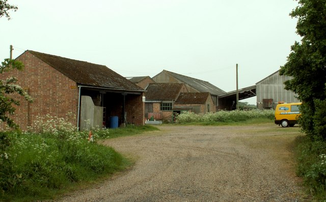
The village has a rich history that dates back centuries, with evidence of human habitation in the area during the Roman period. Throughout the medieval era, Bocking's Elm thrived as an agricultural community, with farming and the production of wool being the primary sources of income for its inhabitants.

Today, Bocking's Elm retains its rural charm and peaceful atmosphere. The village is known for its picturesque landscapes, featuring rolling hills, meandering streams, and traditional English cottages. The surrounding countryside offers opportunities for outdoor activities such as hiking, cycling, and horse riding.

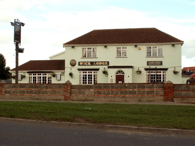
Although small in size, Bocking's Elm is well-served by a range of amenities, including a local pub, village hall, and a primary school. The village has good transport links, with easy access to nearby towns and cities, making it an attractive place to live for those seeking a quieter, more rural lifestyle while still being within commuting distance.

Overall, Bocking's Elm is a quaint and idyllic village that offers a peaceful retreat from the hustle and bustle of city life, showcasing the natural beauty and historical heritage of the Essex countryside.

If you have any feedback on the listing, please let us know in the comments section below.

Bocking's Elm Images

Images are sourced within 2km of 51.806224/1.129025 or Grid Reference TM1516. Thanks to Geograph Open Source API. All images are credited.

St. John the Baptist church, Great Clacton, Essex It's hard to believe that before the Victorian era, Great Clacton was just a small village and Clacton-on-Sea would have been just farmland and perhaps the odd cottage. The whole of this area is now built up but you can pick out the original village buildings around the Norman church. The church was badly restored in 1865 but there is a lot of the old left to interest. The 15th century tower was never completed, hence the unusual timber structure on top.
St. John the Baptist church, Great Clacton, Essex
It's hard to believe that before the Victorian era, Great Clacton was just a small village and Clacton-on-Sea would have been just farmland and perhaps the odd cottage. The whole of this area is now built up but you can pick out the original village buildings around the Norman church. The church was badly restored in 1865 but there is a lot of the old left to interest. The 15th century tower was never completed, hence the unusual timber structure on top.
Tesco, Brook Retail Park, Great Clacton, Essex
'Wick Lodge' public house, Jaywick, Essex
The A.133, leaving Clacton-on-Sea, Essex
Bovill's Hall This hall lies to the west of Little Clacton. The O/S map shows it as Bovill's Hall, not farm, even though the buildings that surround it give every indication that it is a farm.
Bovill's Hall
This hall lies to the west of Little Clacton. The O/S map shows it as Bovill's Hall, not farm, even though the buildings that surround it give every indication that it is a farm.
The road to Rouses Farm This is called Rouses Lane and only leads to the farm. Towards the end it forms part of a footpath.
The road to Rouses Farm
This is called Rouses Lane and only leads to the farm. Towards the end it forms part of a footpath.
Earls Hall Drive This is also a footpath that leads to Earls Hall.
Earls Hall Drive
This is also a footpath that leads to Earls Hall.
Part of Elm Farm, just west of Great Clacton
Dead Lane at Little Clacton This lane used to continue to Little Clacton, but it is now cut in half by the new A.133, just a little further on from the barrier.
Dead Lane at Little Clacton
This lane used to continue to Little Clacton, but it is now cut in half by the new A.133, just a little further on from the barrier.
A row of shops on Coppins Road
The B1027 at Great Clacton This view shows the direction to St Osyth.
The B1027 at Great Clacton
This view shows the direction to St Osyth.
A view of Tinker's Hall from Rush Green Road
Earls Hall Trig This is the Earls Hall triangulation pillar on the footpath from Earls Hall to Hartleywood farm
Earls Hall Trig
This is the Earls Hall triangulation pillar on the footpath from Earls Hall to Hartleywood farm
Earls Hall Mast A radio communications mast on Earls Hall Farm
Earls Hall Mast
A radio communications mast on Earls Hall Farm
Earls Hall Haystacks? In my book these are both haystacks even though the nearest pile of bales is made of <a href="https://www.geograph.org.uk/photo/538557">TM1416 : Straw</a> however do the bales of <a href="https://www.geograph.org.uk/photo/538560">TM1416 : Hay</a> actually constitute a stack and not just a pile of bales?
Earls Hall Haystacks?
In my book these are both haystacks even though the nearest pile of bales is made of TM1416 : Straw however do the bales of TM1416 : Hay actually constitute a stack and not just a pile of bales?
Straw Straw on Earls Hall Farm
Straw
Straw on Earls Hall Farm
Hay Hay on Earls Hall Farm
Hay
Hay on Earls Hall Farm
Innocent juxtaposition Two single-storey commercial buildings next to one another in Old Road. A strange combination!
Innocent juxtaposition
Two single-storey commercial buildings next to one another in Old Road. A strange combination!
Show me another place!

Bocking's Elm is located at Grid Ref: TM1516 (Lat: 51.806224, Lng: 1.129025)

Administrative County: Essex

District: Tendring

Police Authority: Essex

What 3 Words

///mats.cases.sport. Near Little Clacton, Essex

Related Wikis

Clacton County High School

Clacton County High School is a co-educational secondary school and sixth form with academy status, located in Clacton-on-Sea, in the county of Essex,...

Clacton Coastal Academy

Clacton Coastal Academy is a coeducational high school serving the western part of Clacton-on-Sea. The school has a population of about 1377 students with...

Little Clacton

Little Clacton is a village and civil parish in the Tendring district, in the county of Essex, England. It is located on the Tendring Peninsula, close...

F.C. Clacton

F.C. Clacton is a football club based in Clacton-on-Sea, Essex, England. The club are currently members of the Essex Senior League and play at the Rush...

Bocking's Elm

Bocking's Elm is a suburb of Clacton-on-Sea, in the Tendring district of Essex, England. == References == Essex A-Z (page 184)

Bishops Park College

Bishops Park College was a comprehensive school located in Clacton-on-Sea, Essex. It is now officially combined with Colbayns High School. The two have...

Tendring Enterprise Studio School

Tendring Enterprise Studio School was a 14–19 mixed, secondary studio school and sixth form in Clacton-on-Sea, Essex, England. It was established in 2012...

Clacton-on-Sea

Clacton-on-Sea, often simply called Clacton, is a seaside town and resort in the county of Essex, on the east coast of England. It is located on the Tendring...

Nearby Amenities

Located within 500m of 51.806224,1.129025
Crossing
Crossing Ref: zebra
Lat/Long: 51.8040326/1.1300287
Crossing
Crossing: traffic_signals
Crossing Ref: toucan
Lat/Long: 51.8062475/1.1271892
Mini Roundabout
Direction: clockwise
Lat/Long: 51.8040171/1.1305404
Mini Roundabout
Direction: clockwise
Lat/Long: 51.8065808/1.1271405
Mini Roundabout
Direction: clockwise
Lat/Long: 51.8044258/1.1355128
Bockings Elm
Place: locality
Lat/Long: 51.8040022/1.1304632
Post Box
Mapillary: 275094721301947
Post Box Type: pillar
Postal Code: CO16 8DU
Ref: CO16 9
Survey Date: 2021-12-03
Lat/Long: 51.8039388/1.129875
Post Box
Postal Code: CO16 8XF
Ref: CO16 197
Lat/Long: 51.8067153/1.1356481
Bus Stop
Waterworks Drive
Flag: no
Layby: yes
Naptan AtcoCode: 150032007041
Naptan Bearing: S
Naptan CommonName: Waterworks Drive
Naptan Crossing: Waterworks Drive
Naptan Indicator: Opp
Naptan Landmark: Waterworks Drive
Naptan NaptanCode: esxgmadm
Naptan PlusbusZoneRef: CLACTON
Naptan Street: Cloes Lane
Public Transport: platform
Source: naptan_import; survey
Lat/Long: 51.8034845/1.1305914
Bus Stop
Waterworks Drive
Flag: yes
Kerb: raised
Naptan AtcoCode: 150032007042
Naptan Bearing: N
Naptan BusStopType: CUS
Naptan CommonName: Waterworks Drive
Naptan Crossing: Waterworks Drive
Naptan Indicator: Adj
Naptan Landmark: Waterworks Drive
Naptan NaptanCode: esxgmadp
Naptan PlusbusZoneRef: CLACTON
Naptan Street: Cloes Lane
Public Transport: platform
Source: naptan_import; survey
Lat/Long: 51.8032599/1.1304189
Bus Stop
Purley Way
Naptan AtcoCode: 150044001003
Naptan Bearing: E
Naptan CommonName: Purley Way
Naptan Crossing: Purley Way
Naptan Indicator: Adj
Naptan Landmark: Purley Way
Naptan NaptanCode: esxajtjm
Naptan PlusbusZoneRef: CLACTON
Naptan Street: Constable Avenue
Naptan Verified: no
Public Transport: platform
Source: naptan_import
Lat/Long: 51.8066365/1.1273786
Bus Stop
Mayford Way
Naptan AtcoCode: 150044001004
Naptan NaptanCode: esxajtjp
Naptan PlusbusZoneRef: CLACTON
Naptan Verified: no
Public Transport: platform
Source: naptan_import
Lat/Long: 51.8073034/1.1298633
Purley Way
Naptan AtcoCode: 1500440010Y3
Naptan Bearing: W
Naptan BusStopType: CUS
Naptan CommonName: Purley Way
Naptan Crossing: Purley Way
Naptan Indicator: Opp
Naptan Landmark: Purley Way
Naptan NaptanCode: esxgwptw
Naptan PlusbusZoneRef: CLACTON
Naptan Street: Constable Avenue
Naptan Verified: no
Public Transport: platform
Source: naptan_import
Lat/Long: 51.8066107/1.12765
Mayford Way
Naptan AtcoCode: 1500440010Y4
Naptan BusStopType: CUS
Naptan NaptanCode: esxgwpwa
Naptan PlusbusZoneRef: CLACTON
Naptan Verified: no
Public Transport: platform
Source: naptan_import
Lat/Long: 51.807229/1.1301014
Bus Stop
Cottage Grove
Naptan AtcoCode: 150044002004
Naptan Bearing: E
Naptan CommonName: Cottage Grove
Naptan Crossing: Cottage Grove
Naptan Indicator: Adj
Naptan Landmark: Cottage Grove
Naptan NaptanCode: esxajpad
Naptan PlusbusZoneRef: CLACTON
Naptan Street: St. John's Road
Public Transport: platform
Route Ref: 18;602
Source: naptan_import; survey
Lat/Long: 51.804457/1.1346442
Bus Stop
Cottage Grove
Naptan AtcoCode: 150044002005
Naptan Bearing: W
Naptan CommonName: Cottage Grove
Naptan Crossing: Cottage Grove
Naptan Indicator: Opp
Naptan Landmark: Cottage Grove
Naptan NaptanCode: esxajpag
Naptan PlusbusZoneRef: CLACTON
Naptan Street: St. John's Road
Public Transport: platform
Source: naptan_import; survey
Lat/Long: 51.8041374/1.1337659
Bus Stop
Brace of Pistols
Naptan AtcoCode: 1500IM1283
Naptan Bearing: E
Naptan CommonName: Brace of Pistols
Naptan Indicator: o/s
Naptan Landmark: Brace of Pistols
Naptan NaptanCode: esxajpaj
Naptan PlusbusZoneRef: CLACTON
Naptan Street: St. John's Road
Public Transport: platform
Route Ref: 17;18;74;74B
Source: naptan_import; survey
Timetable Case: yes
Lat/Long: 51.8040411/1.1293526
Bus Stop
Brace of Pistols
Kerb: raised
Naptan AtcoCode: 1500IM1283B
Naptan Bearing: W
Naptan CommonName: Brace of Pistols
Naptan Indicator: Opp
Naptan Landmark: Brace of Pistols
Naptan NaptanCode: esxajpam
Naptan PlusbusZoneRef: CLACTON
Naptan Street: St. John's Road
Public Transport: platform
Route Ref: 74;74B;135;310
Source: naptan_import; survey
Timetable Case: yes
Lat/Long: 51.8038401/1.1284722
Bus Stop
Merstham Drive
Naptan AtcoCode: 1500IM245
Naptan Bearing: E
Naptan CommonName: Constable Avenue
Naptan Crossing: Merstham Drive
Naptan Indicator: E-bound
Naptan Landmark: Constable Avenue
Naptan NaptanCode: esxajmwg
Naptan PlusbusZoneRef: CLACTON
Naptan Street: Constable Avenue
Naptan Verified: no
Public Transport: platform
Source: naptan_import
Lat/Long: 51.8066932/1.1346781
Bus Stop
Merstham Drive
Naptan AtcoCode: 1500IM245AA
Naptan Bearing: W
Naptan BusStopType: CUS
Naptan CommonName: Constable Avenue
Naptan Crossing: Merstham Drive
Naptan Indicator: W-bound
Naptan Landmark: Constable Avenue
Naptan NaptanCode: esxgwmwp
Naptan PlusbusZoneRef: CLACTON
Naptan Street: Constable Avenue
Naptan Verified: no
Public Transport: platform
Source: naptan_import
Lat/Long: 51.8066424/1.1345585
Bus Stop
Dedham Avenue
Naptan AtcoCode: 1500IM89
Naptan Bearing: NE
Naptan CommonName: Dedham Avenue
Naptan Crossing: Dedham Avenue
Naptan Indicator: Opp
Naptan Landmark: Dedham Avenue
Naptan NaptanCode: esxadagt
Naptan PlusbusZoneRef: CLACTON
Naptan Street: Flatford Drive
Naptan Verified: no
Public Transport: platform
Source: naptan_import
Lat/Long: 51.8022089/1.1287958
Dedham Avenue
Naptan AtcoCode: 1500IM89Y
Naptan Bearing: SW
Naptan BusStopType: CUS
Naptan CommonName: Dedham Avenue
Naptan Crossing: Dedham Avenue
Naptan Indicator: Adj
Naptan Landmark: Dedham Avenue
Naptan NaptanCode: esxjagmd
Naptan PlusbusZoneRef: CLACTON
Naptan Status: ina
Naptan Street: Flatford Drive
Naptan Verified: no
Public Transport: platform
Source: naptan_import
Lat/Long: 51.8022699/1.1292063
Bus Stop
Little Clacton Road
Flag: no
Kerb: raised
Naptan AtcoCode: 1500LITCNRD
Naptan Bearing: S
Naptan BusStopType: CUS
Naptan CommonName: Little Clacton Road
Naptan Crossing: Bockings Grove
Naptan Indicator: S-bound
Naptan Landmark: Little Clacton Road
Naptan NaptanCode: esxajmwd
Naptan PlusbusZoneRef: CLACTON
Naptan Street: Little Clacton Road
Public Transport: platform
Source: naptan_import; survey
Lat/Long: 51.8044536/1.1275778
Bus Stop
Little Clacton Road
Flag: yes
Kerb: raised
Naptan AtcoCode: 1500LITCNYD
Naptan Bearing: N
Naptan BusStopType: CUS
Naptan CommonName: Little Clacton Road
Naptan Crossing: Bockings Grove
Naptan Indicator: N-bound
Naptan Landmark: Little Clacton Road
Naptan NaptanCode: esxgwmtw
Naptan PlusbusZoneRef: CLACTON
Naptan Street: Little Clacton Road
Public Transport: platform
Route Ref: 3;17
Source: naptan_import; survey
Lat/Long: 51.8044449/1.127441
Crossing
Crossing: zebra
Lat/Long: 51.8029356/1.1304326
Turning Circle
Lat/Long: 51.802528/1.1280679
Barrier: cycle_barrier
Lat/Long: 51.802836/1.1311922
Leisure: pitch
Sport: soccer
Lat/Long: 51.8060564/1.130038
Waste Basket
Waste: dog_excrement
Lat/Long: 51.8059121/1.1304067
Barrier: cycle_barrier
Lat/Long: 51.8059952/1.1294059
Barrier: bollard
Lat/Long: 51.806323/1.1315077
Mini Roundabout
Direction: clockwise
Lat/Long: 51.8070105/1.1270135
Power: pole
Source: bing
Lat/Long: 51.8054184/1.1224849
Power: pole
Source: bing
Lat/Long: 51.8062831/1.1231376
Power: pole
Source: bing
Lat/Long: 51.8070805/1.1237567
Power: pole
Source: bing
Lat/Long: 51.8078549/1.1243464
Power: pole
Source: bing
Lat/Long: 51.8086063/1.1251931
Power: pole
Source: bing
Lat/Long: 51.8093548/1.12596
Power: pole
Source: bing
Lat/Long: 51.810079/1.1264345
Atm
Fee: no
Lat/Long: 51.8041514/1.1305169
Noexit: yes
Lat/Long: 51.8058716/1.1271668
Atm
Lat/Long: 51.8031191/1.1240544
Bicycle Parking
Capacity: 6
Lat/Long: 51.803298/1.1242514
Bicycle Parking
Capacity: 12
Lat/Long: 51.8035083/1.123741
Entrance: main
Lat/Long: 51.8035015/1.1236175
Defibrillator
Access: yes
Defibrillator Location: On outside wall of Albert Edward Hall, next to main entrance
Emergency: defibrillator
Indoor: no
Lat/Long: 51.8035083/1.1235901
Bus Stop
Dresden Square
Naptan AtcoCode: 1500440091Y1
Naptan NaptanCode: esxjpjmj
Naptan Verified: no
Public Transport: platform
Source: naptan
Lat/Long: 51.8052007/1.1254042
Bus Stop
Grier Way
Naptan AtcoCode: 1500440091Y2
Naptan NaptanCode: esxjpjmt
Naptan Verified: no
Public Transport: platform
Source: naptan
Lat/Long: 51.806945/1.1265148
Bus Stop
Sainsbury's Local
Naptan AtcoCode: 1500HNR819
Naptan BusStopType: HAR
Naptan NaptanCode: esxjptwd
Naptan Status: ina
Naptan Verified: no
Public Transport: platform
Source: naptan
Lat/Long: 51.8032613/1.1236629
Bus Stop
Grier Way
Naptan AtcoCode: 150044009102
Naptan NaptanCode: esxjpjmp
Naptan Verified: no
Public Transport: platform
Source: naptan
Lat/Long: 51.8070098/1.1264468
Bus Stop
Dresden Square
Naptan AtcoCode: 150044009101
Naptan NaptanCode: esxjpjmg
Naptan Verified: no
Public Transport: platform
Source: naptan
Lat/Long: 51.8058017/1.124848
Entrance: main
Lat/Long: 51.8032653/1.1242546
The data included in this document is from www.openstreetmap.org. The data is made available under ODbL.

Have you been to Bocking's Elm?

Leave your review of Bocking's Elm below (or comments, questions and feedback).