South Aywick

Settlement in Shetland

Scotland

South Aywick

Ness of Queyon Taken on the B9081 as we pass through East Yell, Yell, Shetland, I am looking across Otters Wick to the Ness of Queyon, the croft of the same name and the Hill of Queyon. The cliffs of Hascosay and Mid Yell can be seen beyond.
Ness of Queyon Credit: Carroll Pierce

South Aywick is a small village located in the Shetland Islands, an archipelago in the North Atlantic Ocean. Specifically, it is situated on the mainland of Shetland, on the west coast of the island. With a population of around 150 residents, it is considered a tight-knit and close community.

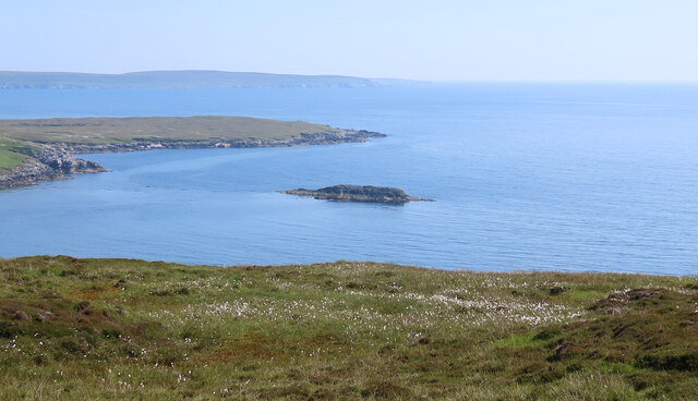
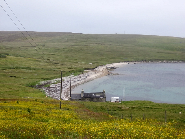
The village is known for its picturesque surroundings and breathtaking natural beauty. Surrounded by rolling hills and stunning cliffs, South Aywick offers panoramic views of the North Sea and the neighboring islands. Its coastal location makes it an ideal spot for birdwatching and wildlife enthusiasts, with various seabirds and seals frequently spotted in the area.

Despite its small size, South Aywick boasts a rich history. The village is home to several ancient archaeological sites, including Iron Age settlements and Viking remains. These historical artifacts provide insight into the island's past and offer visitors a chance to delve into its fascinating heritage.

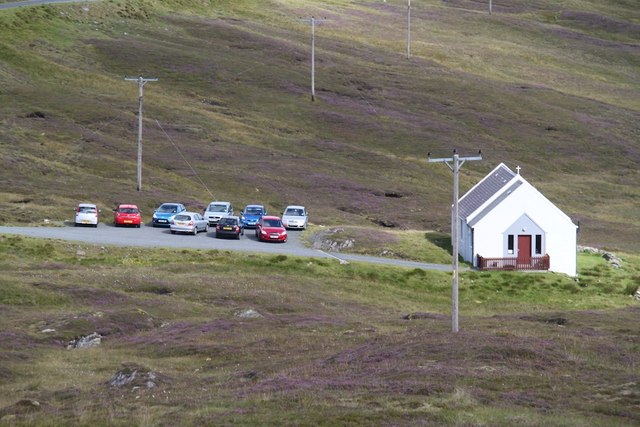
Although South Aywick is primarily a residential area, it does offer a few amenities for locals and visitors alike. There is a small convenience store and a community hall that serves as a hub for social events and gatherings. Additionally, the village is within a short driving distance of larger towns and villages, providing access to additional services and facilities.

Overall, South Aywick is a tranquil and picturesque village that encapsulates the natural beauty and rich history of the Shetland Islands. With its close-knit community and stunning surroundings, it is a haven for those seeking a peaceful and idyllic retreat.

If you have any feedback on the listing, please let us know in the comments section below.

South Aywick Images

Images are sourced within 2km of 60.55404/-1.0354309 or Grid Reference HU5386. Thanks to Geograph Open Source API. All images are credited.

Ness of Queyon Taken on the B9081 as we pass through East Yell, Yell, Shetland, I am looking across Otters Wick to the Ness of Queyon, the croft of the same name and the Hill of Queyon. The cliffs of Hascosay and Mid Yell can be seen beyond.
Ness of Queyon
Taken on the B9081 as we pass through East Yell, Yell, Shetland, I am looking across Otters Wick to the Ness of Queyon, the croft of the same name and the Hill of Queyon. The cliffs of Hascosay and Mid Yell can be seen beyond.
Black Skerry Taken on the B9081 as we pass through East Yell, Yell, Shetland, I am looking east across common cotton-grass and the water of Otters Wick to Black Skerry. The Ness of Queyon is to the left of shot in the middle distance with Mid Yell beyond.
Black Skerry
Taken on the B9081 as we pass through East Yell, Yell, Shetland, I am looking east across common cotton-grass and the water of Otters Wick to Black Skerry. The Ness of Queyon is to the left of shot in the middle distance with Mid Yell beyond.
East Yell: postbox № ZE2 59 A small postbox alongside a bus shelter at the junction, a short distance from the post office. The box is emptied at half past nine on weekday and Saturday mornigs.
East Yell: postbox № ZE2 59
A small postbox alongside a bus shelter at the junction, a short distance from the post office. The box is emptied at half past nine on weekday and Saturday mornigs.
East Yell: the White Wife This unusual monument commemorates a shipping disaster in April 1924. Setting sail from Gothenburg, bound for Chile, the 'Bohus' had been sailing for three days when a navigational error resulted in the ship becoming grounded a short distance from here, some 60 miles off her intended course. Within half an hour most of the ship had broken up.

Four of the 39 on board perished, and the survivors owed a lot to the men of Yell who acted swiftly when they saw the tragedy emerging.

The ship's figurehead was washed ashore in September 1924 and this is what we see here: erected by local people as a memorial to the tragedy, within sight of where it occurred.
East Yell: the White Wife
This unusual monument commemorates a shipping disaster in April 1924. Setting sail from Gothenburg, bound for Chile, the 'Bohus' had been sailing for three days when a navigational error resulted in the ship becoming grounded a short distance from here, some 60 miles off her intended course. Within half an hour most of the ship had broken up. Four of the 39 on board perished, and the survivors owed a lot to the men of Yell who acted swiftly when they saw the tragedy emerging. The ship's figurehead was washed ashore in September 1924 and this is what we see here: erected by local people as a memorial to the tragedy, within sight of where it occurred.
East Yell: the White Wife looks out Another view of <a href="https://www.geograph.org.uk/photo/2651277">HU5285 : East Yell: the White Wife</a>, from behind her as she looks out across Otters Wick. Black Skerry is the rock in the centre of the picture.

This unusual monument commemorates a shipping disaster in April 1924. Setting sail from Gothenburg, bound for Chile, the 'Bohus' had been sailing for three days when a navigational error resulted in the ship becoming grounded a short distance from here, some 60 miles off her intended course. Within half an hour most of the ship had broken up.

Four of the 39 on board perished, and the survivors owed a lot to the men of Yell who acted swiftly when they saw the tragedy emerging.

The ship's figurehead was washed ashore in September 1924 and this is what we see here: erected by local people as a memorial to the tragedy, within sight of where it occurred.
East Yell: the White Wife looks out
Another view of HU5285 : East Yell: the White Wife, from behind her as she looks out across Otters Wick. Black Skerry is the rock in the centre of the picture. This unusual monument commemorates a shipping disaster in April 1924. Setting sail from Gothenburg, bound for Chile, the 'Bohus' had been sailing for three days when a navigational error resulted in the ship becoming grounded a short distance from here, some 60 miles off her intended course. Within half an hour most of the ship had broken up. Four of the 39 on board perished, and the survivors owed a lot to the men of Yell who acted swiftly when they saw the tragedy emerging. The ship's figurehead was washed ashore in September 1924 and this is what we see here: erected by local people as a memorial to the tragedy, within sight of where it occurred.
East Yell: north edge of Otters Wick Looking down on the head of Otters Wick.
East Yell: north edge of Otters Wick
Looking down on the head of Otters Wick.
East Yell: the Methodist chapel A small chapel in the Otterswick area of East Yell.
East Yell: the Methodist chapel
A small chapel in the Otterswick area of East Yell.
Small Church A small church near Otterswick
Small Church
A small church near Otterswick
Otterswick: Burn of the Mires of Queyintiptins The course of this, surely one of the longest named streams, can be seen running across the picture left-to-right and then coming towards us into the North Burn of Otterswick, whose northern bank is more prominent across the bottom of the picture.
Otterswick: Burn of the Mires of Queyintiptins
The course of this, surely one of the longest named streams, can be seen running across the picture left-to-right and then coming towards us into the North Burn of Otterswick, whose northern bank is more prominent across the bottom of the picture.
B9081, Otterswick View of a bend in the road from the bogs. The East Yell Methodist Chapel is on the right.
B9081, Otterswick
View of a bend in the road from the bogs. The East Yell Methodist Chapel is on the right.
Heading Back To The Road Moorland view towards road with distant view of East Yell Methodist Chapel.
Heading Back To The Road
Moorland view towards road with distant view of East Yell Methodist Chapel.
Reused salmon cages Old salmon cage parts used as fencing, Otterwick.
Reused salmon cages
Old salmon cage parts used as fencing, Otterwick.
Otters Wick Beach at Otterswick.
Otters Wick
Beach at Otterswick.
East Yell Hall Community hall near Otterswick. The balers are lined up at an agricultural market.
East Yell Hall
Community hall near Otterswick. The balers are lined up at an agricultural market.
Parked boat, Otterswick
Mart, Corn Hill New pens at the sheep market by Otterswick.
Mart, Corn Hill
New pens at the sheep market by Otterswick.
Field, Otterswick A small enclosure won from the moors.
Field, Otterswick
A small enclosure won from the moors.
Hill of Holligarth Dryish moorland on terrain very much like high ground (>600m) in the central Highlands.
Hill of Holligarth
Dryish moorland on terrain very much like high ground (>600m) in the central Highlands.
Show me another place!

South Aywick is located at Grid Ref: HU5386 (Lat: 60.55404, Lng: -1.0354309)

Unitary Authority: Shetland Islands

Police Authority: Highlands and Islands

What 3 Words

///tops.brightens.fear. Near Ulsta, Shetland Islands

Related Wikis

Aywick

Aywick is a small settlement on the east side of Yell, an island forming part of the Shetland Islands north of Scotland.The naturalist Bobby Tulloch was...

Otterswick

Otterswick is a hamlet on the island of Yell in the Shetland Islands, on the inlet of Otters Wick. It is on the east side of the island. There is also...

Gossabrough

Gossabrough is a coastal hamlet, wick and ness on the southeast side of the island of Yell, Shetland, Scotland. The Wick of Gossabrough lies between the...

Mid Yell

Mid Yell is a coastal settlement on the island of Yell, the second largest of Shetland Islands, Scotland. Mid Yell, the largest settlement on the island...

Burravoe

Burravoe is a community on the north shore of Burra Voe, in the south-east part of the island of Yell in the Shetland Islands, Scotland. The name Burravoe...

Burra Voe

Burra Voe (Old Norse: Borgavagr, Broch Bay) is sheltered bay (voe) at the southeast corner of the island of Yell. The village of Burravoe (HU525795) is...

Old Haa Museum

The Old Haa of Brough in located in Burravoe, Yell, Shetland, Scotland. Built for Robert Tyrie, a merchant, in 1672, houses the local museum for Burravoe...

Hascosay

Hascosay (Scots: Hascosay; Old Norse "Hafskotsey") is a small island lying between Yell and Fetlar in the Shetland Islands, Scotland. == Geography and... ==

Nearby Amenities

Located within 500m of 60.55404,-1.0354309
Man Made: survey_point
Lat/Long: 60.55649/-1.0330931
Power: pole
Lat/Long: 60.55017/-1.0394362
Power: pole
Lat/Long: 60.5504819/-1.0384383
Power: pole
Lat/Long: 60.5507666/-1.0375457
Power: pole
Lat/Long: 60.5511229/-1.0364551
Power: pole
Lat/Long: 60.5515173/-1.0352591
Power: pole
Lat/Long: 60.5519217/-1.034028
Power: pole
Lat/Long: 60.5522274/-1.0330577
Power: pole
Lat/Long: 60.5527451/-1.0321726
Power: pole
Lat/Long: 60.5532616/-1.03127
Power: pole
Lat/Long: 60.5537632/-1.0303849
Power: pole
Lat/Long: 60.5541885/-1.0296352
Power: pole
Lat/Long: 60.5546038/-1.0289031
Power: pole
Lat/Long: 60.5550587/-1.0281108
Power: pole
Lat/Long: 60.555527/-1.0272959
Power: pole
Lat/Long: 60.549773/-1.0379695
Power: pole
Lat/Long: 60.5503943/-1.0403113
Power: pole
Lat/Long: 60.5506545/-1.0412891
The data included in this document is from www.openstreetmap.org. The data is made available under ODbL.

Have you been to South Aywick?

Leave your review of South Aywick below (or comments, questions and feedback).