The Helliack

Coastal Feature, Headland, Point in Shetland

Scotland

The Helliack

Ness of Queyon Taken on the B9081 as we pass through East Yell, Yell, Shetland, I am looking across Otters Wick to the Ness of Queyon, the croft of the same name and the Hill of Queyon. The cliffs of Hascosay and Mid Yell can be seen beyond.
Ness of Queyon Credit: Carroll Pierce

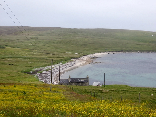
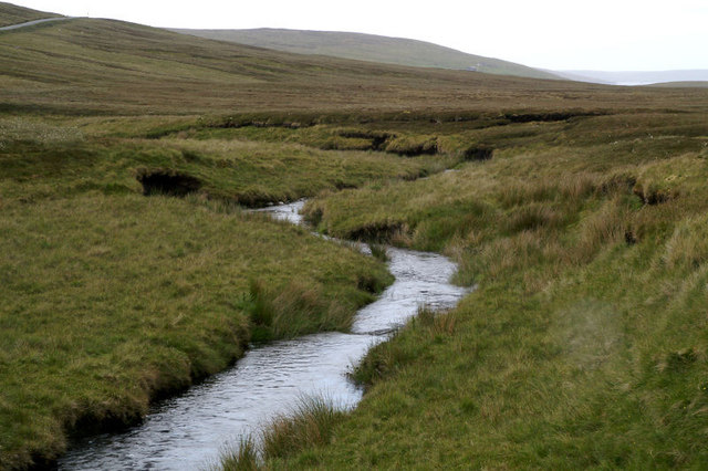
The Helliack is a prominent coastal feature located in the Shetland Islands, off the northeastern coast of Scotland. It is a headland or point that juts out into the North Sea, forming a distinctive landmark along the rugged coastline of Shetland. The Helliack is known for its dramatic cliffs, which tower above the crashing waves below.

Rising to an elevation of approximately 50 meters (164 feet), the Helliack offers breathtaking panoramic views of the surrounding area. The headland is composed of layered rocks, showcasing the geological history of the region. The cliffs themselves are a result of the continuous erosion by the sea over millions of years, creating stunning formations and natural arches that add to the area's allure.

The Helliack is also a popular spot for birdwatching enthusiasts, as the cliffs provide nesting sites for a variety of seabirds, including puffins, guillemots, and razorbills. Visitors can often witness these colorful birds soaring above the waves or perched on the rocky ledges.

Access to the Helliack is relatively easy, with a well-maintained footpath leading to the headland from nearby coastal villages. The area is frequented by hikers, photographers, and nature lovers seeking to experience the raw beauty of Shetland's coastline.

Overall, the Helliack is an exceptional coastal feature that showcases the ruggedness and natural splendor of the Shetland Islands. It offers visitors a chance to immerse themselves in the stunning landscapes, observe diverse wildlife, and appreciate the power of nature's forces at work.

If you have any feedback on the listing, please let us know in the comments section below.

The Helliack Images

Images are sourced within 2km of 60.557199/-1.0191427 or Grid Reference HU5386. Thanks to Geograph Open Source API. All images are credited.
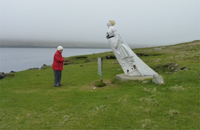
Ness of Queyon Taken on the B9081 as we pass through East Yell, Yell, Shetland, I am looking across Otters Wick to the Ness of Queyon, the croft of the same name and the Hill of Queyon. The cliffs of Hascosay and Mid Yell can be seen beyond.
Ness of Queyon
Taken on the B9081 as we pass through East Yell, Yell, Shetland, I am looking across Otters Wick to the Ness of Queyon, the croft of the same name and the Hill of Queyon. The cliffs of Hascosay and Mid Yell can be seen beyond.
East Yell: postbox № ZE2 59 A small postbox alongside a bus shelter at the junction, a short distance from the post office. The box is emptied at half past nine on weekday and Saturday mornigs.
East Yell: postbox № ZE2 59
A small postbox alongside a bus shelter at the junction, a short distance from the post office. The box is emptied at half past nine on weekday and Saturday mornigs.
East Yell: the White Wife This unusual monument commemorates a shipping disaster in April 1924. Setting sail from Gothenburg, bound for Chile, the 'Bohus' had been sailing for three days when a navigational error resulted in the ship becoming grounded a short distance from here, some 60 miles off her intended course. Within half an hour most of the ship had broken up.

Four of the 39 on board perished, and the survivors owed a lot to the men of Yell who acted swiftly when they saw the tragedy emerging.

The ship's figurehead was washed ashore in September 1924 and this is what we see here: erected by local people as a memorial to the tragedy, within sight of where it occurred.
East Yell: the White Wife
This unusual monument commemorates a shipping disaster in April 1924. Setting sail from Gothenburg, bound for Chile, the 'Bohus' had been sailing for three days when a navigational error resulted in the ship becoming grounded a short distance from here, some 60 miles off her intended course. Within half an hour most of the ship had broken up. Four of the 39 on board perished, and the survivors owed a lot to the men of Yell who acted swiftly when they saw the tragedy emerging. The ship's figurehead was washed ashore in September 1924 and this is what we see here: erected by local people as a memorial to the tragedy, within sight of where it occurred.
East Yell: the White Wife looks out Another view of <a href="https://www.geograph.org.uk/photo/2651277">HU5285 : East Yell: the White Wife</a>, from behind her as she looks out across Otters Wick. Black Skerry is the rock in the centre of the picture.

This unusual monument commemorates a shipping disaster in April 1924. Setting sail from Gothenburg, bound for Chile, the 'Bohus' had been sailing for three days when a navigational error resulted in the ship becoming grounded a short distance from here, some 60 miles off her intended course. Within half an hour most of the ship had broken up.

Four of the 39 on board perished, and the survivors owed a lot to the men of Yell who acted swiftly when they saw the tragedy emerging.

The ship's figurehead was washed ashore in September 1924 and this is what we see here: erected by local people as a memorial to the tragedy, within sight of where it occurred.
East Yell: the White Wife looks out
Another view of HU5285 : East Yell: the White Wife, from behind her as she looks out across Otters Wick. Black Skerry is the rock in the centre of the picture. This unusual monument commemorates a shipping disaster in April 1924. Setting sail from Gothenburg, bound for Chile, the 'Bohus' had been sailing for three days when a navigational error resulted in the ship becoming grounded a short distance from here, some 60 miles off her intended course. Within half an hour most of the ship had broken up. Four of the 39 on board perished, and the survivors owed a lot to the men of Yell who acted swiftly when they saw the tragedy emerging. The ship's figurehead was washed ashore in September 1924 and this is what we see here: erected by local people as a memorial to the tragedy, within sight of where it occurred.
East Yell: north edge of Otters Wick Looking down on the head of Otters Wick.
East Yell: north edge of Otters Wick
Looking down on the head of Otters Wick.
Otterswick: Burn of the Mires of Queyintiptins The course of this, surely one of the longest named streams, can be seen running across the picture left-to-right and then coming towards us into the North Burn of Otterswick, whose northern bank is more prominent across the bottom of the picture.
Otterswick: Burn of the Mires of Queyintiptins
The course of this, surely one of the longest named streams, can be seen running across the picture left-to-right and then coming towards us into the North Burn of Otterswick, whose northern bank is more prominent across the bottom of the picture.
Reused salmon cages Old salmon cage parts used as fencing, Otterwick.
Reused salmon cages
Old salmon cage parts used as fencing, Otterwick.
Otters Wick Beach at Otterswick.
Otters Wick
Beach at Otterswick.
East Yell Hall Community hall near Otterswick. The balers are lined up at an agricultural market.
East Yell Hall
Community hall near Otterswick. The balers are lined up at an agricultural market.
Parked boat, Otterswick
Mart, Corn Hill New pens at the sheep market by Otterswick.
Mart, Corn Hill
New pens at the sheep market by Otterswick.
Lady in red studies White Wife The story of how the 'White Wife' (aka 'Wudden Wife') ship's figurehead came to be at Otterswick is told here <a href="https://www.geograph.org.uk/photo/1453591">HU5285 : The White Wife: an explanation</a>.
Lady in red studies White Wife
The story of how the 'White Wife' (aka 'Wudden Wife') ship's figurehead came to be at Otterswick is told here HU5285 : The White Wife: an explanation.
Stone walls and fishing nets With the Black Skerry rock in Otters Wick in the background.
Stone walls and fishing nets
With the Black Skerry rock in Otters Wick in the background.
White Wife View of the Hill of Queyon, with the 'White Wife' (an old ship's figurehead rescued from a wreck) on the near shore.  The bay in the foreground is Otters Wick, the island of Fetlar is in the background.  View from the hill above Otterswick village.
White Wife
View of the Hill of Queyon, with the 'White Wife' (an old ship's figurehead rescued from a wreck) on the near shore. The bay in the foreground is Otters Wick, the island of Fetlar is in the background. View from the hill above Otterswick village.
White Wife, Yell, Shetland The figurehead of the German barque, Bohus, which ran aground in 1924
White Wife, Yell, Shetland
The figurehead of the German barque, Bohus, which ran aground in 1924
Figurehead of the "White Wife" According to local tradition (and thus published many times) The White Wife (or White Lady) of Otterswick is said to be a German lady. 

According to her life records we have to say that Bertha is a British girl or more correctly a Scottish girl, "born in Grangemouth of German parents". 

She was the figurehead of the steel barque Bertha built in 1892 by Grangemouth Dockyard Co., Grangemouth, as yard no. 163. Her dimensions were: 74,11×11,70×6,88 metres [248'2"×38'4"×22'4"] and with a tonnage of 1653 GRT (1499 NRT and 2600 DWT). She was launched at the shipyard of Grangemouth Dockyard Co. for Joh. H. Soost, Hamburg on July 6th, 1892 and assigned the official German signal RJQD. 

She was named after Bertha, the eldest daughter of Joh. H. Soost, and this should be the proper name of The White Lady. 

In 1899 she was sold to Captain M. Dietrich, Hamburg, and thereafter changed hands several times. In her great days until 1912 she did a lot of long distance runs such as 1904 from Lizard Point to Seattle in 154 days, 1906 from Lizard Point to Sydney in 117 days and again in 1909 in 114 days or in 1910 from Sydney to Falmouth f/o in 129 days. 

In 1912 she was sold to Sweden changed hands several times and ended up with Förnyade Ångfartygs AB Viking, Gothenburg, for SEK 500.000. She was then renamed Bohus and assigned the official Swedish Reg. No. 5903 and signal KBCV. Captain at that time was Mr Ragnar Erik Nyberg, Stockholm. Bertha was bound to the Baltic Sea, mostly sailing in Swedish and Finnish waters.
Figurehead of the "White Wife"
According to local tradition (and thus published many times) The White Wife (or White Lady) of Otterswick is said to be a German lady. According to her life records we have to say that Bertha is a British girl or more correctly a Scottish girl, "born in Grangemouth of German parents". She was the figurehead of the steel barque Bertha built in 1892 by Grangemouth Dockyard Co., Grangemouth, as yard no. 163. Her dimensions were: 74,11×11,70×6,88 metres [248'2"×38'4"×22'4"] and with a tonnage of 1653 GRT (1499 NRT and 2600 DWT). She was launched at the shipyard of Grangemouth Dockyard Co. for Joh. H. Soost, Hamburg on July 6th, 1892 and assigned the official German signal RJQD. She was named after Bertha, the eldest daughter of Joh. H. Soost, and this should be the proper name of The White Lady. In 1899 she was sold to Captain M. Dietrich, Hamburg, and thereafter changed hands several times. In her great days until 1912 she did a lot of long distance runs such as 1904 from Lizard Point to Seattle in 154 days, 1906 from Lizard Point to Sydney in 117 days and again in 1909 in 114 days or in 1910 from Sydney to Falmouth f/o in 129 days. In 1912 she was sold to Sweden changed hands several times and ended up with Förnyade Ångfartygs AB Viking, Gothenburg, for SEK 500.000. She was then renamed Bohus and assigned the official Swedish Reg. No. 5903 and signal KBCV. Captain at that time was Mr Ragnar Erik Nyberg, Stockholm. Bertha was bound to the Baltic Sea, mostly sailing in Swedish and Finnish waters.
Hogalee Burn The burn rises on the hill of Hoga Lee and flows into the Loch of Vatsetter but, like several other Shetland burns, it has several names along the way.
Hogalee Burn
The burn rises on the hill of Hoga Lee and flows into the Loch of Vatsetter but, like several other Shetland burns, it has several names along the way.
Moorhouse, North Aywick
Show me another place!

The Helliack is located at Grid Ref: HU5386 (Lat: 60.557199, Lng: -1.0191427)

Unitary Authority: Shetland Islands

Police Authority: Highlands and Islands

What 3 Words

///lists.rant.lawyer. Near Ulsta, Shetland Islands

Related Wikis

Aywick

Aywick is a small settlement on the east side of Yell, an island forming part of the Shetland Islands north of Scotland.The naturalist Bobby Tulloch was...

Otterswick

Otterswick is a hamlet on the island of Yell in the Shetland Islands, on the inlet of Otters Wick. It is on the east side of the island. There is also...

Gossabrough

Gossabrough is a coastal hamlet, wick and ness on the southeast side of the island of Yell, Shetland, Scotland. The Wick of Gossabrough lies between the...

Mid Yell

Mid Yell is a coastal settlement on the island of Yell, the second largest of Shetland Islands, Scotland. Mid Yell, the largest settlement on the island...

Burra Voe

Burra Voe (Old Norse: Borgavagr, Broch Bay) is sheltered bay (voe) at the southeast corner of the island of Yell. The village of Burravoe (HU525795) is...

Burravoe

Burravoe is a community on the north shore of Burra Voe, in the south-east part of the island of Yell in the Shetland Islands, Scotland. The name Burravoe...

Hascosay

Hascosay (Scots: Hascosay; Old Norse "Hafskotsey") is a small island lying between Yell and Fetlar in the Shetland Islands, Scotland. == Geography and... ==

Old Haa Museum

The Old Haa of Brough in located in Burravoe, Yell, Shetland, Scotland. Built for Robert Tyrie, a merchant, in 1672, houses the local museum for Burravoe...

Nearby Amenities

Located within 500m of 60.557199,-1.0191427
Barrier: cattle_grid
Lat/Long: 60.5594786/-1.0261284
Power: pole
Lat/Long: 60.5599833/-1.0236154
Power: pole
Lat/Long: 60.555527/-1.0272959
Power: pole
Lat/Long: 60.5559818/-1.0264961
Power: pole
Lat/Long: 60.5564058/-1.0257339
Power: pole
Lat/Long: 60.5569074/-1.0248639
Power: pole
Lat/Long: 60.5573635/-1.024069
Power: pole
Lat/Long: 60.5578614/-1.0231965
Power: pole
Lat/Long: 60.5582447/-1.0225195
Power: pole
Lat/Long: 60.5586427/-1.0218125
Power: pole
Lat/Long: 60.5590174/-1.022324
Power: pole
Lat/Long: 60.5595214/-1.0229909
Power: pole
Lat/Long: 60.5606195/-1.0244727
The data included in this document is from www.openstreetmap.org. The data is made available under ODbL.

Have you been to The Helliack?

Leave your review of The Helliack below (or comments, questions and feedback).