Shrewton
Settlement in Wiltshire
England
Shrewton
![Orcheston houses [1] Threepenny Bit is a detached cottage built in the late 17th century with a20th century rear extension. Constructed of cob and chalk under a thatch half-hipped roof. Some original internal features and fittings remain. Listed, grade II, with details at: <span class="nowrap"><a title="https://historicengland.org.uk/listing/the-list/list-entry/1023988" rel="nofollow ugc noopener" href="https://historicengland.org.uk/listing/the-list/list-entry/1023988">Link</a><img style="margin-left:2px;" alt="External link" title="External link - shift click to open in new window" src="https://s1.geograph.org.uk/img/external.png" width="10" height="10"/></span>
The small village of Orcheston lies on Salisbury Plain about a mile northwest of Shrewton and some 6¼ miles west of Durrington. Salisbury plain has been inhabited since prehistoric times, and Orcheston is recorded in the 1086 Domesday Book. The source of the River Till is nearby. The village has two 13th century churches.](https://s2.geograph.org.uk/geophotos/07/37/82/7378266_5c64bae5.jpg)
Shrewton is a small village located in Wiltshire, England. Situated about 12 miles west of Salisbury, it is nestled in the picturesque landscape of the Salisbury Plain. With a population of around 2,000 residents, Shrewton has a close-knit and friendly community.
The village has a rich history, dating back to ancient times. Evidence of human settlement in the area can be traced as far back as the Neolithic period, with numerous archaeological sites and burial mounds found nearby. In recent years, the discovery of the famous Stonehenge monument just a few miles away has further enhanced the historical significance of the region.
Shrewton offers a range of amenities for its residents and visitors. The village has a primary school, a post office, a convenience store, and a pub. It also has a community center that hosts various events and activities throughout the year. The surrounding countryside provides ample opportunities for outdoor enthusiasts, with walking and cycling trails that showcase the natural beauty of the area.
Despite its small size, Shrewton is well-connected to neighboring towns and cities. The A303 road runs nearby, providing easy access to Salisbury, Andover, and the wider Wiltshire region. Additionally, the village has regular bus services, making it convenient for commuters and those looking to explore the surrounding areas.
Overall, Shrewton offers a peaceful and idyllic setting for residents and visitors alike, with its rich history, friendly community, and proximity to natural attractions making it an appealing place to live or visit in Wiltshire.
If you have any feedback on the listing, please let us know in the comments section below.
Shrewton Images
Images are sourced within 2km of 51.194036/-1.9038 or Grid Reference SU0643. Thanks to Geograph Open Source API. All images are credited.
![Orcheston houses [2] Green Willows is a detached cottage built in the early 18th century with a 20th century extension. The original construction is of cob and flint under a thatch roof, the extension is of brick with a slate roof. Listed, grade II, with details at: <span class="nowrap"><a title="https://historicengland.org.uk/listing/the-list/list-entry/1181858" rel="nofollow ugc noopener" href="https://historicengland.org.uk/listing/the-list/list-entry/1181858">Link</a><img style="margin-left:2px;" alt="External link" title="External link - shift click to open in new window" src="https://s1.geograph.org.uk/img/external.png" width="10" height="10"/></span>
The small village of Orcheston lies on Salisbury Plain about a mile northwest of Shrewton and some 6¼ miles west of Durrington. Salisbury plain has been inhabited since prehistoric times, and Orcheston is recorded in the 1086 Domesday Book. The source of the River Till is nearby. The village has two 13th century churches.](https://s3.geograph.org.uk/geophotos/07/37/82/7378267_a87426e9.jpg)
![Orcheston buildings [1] Now a private house, The Old School House was built in 1854. It became a National School in 1871 and closed in 1932. Constructed of brick and flint under a tile roof.
The small village of Orcheston lies on Salisbury Plain about a mile northwest of Shrewton and some 6¼ miles west of Durrington. Salisbury plain has been inhabited since prehistoric times, and Orcheston is recorded in the 1086 Domesday Book. The source of the River Till is nearby. The village has two 13th century churches.](https://s0.geograph.org.uk/geophotos/07/37/82/7378268_a2c4790a.jpg)
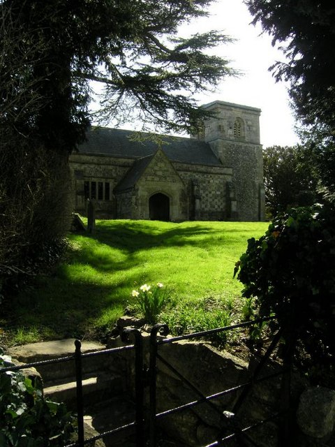
![Parish church [5] Part of the churchyard.
The Anglican parish church of St Mary was built in the mid 13th century. The tower was added circa 1300, and the chancel in the 16th century. There was a major restoration in 1833 when the chancel was rebuilt and the south porch added. Constructed of flint and limestone under Welsh slate roofs. Listed, grade II*, with details at: <span class="nowrap"><a title="https://historicengland.org.uk/listing/the-list/list-entry/1181876" rel="nofollow ugc noopener" href="https://historicengland.org.uk/listing/the-list/list-entry/1181876">Link</a><img style="margin-left:2px;" alt="External link" title="External link - shift click to open in new window" src="https://s1.geograph.org.uk/img/external.png" width="10" height="10"/></span>
The small village of Orcheston lies on Salisbury Plain about a mile northwest of Shrewton and some 6¼ miles west of Durrington. Salisbury plain has been inhabited since prehistoric times, and Orcheston is recorded in the 1086 Domesday Book. The source of the River Till is nearby. The village has two 13th century churches.](https://s1.geograph.org.uk/geophotos/07/37/82/7378273_ca1c33bf.jpg)
![Parish church [6] Part of the churchyard with a fine railed enclosure.
The Anglican parish church of St Mary was built in the mid 13th century. The tower was added circa 1300, and the chancel in the 16th century. There was a major restoration in 1833 when the chancel was rebuilt and the south porch added. Constructed of flint and limestone under Welsh slate roofs. Listed, grade II*, with details at: <span class="nowrap"><a title="https://historicengland.org.uk/listing/the-list/list-entry/1181876" rel="nofollow ugc noopener" href="https://historicengland.org.uk/listing/the-list/list-entry/1181876">Link</a><img style="margin-left:2px;" alt="External link" title="External link - shift click to open in new window" src="https://s1.geograph.org.uk/img/external.png" width="10" height="10"/></span>
The small village of Orcheston lies on Salisbury Plain about a mile northwest of Shrewton and some 6¼ miles west of Durrington. Salisbury plain has been inhabited since prehistoric times, and Orcheston is recorded in the 1086 Domesday Book. The source of the River Till is nearby. The village has two 13th century churches.](https://s2.geograph.org.uk/geophotos/07/37/82/7378274_7052bff1.jpg)
![Orcheston houses [4] Orcheston House is a large house with an attached service wing (The Wing) which is now a separate residence. The ground floor of the wing is 18th century, the second storey was added circa 1830 when the main house was built. Constructed of brick, buff coloured to the main house and red to the wing, all under a hipped Welsh slate roofs. Some original internal features and fittings remain. Listed, grade II, with details at: <span class="nowrap"><a title="https://historicengland.org.uk/listing/the-list/list-entry/1023987" rel="nofollow ugc noopener" href="https://historicengland.org.uk/listing/the-list/list-entry/1023987">Link</a><img style="margin-left:2px;" alt="External link" title="External link - shift click to open in new window" src="https://s1.geograph.org.uk/img/external.png" width="10" height="10"/></span>
The small village of Orcheston lies on Salisbury Plain about a mile northwest of Shrewton and some 6¼ miles west of Durrington. Salisbury plain has been inhabited since prehistoric times, and Orcheston is recorded in the 1086 Domesday Book. The source of the River Till is nearby. The village has two 13th century churches.](https://s0.geograph.org.uk/geophotos/07/37/82/7378280_309f624d.jpg)
![Orcheston houses [5] Hunter&#039;s Moon is a detached house built in the second quarter of the 19th century. There is a late 19th century rear extension. Constructed with entrance front at right angles to the road, of brick under a hipped Welsh slate roof. Listed, grade II, with details at: <span class="nowrap"><a title="https://historicengland.org.uk/listing/the-list/list-entry/1181869" rel="nofollow ugc noopener" href="https://historicengland.org.uk/listing/the-list/list-entry/1181869">Link</a><img style="margin-left:2px;" alt="External link" title="External link - shift click to open in new window" src="https://s1.geograph.org.uk/img/external.png" width="10" height="10"/></span>
The small village of Orcheston lies on Salisbury Plain about a mile northwest of Shrewton and some 6¼ miles west of Durrington. Salisbury plain has been inhabited since prehistoric times, and Orcheston is recorded in the 1086 Domesday Book. The source of the River Till is nearby. The village has two 13th century churches.](https://s0.geograph.org.uk/geophotos/07/37/83/7378300_0e9804ac.jpg)
![Orcheston houses [6] The Old Rectory, a detached house, was built in the mid-17th century, altered in the 18th century and remodelled in the late 20th century. Constructed of brick with flint and limestone bands under a hipped tile roof. Listed, grade II, with details at: <span class="nowrap"><a title="https://historicengland.org.uk/listing/the-list/list-entry/1023989" rel="nofollow ugc noopener" href="https://historicengland.org.uk/listing/the-list/list-entry/1023989">Link</a><img style="margin-left:2px;" alt="External link" title="External link - shift click to open in new window" src="https://s1.geograph.org.uk/img/external.png" width="10" height="10"/></span>
The small village of Orcheston lies on Salisbury Plain about a mile northwest of Shrewton and some 6¼ miles west of Durrington. Salisbury plain has been inhabited since prehistoric times, and Orcheston is recorded in the 1086 Domesday Book. The source of the River Till is nearby. The village has two 13th century churches.](https://s2.geograph.org.uk/geophotos/07/37/83/7378302_6396654b.jpg)
![Orcheston houses [7] Seen from the footpath, Cozens is a mid 18th century detached house. There are two rear extensions, one from the 1930s and one from the late 20th century. The original building is in cob under a hipped tile roof. Some original internal features and fittings remain. Listed, grade II, with details at: <span class="nowrap"><a title="https://historicengland.org.uk/listing/the-list/list-entry/1023985" rel="nofollow ugc noopener" href="https://historicengland.org.uk/listing/the-list/list-entry/1023985">Link</a><img style="margin-left:2px;" alt="External link" title="External link - shift click to open in new window" src="https://s1.geograph.org.uk/img/external.png" width="10" height="10"/></span>
The small village of Orcheston lies on Salisbury Plain about a mile northwest of Shrewton and some 6¼ miles west of Durrington. Salisbury plain has been inhabited since prehistoric times, and Orcheston is recorded in the 1086 Domesday Book. The source of the River Till is nearby. The village has two 13th century churches.](https://s1.geograph.org.uk/geophotos/07/37/88/7378857_2fd2703c.jpg)
![Orcheston ways [1] From Whatcombe Brow, this footpath runs to Elston Lane.
The small village of Orcheston lies on Salisbury Plain about a mile northwest of Shrewton and some 6¼ miles west of Durrington. Salisbury plain has been inhabited since prehistoric times, and Orcheston is recorded in the 1086 Domesday Book. The source of the River Till is nearby. The village has two 13th century churches.](https://s3.geograph.org.uk/geophotos/07/37/88/7378863_7ae46d5d.jpg)
![Orcheston houses [8] Crown Cottage was built as a detached house in the 17th century. It became a public house, The Crown, in the 19th century with alterations and additions. It ceased to be a public house in 2003 and operated as a bed and breakfast establishment. Constructed, gable end to the street, of limestone and flint chequers, with brick to the first floor of the front, all under a concrete tile roof. Some original internal features remain. Listed, grade II, with details at:
<span class="nowrap"><a title="https://historicengland.org.uk/listing/the-list/list-entry/1023984" rel="nofollow ugc noopener" href="https://historicengland.org.uk/listing/the-list/list-entry/1023984">Link</a><img style="margin-left:2px;" alt="External link" title="External link - shift click to open in new window" src="https://s1.geograph.org.uk/img/external.png" width="10" height="10"/></span>
The small village of Orcheston lies on Salisbury Plain about a mile northwest of Shrewton and some 6¼ miles west of Durrington. Salisbury plain has been inhabited since prehistoric times, and Orcheston is recorded in the 1086 Domesday Book. The source of the River Till is nearby. The village has two 13th century churches.](https://s2.geograph.org.uk/geophotos/07/37/88/7378870_82bbd0f8.jpg)
![Orcheston houses [9] Quainton is a detached house, dated 1663. There have been alterations in the 18th century and there are two early 19th century extensions. Constructed of brick with stone quoins, the 19th century addition is of cob, all under a concrete tile roof. Listed, grade II, with details at: <span class="nowrap"><a title="https://historicengland.org.uk/listing/the-list/list-entry/1181862" rel="nofollow ugc noopener" href="https://historicengland.org.uk/listing/the-list/list-entry/1181862">Link</a><img style="margin-left:2px;" alt="External link" title="External link - shift click to open in new window" src="https://s1.geograph.org.uk/img/external.png" width="10" height="10"/></span>
The small village of Orcheston lies on Salisbury Plain about a mile northwest of Shrewton and some 6¼ miles west of Durrington. Salisbury plain has been inhabited since prehistoric times, and Orcheston is recorded in the 1086 Domesday Book. The source of the River Till is nearby. The village has two 13th century churches.](https://s1.geograph.org.uk/geophotos/07/37/88/7378881_d7bc2d7d.jpg)
![Orcheston ways [2] From Whatcombe Brow, this byway runs to West Down and on through the West Down firing ranges.
The small village of Orcheston lies on Salisbury Plain about a mile northwest of Shrewton and some 6¼ miles west of Durrington. Salisbury plain has been inhabited since prehistoric times, and Orcheston is recorded in the 1086 Domesday Book. The source of the River Till is nearby. The village has two 13th century churches.](https://s0.geograph.org.uk/geophotos/07/37/88/7378888_d8cb6ad2.jpg)
![Orcheston ways [3] From Whatcombe Brow a restricted byway (not a bridleway as indicated on the notice) runs to the A360 road. There is also a footpath with runs to New Buildings on the A360 road.
The small village of Orcheston lies on Salisbury Plain about a mile northwest of Shrewton and some 6¼ miles west of Durrington. Salisbury plain has been inhabited since prehistoric times, and Orcheston is recorded in the 1086 Domesday Book. The source of the River Till is nearby. The village has two 13th century churches.](https://s1.geograph.org.uk/geophotos/07/37/88/7378893_285a1388.jpg)
![Orcheston houses [10] Hill Cottage, Whatcombe Brow, was built in the 17th century and has been extended and extensively refurbished in the early 21st century. Constructed of cob with the additions in brick, all under a thatch roof.
The small village of Orcheston lies on Salisbury Plain about a mile northwest of Shrewton and some 6¼ miles west of Durrington. Salisbury plain has been inhabited since prehistoric times, and Orcheston is recorded in the 1086 Domesday Book. The source of the River Till is nearby. The village has two 13th century churches.](https://s3.geograph.org.uk/geophotos/07/37/89/7378903_80b4e310.jpg)
![Orcheston houses [11] The Stores, a house and former shop, Whatcombe Brow, was built in the 17th century with 19th century alterations. Constructed of cob under a Welsh slate roof. There is another image of the building at <a href="https://www.geograph.org.uk/photo/7378916">SU0545 : Orcheston houses [12]</a> Listed, grade II, with details at: <span class="nowrap"><a title="https://historicengland.org.uk/listing/the-list/list-entry/1023983" rel="nofollow ugc noopener" href="https://historicengland.org.uk/listing/the-list/list-entry/1023983">Link</a><img style="margin-left:2px;" alt="External link" title="External link - shift click to open in new window" src="https://s1.geograph.org.uk/img/external.png" width="10" height="10"/></span>
The small village of Orcheston lies on Salisbury Plain about a mile northwest of Shrewton and some 6¼ miles west of Durrington. Salisbury plain has been inhabited since prehistoric times, and Orcheston is recorded in the 1086 Domesday Book. The source of the River Till is nearby. The village has two 13th century churches.](https://s0.geograph.org.uk/geophotos/07/37/89/7378912_275166ff.jpg)
![Orcheston houses [12] The Stores, a house and former shop, Whatcombe Brow, was built in the 17th century with 19th century alterations. Constructed of cob under a Welsh slate roof. There is another image of the building at <a href="https://www.geograph.org.uk/photo/7378912">SU0545 : Orcheston houses [11]</a> Listed, grade II, with details at: <span class="nowrap"><a title="https://historicengland.org.uk/listing/the-list/list-entry/1023983" rel="nofollow ugc noopener" href="https://historicengland.org.uk/listing/the-list/list-entry/1023983">Link</a><img style="margin-left:2px;" alt="External link" title="External link - shift click to open in new window" src="https://s1.geograph.org.uk/img/external.png" width="10" height="10"/></span>
The small village of Orcheston lies on Salisbury Plain about a mile northwest of Shrewton and some 6¼ miles west of Durrington. Salisbury plain has been inhabited since prehistoric times, and Orcheston is recorded in the 1086 Domesday Book. The source of the River Till is nearby. The village has two 13th century churches.](https://s0.geograph.org.uk/geophotos/07/37/89/7378916_170f40b5.jpg)
![Orcheston houses [13] Numbers 3 and 4 Flood Cottages, Whatcombe Brow, a pair of semi-detached cottages, were built in 1842. Constructed of cob under a Welsh slate roof. A large cast-iron plaque on the front wall commemorates the building of the cottages in 1842, following The Great Flood of 1841. See also <a href="https://www.geograph.org.uk/photo/7378929">SU0545 : Orcheston houses [14]</a> and <a href="https://www.geograph.org.uk/photo/7378931">SU0545 : Orcheston houses [15]</a>. Listed, grade II, with details at: <span class="nowrap"><a title="https://historicengland.org.uk/listing/the-list/list-entry/1355657" rel="nofollow ugc noopener" href="https://historicengland.org.uk/listing/the-list/list-entry/1355657">Link</a><img style="margin-left:2px;" alt="External link" title="External link - shift click to open in new window" src="https://s1.geograph.org.uk/img/external.png" width="10" height="10"/></span>
The small village of Orcheston lies on Salisbury Plain about a mile northwest of Shrewton and some 6¼ miles west of Durrington. Salisbury plain has been inhabited since prehistoric times, and Orcheston is recorded in the 1086 Domesday Book. The source of the River Till is nearby. The village has two 13th century churches.](https://s0.geograph.org.uk/geophotos/07/37/89/7378924_24651905.jpg)
Shrewton is located at Grid Ref: SU0643 (Lat: 51.194036, Lng: -1.9038)
Unitary Authority: Wiltshire
Police Authority: Wiltshire
What 3 Words
///ulterior.tweeted.matchbox. Near Shrewton, Wiltshire
Nearby Locations
Related Wikis

Shrewton
Shrewton is a village and civil parish on Salisbury Plain in Wiltshire, England, around 6 miles (9.7 km) west of Amesbury and 14 miles (23 km) north of...
St Mary's Church, Maddington
St Mary's Church in the Maddington area of Shrewton, Wiltshire, in the west of England, was built in the late 12th century. It is recorded in the National...
Maddington, Wiltshire
Maddington is a small settlement and former civil parish, now in the parish of Shrewton, on Salisbury Plain in Wiltshire, England. It is on the River Till...

Rollestone
Rollestone is a small village and former civil parish, now in the parish of Shrewton, on Salisbury Plain, in Wiltshire, England. It is near the River Till...
Nearby Amenities
Located within 500m of 51.194036,-1.9038Have you been to Shrewton?
Leave your review of Shrewton below (or comments, questions and feedback).