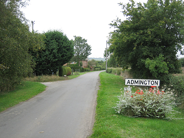
Admington

Settlement in Gloucestershire Stratford-on-Avon

England

Admington

Road to Admington Road to Admington from Lower Quinton.
Road to Admington Credit: Philip Halling

Admington is a small village located in the county of Gloucestershire, England. It lies approximately 8 miles south of the town of Stratford-upon-Avon and is nestled in the picturesque countryside of the Cotswolds. With a population of around 100 residents, Admington presents itself as a quintessential English village, known for its tranquility and natural beauty.

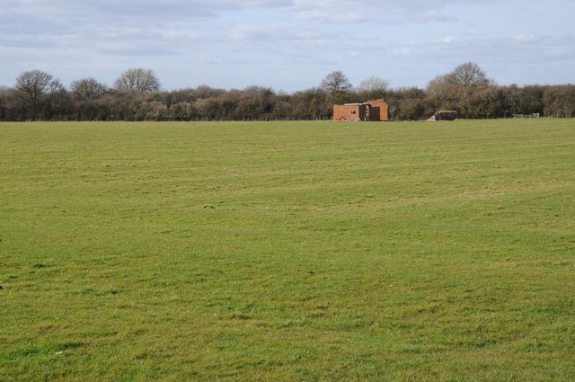
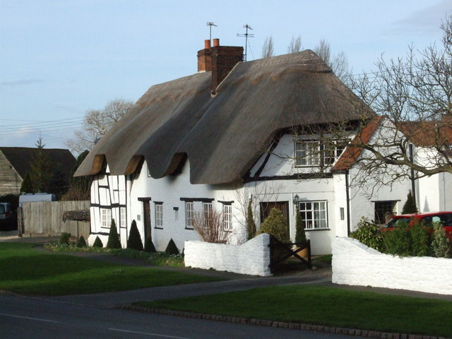
The village is characterized by its charming thatched cottages, many of which date back to the 17th century, giving Admington a timeless appeal. The surrounding landscape is dominated by rolling hills, meadows, and lush green fields, making it an ideal destination for nature lovers and hikers. The nearby Admington Woods, a designated Area of Outstanding Natural Beauty, offers a haven for wildlife and a peaceful retreat for visitors.

Despite its small size, Admington boasts a rich history. The village is mentioned in the Domesday Book of 1086, indicating its long-standing presence in the region. The local St Mary's Church, originally built in the 12th century, is a prominent landmark and a testament to the village's historical significance.

While Admington does not have its own amenities such as shops or schools, residents benefit from its close proximity to neighboring towns and villages. This ensures easy access to essential services and amenities, while still allowing them to enjoy the tranquility and idyllic lifestyle that Admington offers.

Overall, Admington, Gloucestershire, is a charming and picturesque village, renowned for its natural beauty, historical significance, and peaceful atmosphere. It provides an enchanting escape from the hustle and bustle of modern life, making it a hidden gem within the Cotswolds.

If you have any feedback on the listing, please let us know in the comments section below.

Admington Images

Images are sourced within 2km of 52.115894/-1.705709 or Grid Reference SP2046. Thanks to Geograph Open Source API. All images are credited.

Road to Admington Road to Admington from Lower Quinton.
Road to Admington
Road to Admington from Lower Quinton.
Arable field near Lower Quinton Arable field to the east of Lower Quinton, to the right the ruins of a farm building at Admington Grounds can be seen.
Arable field near Lower Quinton
Arable field to the east of Lower Quinton, to the right the ruins of a farm building at Admington Grounds can be seen.
Ruin of a farm building Ruin of a farm building at Admington Grounds.  Note the ridge and furrow in the field.
Ruin of a farm building
Ruin of a farm building at Admington Grounds. Note the ridge and furrow in the field.
Parkland at Admington Parkland to the south of Admington Hall.  Meon Hill can be seen in the distance.
Parkland at Admington
Parkland to the south of Admington Hall. Meon Hill can be seen in the distance.
Road to Upper Admington Tree-lined road to Upper Admington.
Road to Upper Admington
Tree-lined road to Upper Admington.
Lower Quinton church Lower Quinton church is dedicated to St Swithin. The church is Grade I listed.

Historic England description
Church. C12 arcades; C13 chancel; early C14 chancel arch and tower with C15 top stage and spire, C15 nave clerestory; C19 north porch. MATERIALS: coursed limestone rubble and ashlar; tile chancel roof and lead aisle roofs. Coped stone gables. PLAN: 2-bay chancel, nave with lean-to aisles, west tower, and gabled south porch. EXTERIOR: chancel has plain plinth and coursed rubble walls with ashlar quoins and tile roof; 5-light C19 east window with Decorated tracery; north side has 2-light C15 straight-headed traceried window with labelmould with head stops and 2 splayed lancets; south side has C15 window as above to left of blocked single-chamfered pointed priest's doorway, and window of 2 single-chamfered pointed lights and a further reticulated window to right. Nave east end has gable cross and 2 small lights over chancel; much-restored ashlar clerestory has cornice and coped parapet, four 2-light straight-headed windows to south and 5 to north. North aisle has offset diagonal buttresses, cornice and coped parapet; porch with entrance of 2 orders and lateral buttresses, side lights and tile roof; 3 windows of 2 lights with Decorated tracery and hoods; 3-light windows with reticulated tracery to west and east, the latter with blind central panel. South aisle similar but with no cornice or parapet; blocked entrance with continuous moulding and buttress to left; 2 traceried lights to east. 3-stage west tower has moulded plinth, diagonal buttresses and 2 string courses; top cornice and crenellated parapet with continuous roll moulding and pinnacles; tall 2-light bell openings with Y-tracery and stone louvres; to north a small window to 2nd stage with inserted clock face, small window to south; spire has 4 pinnacles to base and ribs, relief band over 2-light lucarnes and weathercock. INTERIOR: chancel has C19 collar and scissor-braced roof; wide splays to lancets and cusped rere-arch to south window; piscina with simple head; moulded chancel arch dies into walls. Nave has 2-bay Norman south arcade with stepped arches on round pier with round base and responds, hoods with heads over arches; later elliptical arch to west; 4-bay late C12 north arcade has stepped arches on round piers with square bases, responds with attached shafts and scalloped capitals; roof has arch braces on corbels and double-chamfered principals; tower arch has rich continuous mouldings, 2 former roof lines above. North aisle has roof with cambered tie beams and richly moulded purlin; piscina with trefoil head and scalloped bowl. South aisle has cusped ogee-arched sedilia and 2-light traceried double piscina. FITTINGS: nave has painted Royal arms, 1804-37; 1925 pulpit with moulded bands and pierced motifs. North aisle has round font with scalloped moulding; some pews to west have moulded muntins and top rails, used as model for C19 or C20 pews in rest of church; C20 parclose screens forming chapel at east end, altar rail incorporating C15 panel with blind tracery; painted Lord's Prayer and Ten Commandment boards, 1826. South aisle has organ to west end and painted 1860s charity boards. MONUMENTS: Sir William Clopton, d.early C15, plain chest tomb in south arcade has top slab with moulded edge and effigy of knight; Joan Clopton, d.1430, chest tomb in south aisle has panelled sides and marble top with inset brass figure, canopy, inscription and shields; Thomas and Ann Lingen, d.1735 and 1737, tablet with armorial bearing and flanking Ionic pilasters, apron, and crest with urn and cherubs; C18 and C19 wall and floor slabs to chancel. Wall painting: chancel arch has arms of Elizabeth I over partly visible Doom; south aisle has worn text in cartouche. STAINED GLASS: 2 windows to north aisle have C14 fragments; 1870 glass to east window; several windows with armorial bearings, 1922-1930, by Webb, to aisles; north aisle east window incorporating C15 figure. A well preserved church containing many features, monuments and fittings of interest. (Buildings of England: Pevsner N: Warwickshire: Harmondsworth: 1966-: 378). 
Source: <span class="nowrap"><a title="https://www.historicengland.org.uk/listing/the-list/list-entry/1382665" rel="nofollow ugc noopener" href="https://www.historicengland.org.uk/listing/the-list/list-entry/1382665">Link</a><img style="margin-left:2px;" alt="External link" title="External link - shift click to open in new window" src="https://s1.geograph.org.uk/img/external.png" width="10" height="10"/></span>
Lower Quinton church
Lower Quinton church is dedicated to St Swithin. The church is Grade I listed. Historic England description Church. C12 arcades; C13 chancel; early C14 chancel arch and tower with C15 top stage and spire, C15 nave clerestory; C19 north porch. MATERIALS: coursed limestone rubble and ashlar; tile chancel roof and lead aisle roofs. Coped stone gables. PLAN: 2-bay chancel, nave with lean-to aisles, west tower, and gabled south porch. EXTERIOR: chancel has plain plinth and coursed rubble walls with ashlar quoins and tile roof; 5-light C19 east window with Decorated tracery; north side has 2-light C15 straight-headed traceried window with labelmould with head stops and 2 splayed lancets; south side has C15 window as above to left of blocked single-chamfered pointed priest's doorway, and window of 2 single-chamfered pointed lights and a further reticulated window to right. Nave east end has gable cross and 2 small lights over chancel; much-restored ashlar clerestory has cornice and coped parapet, four 2-light straight-headed windows to south and 5 to north. North aisle has offset diagonal buttresses, cornice and coped parapet; porch with entrance of 2 orders and lateral buttresses, side lights and tile roof; 3 windows of 2 lights with Decorated tracery and hoods; 3-light windows with reticulated tracery to west and east, the latter with blind central panel. South aisle similar but with no cornice or parapet; blocked entrance with continuous moulding and buttress to left; 2 traceried lights to east. 3-stage west tower has moulded plinth, diagonal buttresses and 2 string courses; top cornice and crenellated parapet with continuous roll moulding and pinnacles; tall 2-light bell openings with Y-tracery and stone louvres; to north a small window to 2nd stage with inserted clock face, small window to south; spire has 4 pinnacles to base and ribs, relief band over 2-light lucarnes and weathercock. INTERIOR: chancel has C19 collar and scissor-braced roof; wide splays to lancets and cusped rere-arch to south window; piscina with simple head; moulded chancel arch dies into walls. Nave has 2-bay Norman south arcade with stepped arches on round pier with round base and responds, hoods with heads over arches; later elliptical arch to west; 4-bay late C12 north arcade has stepped arches on round piers with square bases, responds with attached shafts and scalloped capitals; roof has arch braces on corbels and double-chamfered principals; tower arch has rich continuous mouldings, 2 former roof lines above. North aisle has roof with cambered tie beams and richly moulded purlin; piscina with trefoil head and scalloped bowl. South aisle has cusped ogee-arched sedilia and 2-light traceried double piscina. FITTINGS: nave has painted Royal arms, 1804-37; 1925 pulpit with moulded bands and pierced motifs. North aisle has round font with scalloped moulding; some pews to west have moulded muntins and top rails, used as model for C19 or C20 pews in rest of church; C20 parclose screens forming chapel at east end, altar rail incorporating C15 panel with blind tracery; painted Lord's Prayer and Ten Commandment boards, 1826. South aisle has organ to west end and painted 1860s charity boards. MONUMENTS: Sir William Clopton, d.early C15, plain chest tomb in south arcade has top slab with moulded edge and effigy of knight; Joan Clopton, d.1430, chest tomb in south aisle has panelled sides and marble top with inset brass figure, canopy, inscription and shields; Thomas and Ann Lingen, d.1735 and 1737, tablet with armorial bearing and flanking Ionic pilasters, apron, and crest with urn and cherubs; C18 and C19 wall and floor slabs to chancel. Wall painting: chancel arch has arms of Elizabeth I over partly visible Doom; south aisle has worn text in cartouche. STAINED GLASS: 2 windows to north aisle have C14 fragments; 1870 glass to east window; several windows with armorial bearings, 1922-1930, by Webb, to aisles; north aisle east window incorporating C15 figure. A well preserved church containing many features, monuments and fittings of interest. (Buildings of England: Pevsner N: Warwickshire: Harmondsworth: 1966-: 378). Source: LinkExternal link
War memorial, Lower Quinton War memorial in the churchyard of Lower Quinton church.
War memorial, Lower Quinton
War memorial in the churchyard of Lower Quinton church.
Names on Lower Quinton war memorial #1
Names on Lower Quinton war memorial #2
Names on Lower Quinton war memorial #3
Remains of a cross, Lower Quinton The remains of a medieval preaching cross in the churchyard of Lower Quniton church.  The cross is Grade II listed.

Historic England description
Remains of medieval cross. Limestone ashlar. Large square base; socket stone with chamfered angles and 8 gablets; part of shaft with reeded angles. (Buildings of England: Pevsner N: Warwickshire: Harmondsworth: 1966-: 378). 
Source: <span class="nowrap"><a title="https://www.historicengland.org.uk/listing/the-list/list-entry/1382666" rel="nofollow ugc noopener" href="https://www.historicengland.org.uk/listing/the-list/list-entry/1382666">Link</a><img style="margin-left:2px;" alt="External link" title="External link - shift click to open in new window" src="https://s1.geograph.org.uk/img/external.png" width="10" height="10"/></span>
Remains of a cross, Lower Quinton
The remains of a medieval preaching cross in the churchyard of Lower Quniton church. The cross is Grade II listed. Historic England description Remains of medieval cross. Limestone ashlar. Large square base; socket stone with chamfered angles and 8 gablets; part of shaft with reeded angles. (Buildings of England: Pevsner N: Warwickshire: Harmondsworth: 1966-: 378). Source: LinkExternal link
Thatched cottage Attractive thatched cottage opposite Lower Quinton church.
Thatched cottage
Attractive thatched cottage opposite Lower Quinton church.
Road to Upper Admington
Field beside Admington Lane Farm Not sure but the field in the foreground may be a polo field.  Meon Hill is on the right.
Field beside Admington Lane Farm
Not sure but the field in the foreground may be a polo field. Meon Hill is on the right.
Country road to Upper Admington
Dilapidated road sign Dilapidated road sign on a road junction near Lower Quinton.
Dilapidated road sign
Dilapidated road sign on a road junction near Lower Quinton.
Meon Hill View across farmland to Meon Hill, the only Cotswold outlier in Warwickshire.
Meon Hill
View across farmland to Meon Hill, the only Cotswold outlier in Warwickshire.
Country road at Harbour Hill
Show me another place!

Admington is located at Grid Ref: SP2046 (Lat: 52.115894, Lng: -1.705709)

Administrative County: Warwickshire

District: Stratford-on-Avon

Police Authority: Warwickshire

What 3 Words

///pylon.foggy.frown. Near Mickleton, Gloucestershire

Nearby Locations

Admington

Related Wikis

Admington

Admington is a village and civil parish in the Stratford-on-Avon district of the English county of Warwickshire. The name Admington means "estate associated...

Whitchurch, Warwickshire

Whitchurch is a parish and a small hamlet lying on the left bank of the River Stour in Warwickshire, England, some four miles south-south-east of the town...

Quinton, Warwickshire

Quinton is a civil parish in the Stratford-on-Avon district of Warwickshire, England, about six miles south of Stratford-upon-Avon. According to the 2001...

Ailstone

Ailstone is a village in Warwickshire, England. Population details can be found under Preston-on-Stour == External links == Media related to Ailstone...

Ilmington

Ilmington is a village and civil parish about 3.5 miles (5.6 km) north-west of Shipston-on-Stour and 8 miles (13 km) south of Stratford-upon-Avon in the...

Alderminster

Alderminster is a village and civil parish on the River Stour about 4 miles (6.4 km) south of Stratford-upon-Avon in Warwickshire, England. The village...

Preston on Stour

Preston on Stour is a village and civil parish in Warwickshire, England. == History == It is situated some four kilometres south of the town of Stratford...

Stratford-on-Avon (UK Parliament constituency)

Stratford-on-Avon is a constituency represented in the House of Commons of the UK Parliament since 2010 by Nadhim Zahawi, a member of the Conservative...

Nearby Amenities

Located within 500m of 52.115894,-1.705709
Admington
Place: hamlet
Source: NPE
Wikidata: Q358740
Wikipedia: en:Admington
Lat/Long: 52.1133553/-1.7073472
Bus Stop
Bus Shelter
Bus: yes
Naptan AtcoCode: 4200F000200
Naptan Bearing: NE
Naptan CommonName: Bus Shelter
Naptan Indicator: Adj
Naptan NaptanCode: waradgmd
Naptan Street: Cotswold Close
Naptan Verified: no
Public Transport: platform
Shelter: yes
Source: naptan_import
Lat/Long: 52.1133638/-1.7074233
Bus Shelter
Naptan AtcoCode: 4200F000201
Naptan Bearing: SW
Naptan BusStopType: CUS
Naptan CommonName: Bus Shelter
Naptan Indicator: Opp
Naptan NaptanCode: wardjptw
Naptan Street: Cotswold Close
Naptan Verified: no
Source: naptan_import
Lat/Long: 52.112817/-1.7078909
Post Box
Collection Times: Mo-Fr 14:00; Sa 07:30
Operator: Royal Mail
Operator Wikidata: Q638098
Post Box Type: wall
Ref: CV36 116
Royal Cypher: VR
Royal Cypher Wikidata: Q33102356
Source: survey
Lat/Long: 52.1132689/-1.7073393
Public Bookcase
Defibrillator
Booth: K6
Colour: red
Defibrillator Location: inside red phone box (which is now a book exchange) in Adminton
Disused Amenity: telephone
Emergency: defibrillator
Man Made: telephone_box
Public Bookcase Type: phone_box
Lat/Long: 52.1133951/-1.7073802
Power: pole
Source: bing
Lat/Long: 52.1144977/-1.7011991
Power: pole
Source: bing
Lat/Long: 52.1148123/-1.7003301
Power: pole
Source: bing
Lat/Long: 52.1151417/-1.6994128
Power: pole
Source: bing
Lat/Long: 52.1154662/-1.6985062
The data included in this document is from www.openstreetmap.org. The data is made available under ODbL.

Have you been to Admington?

Leave your review of Admington below (or comments, questions and feedback).