Salvington

Settlement in Sussex Worthing

England

Salvington

The Cricketers public house Shopping street with Pastel blue lamp posts for the coastal theme.
The Cricketers public house Credit: James Emmans

Salvington is a small village located in the county of West Sussex, England. Situated approximately 50 miles south-west of London, it falls within the borough of Worthing. The village is nestled on the slopes of the South Downs, offering picturesque views of the surrounding countryside.

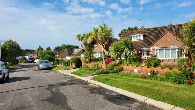
With a population of around 2,500 residents, Salvington exudes a charming, tight-knit community atmosphere. The village is primarily residential, characterized by a mix of traditional brick-built houses and newer developments. The architecture reflects a blend of classic English styles, showcasing the village's rich history.

Salvington is well-served by local amenities, including a primary school, a village hall, and a small selection of shops and local businesses. The village also boasts several green spaces, providing opportunities for outdoor activities and leisurely walks amidst the tranquil countryside.

For those seeking recreational opportunities, Salvington is conveniently located near the South Downs National Park, offering expansive areas for hiking, cycling, and nature exploration. Additionally, the nearby town of Worthing provides a wider range of amenities, including shopping centers, restaurants, and entertainment venues.

Transport links in Salvington are efficient, with regular bus services connecting the village to neighboring towns and villages. The nearby A27 road provides easy access to larger cities such as Brighton and Chichester, while Worthing railway station offers direct train connections to London and other major destinations.

In summary, Salvington is a delightful village in West Sussex, offering a peaceful countryside setting with close proximity to larger towns and excellent transport links. Its strong sense of community and beautiful surroundings make it an appealing place to live or visit.

If you have any feedback on the listing, please let us know in the comments section below.

Salvington Images

Images are sourced within 2km of 50.834475/-0.393129 or Grid Reference TQ1305. Thanks to Geograph Open Source API. All images are credited.

The Cricketers public house Shopping street with Pastel blue lamp posts for the coastal theme.
The Cricketers public house
Shopping street with Pastel blue lamp posts for the coastal theme.
Border of the Southdown National Park Footpath next to a Hill Barn Golf Club.

Park info : <span class="nowrap"><a title="https://en.wikipedia.org/wiki/South_Downs_National_Park" rel="nofollow ugc noopener" href="https://en.wikipedia.org/wiki/South_Downs_National_Park">Link</a><img style="margin-left:2px;" alt="External link" title="External link - shift click to open in new window" src="https://s1.geograph.org.uk/img/external.png" width="10" height="10"/></span>
Border of the Southdown National Park
Footpath next to a Hill Barn Golf Club. Park info : LinkExternal link
Bungalows in Hillside Avenue Housing on the edge of Worthing.
Bungalows in Hillside Avenue
Housing on the edge of Worthing.
Lavington Road Detached 1930's houses, with new attic rooms.
Lavington Road
Detached 1930's houses, with new attic rooms.
St Lawrence Avenue 1920's detached housing in an area called West Tarring.
St Lawrence Avenue
1920's detached housing in an area called West Tarring.
Valencia Road cleared for the Queen's platinum jubilee street party The road is close to West Worthing Station.
Valencia Road cleared for the Queen's platinum jubilee street party
The road is close to West Worthing Station.
Grand Avenue, West Worthing Grand Avenue is a residential road in West Worthing.
Grand Avenue, West Worthing
Grand Avenue is a residential road in West Worthing.
Valencia Road, West Worthing Valencia Road is a residential road in West Worthing.
Valencia Road, West Worthing
Valencia Road is a residential road in West Worthing.
West Worthing Station West Worthing station building.  The station is on the West Coastway line.

The queue of traffic to the right of the image is waiting for a train to enter the station across a level crossing.
West Worthing Station
West Worthing station building. The station is on the West Coastway line. The queue of traffic to the right of the image is waiting for a train to enter the station across a level crossing.
Level crossing at West Worthing A level crossing takes the West Coastway railway line across the A2031 road at West Worthing.

In this image, the level crossing barriers are down, as a train is due.
Level crossing at West Worthing
A level crossing takes the West Coastway railway line across the A2031 road at West Worthing. In this image, the level crossing barriers are down, as a train is due.
St. Dunstan's Road, West Worthing St. Dunstan's Road is a residential street in West Worthing.
St. Dunstan's Road, West Worthing
St. Dunstan's Road is a residential street in West Worthing.
Church Road, West Worthing Church Road is a residential road in West Worthing.
Church Road, West Worthing
Church Road is a residential road in West Worthing.
Church Road, West Worthing Church Road is a residential road in West Worthing.
Church Road, West Worthing
Church Road is a residential road in West Worthing.
Bellview Road, West Worthing Bellview Road is a residential road in West Worthing.
Bellview Road, West Worthing
Bellview Road is a residential road in West Worthing.
Pelham Road, West Worthing Pelham Road is a residential road in West Worthing.
Pelham Road, West Worthing
Pelham Road is a residential road in West Worthing.
Terringes Avenue, West Worthing Terringes Avenue is a residential road in West Worthing.
Terringes Avenue, West Worthing
Terringes Avenue is a residential road in West Worthing.
High Street, Tarring, near Worthing High Street in Tarring, in the suburbs of Worthing.
High Street, Tarring, near Worthing
High Street in Tarring, in the suburbs of Worthing.
Old School House, Tarring, near Worthing The name "Old School House" indicates that this building was originally a school.
Old School House, Tarring, near Worthing
The name "Old School House" indicates that this building was originally a school.
Show me another place!

Salvington is located at Grid Ref: TQ1305 (Lat: 50.834475, Lng: -0.393129)

Administrative County: West Sussex

District: Worthing

Police Authority: Sussex

What 3 Words

///snails.occupiers.whiplash. Near Broadwater, West Sussex

Nearby Locations

Salvington Mill Plantation

Related Wikis

Offington

Offington is a neighbourhood of Worthing, in the borough of Worthing in West Sussex, England. It lies on the A2031 road 1.6 miles (2.5 km) northwest of...

Salvington

Salvington is a neighbourhood of Worthing, in the borough of Worthing in West Sussex, England. It lies south of the A27 road two miles (3 km) north-west...

Worthing Golf Club

Worthing Golf Club is a golf club on the South Downs at Worthing, England. Located close to the Iron Age hill fort of Cissbury Ring in the new South Downs...

Durrington High School

Durrington High School is a Coeducational secondary school located in Worthing, West Sussex. The school operated as a high school between 1973 and 2015...

Durrington & Salvington (electoral division)

Durrington & Salvington is an electoral division of West Sussex in England, and returns one member to sit on West Sussex County Council. == Extent == The...

Tarring, West Sussex

Tarring (), officially West Tarring, is a neighbourhood of Worthing, in the borough of Worthing in West Sussex, England. It lies on the A2031 road 1 mile...

St Andrew's Church, West Tarring

St Andrew's Church is the Church of England parish church of Tarring, West Sussex, England. Founded in the 11th century in a then rural parish which had...

Tarring (electoral division)

Tarring is an electoral division of West Sussex in the United Kingdom, and returns one member to sit on West Sussex County Council. == Extent == The division...

Nearby Amenities

Located within 500m of 50.834475,-0.393129
Traffic Signals
Lat/Long: 50.8303364/-0.3920279
Bus Stop
Cleveland Road
Naptan AtcoCode: 4400WO0036
Naptan Bearing: E
Naptan CommonName: Cleveland Road
Naptan Indicator: o/s 10
Naptan Landmark: Half Moon Lane
Naptan NaptanCode: wsxdmjpg
Naptan Street: Cleveland Road
Naptan Verified: no
Source: naptan_import
Lat/Long: 50.835799/-0.3991104
Bus Stop
Highfield Road
Naptan AtcoCode: 4400WO0113
Naptan Bearing: E
Naptan CommonName: Highfield Road
Naptan Indicator: opp
Naptan Landmark: Highfield Road
Naptan NaptanCode: wsxdmtdg
Naptan ShortCommonName: Highfield Road
Naptan Street: Littlehampton Road
Naptan Verified: no
Shelter: yes
Source: naptan_import
Lat/Long: 50.8303734/-0.3930336
Bus Stop
Thomas-A-Becket PH
Naptan AtcoCode: 4400WO0114
Naptan Bearing: W
Naptan CommonName: Thomas-A-Becket PH
Naptan Indicator: o/s 113
Naptan Landmark: Offington Lane
Naptan NaptanCode: wsxdmtdj
Naptan ShortCommonName: Thomas-A-Becket PH
Naptan Street: Poulters Lane
Naptan Verified: no
Shelter: no
Source: naptan_import
Lat/Long: 50.8302737/-0.3910205
Bus Stop
Thomas-A-Becket PH
Naptan AtcoCode: 4400WO0115
Naptan Bearing: E
Naptan CommonName: Thomas-A-Becket PH
Naptan Indicator: o/s 78
Naptan Landmark: Offington Lane
Naptan NaptanCode: wsxdmtdm
Naptan ShortCommonName: Thomas-A-Becket PH
Naptan Street: Poulters Lane
Naptan Verified: no
Source: naptan_import
Lat/Long: 50.8304703/-0.3909285
Bus Stop
Offington Drive
Naptan AtcoCode: 4400WO0131
Naptan Bearing: W
Naptan CommonName: Offington Drive
Naptan Indicator: o/s 105
Naptan Landmark: Offington Drive
Naptan NaptanCode: wsxdmtjt
Naptan Street: Warren Road
Naptan Verified: no
Public Transport: platform
Source: naptan_import
Lat/Long: 50.8381201/-0.3891808
Bus Stop
Offington Corner South
Naptan AtcoCode: 4400WO0132
Naptan Bearing: SE
Naptan CommonName: Offington Corner South
Naptan Indicator: nr roundabout
Naptan Landmark: Warren Road
Naptan NaptanCode: wsxdmtjw
Naptan ShortCommonName: Offington Corner South
Naptan Street: Offington Lane
Naptan Verified: no
Source: naptan_import
Lat/Long: 50.8381217/-0.3920857
Bus Stop
The Plantation
Naptan AtcoCode: 4400WO0133
Naptan Bearing: N
Naptan CommonName: The Plantation
Naptan Indicator: adj
Naptan Landmark: The Plantation
Naptan NaptanCode: wsxdmtma
Naptan ShortCommonName: The Plantation
Naptan Street: Offington Lane
Naptan Verified: no
Source: naptan_import
Lat/Long: 50.8369019/-0.3916731
Bus Stop
The Plantation
Naptan AtcoCode: 4400WO0134
Naptan Bearing: S
Naptan CommonName: The Plantation
Naptan Indicator: opp
Naptan Landmark: The Plantation
Naptan NaptanCode: wsxdmtmd
Naptan ShortCommonName: The Plantation
Naptan Street: Offington Lane
Naptan Verified: no
Source: naptan_import
Lat/Long: 50.8363056/-0.3914806
Bus Stop
Ashacre Lane
Naptan AtcoCode: 4400WO0135
Naptan Bearing: N
Naptan CommonName: Ashacre Lane
Naptan Indicator: adj
Naptan Landmark: Offington Avenue
Naptan NaptanCode: wsxdmtmg
Naptan ShortCommonName: Ashacre Lane
Naptan Street: Offington Lane
Naptan Verified: no
Source: naptan_import
Lat/Long: 50.8344402/-0.3918571
Bus Stop
Ashacre Lane
Naptan AtcoCode: 4400WO0136
Naptan Bearing: S
Naptan CommonName: Ashacre Lane
Naptan Indicator: adj
Naptan Landmark: Offington Avenue
Naptan NaptanCode: wsxdmtmj
Naptan ShortCommonName: Ashacre Lane
Naptan Street: Offington Lane
Naptan Verified: no
Source: naptan_import
Lat/Long: 50.8334477/-0.3916214
Bus Stop
Rogate Road
Naptan AtcoCode: 4400WO0137
Naptan Bearing: S
Naptan CommonName: Rogate Road
Naptan Indicator: opp
Naptan Landmark: Rogate Road
Naptan NaptanCode: wsxdmtmp
Naptan ShortCommonName: Rogate Road
Naptan Street: Offington Lane
Naptan Verified: no
Source: naptan_import
Lat/Long: 50.8317135/-0.3917378
Bus Stop
Rogate Road
Naptan AtcoCode: 4400WO0138
Naptan Bearing: N
Naptan CommonName: Rogate Road
Naptan Indicator: adj
Naptan Landmark: Rogate Road
Naptan NaptanCode: wsxdmtmt
Naptan ShortCommonName: Rogate Road
Naptan Street: Offington Lane
Naptan Verified: no
Source: naptan_import
Lat/Long: 50.8309442/-0.3920341
Bus Stop
Barn Close
Naptan AtcoCode: 4400WO0154
Naptan Bearing: N
Naptan CommonName: Barn Close
Naptan Indicator: adj
Naptan Landmark: Salvington Road
Naptan NaptanCode: wsxdmwad
Naptan ShortCommonName: Barn Close
Naptan Street: Stone Lane
Naptan Verified: no
Source: naptan_import
Lat/Long: 50.8346959/-0.3993327
Bus Stop
Barn Close
Naptan AtcoCode: 4400WO0155
Naptan Bearing: S
Naptan CommonName: Barn Close
Naptan Indicator: opp
Naptan Landmark: Salvington Road
Naptan NaptanCode: wsxdmwag
Naptan ShortCommonName: Barn Close
Naptan Street: Stone Lane
Naptan Verified: no
Source: naptan_import
Lat/Long: 50.8348993/-0.3990844
Bus Stop
Offington Corner West
Naptan AtcoCode: 4400WO0214
Naptan Bearing: W
Naptan CommonName: Offington Corner West
Naptan Indicator: adj
Naptan Landmark: Goodwood Road
Naptan NaptanCode: wsxdpagp
Naptan ShortCommonName: Offington Corner West
Naptan Street: Crockhurst Hill
Naptan Verified: no
Source: naptan_import
Lat/Long: 50.8386583/-0.3938284
Offington Corner West
Naptan AtcoCode: 4400WO0473
Naptan Bearing: E
Naptan BusStopType: CUS
Naptan CommonName: Offington Corner West
Naptan Indicator: opp
Naptan Landmark: Goodwood Road
Naptan NaptanCode: wsxgdwjd
Naptan ShortCommonName: Offington Corner West
Naptan Street: Crockhurst Hill
Naptan Verified: no
Source: naptan_import
Lat/Long: 50.8388912/-0.3937636
Bus Stop
Offington Corner East
Naptan AtcoCode: 4400WO0477
Naptan Bearing: SE
Naptan CommonName: Offington Corner East
Naptan Indicator: at
Naptan Landmark: Warren Road
Naptan NaptanCode: wsxgdpma
Naptan ShortCommonName: Offington Corner East
Naptan Street: A24
Naptan Verified: no
Public Transport: platform
Source: naptan_import
Lat/Long: 50.8386838/-0.391684
Post Box
Brand: Royal Mail
Brand Wikidata: Q638098
Brand Wikipedia: en:Royal Mail
Collection Plate: CP1
Collection Times: Mo-Fr 17:00; Sa 12:30
Operator: Royal Mail
Operator Wikidata: Q638098
Post Box Type: pillar
Ref: BN14 1657
Royal Cypher: EIIR
Royal Cypher Wikidata: Q33102113
Lat/Long: 50.8306305/-0.3920491
Post Box
Brand: Royal Mail
Brand Wikidata: Q638098
Brand Wikipedia: en:Royal Mail
Collection Plate: CP7D
Collection Times: Mo-Fr 09:00; Sa 07:00
Last Checked: 2020-12-04
Operator: Royal Mail
Operator Wikidata: Q638098
Post Box Type: lamp
Ref: BN14 1761D
Royal Cypher: EIIR
Royal Cypher Wikidata: Q33102113
Lat/Long: 50.8343687/-0.3918334
Post Box
Brand: Royal Mail
Brand Wikidata: Q638098
Brand Wikipedia: en:Royal Mail
Collection Plate: CP1
Collection Times: Mo-Fr 17:00; Sa 11:45
Operator: Royal Mail
Operator Wikidata: Q638098
Post Box Type: pillar
Ref: BN13 1760
Royal Cypher: EIIR
Royal Cypher Wikidata: Q33102113
Lat/Long: 50.8350895/-0.398883
Generator Method: photovoltaic
Generator Output Electricity: yes
Generator Source: solar
Generator Type: solar_photovoltaic_panel
Location: roof
Power: generator
Lat/Long: 50.8382992/-0.3947708
Generator Method: photovoltaic
Generator Output Electricity: yes
Generator Source: solar
Generator Type: solar_photovoltaic_panel
Location: roof
Power: generator
Lat/Long: 50.8356294/-0.3903548
Generator Method: photovoltaic
Generator Output Electricity: yes
Generator Source: solar
Generator Type: solar_photovoltaic_panel
Location: roof
Power: generator
Lat/Long: 50.8331423/-0.392163
Generator Method: photovoltaic
Generator Output Electricity: yes
Generator Source: solar
Generator Type: solar_photovoltaic_panel
Location: roof
Power: generator
Lat/Long: 50.8306391/-0.391035
Generator Method: photovoltaic
Generator Output Electricity: yes
Generator Source: solar
Generator Type: solar_photovoltaic_panel
Location: roof
Power: generator
Lat/Long: 50.8346535/-0.3860684
Traffic Signals
Source: aerial imagery
Traffic Signals: pedestrian_crossing
Traffic Signals Direction: both
Lat/Long: 50.8386357/-0.3917325
Waste Basket
Lat/Long: 50.8307034/-0.3962055
Waste Basket
Lat/Long: 50.8307785/-0.3957258
Waste Basket
Lat/Long: 50.8318474/-0.3950108
Waste Basket
Waste: dog_excrement
Lat/Long: 50.8325615/-0.3964841
Waste Basket
Waste: dog_excrement
Lat/Long: 50.8308536/-0.3964732
Waste Basket
Waste: dog_excrement
Lat/Long: 50.830831/-0.3964704
Waste Basket
Lat/Long: 50.8306506/-0.3960646
Waste Basket
Lat/Long: 50.8329338/-0.3966125
The data included in this document is from www.openstreetmap.org. The data is made available under ODbL.

Have you been to Salvington?

Leave your review of Salvington below (or comments, questions and feedback).