Patton Bridge

Settlement in Westmorland South Lakeland

England

Patton Bridge

The Mint Valley
The Mint Valley Credit: N Chadwick

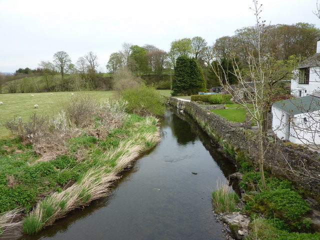
Patton Bridge is a picturesque village located in the county of Westmorland, in the North West of England. Situated on the banks of the River Lune, it is renowned for its stunning natural beauty and tranquil atmosphere.

The centerpiece of the village is the historic Patton Bridge, a stone structure that spans the river and dates back to the 17th century. The bridge is a Grade II listed building, reflecting its architectural and historical significance. Its elegant design and sturdy construction have ensured its survival through the centuries, making it an iconic landmark of the area.

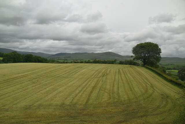
Surrounded by rolling hills and lush green meadows, Patton Bridge offers breathtaking views of the countryside. The village itself is small and charming, with a scattering of traditional stone buildings and cottages. It exudes a sense of tranquility and provides a perfect escape from the hustle and bustle of modern life.

Nature enthusiasts will appreciate the abundance of wildlife that can be found in the area. The River Lune is home to various species of fish, while the surrounding woodlands and fields attract a diverse range of birds and mammals. This makes Patton Bridge a popular destination for birdwatching, fishing, and peaceful walks along the riverbanks.

Visitors to Patton Bridge can also explore the nearby attractions, such as the historic market town of Kirkby Lonsdale, which is just a short drive away. With its charming shops, cafes, and traditional architecture, it offers a delightful glimpse into the region's past.

In summary, Patton Bridge is a hidden gem in the heart of Westmorland, offering a serene retreat for nature lovers and history enthusiasts alike.

If you have any feedback on the listing, please let us know in the comments section below.

Patton Bridge Images

Images are sourced within 2km of 54.370025/-2.682898 or Grid Reference SD5597. Thanks to Geograph Open Source API. All images are credited.

The Mint Valley
The Mint Valley
Field by West Coast Main Line
Flodden Beck
Flodden Beck
Looking towards Whinfell Common West Coast main line in the cutting. Mallard exiting shot left.
Looking towards Whinfell Common
West Coast main line in the cutting. Mallard exiting shot left.
Beck Docker Bridge Enters the River Mint before it leaves the square
Beck Docker Bridge
Enters the River Mint before it leaves the square
Viaduct near Docker Bridge Carries west coast main line
Viaduct near Docker Bridge
Carries west coast main line
Country Road Near Crake Hall Crake Hall in the trees
Country Road Near Crake Hall
Crake Hall in the trees
Sheep and Lamb From the crossroads near Browfoot
Sheep and Lamb
From the crossroads near Browfoot
Patton Bridge Over the River Mint
Patton Bridge
Over the River Mint
The Joys of the Single Track Road Go for the ones with grass down the middle. Near Patton Bridge
The Joys of the Single Track Road
Go for the ones with grass down the middle. Near Patton Bridge
Wall Field End Above the farm. Howgills in the distance
Wall Field End
Above the farm. Howgills in the distance
Patton Hall From the road to Kendal from Patton Bridge
Patton Hall
From the road to Kendal from Patton Bridge
Track, Evattsike Near Whinfell Beacon
Track, Evattsike
Near Whinfell Beacon
Whinhowe Gill Surprisingly desert like on the hottest day of the year so far.
Whinhowe Gill
Surprisingly desert like on the hottest day of the year so far.
Bowthwaite Bridge Small bridge which carries a minor road over Light Water
Bowthwaite Bridge
Small bridge which carries a minor road over Light Water
Light Water It eventually flows into the River Mint N of Patton Bridge
Light Water
It eventually flows into the River Mint N of Patton Bridge
Sheep Sheep NE of The Borrans with Moorbank Farm in the distance
Sheep
Sheep NE of The Borrans with Moorbank Farm in the distance
Gate Just N of The Borrans on the way to Howestone.
Gate
Just N of The Borrans on the way to Howestone.
Show me another place!

Patton Bridge is located at Grid Ref: SD5597 (Lat: 54.370025, Lng: -2.682898)

Administrative County: Cumbria

District: South Lakeland

Police Authority: Cumbria

What 3 Words

///partners.awoke.powers. Near Burneside, Cumbria

Related Wikis

Patton Bridge

Patton Bridge is a small rural hamlet approximately 5 miles from the outskirts of Kendal, Cumbria, England. Its post code region is LA8.

Whinfell

Whinfell is a civil parish in South Lakeland, Cumbria, England. It does not have a parish council but a parish meeting. The parish lies north east of Kendal...

Docker, Cumbria

Docker is a civil parish in the South Lakeland district of the English county of Cumbria. Docker is 4.3 miles north east of the market town of Kendal....

Grayrigg derailment

The Grayrigg derailment was a fatal railway accident that occurred at approximately 20:15 GMT on 23 February 2007, just to the south of Grayrigg, Cumbria...

Nearby Amenities

Located within 500m of 54.370025,-2.682898
Created By: Merkaartor 0.13
Lat/Long: 54.3699816/-2.6799191
Created By: Merkaartor 0.13
Lat/Long: 54.3728545/-2.6862036
Created By: Merkaartor 0.13
Lat/Long: 54.3731239/-2.6862036
Created By: Merkaartor 0.13
Lat/Long: 54.3692289/-2.6836668
Created By: Merkaartor 0.13
Lat/Long: 54.3690651/-2.6837696
Created By: Merkaartor 0.13
Lat/Long: 54.3687716/-2.6837696
Created By: Merkaartor 0.13
Lat/Long: 54.3686146/-2.6838725
Created By: Merkaartor 0.13
Lat/Long: 54.3685259/-2.6840668
Created By: Merkaartor 0.13
Lat/Long: 54.3685191/-2.6848326
Created By: Merkaartor 0.13
Lat/Long: 54.3685191/-2.6851297
Created By: Merkaartor 0.13
Lat/Long: 54.3684576/-2.685404
Created By: Merkaartor 0.13
Lat/Long: 54.368328/-2.6857697
Created By: Merkaartor 0.13
Lat/Long: 54.3675909/-2.6874269
Created By: Merkaartor 0.13
Lat/Long: 54.3674612/-2.6876784
Created By: Merkaartor 0.13
Lat/Long: 54.3672906/-2.6877926
Created By: Merkaartor 0.13
Lat/Long: 54.3668606/-2.6878269
Created By: Merkaartor 0.13
Lat/Long: 54.3666764/-2.687907
Post Box
Ref: LA8 44
Source: survey
Lat/Long: 54.3699271/-2.6830266
Barrier: stile
Bicycle: no
Foot: yes
Horse: no
Motor Vehicle: no
Lat/Long: 54.3729014/-2.6863546
Barrier: stile
Source: local knowledge
Lat/Long: 54.3687587/-2.6887052
Communication Radio: yes
Description: VHF Radio repeater mast
Man Made: mast
Tower Type: communication
Lat/Long: 54.3696581/-2.6891184
Give Way
Direction: backward
Lat/Long: 54.370047/-2.6829209
Barrier: stile
Lat/Long: 54.3737681/-2.685414
Power: pole
Lat/Long: 54.3732494/-2.6787933
Power: pole
Lat/Long: 54.3722161/-2.6796229
Power: pole
Lat/Long: 54.3717008/-2.6800812
Power: pole
Lat/Long: 54.3710734/-2.6805441
Power: pole
Lat/Long: 54.3708921/-2.6806958
Fixme: Unfinished
Power: pole
Lat/Long: 54.370251/-2.6811583
Power: pole
Lat/Long: 54.37006/-2.675373
Power: pole
Lat/Long: 54.3706878/-2.6766481
Power: pole
Lat/Long: 54.3710916/-2.6780496
Power: pole
Lat/Long: 54.3695717/-2.6817162
Power: pole
Lat/Long: 54.3692602/-2.6819894
Power: pole
Lat/Long: 54.3682433/-2.6827737
Power: pole
Lat/Long: 54.3672666/-2.6828867
Power: pole
Lat/Long: 54.366737/-2.6828782
Power: pole
Lat/Long: 54.3661209/-2.6828749
Power: pole
Lat/Long: 54.3729966/-2.686533
Power: pole
Lat/Long: 54.3726399/-2.6857218
Power: pole
Lat/Long: 54.3722047/-2.6847234
Power: pole
Lat/Long: 54.3717626/-2.6837637
Power: pole
Lat/Long: 54.3713971/-2.682971
Power: pole
Lat/Long: 54.3708853/-2.6828799
Power: pole
Lat/Long: 54.3704471/-2.6824296
Power: pole
Lat/Long: 54.3686756/-2.6809724
Power: pole
Lat/Long: 54.368764/-2.6854604
The data included in this document is from www.openstreetmap.org. The data is made available under ODbL.

Have you been to Patton Bridge?

Leave your review of Patton Bridge below (or comments, questions and feedback).