Acomb

Settlement in Yorkshire

England

Acomb

Chaloners Road, York This grid square is almost empty on the 1940s map, but has now been filled with late-20th Century housing developments.
Chaloners Road, York Credit: John Armitstead

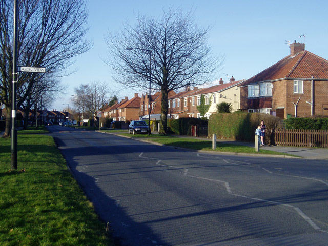
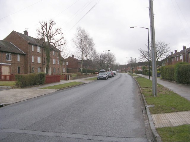
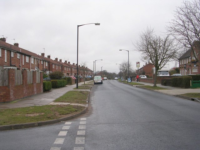
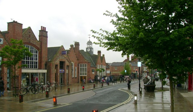
Acomb is a suburban area located in the city of York, in the county of Yorkshire, England. It is situated about 2.5 miles west of the city center and lies on the banks of the River Ouse. Acomb is primarily a residential neighborhood, providing a peaceful and family-friendly environment.

The area has a rich history, with evidence of human settlements dating back to the Roman times. Acomb developed as a village in the medieval era and gradually expanded over the centuries to become part of the urban landscape of York. Today, it retains some of its historical charm, with a mix of old and modern buildings.

Acomb offers a range of amenities and facilities to its residents. There are several local shops, supermarkets, and a lively market held twice a week, where residents can find fresh produce and a variety of goods. The neighborhood also has a library, a leisure center, and a community center, providing opportunities for cultural and recreational activities.

Transportation in Acomb is well-served, with regular bus services connecting the area to the city center and other parts of York. The nearby A1237 ring road provides convenient access to major highways, making it easily accessible for commuters.

Surrounded by beautiful countryside, Acomb offers residents the opportunity to enjoy outdoor activities. The area is home to several parks and green spaces, including the popular West Bank Park, which hosts various events throughout the year.

Overall, Acomb is a pleasant and thriving neighborhood that combines a sense of community with modern amenities, making it an attractive place to live in Yorkshire.

If you have any feedback on the listing, please let us know in the comments section below.

Acomb Images

Images are sourced within 2km of 53.956152/-1.127648 or Grid Reference SE5751. Thanks to Geograph Open Source API. All images are credited.

Chaloners Road, York This grid square is almost empty on the 1940s map, but has now been filled with late-20th Century housing developments.
Chaloners Road, York
This grid square is almost empty on the 1940s map, but has now been filled with late-20th Century housing developments.
Nacreous Clouds Sometimes also called Mother of Pearl Clouds. 
Nacreous clouds resemble pale cirrus or lenticular altocumulus and show very marked irisation, the most brilliant colours occurring when the sun is just below the horizon (before dawn or after sunset). They can still be distinguished up to about two hours after sunset as thin grey clouds standing out against the starry sky. In moonlight they may be visible throughout the night. These clouds occur at an altitude between 21 and 30 km and require a temperature approaching -90°C to form.
Source: Meteorological Office
Nacreous Clouds
Sometimes also called Mother of Pearl Clouds. Nacreous clouds resemble pale cirrus or lenticular altocumulus and show very marked irisation, the most brilliant colours occurring when the sun is just below the horizon (before dawn or after sunset). They can still be distinguished up to about two hours after sunset as thin grey clouds standing out against the starry sky. In moonlight they may be visible throughout the night. These clouds occur at an altitude between 21 and 30 km and require a temperature approaching -90°C to form. Source: Meteorological Office
View from Bridge EMM4/7 - St Helen's Road
Moor Grove - Thanet Road
Northfield Terrace - Thanet Road
Railway Terrace - Thanet Road
Thanet Road - viewed from Eason View
Eason View - Thanet Road
Eason Road - Eason View
Turnmire Road - Eason View
Gower Road - Eason View
Leeside - Eason View
Sandcroft Road - West Thorpe
West Thorpe Methodist Church - West Thorpe
West Thorpe - Thanet Road
Thanet Road - viewed from West Thorpe
Turf Tavern - Thanet Road
Show me another place!

Acomb is located at Grid Ref: SE5751 (Lat: 53.956152, Lng: -1.127648)

Division: West Riding

Unitary Authority: York

Police Authority: North Yorkshire

What 3 Words

///reef.snack.nurses. Near York, North Yorkshire

Nearby Locations

Carr Hill Acomb

Related Wikis

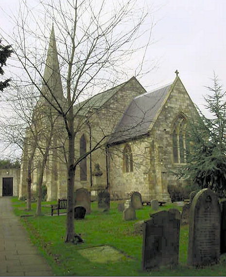
St Stephen's Church, Acomb

St Stephen's Church is the parish church of Acomb, a suburb of York in England. A church has lain on the site since the Saxon period, and some remains...

Acomb House

Acomb House is a historic building in the Acomb suburb of York, in England. The building lies on the north side of Front Street, in Acomb. Its site is...

Acomb, North Yorkshire

Acomb , is a village and suburb within the City of York unitary authority area, to the western side of York, England. It covers the site of the original...

Gateway Church, York

Gateway Church is a Christian church based in The Gateway Centre, Acomb, York, England. Formerly known as Acomb Christian Fellowship, it is part of the...

York Cold War Bunker

The York Cold War Bunker is a two-storey, semi-subterranean, Cold War bunker in the Holgate area of York, England, built in 1961 to monitor nuclear explosions...

York High School, York

York High School is a mixed secondary school in York, North Yorkshire, England. It has a comprehensive admissions policy, and in 2016 had an enrolment...

Holgate Windmill

Holgate Windmill is a tower mill at Holgate in York, North Yorkshire, England which has been restored to working order. == History == Holgate tower windmill...

Holgate, York

Holgate is a suburb of York in England. It is located about 1 mile west of Micklegate Bar in the city walls. Holgate is also the name of an electoral...

Related Videos

The brand-new Intercity trains that Britain abandoned…

The UK railways have been really busy recently, with lots of overcrowding and cancellations. But this is the story of the five year ...

Travel by Rocket Locomotive

A journey to #York by Stephenson's #Rocket replica just as it was in the early years of steam locomotion.

Nearby Amenities

Located within 500m of 53.956152,-1.127648
Crossing
Button Operated: yes
Crossing: traffic_signals
Crossing Island: no
Crossing Ref: pelican
Kerb: lowered
Tactile Paving: yes
Traffic Signals Sound: yes
Traffic Signals Vibration: yes
Lat/Long: 53.9543695/-1.1280022
Acomb
Is In: York, England
Note Population: 2001 census
Place: suburb
Population: 7729
Wikidata: Q4674476
Wikipedia: en:Acomb, North Yorkshire
Lat/Long: 53.9553132/-1.1255523
Crossing
Button Operated: yes
Crossing: traffic_signals
Crossing Island: no
Crossing Ref: pelican
Kerb: lowered
Tactile Paving: yes
Traffic Signals Sound: yes
Traffic Signals Vibration: yes
Lat/Long: 53.9551404/-1.1253615
Crossing
Crossing: unmarked
Crossing Island: no
Tactile Paving: yes
Lat/Long: 53.9552505/-1.1263193
Traffic Calming: hump
Lat/Long: 53.9569436/-1.1256818
Turning Circle
Lat/Long: 53.9571695/-1.1282209
Turning Circle
Lat/Long: 53.9557329/-1.1294736
Crossing
Crossing: unmarked
Crossing Island: no
Tactile Paving: yes
Lat/Long: 53.9551295/-1.1264163
Crossing
Crossing: unmarked
Crossing Island: no
Tactile Paving: yes
Lat/Long: 53.9551386/-1.1262975
Crossing
Crossing: unmarked
Crossing Island: no
Tactile Paving: yes
Lat/Long: 53.9552481/-1.1264663
Crossing
Crossing: unmarked
Crossing Island: yes
Kerb: lowered
Tactile Paving: no
Lat/Long: 53.9546392/-1.1266532
Bicycle Parking
Bicycle Parking: stands
Capacity: 10
Check Date Capacity: 2020-11-24
Covered: no
Lat/Long: 53.9552665/-1.1251144
Historic: memorial
Memorial: war_memorial
Lat/Long: 53.9550612/-1.1296459
Bicycle Parking
Bicycle Parking: stands
Capacity: 10
Check Date Capacity: 2020-11-24
Covered: no
Lat/Long: 53.9552247/-1.1252391
Bicycle Parking
Bicycle Parking: stands
Capacity: 10
Check Date Capacity: 2021-03-30
Covered: no
Lat/Long: 53.9550187/-1.1259095
Traffic Signals
Crossing: no
Lat/Long: 53.9552485/-1.1250642
Bus Stop
Acomb Shops
Bench: no
Bin: no
Bus: yes
Departures Board: timetable
Naptan AtcoCode: 3290YYA00028
Naptan NaptanCode: 32900028
Public Transport: platform
Shelter: yes
Website: http://deps.at/?32900028
Lat/Long: 53.955699/-1.1248972
Bench
Lat/Long: 53.9560275/-1.1255576
Post Box
Collection Times: Mo-Fr 09:00; Sa 07:00
Post Box Design: type_a
Post Box Type: pillar
Ref: YO24 440
Royal Cypher: GVIR
Royal Cypher Wikidata: Q33102169
Lat/Long: 53.955844/-1.1247294
Crossing
Crossing: unmarked
Crossing Island: no
Tactile Paving: yes
Lat/Long: 53.955555/-1.1265873
Bus Stop
Acomb Shops
Bench: yes
Bin: yes
Bus: yes
Departures Board: realtime
Naptan AtcoCode: 3290YYA00029
Naptan NaptanCode: 32900029
Public Transport: platform
Shelter: yes
Website: http://deps.at/?32900029
Lat/Long: 53.9557682/-1.1250218
Entrance: yes
Lat/Long: 53.9558899/-1.1291936
Traffic Calming: hump
Lat/Long: 53.9568106/-1.1301762
Turning Circle
Lat/Long: 53.9563369/-1.130541
Traffic Calming: hump
Lat/Long: 53.957371/-1.1293647
Traffic Calming: hump
Lat/Long: 53.9573733/-1.1269774
Post Box
Post Box Mounting: pole
Post Box Type: lamp
Ref: YO26 442
Royal Cypher: EIIR
Royal Cypher Wikidata: Q33102113
Lat/Long: 53.9579072/-1.1281595
Bench
Backrest: yes
Lat/Long: 53.9552854/-1.1250608
Fast Food
Yan's Express
Addr City: York
Addr Postcode: YO24 3BJ
Addr Street: York Road
Addr Suburb: Acomb
Cuisine: chinese
Lat/Long: 53.955605/-1.125122
Defibrillator
Check Date: 2022-07-01
Emergency: defibrillator
Indoor: no
Location: outside Acomb Working Mens Club
Note: is on wall to left of Front Street entrance, next to bench
Lat/Long: 53.9544304/-1.1271515
Bench
Backrest: yes
Lat/Long: 53.9544115/-1.1272185
Turning Circle
Lat/Long: 53.9565363/-1.1272419
Mister Mobility
Shop: mobility
Lat/Long: 53.9555877/-1.1252424
Kings Lites
Shop: e-cigarette
Lat/Long: 53.9556232/-1.1250039
Fast Food
Kashmir
Addr City: York
Addr Postcode: YO24 3BJ
Addr Street: York Road
Addr Suburb: Acomb
Cuisine: indian
Lat/Long: 53.9556264/-1.1248993
Credit Union
South Yorkshire Credit Union
Lat/Long: 53.9556358/-1.1247947
Ouch Potato
Leisure: fitness_centre
Level: 1
Lat/Long: 53.9555744/-1.1247624
Crossing
Crossing: unmarked
Crossing Island: yes
Tactile Paving: yes
Lat/Long: 53.9556128/-1.1255675
Man Made: communications_transponder
Lat/Long: 53.9552615/-1.1262111
Man Made: communications_transponder
Lat/Long: 53.9554383/-1.1260475
Cafe
The Sandwich Hut
Addr Postcode: YO24 3BW
Addr Street: Front Street
Cuisine: sandwich
Lat/Long: 53.9546615/-1.1272446
Hop & Glory
Addr Postcode: YO24 3BR
Addr Street: Front Street
Shop: alcohol
Lat/Long: 53.9544263/-1.1281995
Fast Food
Acomb Kebab House
Addr Postcode: YO24 3BZ
Addr Street: Front Street
Lat/Long: 53.9549851/-1.1256219
Barrier: cycle_barrier
Cycle Barrier: chicane
Cycle Barrier Installation: fixed
Lat/Long: 53.9551732/-1.1279492
Ladbrokes
Brand: Ladbrokes
Brand Wikidata: Q1799875
Check Date: 2023-10-25
Shop: bookmaker
Lat/Long: 53.9550415/-1.1253554
Summersgills
Shop: auctioneer
Lat/Long: 53.9547073/-1.1263596
Acomb Travel
Shop: travel_agency
Lat/Long: 53.9544492/-1.1280918
Ali Barbers
Shop: hairdresser
Lat/Long: 53.9544194/-1.1282668
Kip McGrath
Level: 1
Office: tutoring
Lat/Long: 53.9544825/-1.1281186
Olsens
Shop: yes
Lat/Long: 53.9545985/-1.1262261
Crossing
Crossing: unmarked
Crossing Island: no
Tactile Paving: yes
Lat/Long: 53.9553892/-1.1267038
Crossing
Crossing: unmarked
Crossing Island: no
Tactile Paving: yes
Lat/Long: 53.9554384/-1.1267107
Crossing
Crossing: unmarked
Crossing Island: no
Tactile Paving: yes
Lat/Long: 53.9555709/-1.1265094
Crossing
Crossing: unmarked
Crossing Island: no
Tactile Paving: yes
Lat/Long: 53.9554637/-1.1261557
Crossing
Crossing: unmarked
Crossing Island: no
Tactile Paving: yes
Lat/Long: 53.9555117/-1.1261835
Cycleway: asl
Direction: forward
Lat/Long: 53.9551193/-1.1254623
Traffic Signals
Crossing: no
Traffic Signals Direction: forward
Lat/Long: 53.9550983/-1.12553
Traffic Signals
Crossing: no
Traffic Signals Direction: backward
Lat/Long: 53.9543826/-1.1279534
Generator Method: photovoltaic
Generator Output Electricity: yes
Generator Source: solar
Generator Type: solar_photovoltaic_panel
Location: roof
Power: generator
Lat/Long: 53.9554353/-1.1298604
Generator Method: photovoltaic
Generator Output Electricity: yes
Generator Source: solar
Generator Type: solar_photovoltaic_panel
Location: roof
Power: generator
Lat/Long: 53.9555292/-1.1296284
Generator Method: photovoltaic
Generator Output Electricity: yes
Generator Source: solar
Generator Type: solar_photovoltaic_panel
Location: roof
Power: generator
Lat/Long: 53.9555284/-1.1295681
Generator Method: photovoltaic
Generator Output Electricity: yes
Generator Source: solar
Generator Type: solar_photovoltaic_panel
Location: roof
Power: generator
Lat/Long: 53.9552727/-1.1291885
Generator Method: photovoltaic
Generator Output Electricity: yes
Generator Source: solar
Generator Type: solar_photovoltaic_panel
Location: roof
Power: generator
Lat/Long: 53.9552696/-1.1291108
Generator Method: photovoltaic
Generator Output Electricity: yes
Generator Source: solar
Generator Type: solar_photovoltaic_panel
Location: roof
Power: generator
Lat/Long: 53.9572029/-1.1273727
Generator Method: photovoltaic
Generator Output Electricity: yes
Generator Source: solar
Generator Type: solar_photovoltaic_panel
Location: roof
Power: generator
Lat/Long: 53.9578137/-1.127838
Generator Method: photovoltaic
Generator Output Electricity: yes
Generator Source: solar
Generator Type: solar_photovoltaic_panel
Location: roof
Power: generator
Lat/Long: 53.9578247/-1.1278059
Generator Method: photovoltaic
Generator Output Electricity: yes
Generator Source: solar
Generator Type: solar_photovoltaic_panel
Location: roof
Power: generator
Lat/Long: 53.9578523/-1.127598
Direction East: York 2
Direction West: Wetherby 12.5;Collingham 13.5;Leeds 24
Historic: milestone
Lat/Long: 53.9554367/-1.1270004
The data included in this document is from www.openstreetmap.org. The data is made available under ODbL.

Have you been to Acomb?

Leave your review of Acomb below (or comments, questions and feedback).