Newport

Settlement in Caithness

Scotland

Newport

Burial ground amongst the whins Many graveyards in Northern Scotland overlook the sea or a loch. This one at Berriedale cuts a square out of the free flowering gorse (known as whins in this part of the world).
Burial ground amongst the whins Credit: Stuart Logan

Newport is a small coastal village located in the county of Caithness, Scotland. Situated on the northernmost tip of the Scottish mainland, it is nestled between the North Sea to the east and the dramatic cliffs of the Caithness coastline to the west. The village is part of the larger civil parish of Latheron, and it falls within the Highland council area.

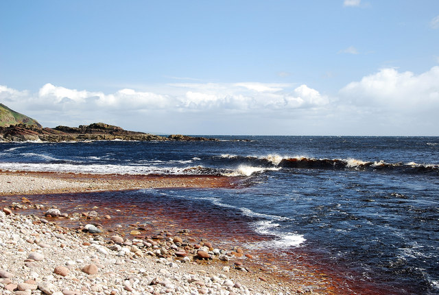
With its picturesque setting, Newport attracts visitors seeking tranquility and natural beauty. The village is known for its stunning sandy beach, which stretches for several miles and offers breathtaking views of the surrounding rugged landscapes. The beach is a popular spot for walkers, beachcombers, and birdwatchers, as it is home to a variety of bird species and marine life.

Newport itself is a charming and close-knit community, with a population of around 400 residents. The village features a handful of local amenities, including a small shop, a post office, and a pub, providing essential services for both residents and visitors. Despite its small size, Newport has a strong sense of community, with regular events and activities organized by local organizations and clubs.

The surrounding area offers a wealth of outdoor recreational opportunities, such as hiking, fishing, and cycling. Newport also serves as a convenient base for exploring the wider Caithness region, with its historic castles, ancient archaeological sites, and stunning natural landmarks like the Duncansby Stacks and the Castle of Mey.

Overall, Newport, Caithness, is a tranquil coastal village that offers a peaceful retreat for nature lovers and outdoor enthusiasts, while also providing a warm and welcoming community for its residents.

If you have any feedback on the listing, please let us know in the comments section below.

Newport Images

Images are sourced within 2km of 58.195299/-3.4886137 or Grid Reference ND1223. Thanks to Geograph Open Source API. All images are credited.

Burial ground amongst the whins Many graveyards in Northern Scotland overlook the sea or a loch. This one at Berriedale cuts a square out of the free flowering gorse (known as whins in this part of the world).
Burial ground amongst the whins
Many graveyards in Northern Scotland overlook the sea or a loch. This one at Berriedale cuts a square out of the free flowering gorse (known as whins in this part of the world).
Berriedale Beach Attractive stony beach where the peaty Waters of Langwell and Berriedale flow into the crystal clear sea waters.
Berriedale Beach
Attractive stony beach where the peaty Waters of Langwell and Berriedale flow into the crystal clear sea waters.
Woodland Walk Through the woods of Langwell to gain access to the open countryside.
Woodland Walk
Through the woods of Langwell to gain access to the open countryside.
Berriedale quay This old quay at Berriedale is still used occasionally. The aerial ropeway behind provides access to the cottages on the beach.
Berriedale quay
This old quay at Berriedale is still used occasionally. The aerial ropeway behind provides access to the cottages on the beach.
Berriedale Braes For traffic heading north for the first time drivers may find it a hair raising experience if they descend too fast.
Berriedale Braes
For traffic heading north for the first time drivers may find it a hair raising experience if they descend too fast.
Berriedale war memorial
Inver Hill A9 The track on the hill, along with the hillside and distant North Sea come to that are now all almost hidden by the trees that appear to have just been planted when we took this photo.
Inver Hill A9
The track on the hill, along with the hillside and distant North Sea come to that are now all almost hidden by the trees that appear to have just been planted when we took this photo.
Coastal view from the A9
Berriedale Bridge, Highland The view from the approach on the A9 from the north.
Berriedale Bridge, Highland
The view from the approach on the A9 from the north.
A9 through Berriedale
One of the Berriedale Navigation Beacon Towers Category B listed early 19th century beacon. These beacons appear to serve as navigation aids for safe entry into Berriedale shore when lined one against the other by boat at sea. They stand one behind the other on cliff top.
One of the Berriedale Navigation Beacon Towers
Category B listed early 19th century beacon. These beacons appear to serve as navigation aids for safe entry into Berriedale shore when lined one against the other by boat at sea. They stand one behind the other on cliff top.
Wind Damage in Berriedale
Locked Gate near Langwell Castle
Moss Covered Wall near Langwell House
Wind Damage in Berriedale The remains of several fallen trees on the driveway to Langwell House in Berriedale, County of Caithness.
Wind Damage in Berriedale
The remains of several fallen trees on the driveway to Langwell House in Berriedale, County of Caithness.
Langwell House The house is on a spur overlooking Berriedale.
Langwell House
The house is on a spur overlooking Berriedale.
Berriedale Braes A view to the north side of the infamous obstacle on the A9. I was told that Caithness is a flat county - other than the roads.

The bend on the north side makes the descent hazardous, and having this summer sampled the delights of Berriedale in both directions, I think I prefer travelling north. Either way it is hard work.
Berriedale Braes
A view to the north side of the infamous obstacle on the A9. I was told that Caithness is a flat county - other than the roads. The bend on the north side makes the descent hazardous, and having this summer sampled the delights of Berriedale in both directions, I think I prefer travelling north. Either way it is hard work.
Grippy road surface, Berriedale On the northbound climb of Berriedale Braes, the climb with the bends.  The grip enhanced surface ( I think it is gabbro) is starting to wear.
Grippy road surface, Berriedale
On the northbound climb of Berriedale Braes, the climb with the bends. The grip enhanced surface ( I think it is gabbro) is starting to wear.
Show me another place!

Newport is located at Grid Ref: ND1223 (Lat: 58.195299, Lng: -3.4886137)

Unitary Authority: Highland

Police Authority: Highlands and Islands

What 3 Words

///investor.stint.hopefully. Near Dunbeath, Highland

Related Wikis

Borgue, Highland

Borgue is a village in the historical county of Caithness, 3 miles (5 km) south of Dunbeath in the local authority are of Highland, Scotland.Rev Samuel...

Berriedale, Highland

Berriedale (Scottish Gaelic: Bearghdal) is a small estate village on the northern east coast of Caithness, Scotland, on the A9 road between Helmsdale and...

Berriedale Church

Berriedale Church is a former church in the parish of Latheron, in Berriedale, Caithness, Scotland. Built in 1826, the T-plan building was closed as a...

Newport, Caithness

Newport is a small remote village on the eastern shore of Caithness, Scottish Highlands and is in the Scottish council area of Highland.Ramscraig lies...

Berriedale Water

Berriedale Water is a short river in Caithness in northern Scotland. It arises as the Feith Gaineimh Mhor, Feith Chaorunn Mhor and Feith Fhuaran come together...

Berriedale Castle

Berriedale Castle is a ruined castle located on a promontory on the south of the entrance to the Berriedale Water, Caithness in Scotland. == Structure... ==

Ramscraig

Ramscraig is a small scattered crofting hamlet, located 2 miles southwest from Dunbeath, in eastern Caithness, Scottish Highlands and is in the Scottish...

Dunbeath air crash

The Dunbeath air crash involved the loss of a Short S.25 Sunderland Mk. III that crashed in the Scottish Highlands on a headland known as Eagle's Rock...

Nearby Amenities

Located within 500m of 58.195299,-3.4886137
Newport
Place: village
Lat/Long: 58.1982912/-3.4844143
Power: pole
Lat/Long: 58.1919142/-3.4939971
Power: pole
Lat/Long: 58.1925282/-3.4931656
Power: pole
Lat/Long: 58.1931974/-3.4922292
Power: pole
Lat/Long: 58.1938567/-3.4912966
Power: pole
Lat/Long: 58.1944134/-3.4905213
Power: pole
Lat/Long: 58.1951872/-3.4894838
Power: pole
Lat/Long: 58.1959777/-3.4883695
Power: pole
Lat/Long: 58.1966449/-3.4874463
Power: pole
Lat/Long: 58.1973871/-3.4864163
Power: pole
Lat/Long: 58.1983404/-3.4855904
Power: pole
Lat/Long: 58.1992769/-3.4847796
Power: pole
Lat/Long: 58.1929792/-3.4947705
Power: pole
Lat/Long: 58.1933405/-3.4960496
Power: pole
Lat/Long: 58.1958543/-3.4866972
Power: pole
Lat/Long: 58.1963083/-3.4866654
Power: pole
Lat/Long: 58.1966094/-3.4864613
Power: pole
Lat/Long: 58.196942/-3.4861972
Power: pole
Lat/Long: 58.1955859/-3.4853245
Passing Place
Lat/Long: 58.1964497/-3.4872472
The data included in this document is from www.openstreetmap.org. The data is made available under ODbL.

Have you been to Newport?

Leave your review of Newport below (or comments, questions and feedback).