Newport
Settlement in Yorkshire
England
Newport
Newport is a small village located in the county of Yorkshire, England. Situated in the district of East Riding of Yorkshire, it is nestled in the picturesque Yorkshire Wolds, surrounded by beautiful countryside and rolling hills. The village is part of the civil parish of Ellerton and has a population of around 200 residents.
Newport boasts a rich history that dates back to the medieval period. It is home to several historic buildings, including St. Peter's Church, a Grade II listed building that dates back to the 12th century. The church features stunning architecture and is a popular destination for history enthusiasts and tourists alike.
The village offers a tranquil and peaceful atmosphere, making it an ideal place to escape the hustle and bustle of city life. It provides a range of amenities for its residents, including a local pub and a village hall that hosts various community events throughout the year.
Surrounded by the stunning Yorkshire countryside, Newport offers plenty of opportunities for outdoor activities. The village is located close to the Yorkshire Wolds Way, a long-distance footpath that allows visitors to explore the beauty of the area on foot. Additionally, the nearby Humber Bridge provides easy access to the city of Hull and its amenities.
In conclusion, Newport is a charming village in the heart of Yorkshire that offers a combination of history, natural beauty, and a close-knit community. It is a place where residents and visitors can enjoy a peaceful and idyllic lifestyle surrounded by stunning landscapes.
If you have any feedback on the listing, please let us know in the comments section below.
Newport Images
Images are sourced within 2km of 54.571583/-1.254393 or Grid Reference NZ4819. Thanks to Geograph Open Source API. All images are credited.


Newport is located at Grid Ref: NZ4819 (Lat: 54.571583, Lng: -1.254393)
Division: North Riding
Unitary Authority: Middlesbrough
Police Authority: Cleveland
What 3 Words
///grips.dodges.reliving. Near Middlesbrough, North Yorkshire
Nearby Locations
Related Wikis

Newport railway station (S&D)
Newport railway station served the suburb of Newport, Borough of Middlesbrough, England, from 1830 to 1915 on the Middlesbrough branch of the Stockton...

Tees Newport Bridge
The Tees Newport Bridge is a vertical-lift bridge spanning the River Tees a short distance upriver from Tees Transporter Bridge, linking Middlesbrough...
Ayresome
Ayresome is an area of Middlesbrough, North Yorkshire, England. The settlement developed on West Lane and in some areas takes on the roads name. Most of...

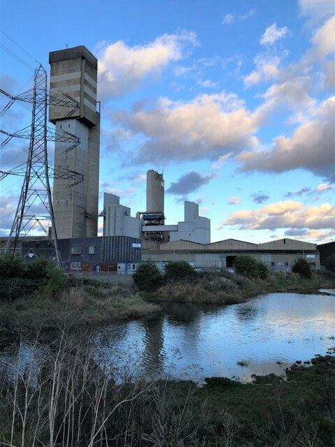
Portrack Incinerator
The Portrack Incinerator was a municipal waste incinerator and waste-to-energy power station situated on the River Tees at Portrack in Stockton-on-Tees...
Macmillan Academy
Macmillan Academy is an academy in Middlesbrough, North Yorkshire, England. The school was founded in 1989 as the Macmillan City Technology College, one...
The Northern School of Art
The Northern School of Art is a further and higher education art and design college, based in Middlesbrough and Hartlepool in the north-east of England...
Linthorpe Road
Linthorpe Road was a cricket and football ground in Middlesbrough in England. It was the home ground of Middlesbrough Cricket Club and Middlesbrough F...

Ayresome Park
Ayresome Park was a football stadium in the Ayresome area of Middlesbrough, North Yorkshire, England. It was the home of Middlesbrough F.C. from its construction...
Nearby Amenities
Located within 500m of 54.571583,-1.254393Have you been to Newport?
Leave your review of Newport below (or comments, questions and feedback).