Achuvoldrach

Settlement in Sutherland

Scotland

Achuvoldrach

Looking down on the causeway The causeway crosses the Kyle of Tongue. This picture was taken on the road from Melness and Talmine.
Looking down on the causeway Credit: Dorcas Sinclair

Achuvoldrach is a small rural hamlet located in the county of Sutherland, in the northernmost part of the Scottish Highlands. Situated amidst stunning natural beauty, this peaceful village is nestled between rolling hills and picturesque landscapes. Achuvoldrach is approximately 10 miles southeast of the town of Dornoch.

The main feature of Achuvoldrach is its charming collection of traditional Scottish cottages, which add to the village's quaint and idyllic atmosphere. The cottages are predominantly made from local stone and have thatched roofs, giving them a distinctive character. The village is surrounded by lush green pastures and is dotted with sheep farms, adding to its rural charm.

The community in Achuvoldrach is close-knit, with a population of around 100 residents. The village is known for its friendly and welcoming atmosphere, making it a desirable place for those seeking a peaceful and tranquil lifestyle.

For outdoor enthusiasts, Achuvoldrach offers plenty of opportunities for exploration and recreation. The surrounding area is a haven for hikers and nature lovers, with numerous walking trails and scenic viewpoints to discover. The nearby Loch Achuvoldrach is also a popular spot for fishing and boating.

Although Achuvoldrach is a small village, it benefits from its proximity to larger towns such as Dornoch, which provides essential amenities like shops, schools, and healthcare services. Overall, Achuvoldrach is an enchanting rural retreat, offering a peaceful escape in the heart of the Scottish Highlands.

If you have any feedback on the listing, please let us know in the comments section below.

Achuvoldrach Images

Images are sourced within 2km of 58.496649/-4.459685 or Grid Reference NC5659. Thanks to Geograph Open Source API. All images are credited.

Looking down on the causeway The causeway crosses the Kyle of Tongue. This picture was taken on the road from Melness and Talmine.
Looking down on the causeway
The causeway crosses the Kyle of Tongue. This picture was taken on the road from Melness and Talmine.
Loch a' Mhuillin track Track up on to the moors, now signposted. Many communities in Scotland are signposting paths, there being a perception that Scotland is only a place for big hill walks. Paths like this broaden the appeal of walking to those wanting a less strenuous or time consuming trip.
Loch a' Mhuillin track
Track up on to the moors, now signposted. Many communities in Scotland are signposting paths, there being a perception that Scotland is only a place for big hill walks. Paths like this broaden the appeal of walking to those wanting a less strenuous or time consuming trip.
An Dubh-loch
An Dubh-loch
Fields on shoreline of Kyle of Tongue, Scotland Sheep grazing in these small fields by the shoreline of the Kyle of Tongue on the road from Talmine.  Large thistle on the right hand side of the image.  Looking across we can see the bridge across the Kyle of Tongue on the right and Ben Loyal on the horizon on the left of the image.
Fields on shoreline of Kyle of Tongue, Scotland
Sheep grazing in these small fields by the shoreline of the Kyle of Tongue on the road from Talmine. Large thistle on the right hand side of the image. Looking across we can see the bridge across the Kyle of Tongue on the right and Ben Loyal on the horizon on the left of the image.
Towards the Kyle of Tongue Almost high tide in the kyle. Always an impressive place.
Towards the Kyle of Tongue
Almost high tide in the kyle. Always an impressive place.
Southern side of Tongue Causeway The causeway that carries the road across the Kyle of Tongue.
Southern side of Tongue Causeway
The causeway that carries the road across the Kyle of Tongue.
Slipway on the Kyle of Tongue Causeway
Jetty and tidal rocks by Kyle of Tongue
Junction with A838
Junction with A838
Melness burial ground
Kyle of Tongue picnic area
Tongue Causeway Monument The plaque reads: 'Kyle of Tongue Crossing. This crossing was opened on Friday 3rd September 1971.' Ben Loyal is in the background.
Tongue Causeway Monument
The plaque reads: 'Kyle of Tongue Crossing. This crossing was opened on Friday 3rd September 1971.' Ben Loyal is in the background.
Kyle of Tongue and bridge Looking south-eastwards towards the Tongue bridge, with Ben Loyal in the distance.
Kyle of Tongue and bridge
Looking south-eastwards towards the Tongue bridge, with Ben Loyal in the distance.
Kyle of Tongue: fisherman Taken from the causeway. The fisherman had a heron-like stillness and intensity.
Ben Loyal provides the backdrop.
Kyle of Tongue: fisherman
Taken from the causeway. The fisherman had a heron-like stillness and intensity. Ben Loyal provides the backdrop.
Loch A' Mhuillin A loch on the Moine close to Melness.
Loch A' Mhuillin
A loch on the Moine close to Melness.
Loch A' Mhuilinn A loch on the Moine, with Ben Loyal in the distance.
Loch A' Mhuilinn
A loch on the Moine, with Ben Loyal in the distance.
A pool on the Moine A dubh lochan.
A pool on the Moine
A dubh lochan.
An Dubh-Loch A loch on the Moine.
An Dubh-Loch
A loch on the Moine.
Show me another place!

Achuvoldrach is located at Grid Ref: NC5659 (Lat: 58.496649, Lng: -4.459685)

Unitary Authority: Highland

Police Authority: Highlands and Islands

What 3 Words

///wiggly.processor.mixing. Near Altnaharra, Highland

Nearby Locations

Achuvoldrach

Related Wikis

Achuvoldrach

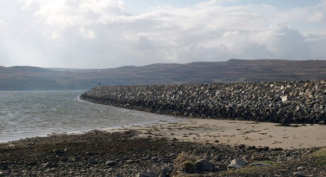
Achuvoldrach (Scottish Gaelic: Achadh a’ Mholltairich) is a small remote village on the west shore of the Kyle of Tongue in Sutherland, in the Highland...
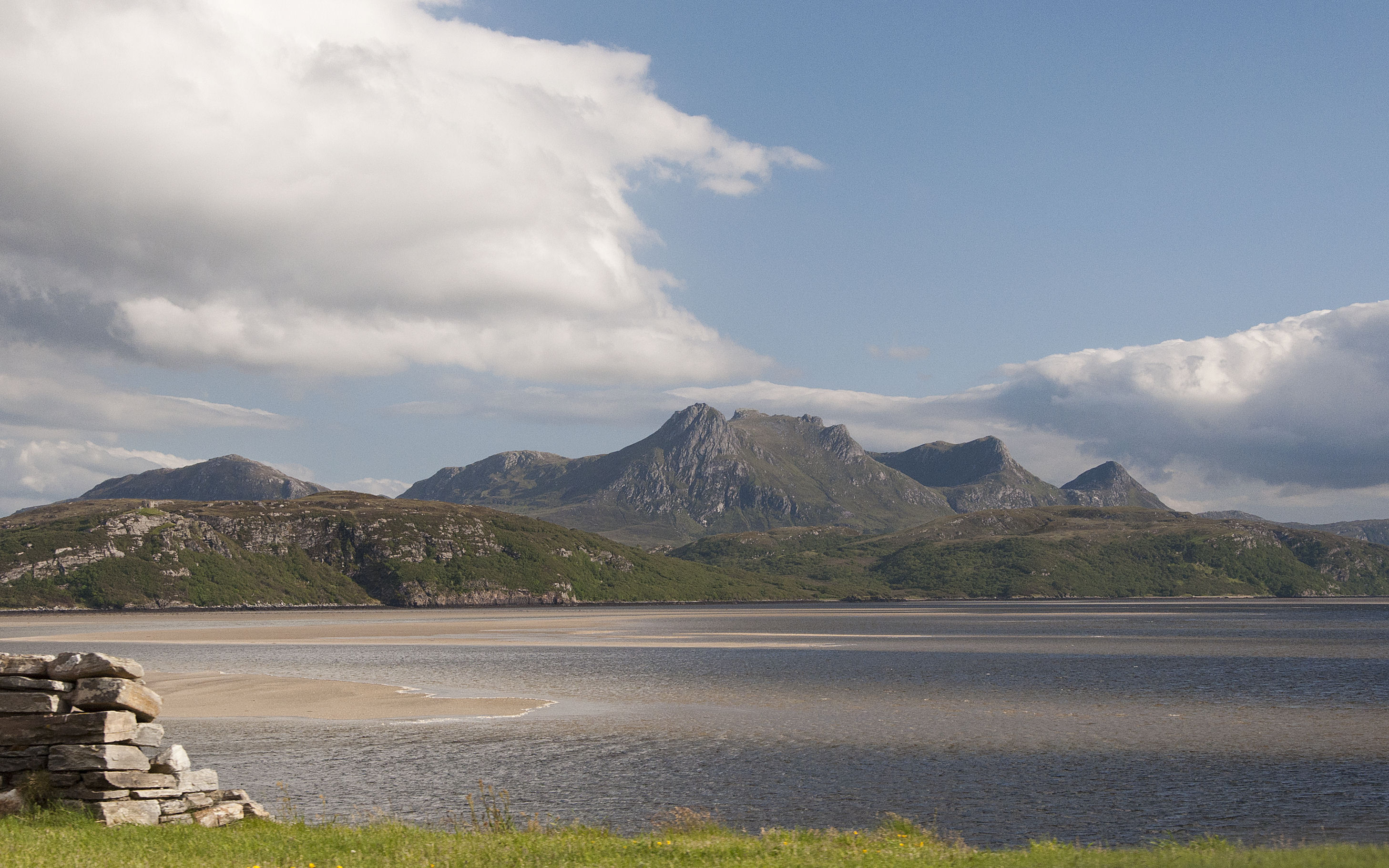
Kyle of Tongue

The Kyle of Tongue (Scottish Gaelic: Caol Thunga) is a shallow sea loch in northwest Highland, Scotland, in the western part of Sutherland. Featuring a...
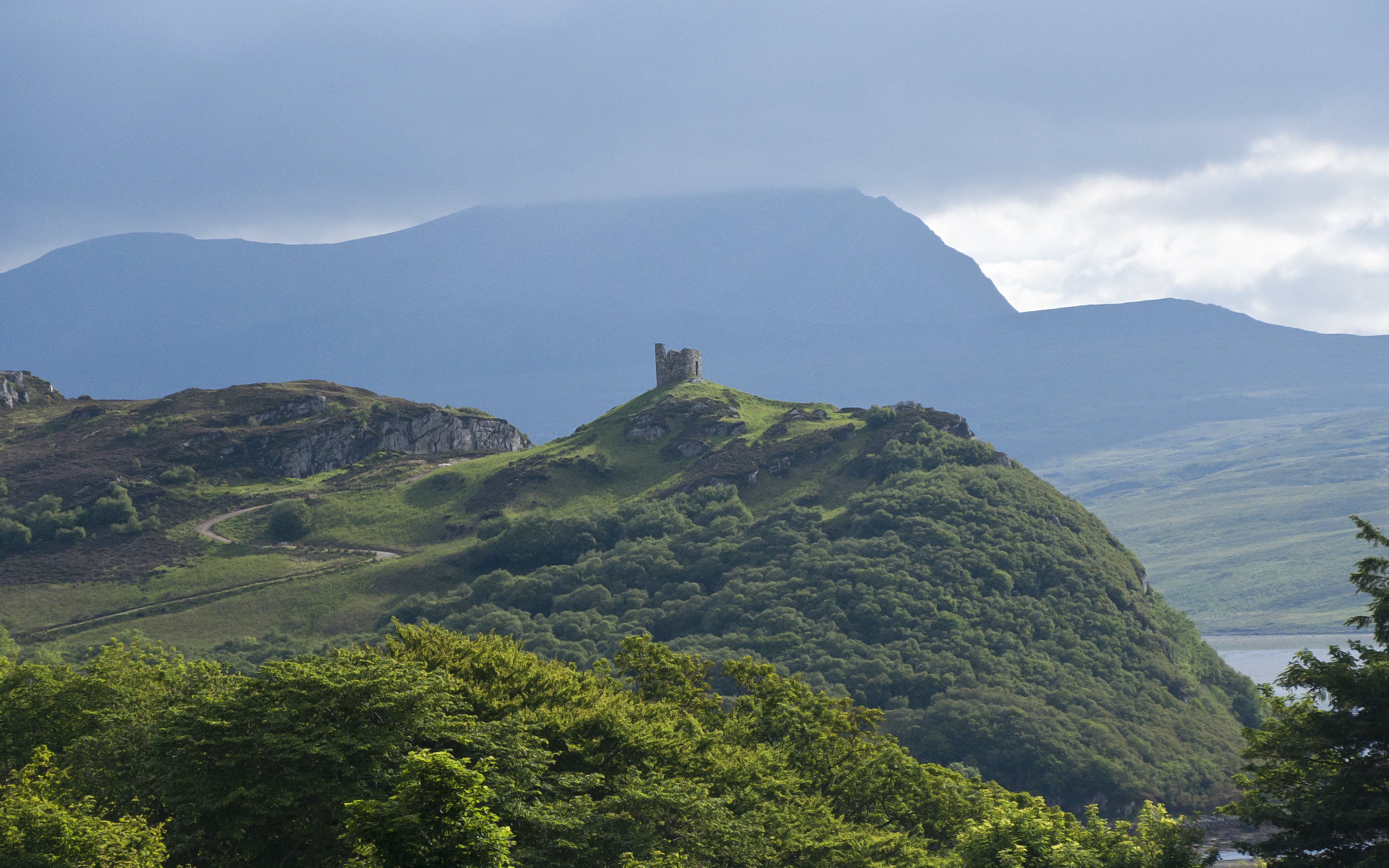
Castle Varrich

Castle Varrich (Scottish Gaelic: Caisteal Bharraich) is a castle in the far north of the Scottish Highlands, near the village of Tongue. The castle is...

Braetongue

Braetongue (Scottish Gaelic: Bràigh Thunga) is an area in northern Sutherland just north of the town of Tongue (grid ref. NC595572). Runrig mentions the...

Nearby Amenities

Located within 500m of 58.496649,-4.459685
Source: PGS
Lat/Long: 58.4927307/-4.4559956
Source: PGS
Lat/Long: 58.4943715/-4.4560775
Source: PGS
Lat/Long: 58.4946394/-4.45578
Source: PGS
Lat/Long: 58.4954692/-4.4547891
Source: PGS
Lat/Long: 58.4960769/-4.4545963
Source: PGS
Lat/Long: 58.4962655/-4.4542975
Source: PGS
Lat/Long: 58.4957142/-4.4523412
Source: PGS
Lat/Long: 58.4965001/-4.4530715
Passing Place
Lat/Long: 58.493709/-4.4565118
Passing Place
Lat/Long: 58.4943084/-4.4564228
Passing Place
Lat/Long: 58.4961418/-4.4595039
Passing Place
Lat/Long: 58.4933332/-4.4565493
Bus Stop
Lat/Long: 58.4966993/-4.4554704
Power: pole
Lat/Long: 58.4933027/-4.4578219
Power: pole
Lat/Long: 58.493823/-4.4583436
Power: pole
Lat/Long: 58.4942178/-4.4587369
Power: pole
Lat/Long: 58.4949869/-4.4593948
Power: pole
Lat/Long: 58.4951883/-4.4596615
Power: pole
Lat/Long: 58.4957213/-4.4602203
Power: pole
Lat/Long: 58.4962513/-4.4607264
Achuvoldrach
Place: locality
Source Name: os_opendata_streetview
Lat/Long: 58.4945965/-4.4571286
Passing Place
Lat/Long: 58.4946624/-4.4576892
Passing Place
Lat/Long: 58.4968013/-4.4596285
Barrier: cattle_grid
Lat/Long: 58.4965667/-4.4538201
The data included in this document is from www.openstreetmap.org. The data is made available under ODbL.

Have you been to Achuvoldrach?

Leave your review of Achuvoldrach below (or comments, questions and feedback).