Benson

Settlement in Oxfordshire South Oxfordshire

England

Benson

The Stables, Howbery Park Some of the distinctive original Victorian buildings from the short lived country house and park at Howbery Manor. Local MP William Seymour Blackstone had the place built in the 1850s but ran out of money and never got to live here.
Subsequently taken over in the mid 20th century and turned into a science park, the estate is now a strange mix of decorative Victorian, including the Manor House <a href="https://www.geograph.org.uk/photo/1336605">SU6190 : Howbery Park house</a> together with utilitarian blocks from the 50s and 60s, assorted portacabins, and two environmentally sound office developments from this century.
The Stables have long been in office use.
The Stables, Howbery Park Credit: Des Blenkinsopp

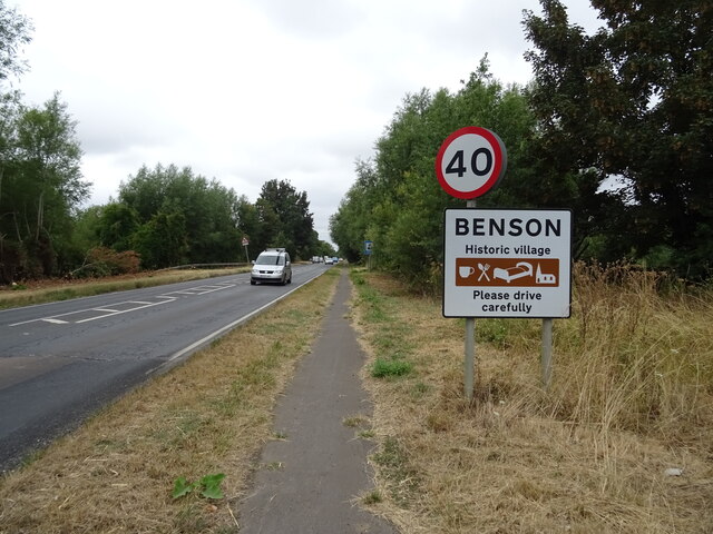
Benson is a charming village located in the county of Oxfordshire, England. Situated about 10 miles south of the historic city of Oxford, it falls within the district of South Oxfordshire. With a population of around 4,800 residents, Benson exudes a close-knit community feel.

The village is renowned for its picturesque setting, surrounded by the beautiful countryside of the Thames Valley. It lies on the eastern bank of the River Thames, providing stunning views and opportunities for leisurely walks along the riverbank.

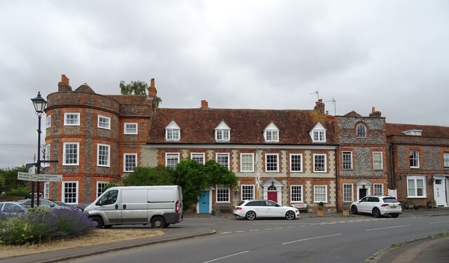
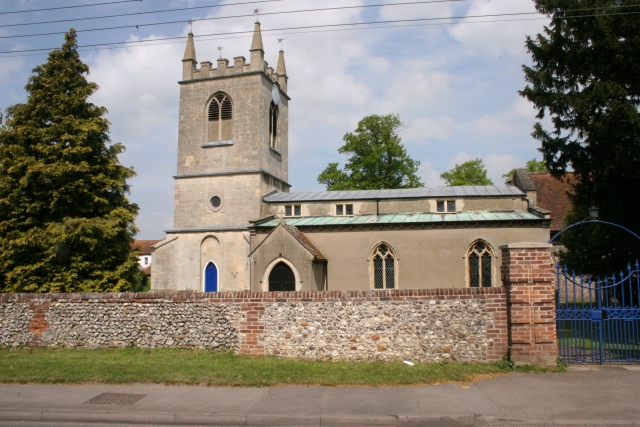
Benson has a rich history, with evidence of settlements dating back to the Bronze Age. The village was mentioned in the Domesday Book of 1086, highlighting its long-standing significance. Over the years, it has thrived as an agricultural community, with farming playing a vital role in its economy.

Today, Benson offers a range of amenities and services to its residents. The village has a primary school, a library, a post office, and a health center, ensuring that the needs of the local community are well catered to. Additionally, there are several shops, pubs, and restaurants that contribute to the village's vibrant atmosphere.

Aviation enthusiasts will also find Benson of particular interest, as it is home to the Royal Air Force Benson. This military airbase has been in operation since World War II and continues to serve as a training and support hub for the RAF.

Overall, Benson is a delightful village that seamlessly combines its rich heritage with a modern lifestyle. Its idyllic location, friendly community, and range of amenities make it an appealing place to live or visit.

If you have any feedback on the listing, please let us know in the comments section below.

Benson Images

Images are sourced within 2km of 51.620956/-1.107204 or Grid Reference SU6191. Thanks to Geograph Open Source API. All images are credited.

The Stables, Howbery Park Some of the distinctive original Victorian buildings from the short lived country house and park at Howbery Manor. Local MP William Seymour Blackstone had the place built in the 1850s but ran out of money and never got to live here.
Subsequently taken over in the mid 20th century and turned into a science park, the estate is now a strange mix of decorative Victorian, including the Manor House <a href="https://www.geograph.org.uk/photo/1336605">SU6190 : Howbery Park house</a> together with utilitarian blocks from the 50s and 60s, assorted portacabins, and two environmentally sound office developments from this century.
The Stables have long been in office use.
The Stables, Howbery Park
Some of the distinctive original Victorian buildings from the short lived country house and park at Howbery Manor. Local MP William Seymour Blackstone had the place built in the 1850s but ran out of money and never got to live here. Subsequently taken over in the mid 20th century and turned into a science park, the estate is now a strange mix of decorative Victorian, including the Manor House SU6190 : Howbery Park house together with utilitarian blocks from the 50s and 60s, assorted portacabins, and two environmentally sound office developments from this century. The Stables have long been in office use.
Avenue at Howbery Park A pleasant tree lined drive and Victorian buildings from the short lived country house and park at Howbery Manor. Local MP William Seymour Blackstone had the place built in the 1850s but ran out of money and never got to live here.
Subsequently taken over in the mid 20th century and turned into a science park, the estate is now a strange mix of original Victorian, utilitarian blocks from the 50s and 60s, assorted portacabins, and two environmentally sound office developments from this century.
Avenue at Howbery Park
A pleasant tree lined drive and Victorian buildings from the short lived country house and park at Howbery Manor. Local MP William Seymour Blackstone had the place built in the 1850s but ran out of money and never got to live here. Subsequently taken over in the mid 20th century and turned into a science park, the estate is now a strange mix of original Victorian, utilitarian blocks from the 50s and 60s, assorted portacabins, and two environmentally sound office developments from this century.
Wallingford Waste Facility
Gated track near Wallingford Waste Facility
A4074 towards Oxford
Footpath to Benson Off the A4074.
Footpath to Benson
Off the A4074.
A4074, Benson Towards Oxford.
A4074, Benson
Towards Oxford.
Entering Benson On the A4074.
Entering Benson
On the A4074.
St. Helen's Church, Benson
War Memorial, Benson
Castle Square, Benson
Cottages on High Street, Benson
The Crown Public house, Benson On High Street.
See <a href="https://www.geograph.org.uk/photo/7247124">SU6291 : Sign for the Crown Public house, Benson</a> for sign.
The Crown Public house, Benson
On High Street. See SU6291 : Sign for the Crown Public house, Benson for sign.
The Crown Public house, Benson On High Street.
See <a href="https://www.geograph.org.uk/photo/7247124">SU6291 : Sign for the Crown Public house, Benson</a> for sign.
The Crown Public house, Benson
On High Street. See SU6291 : Sign for the Crown Public house, Benson for sign.
Sign for the Crown Public house, Benson See <a href="https://www.geograph.org.uk/photo/7247122">SU6291 : The Crown Public house, Benson</a> and <a href="https://www.geograph.org.uk/photo/7247123">SU6291 : The Crown Public house, Benson</a> for context.
Sign for the Crown Public house, Benson
Cottages on Brook Street, Benson
Brook Street, Benson
Thatched cottage on Brook Street, Benson
Show me another place!

Benson is located at Grid Ref: SU6191 (Lat: 51.620956, Lng: -1.107204)

Administrative County: Oxfordshire

District: South Oxfordshire

Police Authority: Thames Valley

What 3 Words

///baker.hood.yards. Near Benson, Oxfordshire

Related Wikis

Benson, Oxfordshire

Benson is a village and civil parish in South Oxfordshire, England. The 2011 Census gave the parish population as 4,754. It lies about a mile and a half...

Benson Veteran Cycle Museum

Benson Veteran Cycle Museum is a private museum of veteran cycles in the village of Benson near Wallingford in Oxfordshire, England.The museum has over...
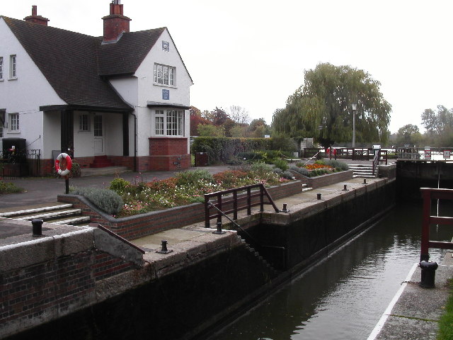
Benson Lock

Benson Lock is a lock on the River Thames in England, close to Benson, Oxfordshire but on the opposite bank of the river. The first pound lock here was...

Preston Crowmarsh

Preston Crowmarsh is a hamlet in Benson civil parish in South Oxfordshire. It is on the River Thames 1 mile (1.6 km) north of Wallingford. The river can...
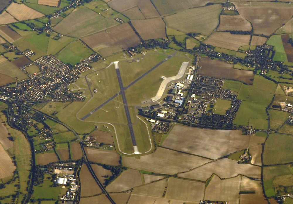
RAF Benson

Royal Air Force Benson or RAF Benson (IATA: BEX, ICAO: EGUB) is a Royal Air Force (RAF) station located at Benson, near Wallingford, in South Oxfordshire...
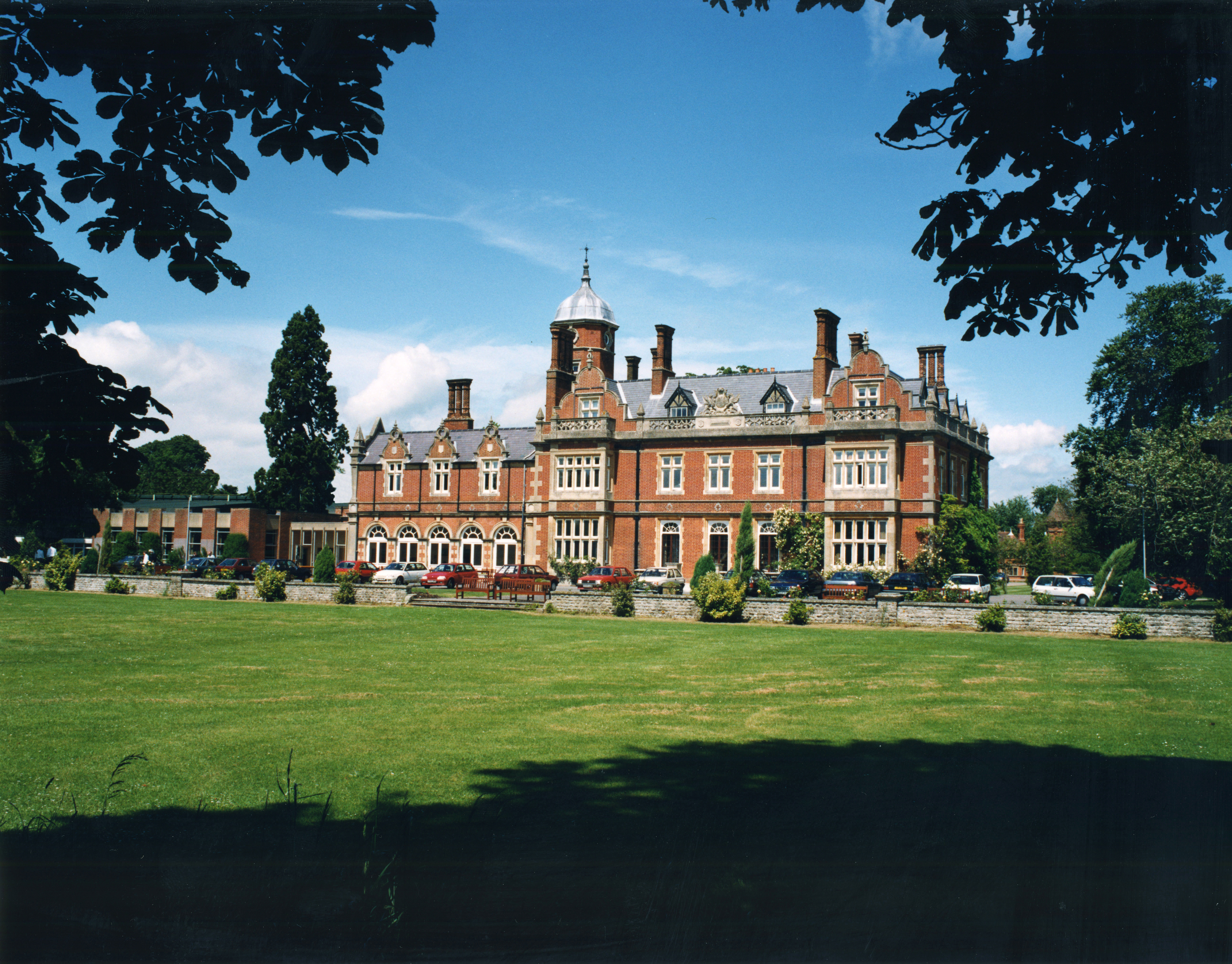
Howbery Park

Howbery Park is a 36-ha park located adjacent to the River Thames in Crowmarsh Gifford near Wallingford, UK. Its main feature is an English manor house...

A4074 road

The A4074 is a British A road from the Reading suburb of Caversham to the Heyford Hill roundabout on the Oxford Ring Road.The road starts from a junction...

Roke

Roke is a hamlet in South Oxfordshire, about 3 miles (4.8 km) north of Wallingford. It has a sixteenth-century public house, the Home Sweet Home. It is...

Nearby Amenities

Located within 500m of 51.620956,-1.107204
Turning Circle
Turning Circle: hammer
Lat/Long: 51.6229785/-1.1058119
Bus Stop
High Street
Bus: yes
Naptan AtcoCode: 340000087HS
Naptan Bearing: W
Naptan CommonName: High Street
Naptan Indicator: o/s Post Office
Naptan Landmark: Opp Bus Shelter
Naptan NaptanCode: oxfampwg
Naptan Street: High Street
Naptan Verified: no
Public Transport: platform
Source: naptan_import
Lat/Long: 51.6211177/-1.1063159
Bus Stop
High Street
Bus: yes
Naptan AtcoCode: 340000087HSS
Naptan Bearing: E
Naptan CommonName: High Street
Naptan Indicator: Opp Post Office
Naptan Landmark: Bus Shelter
Naptan NaptanCode: oxfgjtwg
Naptan Street: High Street
Naptan Verified: no
Public Transport: platform
Shelter: yes
Source: naptan_import
Lat/Long: 51.6211001/-1.1068609
St Helens Cresent
Naptan AtcoCode: 340001486EAS
Naptan Bearing: E
Naptan BusStopType: CUS
Naptan CommonName: St Helens Cresent
Naptan Indicator: Corner
Naptan Landmark: St Helens Crescent
Naptan NaptanCode: oxfagpdw
Naptan Street: St Helens Avenue
Naptan Verified: no
Source: naptan_import
Lat/Long: 51.6177792/-1.1059915
Bus Stop
St Helens Cresent
Bus: yes
Naptan AtcoCode: 340001486WES
Naptan Bearing: W
Naptan CommonName: St Helens Cresent
Naptan Indicator: Opposite
Naptan Landmark: St Helens Crescent
Naptan NaptanCode: oxfagpdt
Naptan Street: St Helens Avenue
Naptan Verified: no
Public Transport: platform
Source: naptan_import
Lat/Long: 51.6177094/-1.1062673
Old London Road
Naptan AtcoCode: 340001488NOR
Naptan Bearing: N
Naptan BusStopType: CUS
Naptan CommonName: Old London Road
Naptan Indicator: Northbound
Naptan Landmark: No 8
Naptan NaptanCode: oxfagpwt
Naptan Street: Old London Road
Naptan Verified: no
Source: naptan_import
Lat/Long: 51.6184163/-1.1034512
Bus Stop
Old London Road
Bus: yes
Naptan AtcoCode: 340001488SOU
Naptan Bearing: S
Naptan CommonName: Old London Road
Naptan Indicator: Southbound
Naptan Landmark: No 8
Naptan NaptanCode: oxfagtag
Naptan Street: Old London Road
Naptan Verified: no
Public Transport: platform
Source: naptan_import
Lat/Long: 51.6184591/-1.1033222
Bus Stop
Horseshoes Lane
Bus: yes
Naptan AtcoCode: 340001489CNR
Naptan Bearing: SE
Naptan CommonName: Horseshoes Lane
Naptan Indicator: Corner
Naptan Landmark: Horseshoes Lane
Naptan NaptanCode: oxfagpjg
Naptan Notes: Pole Only
Naptan Street: Oxford Road
Naptan Verified: no
Public Transport: platform
Shelter: no
Source: naptan_import
Lat/Long: 51.6212397/-1.1120369
Bus Stop
Horseshoes Lane
Bus: yes
Naptan AtcoCode: 340001489OPP
Naptan Bearing: NW
Naptan CommonName: Horseshoes Lane
Naptan Indicator: Opposite
Naptan Landmark: Horseshoes Lane
Naptan NaptanCode: oxfagtdt
Naptan Street: Oxford Road
Naptan Verified: no
Public Transport: platform
Source: naptan_import
Lat/Long: 51.6210539/-1.1116681
Sands Way
Naptan AtcoCode: 340003042OPP
Naptan Bearing: SW
Naptan BusStopType: CUS
Naptan CommonName: Sands Way
Naptan Indicator: Opposite
Naptan Landmark: Sands Way
Naptan NaptanCode: oxfawdag
Naptan Street: Watlington Road
Naptan Verified: no
Source: naptan_import
Lat/Long: 51.6252141/-1.1058165
Sands Way
Naptan AtcoCode: 340003042OUT
Naptan Bearing: NE
Naptan BusStopType: CUS
Naptan CommonName: Sands Way
Naptan Indicator: Outside
Naptan Landmark: Sands Way
Naptan NaptanCode: oxfawdaj
Naptan Street: Watlington Road
Naptan Verified: no
Source: naptan_import
Lat/Long: 51.6252685/-1.1058732
Bus Stop
Church Road
Bus: yes
Naptan AtcoCode: 340004129CHO
Naptan Bearing: E
Naptan CommonName: Church Road
Naptan Indicator: Eastbound
Naptan Landmark: Church Close
Naptan NaptanCode: oxfgpamt
Naptan ShortCommonName: Church Road
Naptan Street: Church Road
Naptan Verified: no
Public Transport: platform
Source: naptan_import
Lat/Long: 51.6195379/-1.1138005
Bus Stop
Church Road
Bus: yes
Naptan AtcoCode: 340004129CHU
Naptan Bearing: W
Naptan CommonName: Church Road
Naptan Indicator: Corner
Naptan Landmark: Church Close
Naptan NaptanCode: oxfgpamw
Naptan Street: Church Road
Naptan Verified: no
Public Transport: platform
Source: naptan_import
Lat/Long: 51.6195983/-1.1134671
Bus Stop
Blacklands Road
Bus: yes
Naptan AtcoCode: 340004148CNR
Naptan Bearing: NE
Naptan CommonName: Blacklands Road
Naptan Crossing: Blacklands Road
Naptan Indicator: Corner
Naptan Landmark: Electricity Sub Station
Naptan NaptanCode: oxfgpamg
Naptan ShortCommonName: Blacklands Road
Naptan Street: Brook Street
Naptan Verified: no
Public Transport: platform
Source: naptan_import
Lat/Long: 51.6222056/-1.1027698
Bus Stop
Blacklands Road
Bus: yes
Naptan AtcoCode: 340004148OPP
Naptan Bearing: SW
Naptan CommonName: Blacklands Road
Naptan Crossing: Old Barn Close
Naptan Indicator: Opposite
Naptan Landmark: Old Barn Close
Naptan NaptanCode: oxfgpamj
Naptan ShortCommonName: Blacklands Road
Naptan Street: Brook Street
Naptan Verified: no
Public Transport: platform
Source: naptan_import
Lat/Long: 51.6220977/-1.102772
Turning Circle
Turning Circle: square
Lat/Long: 51.621951/-1.105342
Turning Circle
Turning Circle: square
Lat/Long: 51.6237747/-1.10433
Turning Circle
Turning Circle: circle
Lat/Long: 51.6241555/-1.1071718
Turning Circle
Lat/Long: 51.621284/-1.1022536
Turning Circle
Turning Circle: hammer
Lat/Long: 51.6215716/-1.1024771
Turning Circle
Turning Circle: y-head
Lat/Long: 51.6251143/-1.1071824
Turning Circle
Turning Circle: hammer
Lat/Long: 51.6185896/-1.1061247
Turning Circle
Turning Circle: square
Lat/Long: 51.6192156/-1.1059251
Turning Circle
Turning Circle: hammer
Lat/Long: 51.6204779/-1.1039995
Turning Circle
Turning Circle: y-head
Lat/Long: 51.6216028/-1.1104737
Benson
Place: village
Wikidata: Q2351343
Wikipedia: en:Benson, Oxfordshire
Lat/Long: 51.6211826/-1.1084793
Chiltern Florist
Shop: greengrocer
Lat/Long: 51.6211608/-1.1072336
Fast Food
The Village Plaice
Cuisine: fish_and_chips
Lat/Long: 51.6212974/-1.1061674
Derry's Den
Shop: gift
Lat/Long: 51.6209554/-1.1068634
Shop: hairdresser
Lat/Long: 51.6211758/-1.1071062
Bench
Backrest: yes
Material: metal
Lat/Long: 51.6224184/-1.1023145
Barrier: kissing_gate
Bicycle: no
Foot: yes
Lat/Long: 51.6173662/-1.1108785
Barrier: kissing_gate
Bicycle: no
Foot: yes
Lat/Long: 51.6173684/-1.110869
Barrier: cycle_barrier
Bicycle: no
Foot: yes
Lat/Long: 51.6212968/-1.1119514
Traffic Calming: choker
Lat/Long: 51.6226436/-1.11155
Turning Circle
Turning Circle: knuckle
Lat/Long: 51.6236456/-1.1106045
Give Way
Direction: forward
Lat/Long: 51.6227223/-1.1100516
Defibrillator
Emergency: defibrillator
Indoor: no
Lat/Long: 51.6210972/-1.106923
Benson War Memorial
Historic: memorial
Material: stone
Memorial: war_memorial
Wikidata: Q26677353
Lat/Long: 51.6207914/-1.1108407
Waste Basket
Lat/Long: 51.6210847/-1.1070069
Give Way
Direction: backward
Lat/Long: 51.6226552/-1.1114672
Traffic Calming: choker
Lat/Long: 51.6227152/-1.109768
Direction: 235
Generator Method: photovoltaic
Generator Output Electricity: yes
Generator Solar Modules: 18
Generator Source: solar
Generator Type: solar_photovoltaic_panel
Location: roof
Power: generator
Lat/Long: 51.619606/-1.112394
Direction: 230
Generator Method: photovoltaic
Generator Output Electricity: yes
Generator Solar Modules: 12
Generator Source: solar
Generator Type: solar_photovoltaic_panel
Location: roof
Power: generator
Lat/Long: 51.6192868/-1.1093027
Direction: 230
Generator Method: photovoltaic
Generator Output Electricity: yes
Generator Solar Modules: 9
Generator Source: solar
Generator Type: solar_photovoltaic_panel
Location: roof
Power: generator
Lat/Long: 51.6193534/-1.1092037
Direction: 195
Generator Method: photovoltaic
Generator Output Electricity: yes
Generator Solar Modules: 15
Generator Source: solar
Generator Type: solar_photovoltaic_panel
Location: roof
Power: generator
Lat/Long: 51.6183631/-1.1086194
Fixme: solar panels?
Lat/Long: 51.6184702/-1.1028799
Fixme: solar panels?
Lat/Long: 51.6185383/-1.1038738
Direction: 235
Generator Method: photovoltaic
Generator Output Electricity: yes
Generator Solar Modules: 12
Generator Source: solar
Generator Type: solar_photovoltaic_panel
Location: roof
Power: generator
Lat/Long: 51.6194033/-1.1047141
Generator Method: photovoltaic
Generator Output Electricity: yes
Generator Solar Modules: 8
Generator Source: solar
Generator Type: solar_photovoltaic_panel
Location: roof
Power: generator
Tilted: no
Lat/Long: 51.6182635/-1.1057767
Direction: 190
Generator Method: photovoltaic
Generator Output Electricity: yes
Generator Solar Modules: 8
Generator Source: solar
Generator Type: solar_photovoltaic_panel
Location: roof
Power: generator
Lat/Long: 51.6182494/-1.105869
Direction: 280
Generator Method: photovoltaic
Generator Output Electricity: yes
Generator Solar Modules: 15
Generator Source: solar
Generator Type: solar_photovoltaic_panel
Location: roof
Power: generator
Lat/Long: 51.6182874/-1.1059015
Direction: 130
Generator Method: photovoltaic
Generator Output Electricity: yes
Generator Solar Modules: 16
Generator Source: solar
Generator Type: solar_photovoltaic_panel
Location: roof
Power: generator
Lat/Long: 51.6186934/-1.1056099
Fixme: solar panels?
Lat/Long: 51.6190681/-1.1071791
Direction: 235
Generator Method: photovoltaic
Generator Output Electricity: yes
Generator Solar Modules: 18
Generator Source: solar
Generator Type: solar_photovoltaic_panel
Location: roof
Power: generator
Lat/Long: 51.6197948/-1.1136597
Direction: 240
Fixme: survey for panel count
Generator Method: photovoltaic
Generator Output Electricity: yes
Generator Solar Modules: 18
Generator Source: solar
Generator Type: solar_photovoltaic_panel
Location: roof
Power: generator
Lat/Long: 51.6202716/-1.1113379
Give Way
Direction: backward
Lat/Long: 51.6210362/-1.1096804
Give Way
Direction: forward
Lat/Long: 51.621062/-1.1100132
Direction: 150
Generator Method: photovoltaic
Generator Output Electricity: yes
Generator Solar Modules: 10
Generator Source: solar
Generator Type: solar_photovoltaic_panel
Location: roof
Power: generator
Lat/Long: 51.6201324/-1.1086542
Direction: 140
Generator Method: photovoltaic
Generator Output Electricity: yes
Generator Solar Modules: 14
Generator Source: solar
Generator Type: solar_photovoltaic_panel
Location: roof
Power: generator
Lat/Long: 51.6212149/-1.101977
Direction: 150
Generator Method: photovoltaic
Generator Output Electricity: yes
Generator Solar Modules: 8
Generator Source: solar
Generator Type: solar_photovoltaic_panel
Location: roof
Power: generator
Lat/Long: 51.6221144/-1.1023106
Direction: 240
Generator Method: photovoltaic
Generator Output Electricity: yes
Generator Solar Modules: 10
Generator Source: solar
Generator Type: solar_photovoltaic_panel
Location: roof
Power: generator
Lat/Long: 51.6220899/-1.1024232
Direction: 150
Generator Method: photovoltaic
Generator Output Electricity: yes
Generator Solar Modules: 18
Generator Source: solar
Generator Type: solar_photovoltaic_panel
Location: roof
Power: generator
Lat/Long: 51.622323/-1.1003575
Direction: 150
Generator Method: photovoltaic
Generator Output Electricity: yes
Generator Solar Modules: 16
Generator Source: solar
Generator Type: solar_photovoltaic_panel
Location: roof
Power: generator
Lat/Long: 51.6215743/-1.1109671
Direction: 145
Generator Method: photovoltaic
Generator Output Electricity: yes
Generator Solar Modules: 3
Generator Source: solar
Generator Type: solar_photovoltaic_panel
Location: roof
Power: generator
Lat/Long: 51.6220291/-1.1093588
Direction: 145
Generator Method: photovoltaic
Generator Output Electricity: yes
Generator Solar Modules: 3
Generator Source: solar
Generator Type: solar_photovoltaic_panel
Location: roof
Power: generator
Lat/Long: 51.6220459/-1.1093218
Direction: 235
Generator Method: photovoltaic
Generator Output Electricity: yes
Generator Solar Modules: 12
Generator Source: solar
Generator Type: solar_photovoltaic_panel
Location: roof
Power: generator
Lat/Long: 51.6221745/-1.1089332
Turning Circle
Turning Circle: knuckle
Lat/Long: 51.621998/-1.1091045
Turning Circle
Turning Circle: knuckle
Lat/Long: 51.6216843/-1.1091766
Direction: 150
Generator Method: photovoltaic
Generator Output Electricity: yes
Generator Solar Modules: 20
Generator Source: solar
Generator Type: solar_photovoltaic_panel
Location: roof
Power: generator
Lat/Long: 51.622408/-1.1065267
Direction: 145
Generator Method: photovoltaic
Generator Output Electricity: yes
Generator Solar Modules: 15
Generator Source: solar
Generator Type: solar_photovoltaic_panel
Location: roof
Power: generator
Lat/Long: 51.6225365/-1.1068739
Direction: 240
Generator Method: photovoltaic
Generator Output Electricity: yes
Generator Solar Modules: 12
Generator Source: solar
Generator Type: solar_photovoltaic_panel
Location: roof
Power: generator
Lat/Long: 51.6228054/-1.1046604
Direction: 240
Generator Method: photovoltaic
Generator Output Electricity: yes
Generator Solar Modules: 18
Generator Source: solar
Generator Type: solar_photovoltaic_panel
Location: roof
Power: generator
Lat/Long: 51.62285/-1.1047098
Direction: 140
Generator Method: photovoltaic
Generator Output Electricity: yes
Generator Solar Modules: 10
Generator Source: solar
Generator Type: solar_photovoltaic_panel
Location: roof
Power: generator
Lat/Long: 51.6240857/-1.1070174
Direction: 235
Generator Method: photovoltaic
Generator Output Electricity: yes
Generator Solar Modules: 12
Generator Source: solar
Generator Type: solar_photovoltaic_panel
Location: roof
Power: generator
Lat/Long: 51.6239944/-1.1073568
Direction: 235
Generator Method: photovoltaic
Generator Output Electricity: yes
Generator Solar Modules: 2
Generator Source: solar
Generator Type: solar_photovoltaic_panel
Location: roof
Power: generator
Lat/Long: 51.6241301/-1.1066541
Direction: 235
Generator Method: photovoltaic
Generator Output Electricity: yes
Generator Solar Modules: 2
Generator Source: solar
Generator Type: solar_photovoltaic_panel
Location: roof
Power: generator
Lat/Long: 51.6242537/-1.1068554
Direction: 235
Generator Method: photovoltaic
Generator Output Electricity: yes
Generator Solar Modules: 4
Generator Source: solar
Generator Type: solar_photovoltaic_panel
Location: roof
Power: generator
Lat/Long: 51.6244434/-1.1069617
Direction: 235
Generator Method: photovoltaic
Generator Output Electricity: yes
Generator Solar Modules: 2
Generator Source: solar
Generator Type: solar_photovoltaic_panel
Location: roof
Power: generator
Lat/Long: 51.6244441/-1.1065936
Direction: 235
Generator Method: photovoltaic
Generator Output Electricity: yes
Generator Solar Modules: 2
Generator Source: solar
Generator Type: solar_photovoltaic_panel
Location: roof
Power: generator
Lat/Long: 51.6245334/-1.1067188
Direction: 235
Generator Method: photovoltaic
Generator Output Electricity: yes
Generator Solar Modules: 2
Generator Source: solar
Generator Type: solar_photovoltaic_panel
Location: roof
Power: generator
Lat/Long: 51.6246473/-1.1068262
Direction: 270
Generator Method: photovoltaic
Generator Output Electricity: yes
Generator Solar Modules: 2
Generator Source: solar
Generator Type: solar_photovoltaic_panel
Location: roof
Power: generator
Lat/Long: 51.6241614/-1.1073775
Direction: 145
Generator Method: photovoltaic
Generator Output Electricity: yes
Generator Solar Modules: 11
Generator Source: solar
Generator Type: solar_photovoltaic_panel
Location: roof
Power: generator
Lat/Long: 51.6249497/-1.1059573
Direction: 235
Generator Method: photovoltaic
Generator Output Electricity: yes
Generator Solar Modules: 210
Generator Source: solar
Generator Type: solar_photovoltaic_panel
Location: roof
Power: generator
Lat/Long: 51.624144/-1.1041198
Turning Circle
Turning Circle: knuckle
Lat/Long: 51.6235512/-1.1023128
Direction: 240
Generator Method: photovoltaic
Generator Output Electricity: yes
Generator Solar Modules: 12
Generator Source: solar
Generator Type: solar_photovoltaic_panel
Location: roof
Power: generator
Lat/Long: 51.6242879/-1.1033945
Direction: 240
Generator Method: photovoltaic
Generator Output Electricity: yes
Generator Solar Modules: 8
Generator Source: solar
Generator Type: solar_photovoltaic_panel
Location: roof
Power: generator
Lat/Long: 51.624882/-1.1048141
Direction: 240
Generator Method: photovoltaic
Generator Output Electricity: yes
Generator Solar Modules: 10
Generator Source: solar
Generator Type: solar_photovoltaic_panel
Location: roof
Power: generator
Lat/Long: 51.6247643/-1.1046839
Direction: 140
Fixme: survey for panel count
Generator Method: photovoltaic
Generator Output Electricity: yes
Generator Solar Modules: 18
Generator Source: solar
Generator Type: solar_photovoltaic_panel
Location: roof
Power: generator
Lat/Long: 51.6251825/-1.1063442
Bicycle Parking
Bicycle Parking: wall_loops
Capacity: 2
Lat/Long: 51.620621/-1.1068219
Crossing
Crossing: unmarked
Lat/Long: 51.6235058/-1.1110401
Post Office
Benson Post Office
Addr City: Benson
Addr Housename: Benson Parish Hall
Addr Postcode: OX10 6LZ
Addr Street: Sunnyside
Brand: Post Office
Brand Wikidata: Q1783168
Opening Hours: Tu-Th 09:30-12:30; Tu 13:00-16:00
Ref Pol Id: 115889
Website: https://www.postoffice.co.uk/branch-finder/6004709/benson
Lat/Long: 51.6231425/-1.1089492
The data included in this document is from www.openstreetmap.org. The data is made available under ODbL.

Have you been to Benson?

Leave your review of Benson below (or comments, questions and feedback).