Mount Pleasant

Settlement in Sussex Lewes

England

Mount Pleasant

Oast House Single round kiln oast house.

Grade II listed.
Oast House Credit: Oast House Archive

Mount Pleasant is a small village located in the district of Sussex, England. Situated in the South Downs National Park, it is surrounded by picturesque countryside and breathtaking views. The village is nestled between the towns of Lewes and Brighton, providing easy access to urban amenities while maintaining a peaceful rural atmosphere.

Home to a tight-knit community, Mount Pleasant offers a range of amenities and services to its residents. The village has a primary school, a local shop, and a community center that hosts various activities and events throughout the year. The village is also well-connected with public transportation, providing convenient links to neighboring towns and cities.

The natural beauty of Mount Pleasant is a major draw for visitors and residents alike. The rolling hills and lush green landscapes offer excellent opportunities for outdoor activities such as hiking, cycling, and horseback riding. The South Downs Way, a long-distance footpath, passes through the village, attracting both local and long-distance walkers.

Historically, Mount Pleasant has a rich heritage, with evidence of human settlement dating back to the Roman period. The village is dotted with historic buildings and landmarks, including a medieval church that stands as a testament to the area's long-standing history.

Overall, Mount Pleasant offers a serene and idyllic setting for those seeking a peaceful countryside lifestyle. With its close-knit community, stunning natural surroundings, and historical charm, it is a place that captures the essence of rural Sussex.

If you have any feedback on the listing, please let us know in the comments section below.

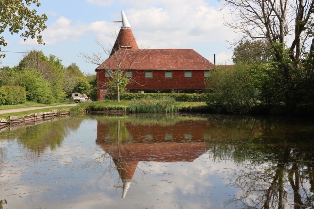
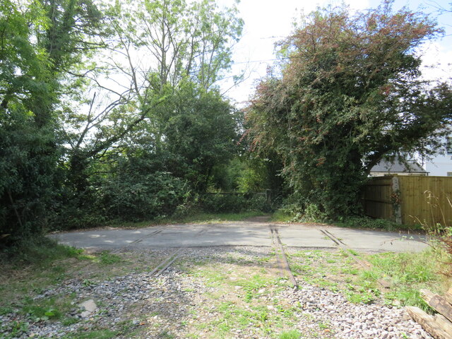
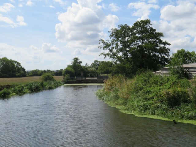
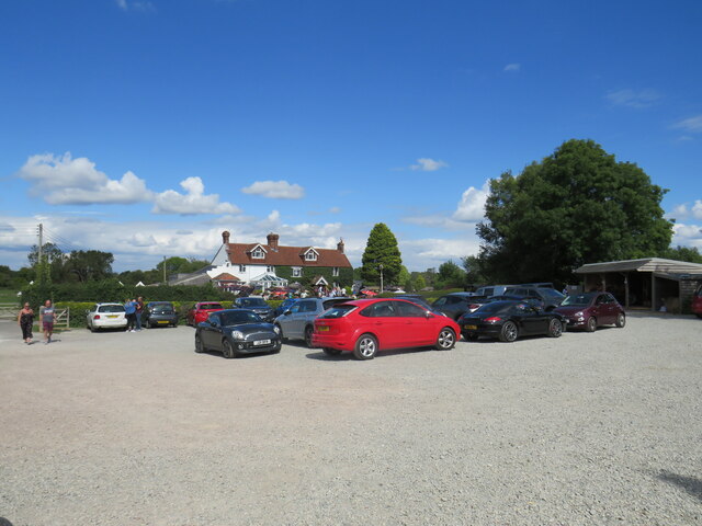
Mount Pleasant Images

Images are sourced within 2km of 50.933047/0.028262 or Grid Reference TQ4216. Thanks to Geograph Open Source API. All images are credited.

Oast House Single round kiln oast house.

Grade II listed.
Oast House
Single round kiln oast house. Grade II listed.
Spithurst, near Lewes Spithurst is a small hamlet in East Sussex countryside, between Uckfield and Lewes.

A telephone kiosk still stands, although the telephone has been removed.
Spithurst, near Lewes
Spithurst is a small hamlet in East Sussex countryside, between Uckfield and Lewes. A telephone kiosk still stands, although the telephone has been removed.
Boast Lane, Barcombe Cross, near Lewes Boast Lane is a minor road in East Sussex countryside, near the village of Barcombe Cross.  The blue sign indicates that it is a no-through road
Boast Lane, Barcombe Cross, near Lewes
Boast Lane is a minor road in East Sussex countryside, near the village of Barcombe Cross. The blue sign indicates that it is a no-through road
Spithurst Road, Barcombe Cross, near Lewes Spithurst Road is a minor road leading out of the village of Barcombe Cross in East Sussex.  The wooden signpost to the left of the road indicates the route of a public footpath
Spithurst Road, Barcombe Cross, near Lewes
Spithurst Road is a minor road leading out of the village of Barcombe Cross in East Sussex. The wooden signpost to the left of the road indicates the route of a public footpath
Dallas Lane, near Barcombe Cross Dallas Lane is a private road leading to a small number of houses in East Sussex countryside.  The road is a public right of way as a bridleway, indicated by the wooden signpost to the left of the image.
Dallas Lane, near Barcombe Cross
Dallas Lane is a private road leading to a small number of houses in East Sussex countryside. The road is a public right of way as a bridleway, indicated by the wooden signpost to the left of the image.
Anchor Lane, near Barcombe Cross Anchor Lane is a minor lane through East Sussex countryside.  Here it passes Delves Farm.
Anchor Lane, near Barcombe Cross
Anchor Lane is a minor lane through East Sussex countryside. Here it passes Delves Farm.
Former railway level crossing near Barcombe Cross A former railway route between Uckfield and Lewes in East Sussex.  Here, the former railway crosses Anchor Lane, a minor road.  The railway closed in 1969 but more than half a century later, rails were still in place where the line crossed the road.
Former railway level crossing near Barcombe Cross
A former railway route between Uckfield and Lewes in East Sussex. Here, the former railway crosses Anchor Lane, a minor road. The railway closed in 1969 but more than half a century later, rails were still in place where the line crossed the road.
Former railway level crossing near Barcombe Cross A view of Anchor Lane, near Barcombe Cross in East Sussex, at a former railway level crossing.  The line from Lewes to Uckfield crossed Anchor Lane here.  Although the line closed in 1969, rails are still in place more than half a century later at the site of the level crossing.
Former railway level crossing near Barcombe Cross
A view of Anchor Lane, near Barcombe Cross in East Sussex, at a former railway level crossing. The line from Lewes to Uckfield crossed Anchor Lane here. Although the line closed in 1969, rails are still in place more than half a century later at the site of the level crossing.
River Ouse near Barcombe Cross A view of the River Ouse in East Sussex, as it flows past the Anchor Inn.  The blue boats belong to a boat hire business which operates here.
River Ouse near Barcombe Cross
A view of the River Ouse in East Sussex, as it flows past the Anchor Inn. The blue boats belong to a boat hire business which operates here.
River Ouse near Barcombe Cross A view of the River Ouse as it flows through East Sussex countryside.
River Ouse near Barcombe Cross
A view of the River Ouse as it flows through East Sussex countryside.
Algae on the River Ouse, near Barcombe Cross Algae on the surface of the River Ouse in East Sussex.  The algae had built up over a very hot and dry spell during the summer of 2022.
Algae on the River Ouse, near Barcombe Cross
Algae on the surface of the River Ouse in East Sussex. The algae had built up over a very hot and dry spell during the summer of 2022.
Pub car park, near Barcombe Cross The car park of the Anchor Inn, alongside the River Ouse in East Sussex.
Pub car park, near Barcombe Cross
The car park of the Anchor Inn, alongside the River Ouse in East Sussex.
Anchor Inn, near Barcombe Cross The Anchor Inn, alongside the River Ouse in East Sussex.  This photograph was taken on a sunny Bank Holiday Monday in August 2022, when the pub was busy.
Anchor Inn, near Barcombe Cross
The Anchor Inn, alongside the River Ouse in East Sussex. This photograph was taken on a sunny Bank Holiday Monday in August 2022, when the pub was busy.
Former railway route near Barcombe Cross A former railway route, now used as a permissive bridleway, in East Sussex countryside near Barcombe Cross.  The railway, which closed in 1969, ran from Uckfield to Lewes.  Here there is a bridge where the former railway crosses a stream.
Former railway route near Barcombe Cross
A former railway route, now used as a permissive bridleway, in East Sussex countryside near Barcombe Cross. The railway, which closed in 1969, ran from Uckfield to Lewes. Here there is a bridge where the former railway crosses a stream.
Former railway route near Barcombe Cross A former railway route, now in use as a permissive bridleway, near Barcombe Cross in East Sussex.  The railway, which linked Uckfield with Lewes, closed in 1969.

Here, a footpath branches off to the right.
Former railway route near Barcombe Cross
A former railway route, now in use as a permissive bridleway, near Barcombe Cross in East Sussex. The railway, which linked Uckfield with Lewes, closed in 1969. Here, a footpath branches off to the right.
Former railway route near Barcombe Cross A permissive bridleway uses a section of former railway near Barcombe Cross in East Sussex.  The railway, which closed in 1969, linked the towns of Uckfield and Lewes.
Former railway route near Barcombe Cross
A permissive bridleway uses a section of former railway near Barcombe Cross in East Sussex. The railway, which closed in 1969, linked the towns of Uckfield and Lewes.
Former railway route near Barcombe Cross A former railway route, now used as a permissive bridleway, in East Sussex.  The railway linked the towns of Uckfield and Lewes.  It closed in 1969.

Here, the route crosses a stream.
Former railway route near Barcombe Cross
A former railway route, now used as a permissive bridleway, in East Sussex. The railway linked the towns of Uckfield and Lewes. It closed in 1969. Here, the route crosses a stream.
Former railway route near Barcombe Cross A former railway route, now used as a permissive bridleway, near Barcombe Cross in East Sussex.  The railway, which linked the towns of Uckfield and Lewes, closed in 1969.
Former railway route near Barcombe Cross
A former railway route, now used as a permissive bridleway, near Barcombe Cross in East Sussex. The railway, which linked the towns of Uckfield and Lewes, closed in 1969.
Show me another place!

Mount Pleasant is located at Grid Ref: TQ4216 (Lat: 50.933047, Lng: 0.028262)

Administrative County: East Sussex

District: Lewes

Police Authority: Sussex

What 3 Words

///gong.zone.buggy. Near South Chailey, East Sussex

Related Wikis

Barcombe

Barcombe is an East Sussex village and civil parish in the Lewes District of East Sussex. The parish has four settlements: old Barcombe (TQ 418 143), the...

Barcombe railway station

Barcombe was a railway station serving the village of Barcombe in East Sussex. It was part of the East Grinstead to Lewes line, part of which now makes...

Barcombe Mills

Barcombe Mills is a small settlement and an area of countryside including a local nature reserve near the village of Barcombe Cross in East Sussex, England...

Barcombe Mills railway station

Barcombe Mills is a disused railway station in the hamlet of Barcombe Mills, on the closed section of the Wealden Line. The station was opened in 1858...

River Uck

The River Uck is a river in East Sussex, United Kingdom, which drains a catchment starting near Crowborough in the North, Hadlow Down to the East and Laughton...

Isfield

Isfield is a small village and civil parish in the Wealden District of East Sussex in England, located north-east of Lewes. == History == The village of...

Lavender Line

The Lavender Line is a heritage railway based at Isfield Station, near Uckfield in East Sussex, England. == History == The Lavender Line was originally...

Isfield railway station

Isfield is a preserved railway station on the closed section of the Wealden Line which served the East Sussex village of Isfield near Uckfield. Originally...

Nearby Amenities

Located within 500m of 50.933047,0.028262
Post Box
Collection Times: Mo-Fr 09:00; Sa 07:00
Operator: Royal Mail
Operator Wikidata: Q638098
Post Box Mounting: wooden_pole
Post Box Type: lamp
Ref: BN8 489D
Royal Cypher: EIIR
Royal Cypher Wikidata: Q33102113
Lat/Long: 50.9305106/0.0309182
Telephone
Booth: K6
Covered: booth
Man Made: telephone_box
Lat/Long: 50.9327095/0.0252809
Post Box
Collection Times: Mo-Fr 09:00, Sa 07:00
Operator: Royal Mail
Operator Wikidata: Q638098
Post Box Mounting: brick_pillar
Post Box Type: wall
Ref: BN8 490D
Royal Cypher: GR
Royal Cypher Wikidata: Q33102273
Lat/Long: 50.9326483/0.0252642
Mount Pleasant
Place: hamlet
Lat/Long: 50.9341185/0.0263207
Oaktree Farm
Place: farm
Lat/Long: 50.9351737/0.0250143
Mount Pleasant Farm
Addr City: Barcombe
Addr Hamlet: Mount Pleasant
Addr Postcode: BN8 5EF
Addr Street: Spithurst Road
Place: farm
Lat/Long: 50.9323727/0.0243008
Burtenshaw Farm Airstrip
Addr City: Barcombe North
Aeroway: airstrip
Source: http://www.ukairfieldguide.net/airfields/Barcombe-North
Lat/Long: 50.9349121/0.0316211
Barrier: stile
Lat/Long: 50.9316934/0.0286837
Barrier: stile
Lat/Long: 50.9305359/0.030775
Barrier: stile
Lat/Long: 50.9342858/0.0301789
Power: pole
Lat/Long: 50.9316902/0.0220144
Power: pole
Lat/Long: 50.9324649/0.0223988
Power: pole
Lat/Long: 50.9330802/0.022966
Power: pole
Lat/Long: 50.9336566/0.0234922
Power: pole
Lat/Long: 50.9342343/0.0240472
Power: pole
Lat/Long: 50.9350543/0.0247892
Power: pole
Lat/Long: 50.9354675/0.0251756
The data included in this document is from www.openstreetmap.org. The data is made available under ODbL.

Have you been to Mount Pleasant?

Leave your review of Mount Pleasant below (or comments, questions and feedback).