West Wight

Heritage Site in Hampshire

England

West Wight

Entrance to Needles Old Battery A National Trust property in a former defensive battery on the western end of the Isle of Wight.
Entrance to Needles Old Battery Credit: Chris Allen

West Wight, Hampshire is a picturesque region located on the western coast of the Isle of Wight, an island off the southern coast of England. This area is renowned for its outstanding natural beauty, rich history, and diverse heritage sites.

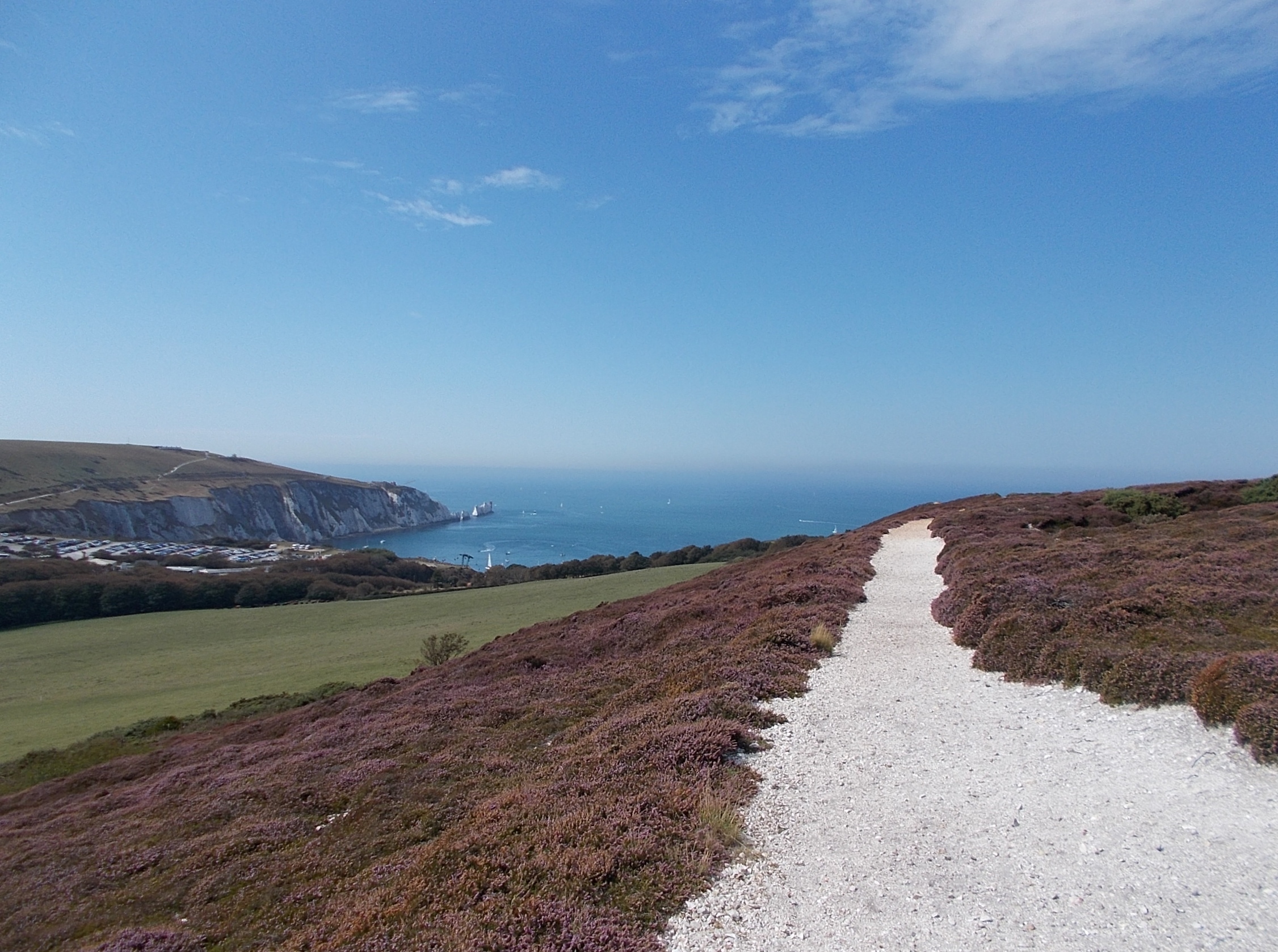
The landscape of West Wight is characterized by rolling hills, dramatic cliffs, and stunning coastal views. It is home to numerous charming villages and hamlets, such as Freshwater, Yarmouth, and Totland, which exude a traditional English countryside ambiance.

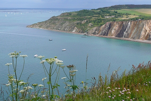
One of the most prominent heritage sites in West Wight is the Needles, a series of chalk stacks rising out of the sea. These iconic landmarks are a testament to the island's geological history and are a popular attraction for visitors. The Needles can be accessed via chairlift or enjoyed from the viewpoints along the coast.

Another significant historical site in West Wight is the Tennyson Down, named after the renowned poet Alfred Lord Tennyson, who resided in the area. This scenic chalk ridge offers breathtaking views of the surrounding landscape, including the coastline and the Needles.

The area also boasts several historic buildings and monuments, such as the Yarmouth Castle, a 16th-century fortification built by Henry VIII to defend against French invasions. Additionally, the Dimbola Lodge Museum in Freshwater showcases the life and works of pioneering Victorian photographer Julia Margaret Cameron.

Overall, West Wight, Hampshire is a captivating region that seamlessly blends natural beauty with a rich cultural heritage, offering visitors a unique experience and an opportunity to explore England's past.

If you have any feedback on the listing, please let us know in the comments section below.

West Wight Images

Images are sourced within 2km of 50.665/-1.563 or Grid Reference SZ3085. Thanks to Geograph Open Source API. All images are credited.

Entrance to Needles Old Battery A National Trust property in a former defensive battery on the western end of the Isle of Wight.
Entrance to Needles Old Battery
A National Trust property in a former defensive battery on the western end of the Isle of Wight.
Needles Old Battery - derelict generators This is in part of the National Trust owned defensive battery called 'the ditch'. This is out of bounds to the public and full of rusty equipment of various ages. This is probably WWII vintage and consists of a pair of internal combustion engine driven generators. They were in dreadful condition in 1990 and I doubt they will be any better now.
Needles Old Battery - derelict generators
This is in part of the National Trust owned defensive battery called 'the ditch'. This is out of bounds to the public and full of rusty equipment of various ages. This is probably WWII vintage and consists of a pair of internal combustion engine driven generators. They were in dreadful condition in 1990 and I doubt they will be any better now.
Needles Old Battery - derelict undertype steam engine The very sorry, incomplete remains of a Robey undertype semiportable engine. This is located in an area out of bounds to the public in the National Trust's Old Needles Battery.

In 1990 the remains of this Robey engine were 'preserved' in a plastic tent in the very damp archway where it has resided since c1890 and has been disused since c1900. The duplex cylinders are 7.5" x 12" and the flywheel is 7' 1" diameter. Two of us got in by prior arrangement and pleading a special interest - I am not sure that access would be allowed now as this part of the site is in poor condition.
Needles Old Battery - derelict undertype steam engine
The very sorry, incomplete remains of a Robey undertype semiportable engine. This is located in an area out of bounds to the public in the National Trust's Old Needles Battery. In 1990 the remains of this Robey engine were 'preserved' in a plastic tent in the very damp archway where it has resided since c1890 and has been disused since c1900. The duplex cylinders are 7.5" x 12" and the flywheel is 7' 1" diameter. Two of us got in by prior arrangement and pleading a special interest - I am not sure that access would be allowed now as this part of the site is in poor condition.
Needles Old Battery - derelict undertype steam engine In 1990 the remains of this Robey engine were 'preserved' in a plastic tent in the very damp archway where it has resided since c1890 and has been disused since c1900. The duplex cylinders are 7.5" x 12" and the flywheel is 7' 1" diameter. Two of us get in by prior arrangement and pleading a special interest - I am not sure that access would be allowed now as this part of the site is in poor condition.
Needles Old Battery - derelict undertype steam engine
In 1990 the remains of this Robey engine were 'preserved' in a plastic tent in the very damp archway where it has resided since c1890 and has been disused since c1900. The duplex cylinders are 7.5" x 12" and the flywheel is 7' 1" diameter. Two of us get in by prior arrangement and pleading a special interest - I am not sure that access would be allowed now as this part of the site is in poor condition.
Needles Old Battery - Campbell gas engine The National Trust very kindly agreed to allow me and a colleague into the moat area to view the remains of Robey undertype steam engines and this small gas engine by the Campbell Gas Engine Company of Halifax. This had apparently powered a lift and searchlights. As can be seen, it was in a protective plastic tent but in poor condition. I believe that this area is now in such a poor condition it is not regarded as safe to visit.
Needles Old Battery - Campbell gas engine
The National Trust very kindly agreed to allow me and a colleague into the moat area to view the remains of Robey undertype steam engines and this small gas engine by the Campbell Gas Engine Company of Halifax. This had apparently powered a lift and searchlights. As can be seen, it was in a protective plastic tent but in poor condition. I believe that this area is now in such a poor condition it is not regarded as safe to visit.
The Needles - Looking along the jagged rocks A view from the sea along the jagged chalk rocks of The Needles with most of <a href="https://www.geograph.org.uk/photo/7271521">SZ2884 : The Needles - The lighthouse</a> hidden behind the final one.
The Needles - Looking along the jagged rocks
A view from the sea along the jagged chalk rocks of The Needles with most of SZ2884 : The Needles - The lighthouse hidden behind the final one.
The Needles - Middle Stack This is a view of the middle of the three stacks that now make up The Needles off the western extremity of the Isle of Wight.
The Needles - Middle Stack
This is a view of the middle of the three stacks that now make up The Needles off the western extremity of the Isle of Wight.
The Needles - Inner stack This is the stack nearest the mainland of the Isle of Wight, indeed at low tide it may well be joined to the headland. Several cormorants (or shags) are dotted along its sharply pointed ridge.
The Needles - Inner stack
This is the stack nearest the mainland of the Isle of Wight, indeed at low tide it may well be joined to the headland. Several cormorants (or shags) are dotted along its sharply pointed ridge.
The Needles - View past innermost stack to Scratchell's Bay Looking through the gap between the innermost and middle stacks (the latter not visible) where once stood "Lot's Wife" - a column of chalk that collapsed in 1764.
Beyond lies Scratchell's Bay with <a href="https://www.geograph.org.uk/photo/7271728">SZ2984 : The Needles - Chalk cliffs east of Scratchell's Bay</a> behind.
The Needles - View past innermost stack to Scratchell's Bay
Looking through the gap between the innermost and middle stacks (the latter not visible) where once stood "Lot's Wife" - a column of chalk that collapsed in 1764. Beyond lies Scratchell's Bay with SZ2984 : The Needles - Chalk cliffs east of Scratchell's Bay behind.
The Needles - Chalk cliffs east of Scratchell's Bay The soaring chalk cliffs at the western extremity of the Isle of Wight mainland. The striations in the chalk can be well seen in this image and are at c. 45° compared to the near vertical strata in the Needles stacks. The bay between the camera and the cliffs is Scratchell's Bay.
The Needles - Chalk cliffs east of Scratchell's Bay
The soaring chalk cliffs at the western extremity of the Isle of Wight mainland. The striations in the chalk can be well seen in this image and are at c. 45° compared to the near vertical strata in the Needles stacks. The bay between the camera and the cliffs is Scratchell's Bay.
The Needles - Westernmost point of headland This is the westernmost extremity of the Isle of Wight's mainland headland just east of The Needles stacks. It has the unusual <a href="https://www.geograph.org.uk/photo/7271742">SZ2984 : The Needles - Pointing-finger chalk rock formation</a> and an upside-down V-shaped cave.
The Needles - Westernmost point of headland
This is the westernmost extremity of the Isle of Wight's mainland headland just east of The Needles stacks. It has the unusual SZ2984 : The Needles - Pointing-finger chalk rock formation and an upside-down V-shaped cave.
The Needles - Pointing-finger chalk rock formation In the saddle of the <a href="https://www.geograph.org.uk/photo/7271741">SZ2984 : The Needles - Westernmost point of headland</a> is this unusual rock formation which looks rather like a rude gesture with one's middle finger - or other people may think it resembles something else ...
A gull perches on the apex.
The Needles - Pointing-finger chalk rock formation
In the saddle of the SZ2984 : The Needles - Westernmost point of headland is this unusual rock formation which looks rather like a rude gesture with one's middle finger - or other people may think it resembles something else ... A gull perches on the apex.
The Needles - New Battery - Look-out station A view of the WWII look-out station which forms part of the New Battery at The Needles. 
The site is a Scheduled Monument <span class="nowrap"><a title="https://historicengland.org.uk/listing/the-list/list-entry/1009392?section=official-list-entry" rel="nofollow ugc noopener" href="https://historicengland.org.uk/listing/the-list/list-entry/1009392?section=official-list-entry">Link</a><img style="margin-left:2px;" alt="External link" title="External link - shift click to open in new window" src="https://s1.geograph.org.uk/img/external.png" width="10" height="10"/></span>
It is administered by the National Trust <span class="nowrap"><a title="https://www.nationaltrust.org.uk/the-needles-old-battery-and-new-battery" rel="nofollow ugc noopener" href="https://www.nationaltrust.org.uk/the-needles-old-battery-and-new-battery">Link</a><img style="margin-left:2px;" alt="External link" title="External link - shift click to open in new window" src="https://s1.geograph.org.uk/img/external.png" width="10" height="10"/></span>
The Needles - New Battery - Look-out station
A view of the WWII look-out station which forms part of the New Battery at The Needles. The site is a Scheduled Monument LinkExternal link It is administered by the National Trust LinkExternal link
The Needles - Former look-out windows in the cliff Tunnels were dug down through the chalk cliffs from the battery a few hundred feet above these 'windows' which were created as look-out casements to observe ships and boats entering the western Solent.
See closer views:
<a href="https://www.geograph.org.uk/photo/7272037">SZ2984 : The Needles - Former look-out windows in the cliff - zoomed</a>
<a href="https://www.geograph.org.uk/photo/7272040">SZ2984 : The Needles - One of the former look-out casements</a>
The Needles - Former look-out windows in the cliff
Tunnels were dug down through the chalk cliffs from the battery a few hundred feet above these 'windows' which were created as look-out casements to observe ships and boats entering the western Solent. See closer views: SZ2984 : The Needles - Former look-out windows in the cliff - zoomed SZ2984 : The Needles - One of the former look-out casements
The Needles - Former look-out windows in the cliff - zoomed A zoomed view of <a href="https://www.geograph.org.uk/photo/7272032">SZ2984 : The Needles - Former look-out windows in the cliff</a> with three of the 'windows' in this view - the westernmost having been filled in with rocks.
For a closer view of the middle casement, see <a href="https://www.geograph.org.uk/photo/7272040">SZ2984 : The Needles - One of the former look-out casements</a>
The Needles - Former look-out windows in the cliff - zoomed
A zoomed view of SZ2984 : The Needles - Former look-out windows in the cliff with three of the 'windows' in this view - the westernmost having been filled in with rocks. For a closer view of the middle casement, see SZ2984 : The Needles - One of the former look-out casements
The Needles - One of the former look-out casements A zoomed view of the central former look-out casement in <a href="https://www.geograph.org.uk/photo/7272037">SZ2984 : The Needles - Former look-out windows in the cliff - zoomed</a>
See also <a href="https://www.geograph.org.uk/photo/7272032">SZ2984 : The Needles - Former look-out windows in the cliff</a>
The Needles - One of the former look-out casements
The Needles, Isle of Wight
The Needles, Isle of Wight The lighthouse is in the next square west, and so I have given the subject as the needle just east of it!
The Needles, Isle of Wight
The lighthouse is in the next square west, and so I have given the subject as the needle just east of it!
Show me another place!

West Wight is located at Grid Ref: SZ3085 (Lat: 50.665, Lng: -1.563)

Unitary Authority: Isle of Wight

Police Authority: Hampshire

What 3 Words

///airliners.directive.pepper. Near Totland, Isle of Wight

Related Wikis

Headon Warren and West High Down SSSI

Headon Warren and West High Down is a 276.3-hectare (683-acre) Site of Special Scientific Interest (SSSI) located at the westernmost end of the Isle of...

Hatherwood Battery

Hatherwood Battery (map reference SZ308857) is a battery located to the east of Alum Bay on the Isle of Wight. It is one of the many Palmerston Forts built...

Alum Bay

Alum Bay is a bay near the westernmost point of the Isle of Wight, England, within close sight of the Needles rock formation. Of geological interest and...

High Down Rocket Test Site

The High Down Rocket Test Site is a former Rocket Testing facility on High Down near The Needles. The remains of the High Down Test Site are a rare example...

Nearby Amenities

Located within 500m of 50.665,-1.563
Alum Bay
Is In: Hampshire, England, UK
Place: hamlet
Wikidata: Q447363
Wikipedia: en:Alum Bay
Lat/Long: 50.6678791/-1.5657608
Source: Bing
Lat/Long: 50.663181/-1.5597368
Source: Bing
Lat/Long: 50.6630896/-1.5603136
Source: Bing
Lat/Long: 50.6630057/-1.5616118
Source: Bing
Lat/Long: 50.662945/-1.5620137
Source: Bing
Lat/Long: 50.6628547/-1.5628322
Source: PGS
Lat/Long: 50.662659/-1.5637557
Source: Bing
Lat/Long: 50.661898/-1.5657523
Source: Bing
Lat/Long: 50.6617365/-1.5667352
Source: Bing
Lat/Long: 50.6616661/-1.566866
Source: Bing
Lat/Long: 50.6615211/-1.5672257
Source: Bing
Lat/Long: 50.6622917/-1.5681574
Source: Bing
Lat/Long: 50.6630851/-1.5650605
Toilets
Fee: no
Lat/Long: 50.6678122/-1.5654145
Bus Stop
Needles Landmark Attraction
Bench: no
Bus: yes
Contact Website: https://www.islandbuses.info/stops/230000106
Naptan AtcoCode: 230000106
Naptan NaptanCode: iowmpmp
Public Transport: platform
Shelter: no
Lat/Long: 50.6680002/-1.565456
WD S2
Ele: 462ft
Man Made: survey_point
Source: OS 1:25k
Lat/Long: 50.6635002/-1.5673331
Toilets
Access: customers
Operator: Warren Farm
Lat/Long: 50.6672891/-1.5590821
Aerialway: station
Public Transport: station
Lat/Long: 50.6684387/-1.5664841
Bus Stop
Needles Landmark Attraction
Bench: no
Bus: yes
Contact Website: https://www.islandbuses.info/stops/230000013190
Naptan AtcoCode: 230000013190
Naptan NaptanCode: iowjwgm
Public Transport: platform
Shelter: no
Survey Date: 2019-03-05
Lat/Long: 50.6679384/-1.5657679
Bus Stop
Needles Landmark Attraction
Bus: yes
Contact Website: https://www.islandbuses.info/stops/230000013200
Naptan AtcoCode: 230000013200
Naptan NaptanCode: iowjwgp
Public Transport: platform
Shelter: no
Survey Date: 2019-03-05
Lat/Long: 50.6680188/-1.5656115
Bus Stop
Top Car Park
Bus: yes
Contact Website: https://www.islandbuses.info/stops/230000013220
Naptan AtcoCode: 230000013220
Naptan Bearing: S
Naptan CommonName: Car Park
Naptan Indicator: opp
Naptan NaptanCode: iowjwgw
Naptan Street: Road to Battery
Public Transport: platform
Shelter: no
Lat/Long: 50.6665193/-1.5657788
Bus Stop
Car Park
Bus: yes
Naptan AtcoCode: 2300209
Naptan Bearing: N
Naptan BusStopType: CUS
Naptan CommonName: Car Park
Naptan Indicator: adj
Naptan NaptanCode: iowmgdt
Naptan Street: Road to Battery
Naptan Verified: no
Public Transport: platform
Shelter: no
Lat/Long: 50.6665274/-1.565991
Jurassic Golf
Leisure: miniature_golf
Lat/Long: 50.6683829/-1.5672499
Cafe
The Needles Perk
Addr City: Totland
Addr Country: GB
Addr Postcode: PO39 0JD
Addr Street: Alum Bay New Road
Fhrs Id: 540753
Outdoor Seating: yes
Source Addr: FHRS Open Data
Lat/Long: 50.6684221/-1.566673
Restaurant
The Pantry
Lat/Long: 50.6676878/-1.5660415
Pub
Marconi's
Outdoor Seating: yes
Lat/Long: 50.6678388/-1.5662415
Sand Shop
Check Date: 2023-07-25
Shop: gift
Website: https://www.theneedles.co.uk/shop/sand-shop/
Lat/Long: 50.6682143/-1.5663178
Post Box
Collection Plate: CP7
Collection Times: Mo-Fr 16:15; Sa 10:30
Operator: Royal Mail
Operator Wikidata: Q638098
Post Box Type: lamp
Ref: PO39 43
Ref GB Uprn: 10015399524
Royal Cypher: EIIR
Royal Cypher Wikidata: Q33102113
Website: https://www.royalmail.com/services-near-you/postbox/alum-bay-po39-0jh/0000PO3943
Lat/Long: 50.6677152/-1.5656589
Toilets
Lat/Long: 50.6682343/-1.5669703
Source: Bing
Lat/Long: 50.6637878/-1.5616193
Source: Bing
Lat/Long: 50.6631974/-1.5587543
Source: Bing
Lat/Long: 50.6631267/-1.5591286
Barrier: kissing_gate
Lat/Long: 50.6689119/-1.5646817
Crossing
Crossing: uncontrolled
Crossing Island: no
Crossing Ref: zebra
Kerb: lowered
Lat/Long: 50.6673472/-1.5656614
Bicycle Parking
Bicycle Parking: stands
Capacity: 4
Covered: no
Lat/Long: 50.6666407/-1.5657316
Bench
Backrest: no
Mapillary: 295677282011344
Survey Date: 2019-01-14
Lat/Long: 50.6649644/-1.5694391
Information: guidepost
Tourism: information
Lat/Long: 50.6687883/-1.5647094
Crossing
Crossing: uncontrolled
Crossing Ref: zebra
Kerb: lowered
Lat/Long: 50.6677403/-1.5655666
Cafe
Warren Farm Tea Rooms
Addr City: Alum Bay
Addr Country: GB
Addr County: Isle of Wight
Addr Housename: Warren Farm
Addr Postcode: PO39 0JB
Addr Street: Alum Bay New Road
Contact Website: https://www.warrenfarmiow.co.uk/farm-shop-tea-gardens
Fhrs Id: 540755
Opening Hours: Sa-Th 12:00-17:30
Shop: farm
Lat/Long: 50.6673415/-1.5587021
Hiking: yes
Information: guidepost
Tourism: information
Lat/Long: 50.6684874/-1.5632075
Telephone
Booth: KX100
Covered: booth
Mapillary: 515277303164182
Operator: BT
Operator Wikidata: Q593786
Ref GB Uprn: 10024891322
Survey Date: 2019-08-19
Lat/Long: 50.6681108/-1.5650006
Hiking: yes
Information: guidepost
Tourism: information
Lat/Long: 50.668053/-1.5653318
Hiking: yes
Information: guidepost
Tourism: information
Lat/Long: 50.666004/-1.565702
Turning Circle
Lat/Long: 50.6663042/-1.5652444
Leisure: picnic_table
Lat/Long: 50.6683403/-1.566681
Leisure: picnic_table
Lat/Long: 50.6683514/-1.56674
Leisure: picnic_table
Lat/Long: 50.6683633/-1.5667923
Leisure: picnic_table
Lat/Long: 50.6683786/-1.5668473
Entrance: main
Lat/Long: 50.6673366/-1.5655028
Barrier: kerb
Lat/Long: 50.6677555/-1.5656435
Entrance: yes
Lat/Long: 50.6677659/-1.565455
Entrance: yes
Lat/Long: 50.6678605/-1.5653675
Traffic Calming: hump
Lat/Long: 50.6678832/-1.565502
Leisure: picnic_table
Lat/Long: 50.6678456/-1.5660406
Leisure: picnic_table
Lat/Long: 50.6679697/-1.5659333
Leisure: picnic_table
Lat/Long: 50.6678175/-1.566109
Leisure: picnic_table
Lat/Long: 50.6678719/-1.566111
Alum Bay Glass Shop
Shop: interior_decoration
Website: https://www.theneedles.co.uk/shop/alum-bay-glass/
Lat/Long: 50.667509/-1.5654619
Admin Office
Office: administrative
Lat/Long: 50.6676764/-1.5653694
Historic: memorial
Inscription: This stone marks the site of the Needles telegraph station where Guglielmo Marconi and his British collaborators carries out from 6th December 1897 to 26th May 1900 a series of experiments which constituted some of the more important phases of their...
Memorial: plaque
Openplaques Id: 1648
Lat/Long: 50.6681088/-1.5679543
Bicycle Parking
Lat/Long: 50.6672735/-1.5659031
Bus Stop
Needles Landmark Attraction
Bus: yes
Contact Website: https://www.islandbuses.info/stops/230000108
Naptan AtcoCode: 230000108
Naptan NaptanCode: iowmpmt
Public Transport: platform
Survey Date: 2019-03-05
Lat/Long: 50.6678481/-1.5656697
Barrier: kerb
Lat/Long: 50.6677354/-1.5655417
Barrier: kerb
Lat/Long: 50.6673436/-1.5656158
Barrier: kerb
Lat/Long: 50.6673519/-1.5657196
Operator: Warren Farm
Playground: structure
Lat/Long: 50.6671001/-1.5591574
Bar
The Wight Horsebox Bar
Contact Website: https://www.warrenfarmiow.co.uk/the-wight-horsebox-bar
Outdoor Seating: only
Lat/Long: 50.6672693/-1.5587617
Access: customers
Leisure: outdoor_seating
Operator: Warren Farm
Lat/Long: 50.667322/-1.5585633
Ice Cream
Beatrice's
Lat/Long: 50.668135/-1.5658408
Ice Cream
Victoria's
Lat/Long: 50.6680963/-1.5657596
Fast Food
Albert's
Lat/Long: 50.6681575/-1.565942
Island Gold & Silver
Shop: jewelry
Lat/Long: 50.6679399/-1.5662585
Pier Head
Shop: gift
Website: https://www.theneedles.co.uk/shop/pier-head/
Lat/Long: 50.6680147/-1.5662612
4D Cinema
Attraction: yes
Website: https://www.theneedles.co.uk/attractions/4d-cinema/
Lat/Long: 50.6681525/-1.5661123
Barrier: stile
Lat/Long: 50.6621526/-1.5682051
Parking Space
Bus: yes
Motor Vehicle: no
Parking: surface
Lat/Long: 50.6671682/-1.5655109
Parking Space
Bus: yes
Motor Vehicle: no
Parking: surface
Lat/Long: 50.6671163/-1.5655168
Parking Space
Bus: yes
Motor Vehicle: no
Parking: surface
Lat/Long: 50.6670722/-1.5655219
Parking Space
Bus: yes
Motor Vehicle: no
Parking: surface
Lat/Long: 50.6670337/-1.5655263
Parking Space
Bus: yes
Motor Vehicle: no
Parking: surface
Lat/Long: 50.6669873/-1.5655317
Parking Space
Bus: yes
Motor Vehicle: no
Parking: surface
Lat/Long: 50.6669412/-1.565537
Parking Space
Bus: yes
Motor Vehicle: no
Parking: surface
Lat/Long: 50.6668937/-1.5655424
Parking Space
Bus: yes
Motor Vehicle: no
Parking: surface
Lat/Long: 50.6668537/-1.565547
Parking Space
Bus: yes
Motor Vehicle: no
Parking: surface
Lat/Long: 50.6668009/-1.5655531
Parking Space
Bus: yes
Motor Vehicle: no
Parking: surface
Lat/Long: 50.6672089/-1.5655062
The data included in this document is from www.openstreetmap.org. The data is made available under ODbL.

Have you been to West Wight?

Leave your review of West Wight below (or comments, questions and feedback).