Alum Bay Chine

Valley in Hampshire

England

Alum Bay Chine

The Old Battery
The Old Battery Credit: Barry Shimmon

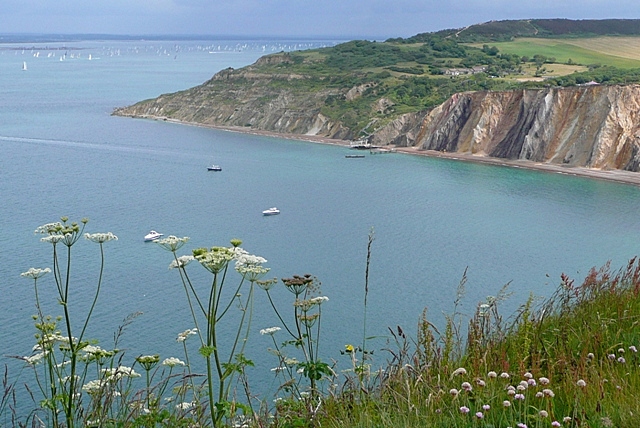
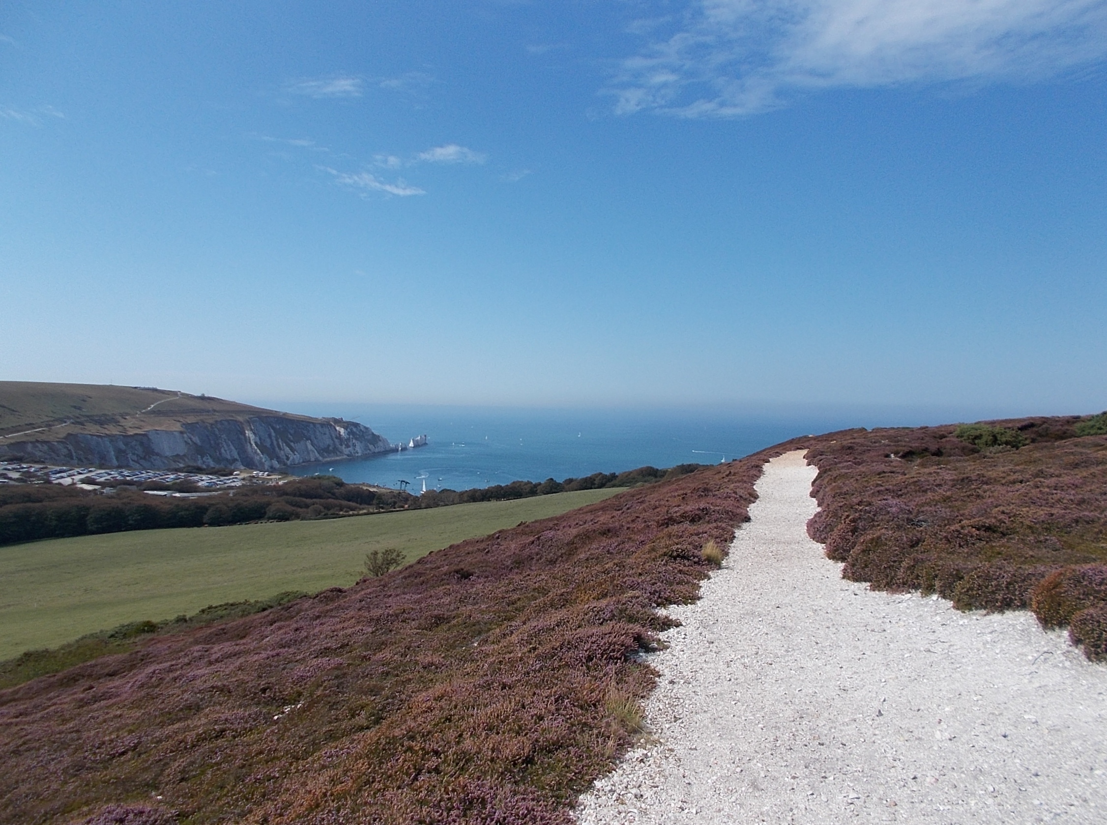
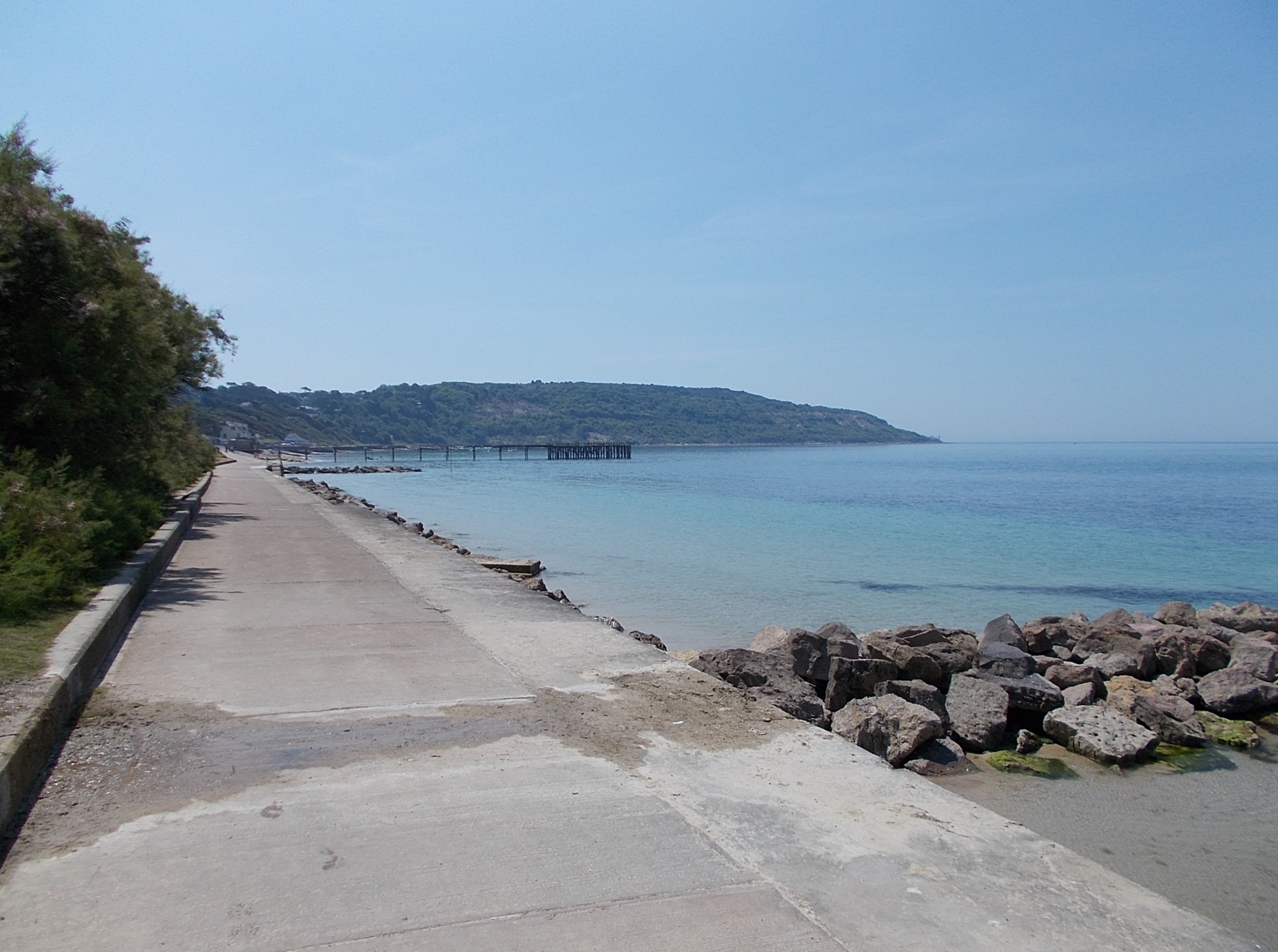
Alum Bay Chine is a picturesque valley located on the western side of the Isle of Wight in Hampshire, England. It is famous for its stunning geological features and breathtaking coastal scenery. The chine, which is a local term for a steep-sided ravine, has been formed over thousands of years by erosion from the sea and is a popular tourist destination.

One of the most distinctive features of Alum Bay Chine is its multi-colored sand cliffs, which are composed of layers of different minerals. These cliffs display a vibrant array of hues, ranging from deep reds and oranges to bright greens and purples. Visitors can explore the chine by taking a scenic walk down a zigzag path that leads them through the lush vegetation and offers glimpses of the stunning cliffs.

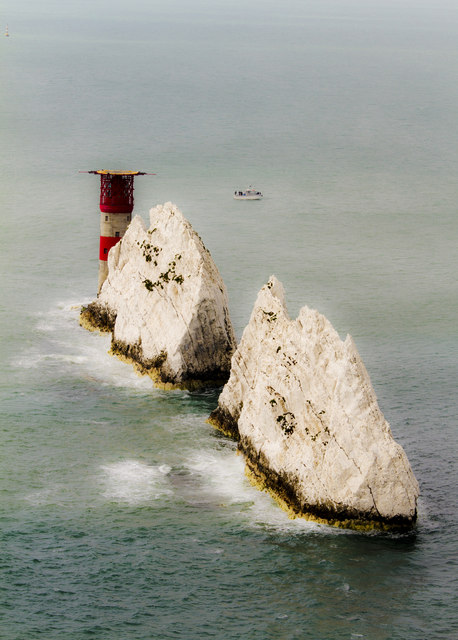
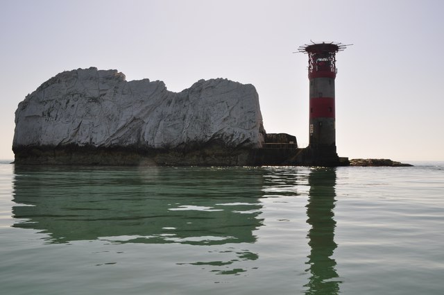
At the bottom of the chine, visitors are greeted by a beautiful beach, known for its pristine white sand. The beach is a popular spot for sunbathing, picnicking, and taking part in various water activities, such as swimming and kayaking. Additionally, Alum Bay Chine is famous for its unique rock formations, including the iconic "Needles" – a series of chalk stacks rising from the sea.

In addition to its natural beauty, Alum Bay Chine offers a range of attractions for visitors. These include a chairlift that provides panoramic views of the surrounding area, a children's play area, and a souvenir shop where visitors can purchase unique sand souvenirs crafted from the chine's colorful sands.

Overall, Alum Bay Chine is a must-visit destination for nature lovers and those seeking a scenic getaway. Its stunning cliffs, beautiful beach, and unique geological features make it a truly remarkable place to explore and appreciate the wonders of nature.

If you have any feedback on the listing, please let us know in the comments section below.

Alum Bay Chine Images

Images are sourced within 2km of 50.668841/-1.5672453 or Grid Reference SZ3085. Thanks to Geograph Open Source API. All images are credited.

The Old Battery
The Old Battery
Isle of Wight from Mudeford Spit The grass dunes on Mudeford spit frame the tip of the Isle of Wight, including The Needles. A couple of holidaymakers are just visible bottom left.
Isle of Wight from Mudeford Spit
The grass dunes on Mudeford spit frame the tip of the Isle of Wight, including The Needles. A couple of holidaymakers are just visible bottom left.
The Guns One of the two guns at The Old Battery by The Needles
The Guns
One of the two guns at The Old Battery by The Needles
The Needles Viewed from the Old Battery
The Needles
Viewed from the Old Battery
The Needles Isle of Wight
The Needles from the Old Battery
Alum Bay in 1988 As seen from the Old Battery. Hatherwood Point is on the right of the frame.
Alum Bay in 1988
As seen from the Old Battery. Hatherwood Point is on the right of the frame.
The Needles 1984
The Needles 1984
The Needles and the Old Battery A view of the Needles from the coastal path.
The Needles and the Old Battery
A view of the Needles from the coastal path.
South Wight : The Solent Looking towards the gap between Hampshire and the Isle of Wight which leads into the Solent.
South Wight : The Solent
Looking towards the gap between Hampshire and the Isle of Wight which leads into the Solent.
South Wight : Beacon & Bournemouth Looking towards a red beacon in the sea with the Bournemouth coastline behind it.
South Wight : Beacon & Bournemouth
Looking towards a red beacon in the sea with the Bournemouth coastline behind it.
South Wight : The Needles & Lighthouse The Needles were featured on the 2005 TV programme Seven Natural Wonders as one of the wonders of Southern England.
South Wight : The Needles & Lighthouse
The Needles were featured on the 2005 TV programme Seven Natural Wonders as one of the wonders of Southern England.
South Wight : The Needles & Cliffs Looking towards the cliffs from a boat travelling along the Needles.
South Wight : The Needles & Cliffs
Looking towards the cliffs from a boat travelling along the Needles.
South Wight : The Needles & Former Pillar The formation takes its name from the former fourth needle-shaped pillar called Lot's Wife that used to stand in its midst until it collapsed in a storm in 1764. The remaining rocks are all short and squat and not at all needle-like, but the name has stuck.
South Wight : The Needles & Former Pillar
The formation takes its name from the former fourth needle-shaped pillar called Lot's Wife that used to stand in its midst until it collapsed in a storm in 1764. The remaining rocks are all short and squat and not at all needle-like, but the name has stuck.
South Wight : Needles Lighthouse 1859 by James Walker, consultant engineer to Trinity House, replacing an earlier lighthouse which stood on the cliff top. Built of granite masonry. 33.25 metres high of uniform diameter with an unevenly stepped base. Although the tower has no taper the walls vary from 1.07 metres in thickness at the bottom to 0.61 metres at the top. Battlemented parapet.
South Wight : Needles Lighthouse
1859 by James Walker, consultant engineer to Trinity House, replacing an earlier lighthouse which stood on the cliff top. Built of granite masonry. 33.25 metres high of uniform diameter with an unevenly stepped base. Although the tower has no taper the walls vary from 1.07 metres in thickness at the bottom to 0.61 metres at the top. Battlemented parapet.
South Wight : The Needles & Cormorant A cormorant on the top of one of the Needles rocks beside a shag.
South Wight : The Needles & Cormorant
A cormorant on the top of one of the Needles rocks beside a shag.
South Wight : The Needles Looking towards the edge of the Needles with the lighthouse at the point.
South Wight : The Needles
Looking towards the edge of the Needles with the lighthouse at the point.
South Wight : The Needles One of the rocks that head out to sea to form the Needles.
South Wight : The Needles
One of the rocks that head out to sea to form the Needles.
Show me another place!

Alum Bay Chine is located at Grid Ref: SZ3085 (Lat: 50.668841, Lng: -1.5672453)

Unitary Authority: Isle of Wight

Police Authority: Hampshire

What 3 Words

///dampen.custard.magically. Near Totland, Isle of Wight

Related Wikis

Hatherwood Battery

Hatherwood Battery (map reference SZ308857) is a battery located to the east of Alum Bay on the Isle of Wight. It is one of the many Palmerston Forts built...

Headon Warren and West High Down SSSI

Headon Warren and West High Down is a 276.3-hectare (683-acre) Site of Special Scientific Interest (SSSI) located at the westernmost end of the Isle of...

Alum Bay

Alum Bay is a bay near the westernmost point of the Isle of Wight, England, within close sight of the Needles rock formation. Of geological interest and...

High Down Rocket Test Site

The High Down Rocket Test Site is a former Rocket Testing facility on High Down near The Needles. The remains of the High Down Test Site are a rare example...

The Needles Batteries

The Needles Batteries are two military batteries built above the Needles stacks to guard the West end of the Solent. The field of fire was from approximately...

Scratchell's Bay

Scratchell's Bay is a bay on the south west coast of the Isle of Wight, England just to the south east of The Needles. It faces roughly south towards the...

HMS Assurance (1747)

HMS Assurance was a 44-gun fifth rate frigate of the Royal Navy, launched in 1747. She was wrecked off The Needles near the Isle of Wight, England in 1753...

Totland Bay

Totland Bay is a bay on the west coast of the Isle of Wight, England. It lies one-quarter of an mile (0.4 km) to the west of the village of Totland from...

Nearby Amenities

Located within 500m of 50.668841,-1.5672453
Alum Bay
Is In: Hampshire, England, UK
Place: hamlet
Wikidata: Q447363
Wikipedia: en:Alum Bay
Lat/Long: 50.6678791/-1.5657608
Toilets
Fee: no
Lat/Long: 50.6678122/-1.5654145
Bus Stop
Needles Landmark Attraction
Bench: no
Bus: yes
Contact Website: https://www.islandbuses.info/stops/230000106
Naptan AtcoCode: 230000106
Naptan NaptanCode: iowmpmp
Public Transport: platform
Shelter: no
Lat/Long: 50.6680002/-1.565456
Aerialway: station
Public Transport: station
Lat/Long: 50.6691253/-1.5695628
Aerialway: station
Public Transport: station
Lat/Long: 50.6684387/-1.5664841
Hatherwood Point.
Place: locality
Source: NPE
Lat/Long: 50.6726682/-1.5704823
Bus Stop
Needles Landmark Attraction
Bench: no
Bus: yes
Contact Website: https://www.islandbuses.info/stops/230000013190
Naptan AtcoCode: 230000013190
Naptan NaptanCode: iowjwgm
Public Transport: platform
Shelter: no
Survey Date: 2019-03-05
Lat/Long: 50.6679384/-1.5657679
Bus Stop
Needles Landmark Attraction
Bus: yes
Contact Website: https://www.islandbuses.info/stops/230000013200
Naptan AtcoCode: 230000013200
Naptan NaptanCode: iowjwgp
Public Transport: platform
Shelter: no
Survey Date: 2019-03-05
Lat/Long: 50.6680188/-1.5656115
Bus Stop
Top Car Park
Bus: yes
Contact Website: https://www.islandbuses.info/stops/230000013220
Naptan AtcoCode: 230000013220
Naptan Bearing: S
Naptan CommonName: Car Park
Naptan Indicator: opp
Naptan NaptanCode: iowjwgw
Naptan Street: Road to Battery
Public Transport: platform
Shelter: no
Lat/Long: 50.6665193/-1.5657788
Bus Stop
Car Park
Bus: yes
Naptan AtcoCode: 2300209
Naptan Bearing: N
Naptan BusStopType: CUS
Naptan CommonName: Car Park
Naptan Indicator: adj
Naptan NaptanCode: iowmgdt
Naptan Street: Road to Battery
Naptan Verified: no
Public Transport: platform
Shelter: no
Lat/Long: 50.6665274/-1.565991
Jurassic Golf
Leisure: miniature_golf
Lat/Long: 50.6683829/-1.5672499
Cafe
The Needles Perk
Addr City: Totland
Addr Country: GB
Addr Postcode: PO39 0JD
Addr Street: Alum Bay New Road
Fhrs Id: 540753
Outdoor Seating: yes
Source Addr: FHRS Open Data
Lat/Long: 50.6684221/-1.566673
Restaurant
The Pantry
Lat/Long: 50.6676878/-1.5660415
Pub
Marconi's
Outdoor Seating: yes
Lat/Long: 50.6678388/-1.5662415
Sand Shop
Check Date: 2023-07-25
Shop: gift
Website: https://www.theneedles.co.uk/shop/sand-shop/
Lat/Long: 50.6682143/-1.5663178
Post Box
Collection Plate: CP7
Collection Times: Mo-Fr 16:15; Sa 10:30
Operator: Royal Mail
Operator Wikidata: Q638098
Post Box Type: lamp
Ref: PO39 43
Ref GB Uprn: 10015399524
Royal Cypher: EIIR
Royal Cypher Wikidata: Q33102113
Website: https://www.royalmail.com/services-near-you/postbox/alum-bay-po39-0jh/0000PO3943
Lat/Long: 50.6677152/-1.5656589
Toilets
Lat/Long: 50.6682343/-1.5669703
Barrier: kissing_gate
Lat/Long: 50.6689119/-1.5646817
Crossing
Crossing: uncontrolled
Crossing Island: no
Crossing Ref: zebra
Kerb: lowered
Lat/Long: 50.6673472/-1.5656614
Bicycle Parking
Bicycle Parking: stands
Capacity: 4
Covered: no
Lat/Long: 50.6666407/-1.5657316
Bench
Backrest: no
Mapillary: 295677282011344
Survey Date: 2019-01-14
Lat/Long: 50.6649644/-1.5694391
Information: guidepost
Tourism: information
Lat/Long: 50.6687883/-1.5647094
Information: guidepost
Tourism: information
Lat/Long: 50.6689312/-1.5672812
Hatherwood Battery
Historic: ruins
Wikidata: Q5681507
Wikipedia: en:Hatherwood Battery
Lat/Long: 50.6710527/-1.5667253
Crossing
Crossing: uncontrolled
Crossing Ref: zebra
Kerb: lowered
Lat/Long: 50.6677403/-1.5655666
Information: board
Tourism: information
Lat/Long: 50.6708044/-1.5657073
Hiking: yes
Information: guidepost
Tourism: information
Lat/Long: 50.6709659/-1.5656564
Hiking: yes
Information: guidepost
Tourism: information
Lat/Long: 50.6684874/-1.5632075
Telephone
Booth: KX100
Covered: booth
Mapillary: 515277303164182
Operator: BT
Operator Wikidata: Q593786
Ref GB Uprn: 10024891322
Survey Date: 2019-08-19
Lat/Long: 50.6681108/-1.5650006
Hiking: yes
Information: guidepost
Tourism: information
Lat/Long: 50.668053/-1.5653318
Hiking: yes
Information: guidepost
Tourism: information
Lat/Long: 50.666004/-1.565702
Bench
Lat/Long: 50.6716917/-1.5623921
Hiking: yes
Information: guidepost
Tourism: information
Lat/Long: 50.6717903/-1.5624645
Turning Circle
Lat/Long: 50.6663042/-1.5652444
Leisure: picnic_table
Lat/Long: 50.6683403/-1.566681
Leisure: picnic_table
Lat/Long: 50.6683514/-1.56674
Leisure: picnic_table
Lat/Long: 50.6683633/-1.5667923
Leisure: picnic_table
Lat/Long: 50.6683786/-1.5668473
Entrance: main
Lat/Long: 50.6673366/-1.5655028
Barrier: kerb
Lat/Long: 50.6677555/-1.5656435
Entrance: yes
Lat/Long: 50.6677659/-1.565455
Entrance: yes
Lat/Long: 50.6678605/-1.5653675
Traffic Calming: hump
Lat/Long: 50.6678832/-1.565502
Leisure: picnic_table
Lat/Long: 50.6678456/-1.5660406
Leisure: picnic_table
Lat/Long: 50.6679697/-1.5659333
Leisure: picnic_table
Lat/Long: 50.6678175/-1.566109
Leisure: picnic_table
Lat/Long: 50.6678719/-1.566111
Alum Bay Glass Shop
Shop: interior_decoration
Website: https://www.theneedles.co.uk/shop/alum-bay-glass/
Lat/Long: 50.667509/-1.5654619
Admin Office
Office: administrative
Lat/Long: 50.6676764/-1.5653694
Tourism: viewpoint
Lat/Long: 50.6681142/-1.5682742
Historic: memorial
Inscription: This stone marks the site of the Needles telegraph station where Guglielmo Marconi and his British collaborators carries out from 6th December 1897 to 26th May 1900 a series of experiments which constituted some of the more important phases of their...
Memorial: plaque
Openplaques Id: 1648
Lat/Long: 50.6681088/-1.5679543
Bicycle Parking
Lat/Long: 50.6672735/-1.5659031
Waste Basket
Waste: trash
Lat/Long: 50.6681065/-1.5682273
Seamark Rock Water Level: awash
Seamark Type: rock
Lat/Long: 50.6668349/-1.571635
Seamark Rock Water Level: awash
Seamark Type: rock
Lat/Long: 50.6669301/-1.5716189
Seamark Rock Water Level: awash
Seamark Type: rock
Lat/Long: 50.6665663/-1.5702081
Bus Stop
Needles Landmark Attraction
Bus: yes
Contact Website: https://www.islandbuses.info/stops/230000108
Naptan AtcoCode: 230000108
Naptan NaptanCode: iowmpmt
Public Transport: platform
Survey Date: 2019-03-05
Lat/Long: 50.6678481/-1.5656697
Barrier: kerb
Lat/Long: 50.6677354/-1.5655417
Barrier: kerb
Lat/Long: 50.6673436/-1.5656158
Barrier: kerb
Lat/Long: 50.6673519/-1.5657196
Ice Cream
Beatrice's
Lat/Long: 50.668135/-1.5658408
Ice Cream
Victoria's
Lat/Long: 50.6680963/-1.5657596
Fast Food
Albert's
Lat/Long: 50.6681575/-1.565942
Island Gold & Silver
Shop: jewelry
Lat/Long: 50.6679399/-1.5662585
Pier Head
Shop: gift
Website: https://www.theneedles.co.uk/shop/pier-head/
Lat/Long: 50.6680147/-1.5662612
4D Cinema
Attraction: yes
Website: https://www.theneedles.co.uk/attractions/4d-cinema/
Lat/Long: 50.6681525/-1.5661123
Needles Pleasure Cruises
Attraction: boat_ride
Contact Tripadvisor: https://www.tripadvisor.co.uk/Attraction_Review-g503893-d2435200-Reviews-Needles_Pleasure_Cruises_Ltd-Yarmouth_Isle_of_Wight_England.html
Operator: Needles Pleasure Cruises Ltd
Website: https://www.theneedles.co.uk/attractions/boat-trips/
Lat/Long: 50.6687925/-1.5694195
Parking Space
Bus: yes
Motor Vehicle: no
Parking: surface
Lat/Long: 50.6671682/-1.5655109
Parking Space
Bus: yes
Motor Vehicle: no
Parking: surface
Lat/Long: 50.6671163/-1.5655168
Parking Space
Bus: yes
Motor Vehicle: no
Parking: surface
Lat/Long: 50.6670722/-1.5655219
Parking Space
Bus: yes
Motor Vehicle: no
Parking: surface
Lat/Long: 50.6670337/-1.5655263
Parking Space
Bus: yes
Motor Vehicle: no
Parking: surface
Lat/Long: 50.6669873/-1.5655317
Parking Space
Bus: yes
Motor Vehicle: no
Parking: surface
Lat/Long: 50.6669412/-1.565537
Parking Space
Bus: yes
Motor Vehicle: no
Parking: surface
Lat/Long: 50.6668937/-1.5655424
Parking Space
Bus: yes
Motor Vehicle: no
Parking: surface
Lat/Long: 50.6668537/-1.565547
Parking Space
Bus: yes
Motor Vehicle: no
Parking: surface
Lat/Long: 50.6668009/-1.5655531
Parking Space
Bus: yes
Motor Vehicle: no
Parking: surface
Lat/Long: 50.6672089/-1.5655062
The data included in this document is from www.openstreetmap.org. The data is made available under ODbL.

Have you been to Alum Bay Chine?

Leave your review of Alum Bay Chine below (or comments, questions and feedback).