Studford Ring

Heritage Site in Yorkshire

England

Studford Ring

Ampleforth Abbey and College Viewed from the rear
Ampleforth Abbey and College Credit: Ken Crosby

Studford Ring, located in the picturesque region of Yorkshire, England, is a remarkable heritage site that offers a glimpse into the area's rich history. This ancient earthwork monument is situated near the village of Ampleforth, and its origins date back to the Iron Age, making it thousands of years old.

The site is characterized by a circular ditch and bank, which forms a ring-like structure. This earthwork is approximately 9 meters wide and stands at a height of 1.5 meters. The unique shape and impressive size of Studford Ring have puzzled archaeologists and historians for centuries, as its purpose remains uncertain. Some theories suggest it might have served as a defensive structure or a ceremonial site.

Visitors to Studford Ring are fascinated by the site's tranquility and the beautiful natural surroundings. The earthwork is accessible by foot, and a short walk through the scenic countryside leads to the site. Once there, visitors can explore the perimeter of the ring, taking in the breathtaking views of the surrounding landscape.

Due to its historical significance and cultural value, Studford Ring has been recognized as a Scheduled Ancient Monument by English Heritage. This designation ensures the preservation and protection of the site for future generations to appreciate and learn from.

Studford Ring offers a unique opportunity for history enthusiasts, nature lovers, and curious visitors to immerse themselves in the mysteries of the past. Its enigmatic presence and stunning location make it a must-visit destination for anyone seeking a deeper understanding of Yorkshire's ancient heritage.

If you have any feedback on the listing, please let us know in the comments section below.

Studford Ring Images

Images are sourced within 2km of 54.207/-1.103 or Grid Reference SE5879. Thanks to Geograph Open Source API. All images are credited.

Ampleforth Abbey and College Viewed from the rear
Ampleforth Abbey and College
Viewed from the rear
Entry into Ampleforth The road into Ampleforth from Oswaldkirk.
Entry into Ampleforth
The road into Ampleforth from Oswaldkirk.
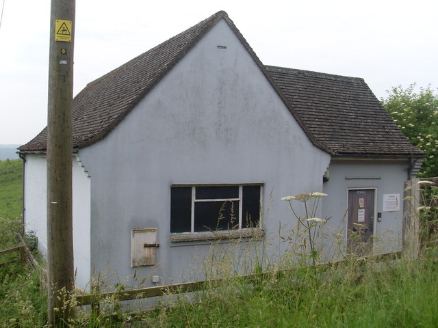
Ampleforth Telephone Exchange This TE is situated East of Ampleforth Abbey and College on the road to Oswaldkirk. Its postcode is YO62 4HB.
Ampleforth Telephone Exchange
This TE is situated East of Ampleforth Abbey and College on the road to Oswaldkirk. Its postcode is YO62 4HB.
Ampleforth College Tennis Courts
Savill Field 2002 - Ampleforth College sports facilities
Ampleforth College Cricket Scoreboard
Golden Square Campsite Most of the site is set within a small valley and is hidden to view. The camp admin building, shop and main toilet block are the buildings at centre of picture.
Golden Square Campsite
Most of the site is set within a small valley and is hidden to view. The camp admin building, shop and main toilet block are the buildings at centre of picture.
Arable field near Oswaldkirk The field is sown with a cereal crop.  The hedge divides the field from the road.
Arable field near Oswaldkirk
The field is sown with a cereal crop. The hedge divides the field from the road.
West towards Ampleforth
Track at Windmill Farm The track runs almost dead straight until it meets a public footpath that drops into Ampleforth. However, there is no indication that this is a right of way.
Track at Windmill Farm
The track runs almost dead straight until it meets a public footpath that drops into Ampleforth. However, there is no indication that this is a right of way.
Track into Dropping Gill Forest track that follows the edge of a small valley.
Track into Dropping Gill
Forest track that follows the edge of a small valley.
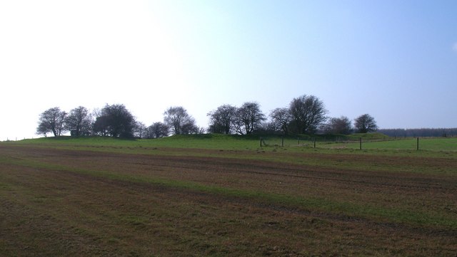
Studfold Ring Seen from the east, this feature appears as a low bank with small trees on and within the earthwork.  One would assume that this is a prehistoric site, but it appears to be largely medieval and would have been used as some sort of corral for horses.
Studfold Ring
Seen from the east, this feature appears as a low bank with small trees on and within the earthwork. One would assume that this is a prehistoric site, but it appears to be largely medieval and would have been used as some sort of corral for horses.
Studfold Ring - outer bank The map shows this earthwork as a circle, but the shape is more of a rectangle with rounded off corners [perhaps based on the design of the Austin Allegro steering wheel?]. Not a defensive site, due to the flat surroundings and a ditch inside the outer bank, but actually a medieval horse enclosure.
Studfold Ring - outer bank
The map shows this earthwork as a circle, but the shape is more of a rectangle with rounded off corners [perhaps based on the design of the Austin Allegro steering wheel?]. Not a defensive site, due to the flat surroundings and a ditch inside the outer bank, but actually a medieval horse enclosure.
Inside Studfold Ring Looking across the flat inner area of the ring with the ditch and bank visible around the perimeter. Studford Farm visible beyond.
Note that the feature is shown as Studford Ring on the 1:50000 map and is also known as Stotfold Ring. The term 'stud' associates it with horses, as this was a medieval horse enclosure.
Inside Studfold Ring
Looking across the flat inner area of the ring with the ditch and bank visible around the perimeter. Studford Farm visible beyond. Note that the feature is shown as Studford Ring on the 1:50000 map and is also known as Stotfold Ring. The term 'stud' associates it with horses, as this was a medieval horse enclosure.
A sign for the Howardian Hill
A path leading to Ampleforth
Ampleforth Abbey, 2011 <span class="nowrap"><a title="http://www.abbey.ampleforth.org.uk/" rel="nofollow ugc noopener" href="http://www.abbey.ampleforth.org.uk/">Link</a><img style="margin-left:2px;" alt="External link" title="External link - shift click to open in new window" src="https://s1.geograph.org.uk/img/external.png" width="10" height="10"/></span>
Ampleforth Abbey, 2011
Monastery West Wing, Ampleforth Abbey The largest Benedictine community in Britain.
Monastery West Wing, Ampleforth Abbey
The largest Benedictine community in Britain.
Show me another place!

Studford Ring is located at Grid Ref: SE5879 (Lat: 54.207, Lng: -1.103)

Division: North Riding

What 3 Words

///herring.forwarded.prongs. Near Helmsley, North Yorkshire

Nearby Locations

Studford Ring

Related Wikis

Ampleforth

Ampleforth is a village and civil parish in North Yorkshire, England, 20 miles (32 km) north of York. The village is situated on the edge of the North...

Ampleforth Abbey

Ampleforth Abbey is a monastery of Benedictine monks a mile to the east of Ampleforth, North Yorkshire, England, part of the English Benedictine Congregation...

Ampleforth College

Ampleforth College is a co-educational fee-charging boarding and day school in the English boarding school tradition. It opened in 1802 as a boys' school...

Ampleforth railway station

Ampleforth railway station, served the village of Ampleforth, in the Northern English county of North Yorkshire. It was located on a line which ran from...

Nearby Amenities

Located within 500m of 54.207,-1.103
Barrier: stile
Step Count: 2
Stile: stepover
Lat/Long: 54.2035759/-1.1073132
Barrier: stile
Dog Gate: yes
Step Count: 1
Stile: stepover
Lat/Long: 54.203453/-1.1012969
The data included in this document is from www.openstreetmap.org. The data is made available under ODbL.

Have you been to Studford Ring?

Leave your review of Studford Ring below (or comments, questions and feedback).