Stane Street

Heritage Site in Surrey Mole Valley

England

Stane Street

Footpath junction, Betchets Green Holmwood footpath 525 goes straight on along the drive to Redlands, footpath 266 goes right.
Footpath junction, Betchets Green Credit: Robin Webster

Stane Street, located in Surrey, England, is a historic heritage site that holds significant importance in the region's history. It is an ancient Roman road that was constructed around 70 AD during the Roman occupation of Britain. Stane Street originally connected Londinium (modern-day London) with Noviomagus Reginorum (now known as Chichester).

The road stretches for approximately 55 miles and runs in a straight line through the southern part of Surrey. It is believed to have been built by the Roman army as a means of connecting important settlements and military forts in the area. Stane Street was constructed with a solid foundation of gravel, topped with large stone slabs, making it durable and able to withstand heavy traffic.

Throughout the centuries, Stane Street has witnessed various changes and modifications, but its general route has remained largely intact. Today, parts of the road can still be seen and walked upon, providing visitors with a glimpse into its ancient past. Some sections of Stane Street are protected as Scheduled Monuments due to their historical significance.

As a heritage site, Stane Street offers a unique opportunity to explore the Roman influence on the region. It serves as a reminder of the extensive road network developed by the Romans and their engineering prowess. Visitors can experience the sense of history and imagine the Roman soldiers and traders who once traveled along this important route. Stane Street stands as an enduring testament to the enduring legacy of the Roman Empire in Britain.

If you have any feedback on the listing, please let us know in the comments section below.
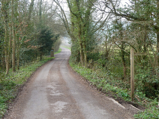
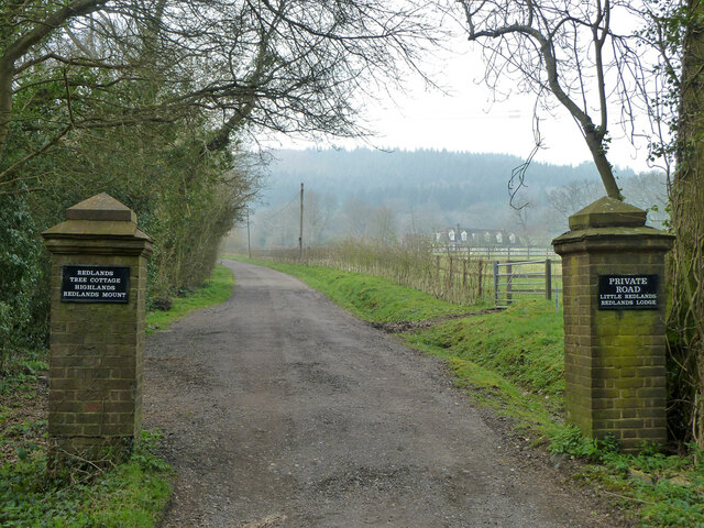
Stane Street Images

Images are sourced within 2km of 51.205/-0.332 or Grid Reference TQ1646. Thanks to Geograph Open Source API. All images are credited.

Footpath junction, Betchets Green Holmwood footpath 525 goes straight on along the drive to Redlands, footpath 266 goes right.
Footpath junction, Betchets Green
Holmwood footpath 525 goes straight on along the drive to Redlands, footpath 266 goes right.
Drive to Redlands and other places A private road but public footpath 525, Holmwood.
Drive to Redlands and other places
A private road but public footpath 525, Holmwood.
Public footpath 266, Holmwood From Betchets Green to Warwick Road, South Holmwood.
Public footpath 266, Holmwood
From Betchets Green to Warwick Road, South Holmwood.
Public footpath 266, Holmwood From Betchets Green to Warwick Road, South Holmwood.
Public footpath 266, Holmwood
From Betchets Green to Warwick Road, South Holmwood.
North end of public footpath 266, Holmwood At Warwick Close.
North end of public footpath 266, Holmwood
At Warwick Close.
Holmwood Common, near Holmwood Corner, South Holmwood, Surrey - Mixed Broadleaf Woodland With Extensive Undergrowth Holmwood Common is woodland on clay. The area proved relatively difficult to cultivate otherwise, and so was left to grow native species in earlier centuries. After industrialisation, part of the area was used to extract clay for a brickworks on the site, but all signs of that have now gone. The picture shows the typical nature of the woodland on the common. This was taken at the start of an orienteering event.
Holmwood Common, near Holmwood Corner, South Holmwood, Surrey - Mixed Broadleaf Woodland With Extensive Undergrowth
Holmwood Common is woodland on clay. The area proved relatively difficult to cultivate otherwise, and so was left to grow native species in earlier centuries. After industrialisation, part of the area was used to extract clay for a brickworks on the site, but all signs of that have now gone. The picture shows the typical nature of the woodland on the common. This was taken at the start of an orienteering event.
Fourwents Pond, Holmwood Common
The Plough public house, Blackbrook
Viewpoint at Holmwood Common Shows spire of church at Ranmore Common on horizon
Viewpoint at Holmwood Common
Shows spire of church at Ranmore Common on horizon
North Holmwood Church Taken from the west in the village at the bottom of the hill
North Holmwood Church
Taken from the west in the village at the bottom of the hill
Mile House Cottages, Coldharbour Lane looking south
Mile House Cottages, Coldharbour Lane
looking south
Coldharbour Lane: the turning for Chadhurst Farm looking south-west
Coldharbour Lane: the turning for Chadhurst Farm
looking south-west
Logmore Lane looking NNW
Logmore Lane
looking NNW
North Holmwood Village Pond Looking North towards the pond and village.
North Holmwood Village Pond
Looking North towards the pond and village.
Detail of North Holmwood Church Looking East from Flint Hill.
Detail of North Holmwood Church
Looking East from Flint Hill.
Royal Oak Pub Chart Lane South, Dorking.
Royal Oak Pub
Chart Lane South, Dorking.
Redlands Farm Facing North from the track
Redlands Farm
Facing North from the track
Redlands Wood On a beautiful, sunny, January afternoon.
Redlands Wood
On a beautiful, sunny, January afternoon.
Show me another place!

Stane Street is located at Grid Ref: TQ1646 (Lat: 51.205, Lng: -0.332)

Administrative County: Surrey

District: Mole Valley

Police Authority: Surrey

What 3 Words

///loving.foil.prices. Near Holmwood, Surrey

Related Wikis

A24 road (England)

The A24 is a major road in England that runs for 53.2 miles (85.6 km) from Clapham in south-west London to Worthing on the English Channel in West Sussex...

South Holmwood

South Holmwood () is a semi-rural village in Surrey, England. It can be considered cognate with its wider civil parish, which stretches to the east to...

Inholms Clay Pit

Inholms Clay Pit is a 8.4-hectare (21-acre) Local Nature Reserve south of Dorking in Surrey. It is owned by Mole Valley District Council and from 2009...

North Holmwood

North Holmwood is a residential area on the outskirts of Dorking, in Surrey, England. The village is accessible from the A24, the village's historic heart...

Goodwyns

Goodwyns is a housing estate in Dorking, a market town in Surrey, England. It is on the return slope of one of two hillsides of the town and adjoins North...

Glory Wood and Devil's Den

Glory Wood and Devil's Den is a 13-hectare (32-acre) nature reserve south-east of Dorking in Surrey. It is owned by Mole Valley District Council, and...

Wotton Hundred

The Hundred of Wotton, Wotton Hundred or Dorking Hundred was a hundred in Surrey, England. The hundred comprised a south-central portion of the county...

St Joseph's Church, Dorking

St Joseph's Church is a Roman Catholic Church in Dorking, Surrey. It was founded in 1872 with help from the Duke of Norfolk. It is situated in Falkland...

Nearby Amenities

Located within 500m of 51.205,-0.332
264
Source: GPS waypoint
Upload Tag: ojw_surrey_hills
Lat/Long: 51.2044937/-0.3286418
265
Source: GPS waypoint
Upload Tag: ojw_surrey_hills
Lat/Long: 51.2037897/-0.3294211
266
Source: GPS waypoint
Upload Tag: ojw_surrey_hills
Lat/Long: 51.2047035/-0.3275347
267
Source: GPS waypoint
Upload Tag: ojw_surrey_hills
Lat/Long: 51.2056825/-0.3258532
268
Source: GPS waypoint
Upload Tag: ojw_surrey_hills
Lat/Long: 51.2058152/-0.325641
Bus Stop
Norfolk Lane
Bus: yes
Naptan AtcoCode: 40004408077A
Naptan Bearing: SE
Naptan CommonName: Norfolk Lane
Naptan Indicator: Opp
Naptan Landmark: Norfolk Lane
Naptan NaptanCode: surawtwt
Naptan Street: Horsham Road
Naptan Verified: no
Public Transport: platform
Source: naptan_import
Lat/Long: 51.2024385/-0.3287642
Bus Stop
Norfolk Lane
Bench: yes
Bus: yes
Naptan AtcoCode: 40004408077B
Naptan Bearing: NW
Naptan CommonName: Norfolk Lane
Naptan Indicator: Just after
Naptan Landmark: Norfolk Lane
Naptan NaptanCode: surdadad
Naptan Street: Horsham Road
Naptan Verified: yes
Public Transport: platform
Shelter: yes
Lat/Long: 51.2030901/-0.3294765
Bus Stop
Spook Hill
Bus: yes
Naptan AtcoCode: 40004408078B
Naptan Bearing: NW
Naptan CommonName: Little Chef
Naptan Indicator: adj
Naptan Landmark: Little Chef
Naptan NaptanCode: surdadap
Naptan Street: Horsham Road
Naptan Verified: yes
Public Transport: platform
Lat/Long: 51.2062169/-0.3311233
Barrier: kissing_gate
Lat/Long: 51.2014143/-0.3328908
Post Box
Operator: Royal Mail
Ref: RH5 8
Source: Only seen when checking photo P143-0662
Lat/Long: 51.2030495/-0.3294446
Mid Holmwood
Place: village
Lat/Long: 51.2025171/-0.3284061
Barrier: kissing_gate
Lat/Long: 51.2073591/-0.3317206
Barrier: stile
Lat/Long: 51.2081146/-0.3356954
Barrier: stile
Lat/Long: 51.2038418/-0.3268016
Norfolk Lane
Bus: yes
Public Transport: stop_position
Lat/Long: 51.2024312/-0.3288481
Norfolk Lane
Bus: yes
Public Transport: stop_position
Lat/Long: 51.2031022/-0.3294072
Spook Hill
Bus: yes
Public Transport: stop_position
Lat/Long: 51.2058482/-0.3306104
Spook Hill
Bus: yes
Public Transport: stop_position
Lat/Long: 51.206235/-0.3310321
Power: pole
Lat/Long: 51.2086512/-0.3357589
Power: pole
Lat/Long: 51.2074497/-0.3355685
Power: pole
Lat/Long: 51.2071825/-0.3349784
Power: pole
Lat/Long: 51.206423/-0.3354076
Power: pole
Lat/Long: 51.2050601/-0.3351876
Power: pole
Lat/Long: 51.2042602/-0.3350508
Power: pole
Lat/Long: 51.2023326/-0.3347316
Power: pole
Lat/Long: 51.2014906/-0.3346056
Power: pole
Lat/Long: 51.2062095/-0.3330821
Power: pole
Lat/Long: 51.2080967/-0.3354988
Power: pole
Lat/Long: 51.203798/-0.333361
Power: pole
Lat/Long: 51.2034989/-0.3342193
Power: pole
Lat/Long: 51.2032031/-0.3352144
Power: pole
Lat/Long: 51.2029325/-0.3360727
Power: pole
Lat/Long: 51.2025748/-0.3372917
Power: pole
Lat/Long: 51.2019376/-0.3328273
Bus Stop
Spook Hill
Bus: yes
Naptan AtcoCode: 40004408078A
Naptan Bearing: SE
Naptan CommonName: Little Chef
Naptan Indicator: Opp
Naptan Landmark: Little Chef
Naptan NaptanCode: surdadam
Naptan Street: Horsham Road
Naptan Verified: yes
Public Transport: platform
Source: naptan_import
Lat/Long: 51.2058568/-0.3304946
Redlands Farm
Place: farm
Lat/Long: 51.2035061/-0.3373734
Addr Housenumber: 1
Lat/Long: 51.2009137/-0.3295159
Addr Housenumber: 2
Lat/Long: 51.2009211/-0.3296012
Addr Housenumber: 1
Lat/Long: 51.2012577/-0.3293156
Addr Housenumber: 2
Lat/Long: 51.2012386/-0.3294099
Addr Housenumber: 3
Lat/Long: 51.2012181/-0.3295257
Addr Housenumber: 4
Lat/Long: 51.2012207/-0.3296725
Addr Housename: St Nicholas
Lat/Long: 51.2011661/-0.3294595
Crossing
Lat/Long: 51.2014727/-0.3321428
Addr Housename: Dahinda
Lat/Long: 51.2020458/-0.3291637
Addr Housename: Whitegates2
Lat/Long: 51.2021474/-0.3291662
Natural: spring
Lat/Long: 51.2011609/-0.331832
Addr Housename: Meadowbank
Lat/Long: 51.2025798/-0.3301906
Addr Housename: Oakbank
Lat/Long: 51.2025777/-0.3302648
Addr Housename: Woodlands View
Addr Housenumber: 1
Lat/Long: 51.2023248/-0.3307666
Addr Housename: Woodlands View
Addr Housenumber: 2
Lat/Long: 51.202251/-0.3307959
Addr Housename: Woodland Villas
Addr Housenumber: 1
Lat/Long: 51.2025527/-0.3303813
Addr Housename: Woodland Villas
Addr Housenumber: 2
Lat/Long: 51.2025468/-0.3304592
Addr Housename: Pennyhall
Lat/Long: 51.2022866/-0.3321842
Addr Housenumber: 1
Lat/Long: 51.2023688/-0.3318895
Addr Housenumber: 4
Lat/Long: 51.2023516/-0.3317065
Addr Housenumber: 7
Lat/Long: 51.2021303/-0.3314729
Addr Housenumber: 11
Lat/Long: 51.2019374/-0.3315002
Addr Housenumber: 13
Lat/Long: 51.2018248/-0.3316215
Addr Housenumber: 15
Lat/Long: 51.20174/-0.3315666
Addr Housenumber: 2
Lat/Long: 51.2035959/-0.3322392
Addr Housenumber: 1
Lat/Long: 51.2035973/-0.3321119
Addr Housenumber: 8
Lat/Long: 51.2035867/-0.3318378
Addr Housename: Holmside Cottages
Lat/Long: 51.2035187/-0.332083
Addr Housenumber: 3
Lat/Long: 51.2035758/-0.3313066
Addr Housename: Stane Cottage
Lat/Long: 51.2062623/-0.3314134
Addr Housename: Rosewood Cottage
Lat/Long: 51.2061406/-0.3313915
The data included in this document is from www.openstreetmap.org. The data is made available under ODbL.

Have you been to Stane Street ?

Leave your review of Stane Street below (or comments, questions and feedback).