Middleforth Green

Settlement in Lancashire South Ribble

England

Middleforth Green
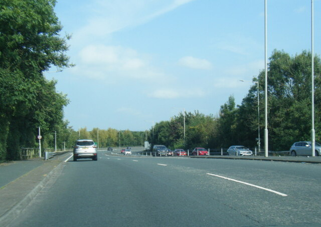
A6 London Way, northbound
A6 London Way, northbound Credit: Colin Pyle

Middleforth Green is a small village located in the county of Lancashire, in the northwest of England. Situated approximately 3 miles south of the city of Preston, Middleforth Green falls within the administrative boundaries of South Ribble Borough Council. The village is set amidst picturesque countryside, surrounded by green fields and farmland, providing residents with a tranquil and idyllic setting.

Despite its rural charm, Middleforth Green benefits from its close proximity to the amenities and services offered by the nearby city of Preston. The village itself is primarily residential, with a mix of traditional cottages and more modern houses. The community is tight-knit, fostering a strong sense of belonging among its residents.

Middleforth Green is well-connected to the rest of Lancashire and beyond, with convenient transport links. The M6 motorway is easily accessible, allowing for easy travel to Manchester and Liverpool. Additionally, Preston Railway Station provides regular services to major cities in the UK.

The village is home to a number of local businesses, including a post office, a convenience store, and a pub, which serves as a social hub for the community. Nearby, residents can enjoy recreational activities at several parks and green spaces, perfect for leisurely walks or picnics.

Overall, Middleforth Green offers a peaceful and friendly environment, making it an attractive place to reside for those seeking a rural lifestyle while still having access to urban amenities.

If you have any feedback on the listing, please let us know in the comments section below.

Middleforth Green Images

Images are sourced within 2km of 53.74186/-2.710305 or Grid Reference SD5327. Thanks to Geograph Open Source API. All images are credited.

A6 London Way, northbound
Preston Station Preston features some elaborate decorative ironwork.
Preston Station
Preston features some elaborate decorative ironwork.
Fishergate, Preston Fishergate is a shopping street in the centre of Preston.  Signs indicate that the road is closed to traffic, other than buses, taxis and bicycles.
Fishergate, Preston
Fishergate is a shopping street in the centre of Preston. Signs indicate that the road is closed to traffic, other than buses, taxis and bicycles.
Winckley Street, Preston Winckley Street in the centre of Preston.
Winckley Street, Preston
Winckley Street in the centre of Preston.
Fishergate, Preston Fishergate is a shopping street in the centre of Preston.  The street is part-pedestrianised, although buses, taxis and cyclists are still permitted to use it.
Fishergate, Preston
Fishergate is a shopping street in the centre of Preston. The street is part-pedestrianised, although buses, taxis and cyclists are still permitted to use it.
Preston railway station The station approach and main station building at Preston railway station.
Preston railway station
The station approach and main station building at Preston railway station.
Fishergate, Preston A view of Fishergate, in Preston.
Fishergate, Preston
A view of Fishergate, in Preston.
The Station pub, Preston The Station pub in Preston.  As its name suggests, the pub is located next to Preston's railway station.
The Station pub, Preston
The Station pub in Preston. As its name suggests, the pub is located next to Preston's railway station.
Houses in Preston Euston Street to the left, Fitzroy Street to the right, with the ends of terraces to the right.
Houses in Preston
Euston Street to the left, Fitzroy Street to the right, with the ends of terraces to the right.
Hartington Road With Northcote Road joining from the left. An area of terraced housing dating from the mid-1800s. The nearest house, with post box, was a corner shop [Google Street View imagery, 2014]. The Northcote Road wall has the remains of a 'Gold Flake cigarettes' advertisement - see <a href="https://www.geograph.org.uk/photo/7002287">SD5229 : GOLD FLAKE CIGARETTES</a>.
Hartington Road
With Northcote Road joining from the left. An area of terraced housing dating from the mid-1800s. The nearest house, with post box, was a corner shop [Google Street View imagery, 2014]. The Northcote Road wall has the remains of a 'Gold Flake cigarettes' advertisement - see SD5229 : GOLD FLAKE CIGARETTES.
GOLD FLAKE CIGARETTES Legacy advertising, on the Northcote Road end of a Hartington Road terrace house that was once a corner shop <a href="https://www.geograph.org.uk/photo/7002272">SD5229 : Hartington Road</a>.
GOLD FLAKE CIGARETTES
Legacy advertising, on the Northcote Road end of a Hartington Road terrace house that was once a corner shop SD5229 : Hartington Road.
Access to the bins In this area of terraced houses the narrow back lanes between each pair of parallel terraces are gated, presumably for security.
Access to the bins
In this area of terraced houses the narrow back lanes between each pair of parallel terraces are gated, presumably for security.
Waterstones, Fishergate, Preston A Grade II building, 6 Fishergate, built in 1859, and now a bookshop. The upper floors were refaced in 1915. <span class="nowrap"><a title="https://historicengland.org.uk/listing/the-list/list-entry/1279821" rel="nofollow ugc noopener" href="https://historicengland.org.uk/listing/the-list/list-entry/1279821">Link</a><img style="margin-left:2px;" alt="External link" title="External link - shift click to open in new window" src="https://s1.geograph.org.uk/img/external.png" width="10" height="10"/></span>.
Waterstones, Fishergate, Preston
A Grade II building, 6 Fishergate, built in 1859, and now a bookshop. The upper floors were refaced in 1915. LinkExternal link.
Stagecoach to Southport Fishergate, a long, straight shopping street that has been nicely pedestrianised in central Preston. Many of the buildings date back to the mid-late 19th Century.
Stagecoach to Southport
Fishergate, a long, straight shopping street that has been nicely pedestrianised in central Preston. Many of the buildings date back to the mid-late 19th Century.
Mount Street, Preston A narrow one-way street from here; looking north from its junction with Fishergate,
Mount Street, Preston
A narrow one-way street from here; looking north from its junction with Fishergate,
Brucciani - Grand Cafe - interior An old-fashioned cafe with beautiful decor in the heart of Preston, established in 1932, and great for coffee, brunch etc.
Brucciani - Grand Cafe - interior
An old-fashioned cafe with beautiful decor in the heart of Preston, established in 1932, and great for coffee, brunch etc.
Brucciani - Grand Cafe  An old-fashioned cafe with beautiful decor in the heart of Preston, established in 1932, and great for coffee, brunch etc. Near the western end of Fishergate.
Brucciani - Grand Cafe
An old-fashioned cafe with beautiful decor in the heart of Preston, established in 1932, and great for coffee, brunch etc. Near the western end of Fishergate.
Car parks, Preston These car parks, close to the centre of Preston, occupy the site of a former railway goods yard.
Car parks, Preston
These car parks, close to the centre of Preston, occupy the site of a former railway goods yard.
Show me another place!

Middleforth Green is located at Grid Ref: SD5327 (Lat: 53.74186, Lng: -2.710305)

Administrative County: Lancashire

District: South Ribble

Police Authority: Lancashire

What 3 Words

///thinks.wounds.second. Near Preston, Lancashire

Nearby Locations

Middleforth Green

Related Wikis

Penwortham

Penwortham () is a town and civil parish in South Ribble, Lancashire, England, on the south bank of the River Ribble facing the city of Preston. The town...

Penwortham Old Bridge

Penwortham Old Bridge is a toll-free, five-span bridge over the River Ribble at Preston, Lancashire, England. A Grade II listed structure and a Scheduled...

West Cliff, Preston

West Cliff is a cricket ground in Preston, Lancashire. The first recorded match on the ground was in 1870, when Preston played a United North of England...

Penwortham Cop Lane railway station

Penwortham Cop Lane was a railway station on the West Lancashire Railway in England. It served the town of Penwortham in Lancashire. It was between Higher...

Nearby Amenities

Located within 500m of 53.74186,-2.710305
Mini Roundabout
Direction: clockwise
Lat/Long: 53.7430885/-2.7102704
Pub
Pear Tree
Addr City: Preston
Addr District: Penwortham
Addr Housenumber: 155
Addr Postcode: PR1 9QB
Addr Street: Leyland Road
Fhrs Id: 1082515
Lat/Long: 53.73999/-2.7069899
Barrier: bollard
Bicycle: yes
Foot: yes
Horse: yes
Motor Vehicle: no
Lat/Long: 53.7429889/-2.7097787
Turning Circle
Lat/Long: 53.7455345/-2.7093983
Barrier: bollard
Bicycle: yes
Foot: yes
Horse: yes
Lat/Long: 53.7436846/-2.7138169
Note: FIXME
Lat/Long: 53.7394104/-2.7139287
Turning Circle
Lat/Long: 53.7394583/-2.7081979
Middleforth Junction
Railway: junction
Lat/Long: 53.7449251/-2.7124079
Crossing
Crossing: traffic_signals
Crossing Island: no
Crossing Ref: pelican
Tactile Paving: yes
Lat/Long: 53.7442365/-2.7103885
Middleforth Green
Place: neighbourhood
Short Name: Middleforth
Lat/Long: 53.7437483/-2.7101475
Post Box
Collection Times: Mo-Fr 09:00, Sa 07:00
Operator: Royal Mail
Operator Wikidata: Q638098
Post Box Design: type_k
Post Box Type: pillar
Ref: PR1 216
Royal Cypher: EIIR
Royal Cypher Wikidata: Q33102113
Lat/Long: 53.7445083/-2.7103817
Give Way
Direction: forward
Lat/Long: 53.7384596/-2.7138825
Give Way
Direction: backward
Lat/Long: 53.7391924/-2.7069893
Give Way
Direction: forward
Lat/Long: 53.7418652/-2.7129628
Give Way
Direction: forward
Lat/Long: 53.738609/-2.7096547
Railway: signal
Railway Signal Direction: forward
Railway Signal Main: GB-NR:main
Railway Signal Main Design: individual
Railway Signal Main Form: light
Railway Signal Main States: red;green;yellow;flashing_yellow;double_yellow;flashing_double_yellow
Railway Signal Operator: Network Rail
Railway Signal Position: bridge
Railway Signal Route: GB-NR:junction
Railway Signal Route Design: feather
Railway Signal Route Form: light
Railway Signal Route States: position_1;position_2;position_3;position_4
Ref: PN 76
Lat/Long: 53.7441202/-2.7050276
Railway: signal
Railway Signal Direction: forward
Railway Signal Main: GB-NR:main
Railway Signal Main Design: individual
Railway Signal Main Form: light
Railway Signal Main States: red;green;yellow;flashing_yellow;double_yellow;flashing_double_yellow
Railway Signal Operator: Network Rail
Railway Signal Position: bridge
Railway Signal Route: GB-NR:junction
Railway Signal Route Design: feather
Railway Signal Route Form: light
Railway Signal Route States: position_1;position_4;position_5;position_6
Ref: PN 75
Lat/Long: 53.7441165/-2.7051249
Railway: signal
Railway Signal Direction: forward
Railway Signal Main: GB-NR:main
Railway Signal Main Design: individual
Railway Signal Main Form: light
Railway Signal Main States: red;green;yellow;flashing_yellow;double_yellow;flashing_double_yellow
Railway Signal Operator: Network Rail
Railway Signal Position: bridge
Lat/Long: 53.7410543/-2.7043953
Railway: signal
Railway Signal Direction: forward
Railway Signal Main: GB-NR:main
Railway Signal Main Design: individual
Railway Signal Main Form: light
Railway Signal Main States: red;green;yellow;flashing_yellow;double_yellow;flashing_double_yellow
Railway Signal Operator: Network Rail
Railway Signal Position: bridge
Lat/Long: 53.7410473/-2.7045006
Railway: signal
Railway Signal Direction: forward
Railway Signal Main: GB-NR:main
Railway Signal Main Design: individual
Railway Signal Main Form: light
Railway Signal Main States: red;green;yellow;flashing_yellow;double_yellow;flashing_double_yellow
Railway Signal Operator: Network Rail
Railway Signal Position: bridge
Lat/Long: 53.7410403/-2.7046121
Post Box
Brand: Royal Mail
Brand Wikidata: Q638098
Brand Wikipedia: en:Royal Mail
Collection Times: Mo-Fr 09:00; Sa 07:00
Operator: Royal Mail
Operator Wikidata: Q638098
Post Box Design: type_b
Post Box Type: pillar
Ref: PR1 310
Royal Cypher: GR
Royal Cypher Wikidata: Q33102273
Source: survey
Lat/Long: 53.7385357/-2.7095444
Bus Stop
School Service Only
Bench: no
Bus: yes
Naptan AtcoCode: 25001139
Naptan Bearing: E
Naptan CommonName: New Lane School Stop
Naptan Indicator: by
Naptan NaptanCode: lanagdja
Public Transport: platform
Ref: lanagdja
Shelter: no
Tactile Paving: no
Lat/Long: 53.7390551/-2.7078891
Bus Stop
School Service Only
Bench: no
Bin: yes
Bus: yes
Naptan AtcoCode: 2500LA00200
Naptan Bearing: W
Naptan CommonName: New lane School Stop
Naptan Indicator: o/s
Naptan NaptanCode: langpgmd
Public Transport: platform
Ref: langpgmd
Shelter: no
Tactile Paving: no
Lat/Long: 53.7389656/-2.7078269
Crossing
Crossing: marked
Crossing Island: no
Tactile Paving: yes
Lat/Long: 53.7385598/-2.706397
Waste Basket
Colour: blue
Material: metal
Operator: South Ribble Borough Council
Source: survey
Waste: trash;dog_excrement
Lat/Long: 53.7389749/-2.7078069
Bus Stop
Studholme Crescent
Bench: no
Bus: yes
Naptan AtcoCode: 250012780
Naptan Bearing: N
Naptan CommonName: Studholme Crescent
Naptan Indicator: by
Naptan NaptanCode: lanajmwj
Public Transport: platform
Ref: lanajmwj
Shelter: no
Tactile Paving: no
Lat/Long: 53.7384691/-2.7096985
Post Box
Brand: Royal Mail
Brand Wikidata: Q638098
Brand Wikipedia: en:Royal Mail
Check Date Collection Times: 2021-02-07
Collection Times: Mo-Fr 09:00; Sa 07:00
Operator: Royal Mail
Operator Wikidata: Q638098
Post Box Type: lamp
Ref: PR1 166
Royal Cypher: EIIR
Royal Cypher Wikidata: Q33102113
Source: survey
Lat/Long: 53.7392024/-2.7135477
Bus Stop
Opp Middleforth Garage
Bus: yes
Departures Board: timetable
Naptan AtcoCode: 2500DCL3235
Naptan Bearing: S
Naptan CommonName: Middleforth Garage
Naptan Indicator: opp
Naptan NaptanCode: landgwgw
Public Transport: platform
Ref: landgwgw
Shelter: yes
Lat/Long: 53.7437336/-2.710136
Morrisons Daily
Brand: Morrisons Daily
Brand Wikidata: Q99752411
Shop: convenience
Website: https://my.morrisons.com/storefinder/61139/morrisons-daily-penwortham-leyland-road
Lat/Long: 53.7393107/-2.7074003
Fast Food
Butties2Go
Check Date Opening Hours: 2021-01-18
Cuisine: sandwich
Fhrs Id: 71309
Opening Hours: Mo-Fr 07:30-15:00; Sa 08:00-14:00; Su 09:00-13:00
Phone: +44 1772 490953
Takeaway: yes
Lat/Long: 53.7392425/-2.7075063
Bus Stop
Bus: yes
Public Transport: platform
Lat/Long: 53.74284/-2.7169398
Bus Stop
Bus: yes
Naptan AtcoCode: 25001138
Naptan NaptanCode: lanagdgw
Public Transport: platform
Lat/Long: 53.7427113/-2.7174389
Bus Stop
Bus: yes
Naptan AtcoCode: 2500IMG1729
Naptan NaptanCode: landtwtj
Public Transport: platform
Lat/Long: 53.7438614/-2.7104118
Asda Express
Addr City: Preston
Addr Country: GB
Addr Housenumber: 138
Addr Postcode: PR1 9QD
Addr Street: Leyland Road
Branch: Middleforth
Brand: Asda Express
Brand Wikidata: Q114826023
Fhrs Id: 1608889
Shop: convenience
Website: https://storelocator.asda.com/north-west/penwortham/138-leyland-road
Lat/Long: 53.7435088/-2.7106384
Bus Stop
Bus: yes
Naptan AtcoCode: 250012780
Naptan Bearing: N
Naptan CommonName: Studholme Crescent
Naptan Indicator: by
Naptan NaptanCode: lanajmwj
Public Transport: platform
Lat/Long: 53.7384691/-2.7096985
Bus Stop
Bus: yes
Naptan AtcoCode: 250012775
Naptan Bearing: W
Naptan CommonName: Moss Acre Road
Naptan Indicator: by
Naptan NaptanCode: lanajmwa
Public Transport: platform
Lat/Long: 53.7383796/-2.7126685
Bus Stop
Bus: yes
Naptan AtcoCode: 25001133
Naptan Bearing: NW
Naptan CommonName: Factory Lane
Naptan Indicator: opp
Naptan NaptanCode: lanagatw
Public Transport: platform
Lat/Long: 53.7416052/-2.7083262
Bus Stop
Bus: yes
Naptan AtcoCode: 2500IMG1729
Naptan Bearing: N
Naptan CommonName: Middleforth Garage
Naptan Indicator: by
Naptan NaptanCode: landtwtj
Public Transport: platform
Lat/Long: 53.7438579/-2.7103958
Bus Stop
Bus: yes
Naptan AtcoCode: 2500LAA16094
Naptan Bearing: W
Naptan CommonName: Middleforth CEPS
Naptan Indicator: adj
Naptan NaptanCode: lanwmdj
Public Transport: platform
Lat/Long: 53.7417369/-2.7133924
Bus Stop
Bus: yes
Naptan AtcoCode: 2500DCL3237
Naptan Bearing: SE
Naptan CommonName: Factory Lane
Naptan Indicator: by
Naptan NaptanCode: landgwja
Public Transport: platform
Lat/Long: 53.7421325/-2.7088202
Bus Stop
Bus: yes
Naptan AtcoCode: 2500DCL3235
Naptan Bearing: S
Naptan CommonName: Middleforth Garage
Naptan Indicator: opp
Naptan NaptanCode: landgwgw
Public Transport: platform
Lat/Long: 53.7437336/-2.710136
Bus Stop
Bus: yes
Naptan AtcoCode: 2500DCL3234
Naptan Bearing: SE
Naptan CommonName: Dove Avenue
Naptan Indicator: by
Naptan NaptanCode: landgwgt
Public Transport: platform
Lat/Long: 53.7453508/-2.7117706
Bus Stop
Bus: yes
Naptan AtcoCode: 2500DCL3232
Naptan Bearing: NE
Naptan CommonName: Marshalls Brow
Naptan Indicator: by
Naptan NaptanCode: landgwgm
Public Transport: platform
Lat/Long: 53.7428553/-2.711228
Bus Stop
Bus: yes
Naptan AtcoCode: 2500LAA16239
Naptan Bearing: W
Naptan CommonName: Marshalls Brow
Naptan Indicator: adj
Public Transport: platform
Lat/Long: 53.742784/-2.7111207
Bus Stop
Bus: yes
Naptan AtcoCode: 250012766
Naptan Bearing: NW
Naptan CommonName: Stricklands Lane
Naptan Indicator: by
Naptan NaptanCode: lanajmtj
Public Transport: platform
Lat/Long: 53.7456418/-2.7127156
Bus Stop
Bus: yes
Naptan AtcoCode: 2500LA00200
Naptan Bearing: W
Naptan CommonName: New lane School Stop
Naptan Indicator: o/s
Naptan NaptanCode: langpgmd
Public Transport: platform
Lat/Long: 53.7389656/-2.7078269
Bus Stop
Bus: yes
Naptan AtcoCode: 2500DCL3238
Naptan Bearing: NW
Naptan CommonName: New Lane
Naptan Indicator: by
Naptan NaptanCode: landgwjd
Public Transport: platform
Lat/Long: 53.7386583/-2.7065937
Bus Stop
Bus: yes
Naptan AtcoCode: 2500DCL3239
Naptan Bearing: SE
Naptan CommonName: New Lane
Naptan Indicator: opp
Naptan NaptanCode: landgwjg
Public Transport: platform
Lat/Long: 53.7383916/-2.706089
Bus Stop
Bus: yes
Naptan AtcoCode: 25001139
Naptan Bearing: E
Naptan CommonName: New Lane School Stop
Naptan Indicator: by
Naptan NaptanCode: lanagdja
Public Transport: platform
Lat/Long: 53.7390551/-2.7078891
The data included in this document is from www.openstreetmap.org. The data is made available under ODbL.

Have you been to Middleforth Green?

Leave your review of Middleforth Green below (or comments, questions and feedback).