Hindhead Commons

Heritage Site in Surrey Waverley

England

Hindhead Commons

Hindhead Common Pine trees and a clearing near the visitor centre at the Devil's Punch Bowl.
Hindhead Common Credit: Ian Taylor

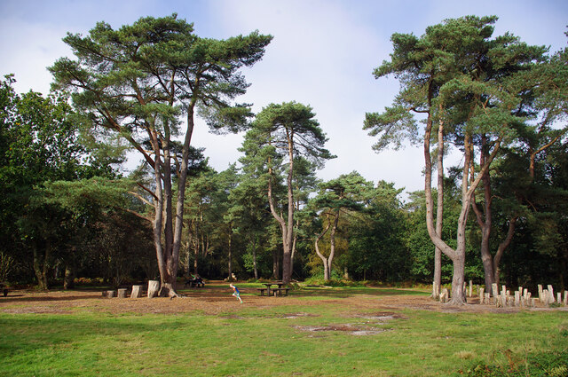
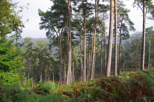
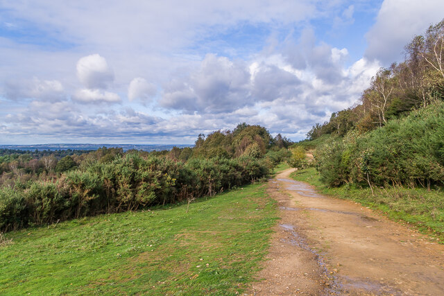
Hindhead Commons, located in Surrey, England, is a renowned heritage site that attracts visitors from all over the world. Covering an area of approximately 520 acres, it is a vast expanse of picturesque heathland and ancient woodland, offering a serene and tranquil escape from the hustle and bustle of city life.

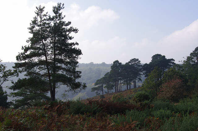
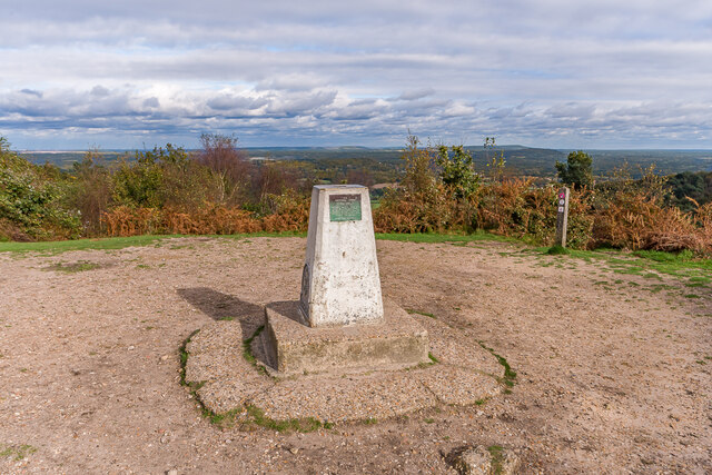
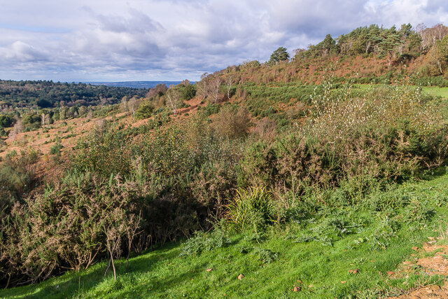
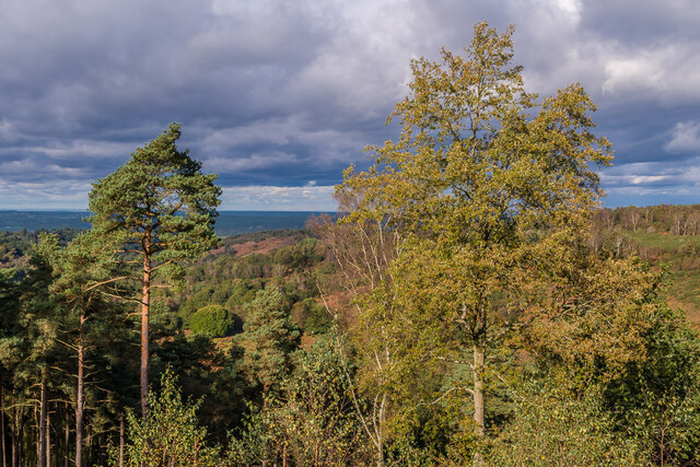
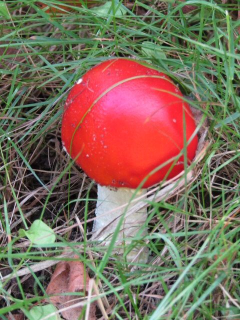
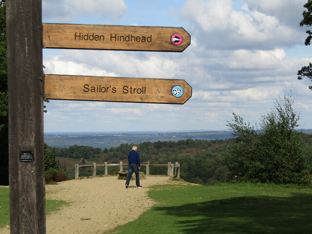
The commons are situated on the slopes of the Hindhead Hill, providing visitors with breathtaking views of the surrounding countryside. The site is a designated Area of Outstanding Natural Beauty, boasting a diverse range of flora and fauna. Visitors can explore the rich biodiversity of the area, encountering native species such as deer, birds, and various reptiles.

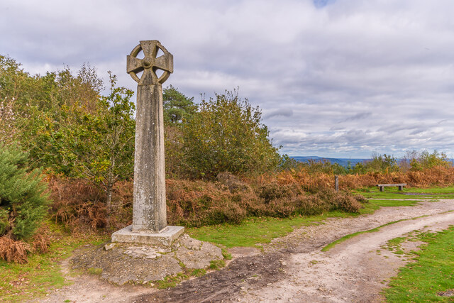
The commons have a significant historical background, with notable features such as the Devil's Punch Bowl, a natural amphitheater formed during the ice age. This geological wonder attracts geology enthusiasts and nature lovers alike. Moreover, Hindhead Commons played a crucial role in the preservation and restoration of the area's heathland, which was once threatened by urban development.

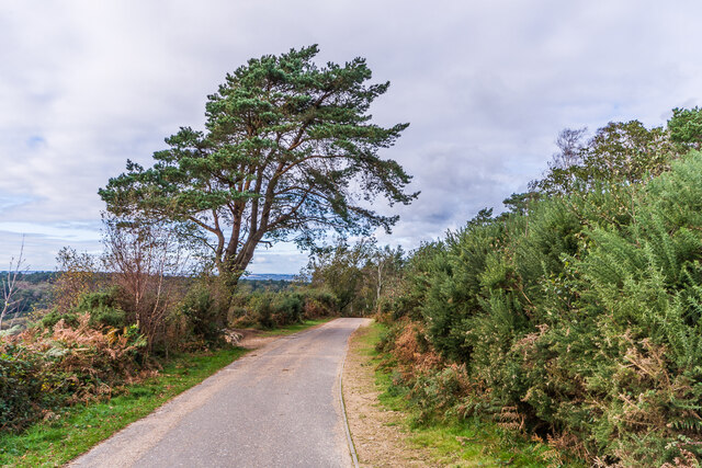
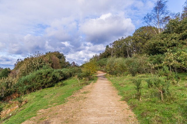
The site offers a multitude of activities for visitors to enjoy. There are several walking trails and footpaths that wind through the commons, allowing visitors to experience the beauty of the landscape up close. Additionally, the area is popular among cyclists and horse riders, with designated routes catering to their interests.

Hindhead Commons also provides educational opportunities, hosting various workshops and guided tours that focus on the conservation efforts and local history. The visitor center offers insightful information about the site's natural and cultural heritage, enhancing the overall experience for visitors.

In summary, Hindhead Commons in Surrey is a captivating heritage site that showcases the beauty of nature and offers a range of activities for visitors to enjoy. Its historical significance, stunning vistas, and diverse wildlife make it a must-visit destination for nature enthusiasts and history buffs alike.

If you have any feedback on the listing, please let us know in the comments section below.

Hindhead Commons Images

Images are sourced within 2km of 51.116/-0.73 or Grid Reference SU8835. Thanks to Geograph Open Source API. All images are credited.

Hindhead Common Pine trees and a clearing near the visitor centre at the Devil's Punch Bowl.
Hindhead Common
Pine trees and a clearing near the visitor centre at the Devil's Punch Bowl.
Devil's Punch Bowl Looking down into the natural bowl.
Devil's Punch Bowl
Looking down into the natural bowl.
Flush bracket S1535 On the trig point on Gibbet Hill (272m). See <a href="https://www.geograph.org.uk/photo/6696717">SU8935 : Gibbet Hill</a>.
Flush bracket S1535
On the trig point on Gibbet Hill (272m). See SU8935 : Gibbet Hill.
Valley at Highcomb Looking across the valley, north of the Devil's Punch Bowl.
Valley at Highcomb
Looking across the valley, north of the Devil's Punch Bowl.
Celtic cross Celtic cross on the summit of Gibbet Hill, erected in 1851 by Sir William Erle near the site of the gallows which were used to hang three sailors who in 1786  had murdered another while he was on his way to Portsmouth.  Grade II listed  - see <span class="nowrap"><a title="www.historicengland.org.uk/listing/the-list/list-entry/1260847" rel="nofollow ugc noopener" href="http://www.historicengland.org.uk/listing/the-list/list-entry/1260847">Link</a><img style="margin-left:2px;" alt="External link" title="External link - shift click to open in new window" src="https://s1.geograph.org.uk/img/external.png" width="10" height="10"/></span>.
Celtic cross
Celtic cross on the summit of Gibbet Hill, erected in 1851 by Sir William Erle near the site of the gallows which were used to hang three sailors who in 1786 had murdered another while he was on his way to Portsmouth. Grade II listed - see LinkExternal link.
Gibbet Hill Trig point on the summit of Gibbet Hill, with the North Downs in the centre background and Leith Hill to their right.  Although not apparent in this photo, very clear conditions on this occasion meant that the City of London skyscrapers could be seen through the Wey Gap, left of centre, a distance of almost 40 miles.
Gibbet Hill
Trig point on the summit of Gibbet Hill, with the North Downs in the centre background and Leith Hill to their right. Although not apparent in this photo, very clear conditions on this occasion meant that the City of London skyscrapers could be seen through the Wey Gap, left of centre, a distance of almost 40 miles.
Byway, Devil's Punchbowl Byway above the Devil's Punch Bowl, giving an alternative route for traffic prohibited from using the A3 Hindhead Tunnel.
Byway, Devil's Punchbowl
Byway above the Devil's Punch Bowl, giving an alternative route for traffic prohibited from using the A3 Hindhead Tunnel.
Old A3, Devil's Punch Bowl Part of the route of the former A3 above the Devil's Punch Bowl, restored to nature following the opening of the Hindhead Tunnel in 2011.
Old A3, Devil's Punch Bowl
Part of the route of the former A3 above the Devil's Punch Bowl, restored to nature following the opening of the Hindhead Tunnel in 2011.
Devil's Punch Bowl Looking along the rim of the Devil's Punch Bowl, with part of the route of the former A3 in the background, restored to nature following the opening of the Hindhead Tunnel in 2011.
Devil's Punch Bowl
Looking along the rim of the Devil's Punch Bowl, with part of the route of the former A3 in the background, restored to nature following the opening of the Hindhead Tunnel in 2011.
Devil's Punch Bowl Looking across the Devil's Punch Bowl.
Devil's Punch Bowl
Looking across the Devil's Punch Bowl.
Looking westwards along London Road Without doubt the biggest event in Hindhead's history was the building of the Hindhead Tunnel, before which this was a notorious bottleneck on the A3. Without doubt the biggest event in the UK was the death of Queen Elizabeth II after 70 years on the throne; although new Prime Minister Liz Truss and her chancellor Kwasi Kwarteng ran it close by introducing a "fiscal event" that saw markets react negatively and wipe out any benefits. On the world stage, Vladimir Putin held spurious referendums in 4 areas he had won from Ukraine, and announced that these would now be part of Russia in perpetuity. The Italians and Swedes chose parties of the right to form their next governments. And in outer space, NASA crashed a spacecraft into an asteroid to see if this could be done if it were ever really needed.
Looking westwards along London Road
Without doubt the biggest event in Hindhead's history was the building of the Hindhead Tunnel, before which this was a notorious bottleneck on the A3. Without doubt the biggest event in the UK was the death of Queen Elizabeth II after 70 years on the throne; although new Prime Minister Liz Truss and her chancellor Kwasi Kwarteng ran it close by introducing a "fiscal event" that saw markets react negatively and wipe out any benefits. On the world stage, Vladimir Putin held spurious referendums in 4 areas he had won from Ukraine, and announced that these would now be part of Russia in perpetuity. The Italians and Swedes chose parties of the right to form their next governments. And in outer space, NASA crashed a spacecraft into an asteroid to see if this could be done if it were ever really needed.
Advertising board in London Road It shows pupils from Churcher's College which celebrates its 300th anniversary this year. Richard Churcher made his fortune with the East India Company.

Every month on the last day, I record the most prominent deaths in the UK and beyond. One death overshadowed all others, that of Her Majesty Queen Elizabeth the Second on the 8th of September at 3:10pm.

Others to depart were: 1st September 2022, boxing legend Earnie Shavers; 2nd September, ASWAD's Drummie Zeb; 6th, armed robber turned author, John McVicar; 8th, Grange Hill's headteacher Mrs McCluskie, actress Gwyneth Powell; 15th, Rugby legend, Eddie Butler; 22nd, Wolf Hall author Hilary Mantel; 23rd the nasty nurse in 'One Flew Over the Cuckoo's Nest' Louise Fletcher; and on the 28th, US Rapper Coolio.
Advertising board in London Road
It shows pupils from Churcher's College which celebrates its 300th anniversary this year. Richard Churcher made his fortune with the East India Company. Every month on the last day, I record the most prominent deaths in the UK and beyond. One death overshadowed all others, that of Her Majesty Queen Elizabeth the Second on the 8th of September at 3:10pm. Others to depart were: 1st September 2022, boxing legend Earnie Shavers; 2nd September, ASWAD's Drummie Zeb; 6th, armed robber turned author, John McVicar; 8th, Grange Hill's headteacher Mrs McCluskie, actress Gwyneth Powell; 15th, Rugby legend, Eddie Butler; 22nd, Wolf Hall author Hilary Mantel; 23rd the nasty nurse in 'One Flew Over the Cuckoo's Nest' Louise Fletcher; and on the 28th, US Rapper Coolio.
Dawn breaks at the old BMW Garage in London Road This month has been mostly pleasant, weather wise. The hot spell promised for early September never materialised. Mostly it was warm and still. Towards the end of the month we caught the tail end of Hurricane Ian. The official Met Office summary is here <span class="nowrap"><a title="https://www.metoffice.gov.uk/binaries/content/assets/metofficegovuk/pdf/weather/learn-about/uk-past-events/summaries/uk_monthly_climate_summary_202209.pdf" rel="nofollow ugc noopener" href="https://www.metoffice.gov.uk/binaries/content/assets/metofficegovuk/pdf/weather/learn-about/uk-past-events/summaries/uk_monthly_climate_summary_202209.pdf">Link</a><img style="margin-left:2px;" alt="External link" title="External link - shift click to open in new window" src="https://s1.geograph.org.uk/img/external.png" width="10" height="10"/></span>
Dawn breaks at the old BMW Garage in London Road
This month has been mostly pleasant, weather wise. The hot spell promised for early September never materialised. Mostly it was warm and still. Towards the end of the month we caught the tail end of Hurricane Ian. The official Met Office summary is here LinkExternal link
Devil's Punch Bowl - Toadstool Red, waxy-looking toadstool, ca 3 inches high, in the grass beside a footpath.
Devil's Punch Bowl - Toadstool
Red, waxy-looking toadstool, ca 3 inches high, in the grass beside a footpath.
Devil's Punch Bowl - Viewpoint New wooden signposts for "Hidden Hindhead" and the "Sailor's Stroll" at the head of this large natural amphitheatre by Hindhead.
Devil's Punch Bowl - Viewpoint
New wooden signposts for "Hidden Hindhead" and the "Sailor's Stroll" at the head of this large natural amphitheatre by Hindhead.
Hindhead - Former A3 Gorse-lined footpath offering panoramic views westwards over the Devil's Punch Bowl.
Hindhead - Former A3
Gorse-lined footpath offering panoramic views westwards over the Devil's Punch Bowl.
Hindhead - Former A3 Gorse-lined footpath offering panoramic views westwards over the Devil's Punch Bowl.
Hindhead - Former A3
Gorse-lined footpath offering panoramic views westwards over the Devil's Punch Bowl.
Show me another place!

Hindhead Commons is located at Grid Ref: SU8835 (Lat: 51.116, Lng: -0.73)

Administrative County: Surrey

District: Waverley

Police Authority: Surrey

What 3 Words

///springing.prawn.optimists. Near Hindhead, Surrey

Related Wikis

Devil's Punch Bowl

The Devil's Punch Bowl is a 282.2-hectare (697-acre) visitor attraction and biological Site of Special Scientific Interest situated just to the east of...

Hindhead

Hindhead is a village in the Waverley district of the ceremonial county of Surrey, England. It is the highest village in the county and its buildings are...
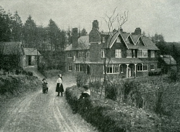
Undershaw

Undershaw is a former residence of the author Sir Arthur Conan Doyle, the creator of Sherlock Holmes. The house was built for Doyle at his order to accommodate...
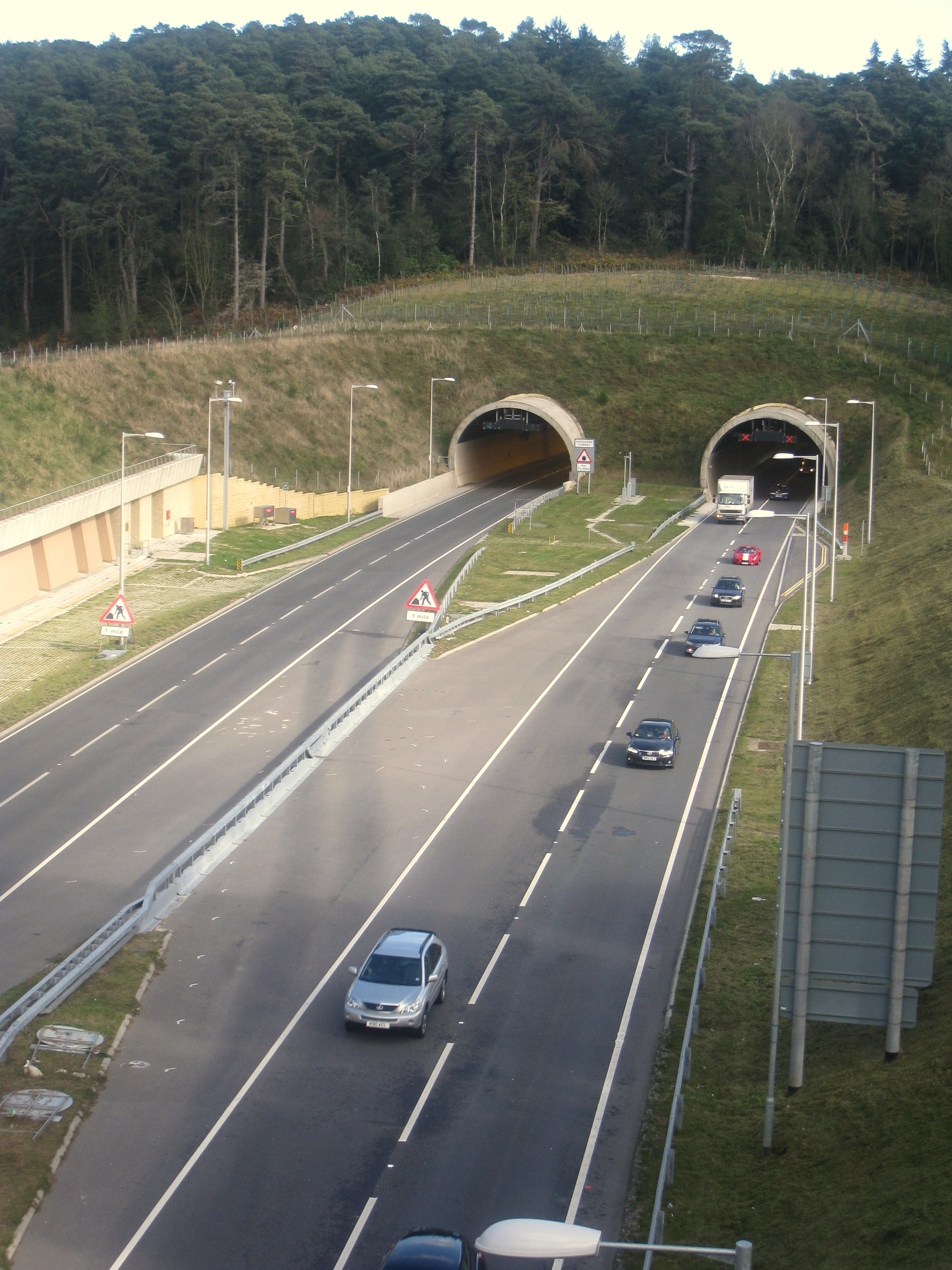
Hindhead Tunnel

The Hindhead Tunnel, opened in 2011, is part of the 4-mile (6.4 km) dual-carriageway that replaced one of the last remaining stretches of single-carriageway...

Gibbet Hill, Hindhead

Gibbet Hill, at Hindhead, Surrey, is the apex of the scarp surrounding the Devil's Punch Bowl, not far from the A3 London to Portsmouth road in England...

St Edmund's School, Hindhead

St Edmund's School is a coeducational nursery, pre-prep, preparatory and senior school located in Hindhead, Surrey, around 10.5 miles south-west from the...

Beacon Hill (Hindhead, Surrey)

Beacon Hill, while ecumenically and administratively part of Hindhead, Surrey, is a discrete settlement with its own history, amenities and character....

Grayshott

Grayshott is a village and civil parish in the East Hampshire district of Hampshire, England. It is on the Hampshire / Surrey border 4 miles (6.4 km) northwest...

Nearby Amenities

Located within 500m of 51.116,-0.73
Tyndall's Wood
Place: locality
Source Name: survey
Lat/Long: 51.1118931/-0.7314809
Hindhead
Place: village
Wikidata: Q3034872
Wikipedia: en:Hindhead
Lat/Long: 51.1132995/-0.7332662
Crossing
Crossing: traffic_signals
Crossing Island: yes
Lat/Long: 51.1136764/-0.73387
Traffic Calming: table
Lat/Long: 51.1138586/-0.732398
Barrier: bollard
Lat/Long: 51.1137894/-0.7290278
Barrier: kissing_gate
Lat/Long: 51.1147734/-0.727071
Devil's Punch Bowl
Place: locality
Source: npe
Wikidata: Q5267212
Wikipedia: en:Devil's Punch Bowl
Lat/Long: 51.1188711/-0.7265031
Devil's Punch Bowl
Tourism: viewpoint
Wheelchair: limited
Wheelchair Description: Level gravel path from car park to panorama, easy for powered chairs. Accessible toilet in cafe.
Lat/Long: 51.1151041/-0.7284149
Parking
Source: sas
Lat/Long: 51.1131983/-0.7323503
Royal Parade Stores
Addr City: Hindhead
Addr Housename: Royal Parade
Addr Postcode: GU26 6TD
Addr Street: Tilford Road
Addr Unit: 6
Fhrs Id: 221583
Shop: convenience
Wheelchair: yes
Lat/Long: 51.1151173/-0.73493
Bus Stop
Crossroads
Bus: yes
Naptan AtcoCode: 40004411112A
Naptan Bearing: NE
Naptan CommonName: Crossroads
Naptan Indicator: Nr
Naptan Landmark: Crossroads
Naptan NaptanCode: surdtmpm
Naptan Street: Portsmouth Road
Naptan Verified: no
Public Transport: platform
Shelter: yes
Source: naptan_import
Wheelchair: yes
Wheelchair Description: Step-free to stop opposite via controlled crossing 25m to North East.
Lat/Long: 51.1135425/-0.7342567
Bus Stop
Royal Parade
Bench: yes
Bin: no
Lit: no
Naptan AtcoCode: 40004411112C
Naptan Bearing: NW
Naptan CommonName: Royal Parade
Naptan Indicator: Just Before
Naptan Landmark: Royal Parade
Naptan NaptanCode: surdtmpw
Naptan Street: Tilford Road
Naptan Verified: no
Shelter: yes
Source: naptan_import
Tactile Paving: no
Wheelchair: yes
Lat/Long: 51.1145891/-0.7342902
Bus Stop
Crossroads
Bus: yes
Naptan AtcoCode: 40004411112D
Naptan Bearing: SW
Naptan CommonName: Crossroads
Naptan Indicator: Just after
Naptan Landmark: Crossroads
Naptan NaptanCode: surdtmta
Naptan Street: Portsmouth Road
Naptan Verified: no
Public Transport: platform
Shelter: yes
Source: naptan_import
Wheelchair: yes
Wheelchair Description: Step-free to stop opposite via controlled crossing 40m to North East.
Lat/Long: 51.1131721/-0.734372
Bus Stop
Royal Parade
Bench: no
Bin: no
Naptan AtcoCode: 40004411112E
Naptan Bearing: SE
Naptan BusStopType: CUS
Naptan CommonName: Royal Parade
Naptan Indicator: Just after
Naptan Landmark: Royal Parade
Naptan NaptanCode: surgpgpt
Naptan Street: Tilford Road
Naptan Verified: no
Shelter: no
Source: naptan_import
Tactile Paving: no
Wheelchair: no
Lat/Long: 51.1146508/-0.7341742
Bus Stop
Tilford Road
Naptan AtcoCode: 40004411267A
Naptan Bearing: SW
Naptan CommonName: Tilford Road
Naptan Indicator: Just after
Naptan Landmark: Tower Road / Tilford Road
Naptan NaptanCode: surdwgjm
Naptan Street: Tower Road
Naptan Verified: no
Source: naptan_import
Lat/Long: 51.1165641/-0.7356364
Post Office
Hindhead Post Office
Addr Postcode: GU26 6TD
Branch: Hindhead
Brand: Post Office
Brand Wikidata: Q1783168
Check Date: 2020-02-20
Contact Website: https://www.postoffice.co.uk/branch-finder/1259237/hindhead
Ref Pol Id: 2125
Wheelchair: yes
Lat/Long: 51.1150677/-0.7349904
Crossing
Crossing: traffic_signals
Crossing Island: no
Lat/Long: 51.1136252/-0.7332271
Bench
Backrest: yes
Material: wood
Seats: 3
Lat/Long: 51.1196866/-0.7334695
Entrance: main
Lat/Long: 51.1143762/-0.7296208
Undershaw
Building: yes
Source: sas
Source Name: local_knowledge
Wikidata: Q7883765
Wikipedia: en:Undershaw
Lat/Long: 51.1132615/-0.733423
Barrier: cycle_barrier
Bicycle: no
Source: survey
Lat/Long: 51.1125048/-0.7298196
Mini Roundabout
Direction: clockwise
Lat/Long: 51.1137906/-0.7333398
Mini Roundabout
Direction: clockwise
Lat/Long: 51.1138259/-0.7336355
Crossing
Crossing: unmarked
Crossing Island: yes
Source: sas; survey
Tactile Paving: yes
Lat/Long: 51.1129894/-0.734807
Fuel
Royal Parade Stores
Compressed Air: no
Operator: Pace
Source: sas
Wheelchair: yes
Lat/Long: 51.1151661/-0.7347871
Disking Computers
Shop: computer
Website: https://www.diskingcomputers.co.uk/hindhead-shop.html
Wheelchair: yes
Lat/Long: 51.1149355/-0.7347799
South West Surrey Conservatives
Office: political_party
Lat/Long: 51.1148732/-0.7347289
Cafe
Stepping Stones Cookie Bar
Addr City: Hindhead
Addr Housename: Royal Parade
Addr Postcode: GU26 6TD
Addr Street: Tilford Road
Addr Unit: 1
Fhrs Id: 352883
Lat/Long: 51.1148109/-0.7346833
Fast Food
Friars
Addr City: Hindhead
Addr Housename: Royal Parade
Addr Postcode: GU26 6TD
Addr Street: Tilford Road
Addr Unit: 4
Fhrs Id: 749763
Fixme: Check type of establishment - unclear from FHRS Open Data.
Wheelchair: yes
Lat/Long: 51.1149995/-0.7348308
The Master Cleaners
Shop: dry_cleaning
Lat/Long: 51.1150752/-0.7348871
Dentist
No.5 Dental Care
Healthcare: dentist
Website: https://www.5dental.co.uk/
Lat/Long: 51.1150517/-0.734871
Post Box
Collection Times: Mo-Fr 17:30; Sa 12:00
Post Box Type: pillar
Ref: GU26 100
Royal Cypher: EIIR
Royal Cypher Wikidata: Q33102113
Source: survey; sas
Lat/Long: 51.113235/-0.7324889
Natural: spring
Source Natural: survey
Lat/Long: 51.1177056/-0.7288832
Crossing
Button Operated: yes
Crossing: traffic_signals
Crossing Island: no
Tactile Paving: yes
Traffic Signals Sound: no
Traffic Signals Vibration: no
Lat/Long: 51.1140192/-0.7337305
Albany Antiques
Addr Street: London Road
Shop: antiques
Wheelchair: limited
Lat/Long: 51.1137188/-0.7329064
Your Little Secret Bridal Boutique
Addr City: Hindhead
Addr Housename: Hindhead Galleries
Addr Postcode: GU26 6SF
Addr Street: Tilford Road
Note: www.yourlittlesecret.co.uk
Opening Hours: "By appointment"
Shop: bridal_boutique
Lat/Long: 51.1140911/-0.7335667
Addr Housenumber: 7
Addr Postcode: GU26 6AB
Addr Street: London Road
Lat/Long: 51.1139507/-0.7330627
Post Box
Check Date Collection Times: 2022-11-16
Collection Times: Mo-Fr 17:30; Sa 12:00
Post Box Type: pillar
Ref: GU26 101
Royal Cypher: EIIR
Royal Cypher Wikidata: Q33102113
Source: survey
Lat/Long: 51.1151233/-0.7348273
Addr City: Hindhead
Addr Housenumber: 15
Addr Postcode: GU26 6AB
Addr Street: London Road
Check Date: 2022-11-16
Disused Shop: yes
Old Name: Custom Cookie Co
Lat/Long: 51.1139308/-0.7327843
Information: guidepost
Tourism: information
Lat/Long: 51.1147811/-0.728549
Hindhead Commons and the Devil's Punch Bowl
Addr City: Hindhead
Addr Postcode: GU26 6AB
Addr Street: London Road
Email: hindhead@nationaltrust.org.uk
Phone: +44 1428 681050
Toilets Wheelchair: yes
Tourism: attraction
Website: https://www.nationaltrust.org.uk/hindhead-and-devils-punchbowl/
Wheelchair: limited
Wheelchair Description: Accessible parking (NT members free), cafe and toilet. Some asphalt paths from car park to views. Mostly gravel paths, many are steep or on a side slope (old A3 grassed over).
Wikidata: Q5267212
Wikipedia: en:Devil's Punch Bowl
Lat/Long: 51.1142343/-0.7289162
Barrier: kissing_gate
Lat/Long: 51.1165693/-0.7307219
Turning Circle
Lat/Long: 51.118332/-0.735076
Barrier: cattle_grid
Lat/Long: 51.1138127/-0.7245148
Drinking Water
Man Made: water_tap
Lat/Long: 51.1143927/-0.7295984
Toilets
Access: yes
Female: yes
Male: yes
Lat/Long: 51.1144259/-0.7297126
Defibrillator
Access: yes
Emergency: defibrillator
Indoor: no
Locked: yes
Lat/Long: 51.114379/-0.7296536
Entrance: yes
Lat/Long: 51.1144671/-0.7295602
Bicycle Parking
Bicycle Parking: event_racking
Lat/Long: 51.1144942/-0.7294262
Information: tactile_map
Map Type: topo
Source: survey
Tourism: information
Wheelchair: limited
Wheelchair Description: Level gravel path from car park to panorama. Tactile relief map is close to ground level. Accessible toilet in cafe.
Lat/Long: 51.1151384/-0.7284157
Toilets
Changing Places
Fee: no
Unisex: yes
Wheelchair: yes
Wheelchair Description: Access from cafe and via path around building to outside door RADAR Key operated magnetic catch on sliding door.
Lat/Long: 51.1145062/-0.7296831
Entrance: yes
Source: survey
Lat/Long: 51.1145076/-0.7297172
Recycling
Recycling Cans: yes
Recycling Cups: yes
Recycling Glass: yes
Recycling Paper: yes
Recycling Plastic: yes
Recycling Trash: yes
Recycling Type: container
Lat/Long: 51.1143577/-0.7294527
Access: yes
Door: hinged
Entrance: main
Lat/Long: 51.1142782/-0.7297519
Information: board
Tourism: information
Lat/Long: 51.1146863/-0.7285237
Tourism: picnic_site
Lat/Long: 51.1153996/-0.729465
Leisure: playground
Lat/Long: 51.1148335/-0.7310091
The data included in this document is from www.openstreetmap.org. The data is made available under ODbL.

Have you been to Hindhead Commons?

Leave your review of Hindhead Commons below (or comments, questions and feedback).