Eastleigh Manor

Heritage Site in Devon North Devon

England

Eastleigh Manor

Fremington: Holmacott Cross On a back route between Barnstaple and Bideford
Fremington: Holmacott Cross Credit: Martin Bodman

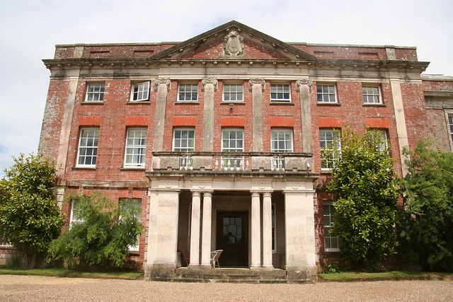
Eastleigh Manor, located in Devon, England, is a prominent heritage site known for its rich historical significance and architectural beauty. Dating back to the 16th century, this manor has witnessed the unfolding of several centuries of British history.

Situated amidst picturesque countryside, Eastleigh Manor showcases a stunning blend of Tudor and Jacobean architectural styles. The manor's exterior features intricate stone masonry, elegant gables, and a grand entrance that reflects the opulence of its era. The interior boasts a wealth of original features such as ornate plasterwork, intricate wood paneling, and exquisite stained glass windows, all meticulously preserved over the centuries.

Throughout its history, Eastleigh Manor has been associated with notable figures and events. It is said that Queen Elizabeth I once visited the manor, leaving her mark on the estate's legacy. The manor has also witnessed the tumultuous English Civil War, with both Royalist and Parliamentarian troops occupying its grounds at different points in time.

Today, Eastleigh Manor is open to the public, offering visitors a unique opportunity to step back in time and explore its rich heritage. Guided tours provide insights into the manor's fascinating history, highlighting its architectural details and significant historical moments. The surrounding grounds offer a tranquil setting for leisurely walks, with well-manicured gardens and scenic views of the surrounding countryside.

Eastleigh Manor stands as a testament to the enduring beauty and historical importance of Devon's heritage. It continues to captivate visitors with its timeless charm and serves as a reminder of the rich cultural tapestry that has shaped the region over the centuries.

If you have any feedback on the listing, please let us know in the comments section below.

Eastleigh Manor Images

Images are sourced within 2km of 51.035/-4.16 or Grid Reference SS4828. Thanks to Geograph Open Source API. All images are credited.

Fremington: Holmacott Cross On a back route between Barnstaple and Bideford
Fremington: Holmacott Cross
On a back route between Barnstaple and Bideford
St Michael's church, Horwood A good solid building with a fine oak lychgate.
St Michael's church, Horwood
A good solid building with a fine oak lychgate.
A39 bridge at Holmacott This is where the new road crosses the old road between Barnstaple and Bideford.
A39 bridge at Holmacott
This is where the new road crosses the old road between Barnstaple and Bideford.
The Forge A house on the western outskirts of Horwood.
The Forge
A house on the western outskirts of Horwood.
A39 Atlantic Highway View west with eastbound traffic near Holmacott.
A39 Atlantic Highway
View west with eastbound traffic near Holmacott.
Raddy Farm Farms and  farm buildings in the geographical area North Devon. (The administrative area governed by North Devon District Council covers a slightly different area.)
Raddy Farm
Farms and farm buildings in the geographical area North Devon. (The administrative area governed by North Devon District Council covers a slightly different area.)
St Michael's church, Horwood The C15 church of St Michael.
St Michael's church, Horwood
The C15 church of St Michael.
St Michael's church, Horwood - effigy of Elizabeth Pollard This effigy of a lady in a horned headdress is thought to be that of Elizabeth Pollard (†1430).
St Michael's church, Horwood - effigy of Elizabeth Pollard
This effigy of a lady in a horned headdress is thought to be that of Elizabeth Pollard (†1430).
St Michael's church, Horwood - effigy of Elizabeth Pollard (detail)
The church of St Michael at Horwood
The A39 half way between Barnstaple and Bideford The farm buildings on the horizon are at Holmacott.
The A39 half way between Barnstaple and Bideford
The farm buildings on the horizon are at Holmacott.
St Michael, Horwood: noticeboard
Ordnance Survey Cut Mark This OS cut mark can be found on the west face of St Michael's Church. It marks a point 104.647m above mean sea level.
Ordnance Survey Cut Mark
This OS cut mark can be found on the west face of St Michael's Church. It marks a point 104.647m above mean sea level.
St Michael, Horwood: churchyard (i)
St Michael, Horwood: churchyard (ii)
St Michael, Horwood: churchyard (iii)
St Michael, Horwood: churchyard (iv)
St Michael, Horwood: coat of arms
Show me another place!

Eastleigh Manor is located at Grid Ref: SS4828 (Lat: 51.035, Lng: -4.16)

Administrative County: Devon

District: North Devon

Police Authority: Devon and Cornwall

What 3 Words

///samples.impulse.showering. Near Appledore, Devon

Related Wikis

Tapeley

Tapeley is a historic estate in the parish of Westleigh in North Devon, England.The present mansion house known as Tapeley Park is a grade II* listed country...

Westleigh, North Devon

Westleigh is a village and civil parish in the North Devon district, in the English County of Devon. Tapeley Park, a country house, is located within the...

Instow

Instow is a village in north Devon, England. It is on the estuary where the rivers Taw and Torridge meet, between the villages of Westleigh and Yelland...

Horwood, Devon

Horwood is a village and former civil parish, now in the parish of Horwood, Lovacott and Newton Tracey, in the North Devon district, in the county of Devon...

Nearby Amenities

Located within 500m of 51.035,-4.16
Power: pole
Lat/Long: 51.0321128/-4.1641403
Power: pole
Lat/Long: 51.0353408/-4.1628957
Power: pole
Lat/Long: 51.0362802/-4.1621206
Material: wood
Power: pole
Lat/Long: 51.0333137/-4.1638855
Power: pole
Lat/Long: 51.0344721/-4.1636065
Power: pole
Lat/Long: 51.0373951/-4.1611845
Power: pole
Lat/Long: 51.0382097/-4.1604952
Power: pole
Lat/Long: 51.0392301/-4.1596664
The data included in this document is from www.openstreetmap.org. The data is made available under ODbL.

Have you been to Eastleigh Manor?

Leave your review of Eastleigh Manor below (or comments, questions and feedback).