Bridgechapel

Heritage Site in Huntingdonshire

England

Bridgechapel

B1040 Potton Road This section was remade to put a bridge over the new A14.
B1040 Potton Road Credit: Hugh Venables

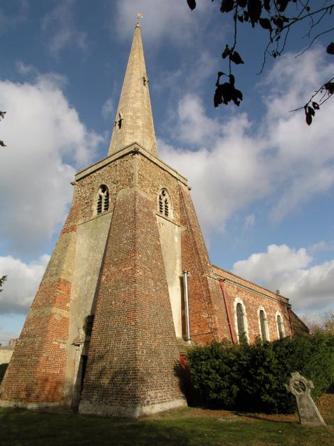
Bridgechapel, located in Huntingdonshire, is a significant heritage site that holds historical, architectural, and cultural importance. This charming and picturesque chapel is nestled amidst the rolling countryside, providing visitors with an idyllic setting to explore and appreciate its rich heritage.

Dating back to the 14th century, Bridgechapel is an exquisite example of medieval architecture. The chapel's structure boasts traditional stone walls, a timber-framed roof, and a beautiful bell tower. It showcases intricate craftsmanship and attention to detail, reflecting the architectural style prevalent during the time of its construction.

The chapel's historical significance lies in its connection to the local community. It has served as a place of worship, a gathering spot for religious ceremonies, and a beacon of faith for centuries. Its walls have witnessed countless weddings, baptisms, and funerals, making it an integral part of the community's social fabric.

Visitors to Bridgechapel can expect a captivating experience. The chapel's interior features stunning stained glass windows, adorned with vibrant colors and intricate designs, adding to its visual allure. The tranquil ambiance invites contemplation and reflection, providing a serene atmosphere for visitors seeking solace or spiritual connection.

Bridgechapel's surroundings further enhance its allure. Set against a backdrop of lush green fields and meandering rivers, the chapel offers breathtaking views and a sense of tranquility rarely found elsewhere. The site's natural beauty, combined with its historical significance, makes it a popular destination for tourists, history enthusiasts, and those seeking a peaceful escape from the bustle of everyday life.

In conclusion, Bridgechapel in Huntingdonshire is a well-preserved heritage site that showcases the region's rich history and architectural heritage. Its medieval charm, historical significance, and picturesque surroundings make it a must-visit destination for anyone seeking to immerse themselves in the region's cultural heritage.

If you have any feedback on the listing, please let us know in the comments section below.

Bridgechapel Images

Images are sourced within 2km of 52.29/-0.072 or Grid Reference TL3167. Thanks to Geograph Open Source API. All images are credited.

B1040 Potton Road This section was remade to put a bridge over the new A14.
B1040 Potton Road
This section was remade to put a bridge over the new A14.
New Lake by West Brook Dug to provide bulk aggregate for the new A14, see <a href="https://www.geograph.org.uk/photo/5970222">TL3067 : Aggregate extraction for A14 construction</a>
New Lake by West Brook
Dug to provide bulk aggregate for the new A14, see TL3067 : Aggregate extraction for A14 construction
Inert waste management facility Woolpack farm Inert waste management facility
Inert waste management facility
Woolpack farm Inert waste management facility
Hilton End Farm Not the end of Hilton parish, but the Hilton end of Fenstanton parish - the parish boundary skirts round the farmstead to exclude it from Hilton.
Hilton End Farm
Not the end of Hilton parish, but the Hilton end of Fenstanton parish - the parish boundary skirts round the farmstead to exclude it from Hilton.
New A14 taking shape From the new B1040 bridge.
New A14 taking shape
From the new B1040 bridge.
Dumper truck by new A14 With one of the extraction pits for the road behind. The project is self-sufficient for bulk materials due to good supplies of sand, gravel and clay along the route.
Dumper truck by new A14
With one of the extraction pits for the road behind. The project is self-sufficient for bulk materials due to good supplies of sand, gravel and clay along the route.
A14 under construction Taken during a charity walk along 10km of the new road.
A14 under construction
Taken during a charity walk along 10km of the new road.
The new A14, Hilton It has only opened in the last few months. It was some way from opening when I was there in November. <a title="https://www.geograph.org.uk/photo/6321514" href="https://www.geograph.org.uk/photo/6321514">Link</a>
The new A14, Hilton
It has only opened in the last few months. It was some way from opening when I was there in November. Link
The new A14, Hilton The road has only been open very recently.
The new A14, Hilton
The road has only been open very recently.
West Brook Pit by new A14 One of several sources of bulk aggragate for the new road, now doing well for wildlife with birds such as Little Ringed Plovers making use of the bare edges. Viewable from the B1040. See <a href="https://www.geograph.org.uk/photo/5970212">TL2967 : Dumper truck by new A14</a>
West Brook Pit by new A14
One of several sources of bulk aggragate for the new road, now doing well for wildlife with birds such as Little Ringed Plovers making use of the bare edges. Viewable from the B1040. See TL2967 : Dumper truck by new A14
Cyclepath by B1040 Just for the stretch for the bridge over the new A14, hopefully it will be connected back to Hilton at some point.
Cyclepath by B1040
Just for the stretch for the bridge over the new A14, hopefully it will be connected back to Hilton at some point.
Pond by the new A14, Hilton These stretch for over a mile and appear to be filled gravel pits.
Pond by the new A14, Hilton
These stretch for over a mile and appear to be filled gravel pits.
Conington Church
Conington Church
Fenstanton Clock Tower & Lockup Recorded in the Listed Buildings register as:

"On green at road junction, W. end of High Street-Late C17 square brick structure with rusticated quoins, and over sailing courses at eaves, with pyramidal slate roof surmounted by timber cupola, with round keyed circle in each face, and containing bell dated. 1660 or 1666; weather vane above"
Fenstanton Clock Tower & Lockup
Recorded in the Listed Buildings register as: "On green at road junction, W. end of High Street-Late C17 square brick structure with rusticated quoins, and over sailing courses at eaves, with pyramidal slate roof surmounted by timber cupola, with round keyed circle in each face, and containing bell dated. 1660 or 1666; weather vane above"
Fenland fields This is the view from the footpath north from the church in Fenstanton, showing typical fenland agricultural fields.
Fenland fields
This is the view from the footpath north from the church in Fenstanton, showing typical fenland agricultural fields.
Mobile phone mast at galley hill junction on A14
Sheep grazing at Conington View over sheep field towards Conington.
Sheep grazing at Conington
View over sheep field towards Conington.
St Mary's Church, Conington Clipped yews are a feature of this fenland church.
St Mary's Church, Conington
Clipped yews are a feature of this fenland church.
Show me another place!

Bridgechapel is located at Grid Ref: TL3167 (Lat: 52.29, Lng: -0.072)

What 3 Words

///dishes.exporters.grapes. Near Fenstanton, Cambridgeshire

Nearby Locations

Bridgechapel

Related Wikis

Fenstanton

Fenstanton is a village and civil parish in Cambridgeshire, England, 2 miles (3 km) south of St Ives in Huntingdonshire, a non-metropolitan district of...

Conington, South Cambridgeshire

Conington (Conington St Mary, or Coningtom-juxta-Cantab) is a small village in the South Cambridgeshire district of Cambridgeshire with about 50 houses...

Fen Drayton

Fen Drayton is a small village between Cambridge and St. Ives in Cambridgeshire, England, and between the villages of Fenstanton and Swavesey. The village...

Hilton Hall, Cambridgeshire

Hilton Hall is an early 17th-century English country house in the village of Hilton in Cambridgeshire. The hall is listed Grade II* on the National Heritage...

Nearby Amenities

Located within 500m of 52.29,-0.072
Mount Farm
Place: farm
Lat/Long: 52.2943026/-0.0708463
Model Farm
Place: farm
Lat/Long: 52.2943076/-0.0699291
Give Way
Lat/Long: 52.2926202/-0.0718057
Colour: red and white
Marker: aerial
Utility: gas
Lat/Long: 52.290262/-0.0714352
Colour: red and white
Marker: aerial
Utility: gas
Lat/Long: 52.2901991/-0.0707098
Access Conditional: agricultural
Barrier: yes
Foot: permissive
Lat/Long: 52.2880791/-0.071754
Speed Camera
Maxspeed: 70 mph
Lat/Long: 52.2896333/-0.0776232
The data included in this document is from www.openstreetmap.org. The data is made available under ODbL.

Have you been to Bridgechapel?

Leave your review of Bridgechapel below (or comments, questions and feedback).