Bridge of Dee

Heritage Site in Aberdeenshire

Scotland

Bridge of Dee

Looking upstream River Don From a bus crossing George VI Bridge; via B9077.
Looking upstream River Don Credit: Stanley Howe

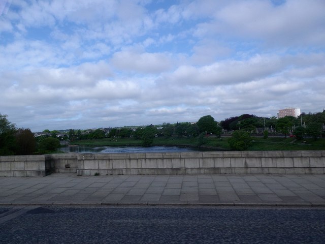
The Bridge of Dee is a historic bridge located in Aberdeenshire, Scotland. It spans across the River Dee and is considered a significant heritage site in the region.

The bridge dates back to the 16th century, with the original structure being built in 1527. It was primarily constructed to provide a crossing point over the river, connecting the towns of Aberdeen and Kincardineshire.

The Bridge of Dee is an impressive architectural feat, showcasing a traditional stone construction with multiple arches. It measures approximately 145 meters in length and has a total of seven arches. The bridge is known for its sturdy design and is a testament to the engineering capabilities of the time.

Throughout its long history, the bridge has undergone several renovations and repairs to maintain its structural integrity. In the 18th century, the Bridge of Dee was widened to accommodate the increasing traffic flow.

Today, the Bridge of Dee serves as a vital transportation link between Aberdeen and the surrounding areas. It is a busy thoroughfare for vehicles, cyclists, and pedestrians. The bridge offers picturesque views of the River Dee and the surrounding countryside, attracting tourists and locals alike.

As a heritage site, the Bridge of Dee is protected and preserved by local authorities to ensure its historical significance is maintained. It stands as a testament to the rich history and architectural prowess of Aberdeenshire, providing a glimpse into the past for visitors and residents.

If you have any feedback on the listing, please let us know in the comments section below.

Bridge of Dee Images

Images are sourced within 2km of 57.122/-2.123 or Grid Reference NJ9203. Thanks to Geograph Open Source API. All images are credited.

Looking upstream River Don From a bus crossing George VI Bridge; via B9077.
Looking upstream River Don
From a bus crossing George VI Bridge; via B9077.
Junction of B9077 with A90 At the roundabout on the south bank of the River Dee; by the Bridge of Dee, Aberdeen.
Junction of B9077 with A90
At the roundabout on the south bank of the River Dee; by the Bridge of Dee, Aberdeen.
Claremont Place, Aberdeen, at night
Red Cross Hostel, Claremont Place, Aberdeen Mainly used by families from remote areas of Scotland with relatives in the Aberdeen hospitals.
Red Cross Hostel, Claremont Place, Aberdeen
Mainly used by families from remote areas of Scotland with relatives in the Aberdeen hospitals.
Junction of Broomhill Road and Balmoral Place
Shops on Holburn Street at Balmoral Road, Aberdeen
Aberdeen - Holburn Street Busy city road lined with grey granite houses and tenement buildings.
Aberdeen - Holburn Street
Busy city road lined with grey granite houses and tenement buildings.
Aberdeen - Deeside Line Walk Footpath at the former Holburn Street Station, a halt on the GNSR's Deeside Line 1894-1937.
Aberdeen - Deeside Line Walk
Footpath at the former Holburn Street Station, a halt on the GNSR's Deeside Line 1894-1937.
Aberdeen - Old Deeside Line Footpath at the former Holburn Street Station, a halt on the GNSR's Aberdeen-Ballater Deeside Line 1894-1937.
Aberdeen - Old Deeside Line
Footpath at the former Holburn Street Station, a halt on the GNSR's Aberdeen-Ballater Deeside Line 1894-1937.
Aberdeen - Ferryhill Library Fine granite building at the west end of Fonthill Road.
Aberdeen - Ferryhill Library
Fine granite building at the west end of Fonthill Road.
Aberdeen - River Dee Islets on the southern, slower flowing, side of the Dee just downstream from Brig o' Dee.
Aberdeen - River Dee
Islets on the southern, slower flowing, side of the Dee just downstream from Brig o' Dee.
Kincorth, Aberdeen, from the air Taken from a plane on approach to Aberdeen Airport.
Kincorth, Aberdeen, from the air
Taken from a plane on approach to Aberdeen Airport.
Bridge of Dee, Aberdeen, from the air
Ruthrieston, Aberdeen, from the air Taken from a plane on approach to Aberdeen Airport.
Ruthrieston, Aberdeen, from the air
Taken from a plane on approach to Aberdeen Airport.
Great Western Road, Aberdeen, from the air Taken from a plane on approach to Aberdeen Airport.
Great Western Road, Aberdeen, from the air
Taken from a plane on approach to Aberdeen Airport.
Tillyhowes from the Aberdeen ring road
Tesco, Aberdeen South On Wellington Road, A956.
Tesco, Aberdeen South
On Wellington Road, A956.
King George VI Bridge, Ruthrieston, Aberdeen Built in 1938-1941, King George VI Bridge is a reinforced concrete bridge carrying the B9077 (Great Southern Road) across the River Dee. It is a Category B listed building. <span class="nowrap"><a title="https://www.britishlistedbuildings.co.uk/200354516-aberdeen-ruthrieston-king-george-vi-bridge-aberdeen#.WW53zzGWw5s" rel="nofollow ugc noopener" href="https://www.britishlistedbuildings.co.uk/200354516-aberdeen-ruthrieston-king-george-vi-bridge-aberdeen#.WW53zzGWw5s">Link</a><img style="margin-left:2px;" alt="External link" title="External link - shift click to open in new window" src="https://s1.geograph.org.uk/img/external.png" width="10" height="10"/></span>
King George VI Bridge, Ruthrieston, Aberdeen
Built in 1938-1941, King George VI Bridge is a reinforced concrete bridge carrying the B9077 (Great Southern Road) across the River Dee. It is a Category B listed building. LinkExternal link
Show me another place!

Bridge of Dee is located at Grid Ref: NJ9203 (Lat: 57.122, Lng: -2.123)

Unitary Authority: City of Aberdeen

Police Authority: North East

What 3 Words

///oven.jumps.butter. Near Cults, Aberdeen

Related Wikis

Battle of the Brig of Dee

The Battle of the Brig of Dee took place on 18–19 June 1639 at the Bridge of Dee in Scotland, and was the only serious military action of the First Bishops...

Bridge of Dee

The Bridge of Dee or Brig o Dee (Scottish Gaelic: Drochaid Dhè) is a road bridge over the River Dee in Aberdeen, Scotland. The term is also used for the...

Kaimhill

Kaimhill is a district in Aberdeen, Scotland. Its post code is AB10. Children attend Kaimhill Primary School and Harlaw Academy. == References ==

Ruthrieston railway station

Ruthrieston railway station or Ruthrieston Halt was opened in January 1856 by the GNSR and served Ruthrieston, now a suburb of Aberdeen. The halt was one...

Garthdee

Garthdee (Scottish Gaelic: Gart Dè) is an area of Aberdeen, Scotland. == Location == Garthdee is south west of the city centre, 3 km from Holburn Junction...

Kincorth

Kincorth is a suburb located to the south of Aberdeen, Scotland. The name is a corruption of the Scottish Gaelic "Ceann Coirthe", which probably refers...

Broomhill, Aberdeen

Broomhill is an affluent, middle class area of Aberdeen, Scotland. It is situated in the west end and is accessible by the A92 road (South Anderson Drive...

Holburn Street railway station

Holburn Street railway station was a railway station in Aberdeen, Scotland. It was opened in July 1894 by the GNSR and served a suburb of Aberdeen near...

Nearby Amenities

Located within 500m of 57.122,-2.123
Cycleway: asl
Direction: forward
Lat/Long: 57.1203763/-2.1280773
Traffic Calming: cushion
Lat/Long: 57.1212529/-2.1278848
Traffic Calming: cushion
Lat/Long: 57.1217972/-2.1274134
Traffic Calming: cushion
Lat/Long: 57.1222555/-2.1275137
Traffic Calming: cushion
Lat/Long: 57.1209132/-2.1300359
Traffic Calming: cushion
Lat/Long: 57.1227136/-2.1271234
Traffic Calming: cushion
Lat/Long: 57.1240839/-2.1262446
Traffic Calming: cushion
Lat/Long: 57.1244371/-2.1274941
Traffic Calming: cushion
Lat/Long: 57.1255114/-2.1270757
Crossing
Button Operated: yes
Crossing: traffic_signals
Crossing Ref: pelican
Tactile Paving: yes
Traffic Signals Vibration: yes
Lat/Long: 57.1217055/-2.1165934
Noexit: yes
Lat/Long: 57.1214881/-2.1172469
Crossing
Button Operated: yes
Crossing: traffic_signals
Crossing Ref: pelican
Tactile Paving: yes
Traffic Signals Vibration: yes
Lat/Long: 57.1228527/-2.1158904
Direction: both
Surface: asphalt
Traffic Calming: cushion
Lat/Long: 57.1203573/-2.1163389
Crossing
Button Operated: yes
Crossing: traffic_signals
Crossing Ref: pelican
Tactile Paving: yes
Traffic Signals Vibration: yes
Lat/Long: 57.1242361/-2.1221938
Barrier: bollard
Bollard: fixed
Source: survey
Lat/Long: 57.1248257/-2.1221713
Barrier: bollard
Bollard: fixed
Number: 1
Source: survey
Lat/Long: 57.1243597/-2.1221276
Bench
Backrest: yes
Colour: brown
Material: wood
Seats: 4
Lat/Long: 57.1250941/-2.1215878
Bench
Backrest: yes
Colour: brown
Material: wood
Seats: 4
Lat/Long: 57.1249388/-2.1217059
Crossing
Button Operated: yes
Crossing: traffic_signals
Crossing Ref: pelican
Tactile Paving: yes
Traffic Signals Sound: no
Traffic Signals Vibration: yes
Lat/Long: 57.1241645/-2.1223351
Kaimhill
Is In: Aberdeen, Aberdeen City, Scotland, United Kingdom
Place: suburb
Source: OS_OpenData_StreetView
Wikidata: Q6348022
Wikipedia: en:Kaimhill
Lat/Long: 57.1255371/-2.1254911
Cycleway: asl
Direction: backward
Lat/Long: 57.1205975/-2.1275569
Traffic Calming: cushion
Lat/Long: 57.1203486/-2.1296226
Traffic Calming: cushion
Lat/Long: 57.1219725/-2.1286925
Crossing
Button Operated: yes
Crossing: traffic_signals
Crossing Ref: pelican
Kerb: lowered
Tactile Paving: yes
Traffic Signals Vibration: yes
Lat/Long: 57.1235978/-2.1211401
Crossing
Button Operated: yes
Crossing: traffic_signals
Crossing Ref: pelican
Kerb: lowered
Tactile Paving: yes
Traffic Signals Vibration: yes
Lat/Long: 57.1234961/-2.1211506
Crossing
Button Operated: yes
Crossing: traffic_signals
Crossing Ref: pelican
Tactile Paving: yes
Traffic Signals Vibration: yes
Lat/Long: 57.1228492/-2.1160953
Crossing
Button Operated: yes
Crossing: traffic_signals
Crossing Ref: pelican
Tactile Paving: yes
Traffic Signals Vibration: yes
Lat/Long: 57.1216568/-2.116753
Crossing
Button Operated: yes
Crossing: traffic_signals
Crossing Island: no
Crossing Markings: dots
Crossing Ref: puffin
Kerb: flush
Tactile Paving: yes
Traffic Signals Vibration: yes
Lat/Long: 57.1213289/-2.1261636
Crossing
Button Operated: yes
Crossing: traffic_signals
Crossing Ref: pelican
Tactile Paving: yes
Traffic Signals Vibration: yes
Lat/Long: 57.1234313/-2.1223225
Crossing
Button Operated: yes
Crossing: traffic_signals
Crossing Ref: pelican
Tactile Paving: yes
Traffic Signals Vibration: yes
Lat/Long: 57.1234335/-2.1221166
Traffic Signals
Traffic Signals: signal
Traffic Signals Direction: both
Lat/Long: 57.1204875/-2.1277978
Post Box
Collection Times: Mo-Fr 18:45; Sa 12:00
Indoor: yes
Operator: Royal Mail
Operator Wikidata: Q638098
Post Box Type: pillar
Ref: AB10 14
Royal Cypher: no
Source: survey
Lat/Long: 57.1240701/-2.1237322
NESCAM route 2
Website: http://www.nescamp.co.uk/details?cid=92
Lat/Long: 57.1226715/-2.1170969
Speed Camera
Mobile Speed Camera Location
Ref: 2012
Website: http://www.nescamp.co.uk/details?cid=128
Lat/Long: 57.1192922/-2.1181068
Crossing
Lat/Long: 57.1235698/-2.1291046
Street Lamp
Lat/Long: 57.1222708/-2.1169423
Give Way
Lat/Long: 57.1229868/-2.122677
Fast Food
McDonald's
Addr City: Aberdeen
Addr Postcode: AB10 7QA
Addr Street: Garthdee Road
Brand: McDonald's
Brand Wikidata: Q38076
Brand Wikipedia: en:McDonald's
Contact Website: https://www.mcdonalds.com/gb/en-gb/location/aberdeen/asda-aberdeen/garthdee-road/8261341.html
Cuisine: burger
Drive Through: no
Fhrs Authority: Aberdeen City
Fhrs Id: 906418
Fhrs Local Authority Id: EHDC12015
Opening Hours: Mo-Su 12:00+
Takeaway: yes
Wheelchair: yes
Lat/Long: 57.1243243/-2.1239234
Post Box
Addr City: Aberdeen
Addr Country: GB
Addr Postcode: AB12 5UN
Addr Street: Leggart Place
Collection Times: Mo-Fr 09:00; Sa 07:00
Operator: Royal Mail
Operator Wikidata: Q638098
Post Box Type: lamp
Ref: AB12 146D
Royal Cypher: scottish_crown
Lat/Long: 57.1205753/-2.1192902
Bench
Lat/Long: 57.118926/-2.1254987
Bus Stop
Snowsports Centre
Bench: no
Bin: no
Bus: yes
Lit: yes
Naptan AtcoCode: 639001781
Naptan CommonName: Snowsports Centre
Naptan Indicator: opp
Naptan NaptanCode: 23232642
Naptan Verified: no
Public Transport: platform
Shelter: yes
Tactile Paving: no
Lat/Long: 57.1208256/-2.1270457
Bus Stop
Bridge Of Dee
Bench: yes
Bin: yes
Bus: yes
Lit: yes
Naptan AtcoCode: 639001772
Naptan CommonName: Bridge Of Dee
Naptan Indicator: before
Naptan NaptanCode: 23232695
Naptan Verified: no
Public Transport: platform
Shelter: yes
Tactile Paving: yes
Lat/Long: 57.1230124/-2.1231555
Bus Stop
Bridge Of Dee
Bench: yes
Bin: no
Bus: yes
Lit: yes
Naptan AtcoCode: 639001771
Naptan CommonName: Bridge Of Dee
Naptan Indicator: at
Naptan NaptanCode: 23232674
Naptan Verified: no
Public Transport: platform
Shelter: yes
Tactile Paving: no
Lat/Long: 57.122277/-2.1241605
Bus Stop
Snowsports Centre
Bench: yes
Bin: yes
Bus: yes
Lit: yes
Naptan AtcoCode: 639001782
Naptan CommonName: Snowsports Centre
Naptan Indicator: at
Naptan NaptanCode: 23232675
Naptan Verified: no
Public Transport: platform
Shelter: yes
Tactile Paving: no
Lat/Long: 57.1212477/-2.1264549
Bus Stop
Bridge Of Dee Court
Bench: yes
Bin: yes
Bus: yes
Lit: yes
Naptan AtcoCode: 639001762
Naptan CommonName: Bridge Of Dee Court
Naptan Indicator: opp
Naptan NaptanCode: 23232743
Public Transport: platform
Shelter: yes
Tactile Paving: no
Lat/Long: 57.1245181/-2.1211459
Bus Stop
Bridge of Dee Court
Bench: no
Bin: yes
Bus: yes
Lit: yes
Naptan AtcoCode: 639001761
Naptan CommonName: Bridge of Dee Court
Naptan Indicator: adj
Naptan NaptanCode: 23232735
Public Transport: platform
Shelter: yes
Tactile Paving: no
Lat/Long: 57.1243259/-2.1210788
Bus Stop
Ruthrieston Road
Bench: no
Bin: yes
Bus: yes
Lit: yes
Naptan AtcoCode: 639001743
Naptan CommonName: Ruthrieston Road
Naptan Indicator: opp
Naptan NaptanCode: 23236597
Naptan Verified: no
Public Transport: platform
Shelter: no
Tactile Paving: no
Lat/Long: 57.1257844/-2.1199507
Bus Stop
Great Southern Road
Bench: yes
Bin: no
Bus: yes
Lit: yes
Naptan AtcoCode: 639007121
Naptan CommonName: Great Southern Road
Naptan Indicator: at
Naptan NaptanCode: 23236769
Naptan Verified: no
Public Transport: platform
Shelter: yes
Tactile Paving: no
Lat/Long: 57.1213749/-2.1164946
Bus Stop
Leggart Road
Bus: yes
Naptan AtcoCode: 639002611
Naptan CommonName: Leggart Road
Naptan Indicator: opp
Naptan NaptanCode: 23232587
Naptan Verified: no
Public Transport: platform
Lat/Long: 57.1194568/-2.1213602
Bus Stop
Leggart Road
Bus: yes
Naptan AtcoCode: 639002421
Naptan CommonName: Leggart Road
Naptan Indicator: at
Naptan NaptanCode: 23232623
Naptan Verified: no
Public Transport: platform
Lat/Long: 57.120062/-2.1187478
Bus Stop
Leggart Place
Bus: yes
Naptan AtcoCode: 639002412
Naptan CommonName: Leggart Place
Naptan Indicator: adj
Naptan NaptanCode: 23232647
Naptan Verified: no
Public Transport: platform
Lat/Long: 57.1210431/-2.1187943
Bus Stop
Leggart Place
Bus: yes
Naptan AtcoCode: 639002411
Naptan CommonName: Leggart Place
Naptan Indicator: opp
Naptan NaptanCode: 23232646
Naptan Verified: no
Public Transport: platform
Lat/Long: 57.1208422/-2.1193499
Bus Stop
Abbotswell Drive
Bench: no
Bin: no
Bus: yes
Lit: yes
Naptan AtcoCode: 639002402
Naptan CommonName: Abbotswell Drive
Naptan Indicator: at
Naptan NaptanCode: 23232687
Naptan Verified: no
Public Transport: platform
Shelter: no
Tactile Paving: no
Lat/Long: 57.1231725/-2.1154102
Bus Stop
Abbotswell Drive
Bench: no
Bin: no
Bus: yes
Lit: yes
Naptan AtcoCode: 639002401
Naptan CommonName: Abbotswell Drive
Naptan Indicator: opp
Naptan NaptanCode: 23232728
Naptan Verified: no
Public Transport: platform
Shelter: no
Tactile Paving: no
Lat/Long: 57.1235204/-2.1152479
Post Box
Check Date Collection Times: 2022-09-02
Collection Times: Mo-Fr 09:00; Sa 07:00
Operator: Royal Mail
Operator Wikidata: Q638098
Post Box Type: pillar
Ref: AB10 174D
Royal Cypher: GR
Royal Cypher Wikidata: Q33102273
Lat/Long: 57.125275/-2.1203523
Battle of the Brig of Dee
End Date: 19/06/1639
Historic: battlefield
Start Date: 18/06/1639
Website: https://en.wikipedia.org/wiki/Battle_of_the_Brig_of_Dee
Lat/Long: 57.1225515/-2.1176668
Cafe
Asda Café
Addr City: Aberdeen
Addr Postcode: AB10 7QA
Addr Street: Garthdee Road
Brand: Asda
Brand Wikidata: Q297410
Brand Wikipedia: en:Asda
Contact Phone: +44 1224 319919
Contact Website: https://storelocator.asda.com/scotland/aberdeen/garth-dee-road-bridge-of-dee-aberdeen/cafe
Cuisine: coffee_shop
Drinking Water Refill: yes
Drinking Water Refill Network: Refill
Fhrs Authority: Aberdeen City
Fhrs Id: 592472
Fhrs Local Authority Id: EHDC10922
Fixme: Location not accurate
Internet Access: wlan
Internet Access Fee: no
Opening Hours Covid19: Mo-Su off
Operator: Asda Stores Ltd
Takeaway: yes
Lat/Long: 57.124745/-2.1232528
Asda Opticians
Brand: Asda
Brand Wikidata: Q297410
Brand Wikipedia: en:Asda
Contact Phone: +44 1224 498700
Contact Website: https://storelocator.asda.com/scotland/aberdeen/garth-dee-road-bridge-of-dee-aberdeen/opticians
Fixme: Location not accurate
Operator: Asda Stores Ltd
Shop: optician
Lat/Long: 57.1249941/-2.1233708
Leggart
Place: suburb
Lat/Long: 57.1185977/-2.1210489
Recycling
Recycling Cardboard: yes
Recycling Glass: yes
Recycling Paper: yes
Recycling Plastic: yes
Recycling Type: container
Lat/Long: 57.1209608/-2.1265373
Crossing
Button Operated: yes
Crossing: traffic_signals
Crossing Island: no
Crossing Markings: dots
Crossing Ref: puffin
Kerb: lowered
Tactile Paving: yes
Traffic Signals Sound: yes
Traffic Signals Vibration: yes
Lat/Long: 57.1247059/-2.1209003
Car Wash
Automated: no
Self Service: yes
Lat/Long: 57.122011/-2.1253369
Car Wash
Automated: no
Self Service: yes
Lat/Long: 57.1219695/-2.125265
Compressed Air
Lat/Long: 57.1220999/-2.1252421
Man Made: water_tap
Lat/Long: 57.1221283/-2.1251984
Compressed Air
Lat/Long: 57.122108/-2.1250679
Man Made: water_tap
Lat/Long: 57.1221322/-2.1250591
Compressed Air
Fee: yes
Lat/Long: 57.1212081/-2.1262563
Vacuum Cleaner
Lat/Long: 57.1211324/-2.1263248
Car Wash
Automated: yes
Self Service: yes
Lat/Long: 57.1213095/-2.1256523
Entrance: yes
Level: 0;1
Lat/Long: 57.1240537/-2.1239435
Argos
Addr City: Aberdeen
Addr Housenumber: 45-47
Addr Postcode: AB10 7AY
Addr Street: Garthdee Road
Brand: Argos
Brand Wikidata: Q4789707
Brand Wikipedia: en:Argos (retailer)
Contact Website: https://www.argos.co.uk/stores/4402-aberdeen-garthdee-argos-in-sainsburys
Fhrs Authority: Aberdeen City
Fhrs Id: 1178268
Fhrs Local Authority Id: EHDC12362
Shop: catalogue
Lat/Long: 57.1205231/-2.1247931
Timpson
Brand Wikidata: Q7807658
Brand Wikipedia: en:Timpson (retailer)
Shop: shoe_repair
Lat/Long: 57.1202797/-2.1252977
Entrance: yes
Lat/Long: 57.1205031/-2.125013
Entrance: yes
Lat/Long: 57.1214599/-2.1236692
Colour: green
Man Made: street_cabinet
Operator: Cityfibre
Ref: AB2.PN34.SN2
Telecom Medium: fibre
Utility: telecom
Lat/Long: 57.1204306/-2.1182086
Barrier: bollard
Bollard: fixed
Lat/Long: 57.1217016/-2.1311719
Max Spielmann
Addr City: Aberdeen
Addr Postcode: AB10 7QA
Branch: Photo Centre
Brand: Max Spielmann
Brand Wikidata: Q76221051
Opening Hours: Mo-Sa 09:00-18:00; Su 10:00-16:00
Phone: +44 1224 324 070
Shop: photo
Website: https://www.maxphoto.co.uk
Wheelchair: yes
Lat/Long: 57.1245201/-2.1240172
Access: private
Addr City: Aberdeen
Addr Country: GB
Addr Housenumber: 649
Addr Postcode: AB10 7JN
Addr Street: Holburn Street
Entrance: yes
Lat/Long: 57.1244962/-2.1208428
Colour: white
Man Made: street_cabinet
Operator: Cityfibre
Utility: telecom
Lat/Long: 57.1247267/-2.1207264
Access: private
Addr City: Aberdeen
Addr Country: GB
Addr Housenumber: 637
Addr Postcode: AB10 7JN
Addr Street: Holburn Street
Entrance: yes
Lat/Long: 57.1249093/-2.1205528
Access: private
Addr City: Aberdeen
Addr Country: GB
Addr Housenumber: 635
Addr Postcode: AB10 7JN
Addr Street: Holburn Street
Entrance: yes
Lat/Long: 57.1249658/-2.1205076
Access: private
Addr City: Aberdeen
Addr Country: GB
Addr Housenumber: 629
Addr Postcode: AB10 7JN
Addr Street: Holburn Street
Entrance: yes
Lat/Long: 57.1251347/-2.1203677
Access: private
Addr City: Aberdeen
Addr Country: GB
Addr Housenumber: 627
Addr Postcode: AB10 7JN
Addr Street: Holburn Street
Entrance: yes
Lat/Long: 57.1251681/-2.1202425
Access: private
Addr City: Aberdeen
Addr Country: GB
Addr Housenumber: 611A
Addr Postcode: AB10 7JN
Addr Street: Holburn Street
Entrance: yes
Lat/Long: 57.1255582/-2.1199587
Access: private
Addr City: Aberdeen
Addr Country: GB
Addr Housenumber: 611
Addr Postcode: AB10 7JN
Addr Street: Holburn Street
Entrance: yes
Lat/Long: 57.1255311/-2.1200682
Clinic
Chinese Acupuncture Clinic
Addr City: Aberdeen
Addr Country: GB
Addr Housenumber: 605
Addr Postcode: AB10 7JN
Addr Street: Holburn Street
Healthcare: alternative
Healthcare Speciality: acupuncture
Lat/Long: 57.1256703/-2.1199516
Access: private
Addr City: Aberdeen
Addr Country: GB
Addr Housenumber: 609
Addr Postcode: AB10 7JN
Addr Street: Holburn Street
Entrance: yes
Lat/Long: 57.1255979/-2.1200079
Addr City: Aberdeen
Addr Country: GB
Addr Housenumber: 607
Addr Postcode: AB10 7JN
Addr Street: Holburn Street
Entrance: yes
Lat/Long: 57.1256549/-2.119988
Grit Bin
Lat/Long: 57.1250315/-2.1221333
Generator Method: photovoltaic
Generator Output Electricity: yes
Generator Source: solar
Generator Type: solar_photovoltaic_panel
Location: roof
Power: generator
Lat/Long: 57.118693/-2.1217574
Crossing
Crossing: traffic_signals
Crossing Island: no
Crossing Ref: tiger
Tactile Paving: yes
Lat/Long: 57.1218734/-2.1176959
Crossing
Crossing: unmarked
Crossing Island: no
Crossing Markings: no
Tactile Paving: yes
Lat/Long: 57.11815/-2.1229808
Grit Bin
Lat/Long: 57.1189114/-2.1170897
Direction: both
Surface: asphalt
Traffic Calming: cushion
Lat/Long: 57.1197144/-2.1164637
Direction: both
Surface: asphalt
Traffic Calming: cushion
Lat/Long: 57.1207452/-2.1152085
Direction: both
Surface: asphalt
Traffic Calming: cushion
Lat/Long: 57.1201529/-2.1156938
Direction: both
Surface: asphalt
Traffic Calming: cushion
Lat/Long: 57.1216308/-2.1152528
Direction: both
Surface: asphalt
Traffic Calming: cushion
Lat/Long: 57.1209905/-2.115799
Crossing
Crossing: unmarked
Crossing Island: no
Crossing Markings: no
Kerb: flush
Tactile Paving: no
Lat/Long: 57.1240409/-2.1213404
Crossing
Crossing: unmarked
Crossing Island: no
Crossing Markings: no
Kerb: flush
Tactile Paving: no
Lat/Long: 57.1241073/-2.1214825
Noexit: yes
Lat/Long: 57.1227951/-2.1280157
Traffic Calming: table
Lat/Long: 57.1225425/-2.1287318
Crossing
Lat/Long: 57.1228781/-2.1282564
Bicycle Repair Station
Lat/Long: 57.1239916/-2.1201414
Barrier: cycle_barrier
Bicycle: yes
Foot: yes
Lat/Long: 57.1239756/-2.1201224
Generator Method: photovoltaic
Generator Output Electricity: yes
Generator Source: solar
Generator Type: solar_photovoltaic_panel
Location: roof
Power: generator
Lat/Long: 57.1213009/-2.1280244
Generator Method: photovoltaic
Generator Output Electricity: yes
Generator Source: solar
Generator Type: solar_photovoltaic_panel
Location: roof
Power: generator
Lat/Long: 57.1205969/-2.1292421
Grit Bin
Lat/Long: 57.1221501/-2.1305242
Traffic Calming: cushion
Lat/Long: 57.1213223/-2.1291878
Traffic Calming: cushion
Lat/Long: 57.120966/-2.1307006
Traffic Calming: cushion
Lat/Long: 57.1214334/-2.1309547
Traffic Calming: cushion
Lat/Long: 57.1218342/-2.131172
Traffic Calming: cushion
Lat/Long: 57.1207679/-2.1286252
Crossing
Crossing: unmarked
Crossing Island: no
Crossing Markings: no
Kerb: lowered
Tactile Paving: yes
Lat/Long: 57.1245241/-2.1262521
Traffic Calming: cushion
Lat/Long: 57.12425/-2.1286668
Grit Bin
Lat/Long: 57.1248917/-2.1281498
Post Box
Collection Times: Mo-Fr 17:00; Sa 11:45
Operator: Royal Mail
Ref: AB10 150
Royal Cypher: GVIR
Lat/Long: 57.1241652/-2.1297035
Grit Bin
Lat/Long: 57.124459/-2.1261301
Traffic Calming: cushion
Lat/Long: 57.122315/-2.1282001
Traffic Calming: cushion
Lat/Long: 57.1220602/-2.1294393
Crossing
Crossing: unmarked
Crossing Island: no
Tactile Paving: yes
Lat/Long: 57.1198491/-2.1269126
Generator Method: photovoltaic
Generator Output Electricity: yes
Generator Source: solar
Generator Type: solar_photovoltaic_panel
Location: roof
Power: generator
Lat/Long: 57.1213627/-2.1311957
Grit Bin
Lat/Long: 57.1224098/-2.1287313
Crossing
Button Operated: yes
Crossing: traffic_signals
Crossing Island: no
Kerb: lowered
Tactile Paving: yes
Traffic Signals Vibration: yes
Lat/Long: 57.1204043/-2.1276876
Crossing
Button Operated: yes
Crossing: traffic_signals
Crossing Island: no
Kerb: lowered
Tactile Paving: yes
Traffic Signals Vibration: yes
Lat/Long: 57.120573/-2.1276105
Crossing
Button Operated: yes
Crossing: traffic_signals
Crossing Island: no
Kerb: lowered
Tactile Paving: yes
Traffic Signals Vibration: yes
Lat/Long: 57.1204057/-2.1280034
Grit Bin
Survey Date: 2022-07-23
Lat/Long: 57.1196321/-2.1171076
Crossing
Crossing: uncontrolled
Crossing Markings: yes
Lat/Long: 57.1209834/-2.1240601
Addr Housenumber: 68
Addr Street: Garthdee Drive
Entrance: yes
Lat/Long: 57.1240229/-2.1299382
Give Way
Direction: forward
Lat/Long: 57.1181645/-2.1230146
Give Way
Direction: forward
Lat/Long: 57.1226679/-2.1160659
Give Way
Direction: backward
Lat/Long: 57.1198725/-2.1175184
Give Way
Direction: forward
Lat/Long: 57.1227743/-2.122094
Crossing
Crossing: uncontrolled
Crossing Island: no
Crossing Markings: zebra
Crossing Ref: zebra
Direction: both
Flashing Lights: no
Traffic Calming: table
Lat/Long: 57.1228342/-2.1222172
Addr Housenumber: 41-48
Addr Street: Headland Court
Entrance: yes
Lat/Long: 57.1262515/-2.1234538
Addr Housenumber: 49-56
Addr Street: Headland Court
Entrance: yes
Lat/Long: 57.1260995/-2.1234408
Addr Housenumber: 1-7
Addr Street: Headland Court
Entrance: yes
Lat/Long: 57.1264003/-2.1235146
Waste Basket
Lat/Long: 57.1245274/-2.1261192
Waste Basket
Waste: dog_excrement
Lat/Long: 57.1251472/-2.1277717
Bench
Backrest: yes
Lat/Long: 57.1241247/-2.1225903
Bench
Backrest: yes
Lat/Long: 57.1241407/-2.1226466
Bench
Backrest: yes
Lat/Long: 57.1241024/-2.1228412
Grit Bin
Lat/Long: 57.1240984/-2.1225424
Bench
Backrest: yes
Lat/Long: 57.1241287/-2.122784
Waste Basket
Lat/Long: 57.124136/-2.1227133
Street Lamp
Lat/Long: 57.1238309/-2.1217961
Addr Housenumber: 626
Addr Street: Holburn Street
Entrance: yes
Lat/Long: 57.1254372/-2.1206121
The data included in this document is from www.openstreetmap.org. The data is made available under ODbL.

Have you been to Bridge of Dee?

Leave your review of Bridge of Dee below (or comments, questions and feedback).